It only takes one right? Winter 2021-2022 has been relatively quiet across much of New England with most locations below normal on the year for snowfall. That may be about to change this weekend.
Many of the weather computer guidance models are indicating the potential for a rather significant storm system for the Friday night and Saturday period.
What do we know right now?
- A significant storm system will be somewhere off the east coast.
- Temperatures are sufficiently cold for snow (storm track dependent).
- The tide cycle is astronomically high.
The Set-up
Friday afternoon an area of low pressure will begin organizing off the southeast coastline.

From here the storm system will progress north-northeast up the coast.
As you can see from the model simulation above the storm system is currently forecasted to pass close enough to New England to overspread the region with snowfall. We are still ~4 days away from first snowflakes so the track is far from set in stone. So will hold off on snowfall amounts for now.
Key Takeaways
- A significant storm system is likely to form off the east coast Friday into Saturday.
- The airmass is sufficiently cold for snowfall depending on track. A closer track could introduce the idea of a mix or changeover to rain.
- In addition to snow, strong winds and coastal flooding are a concern due to both the strength of the storm itself and astronomically high tides.
- Specific details such as snow amounts and exact timing are to be refined in the coming days.
In summary, the potential is there for a storm system where one measures snowfall with a yard stick rather than a ruler. However, a lot can change over the next few days. Stay tuned.
-Chris
After an impressively warm first three weeks of October, Mother Nature has decided that it is time for fall. This past weekend featured cool, crisp air and primarily sunny blue skies. However, this work week is one of clouds and rain with cold damp temperatures.
October Temperature Departures
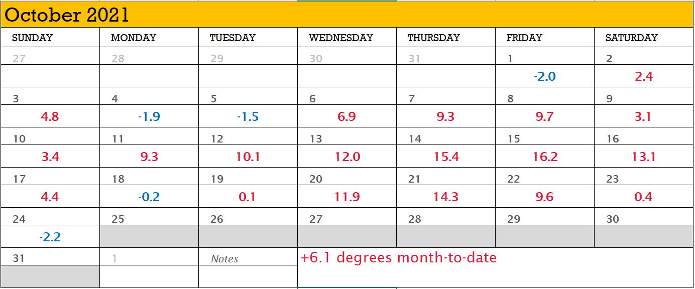
The weather station at Worcester, MA is running 6.1 degrees Fahrenheit above normal month-to-date with 19 of 24 days above normal! But that’s changing.
Nor’easter #1
The warmth that we’ve been experiencing has come to an end as the first nor’easter of the season is on our doorstep. Today’s cool and damp conditions will be followed by even more as a nor’easter moves in for Tuesday and Wednesday.
Above I’ve presented one computer guidance model’s interpretation of the storm systems progression over the next couple days. An area of low pressure will strengthen as it moves north along the east coast and will loop or stall briefly south of Long Island. The storm center itself will be quite strong with its atmospheric pressure bottoming out around 970 mb; potentially equivalent to a minimal hurricane in intensity.
With it, the storm will bring a prolonged period of rain and wind, coastal erosion and flooding, and cool-to-cold temperatures (relative to what we’ve experienced month-to-date).
Rainfall Potential
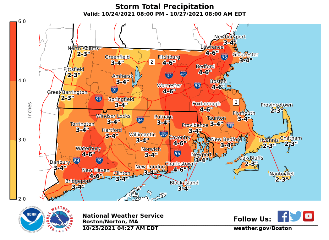
Storm total rainfall amounts on the order of 2-5″ are possible from the storm system. In terms of confidence in the forecasted amounts; greater confidence in the forecast the further south and east one resides. If you live further north and west, lower confidence in the amounts if the storm does not progress as far north as expected.
As a result of these forecast amounts, flood watches have been raised for the area.
Strong Winds
In response to the storms central pressure dropping into the low 970s, strong north and northeast winds will develop and overtake the region. Consistent with previous storms, the further one lives from the ocean, the lower the wind speeds and gusts will be. Those along the coast or inside of route 128 may experience winds greater than 50 mph. With trees primarily full of leaves and a soggy ground, power outages are possible. So best to be prepared.
Coastal Concerns
For those of you who live on the immediate coast and those flood prone areas (you know who you are), with a strong north, northeast fetch, coastal erosion and flooding concerns are moderate-to-high. Those areas that are prone to coastal flooding should expect issues.
Peek into the Future
The pattern across the eastern US is turning active. Tomorrow’s nor’easter appears to be the first in a series of storm systems to impact the east coast with additional storms possible both Halloween weekend and towards the end of next week.
-Chris
Hello all! Long time no blog. But then again the weather has been pretty boring across New England the last couple months. The area is actually just pulling out of the pretty significant drought. Most locations were classified as experiencing severe or extreme drought conditions earlier this fall.
That will change going forward as we continue to transition from summer to winter. Temperatures are certainly getting colder and more instances of cool/damp weather are moving in.
Aside from an occasional sprinkle, all eyes this week are on Thursday/Friday. Hurricane Zeta is currently down in the Caribbean on its way to landfalling in the Yucatan Peninsula tonight followed by the Gulf Coast later this week.
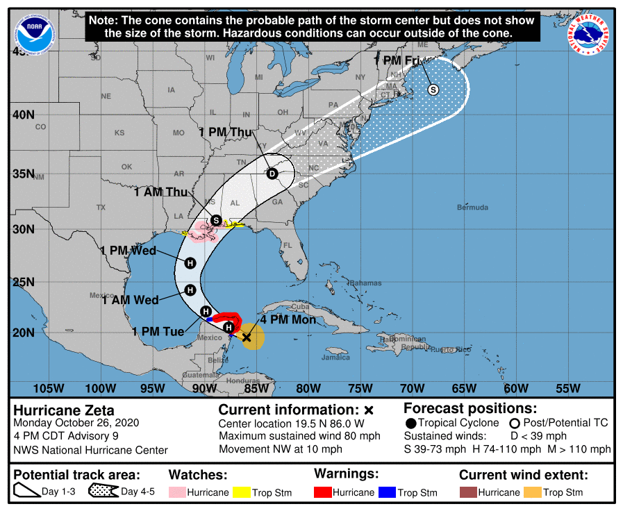
After landfalling along the Gulf Coast, Zeta will be picked up by the jet stream and bee-line for the southern New England coast. A period of heavy rain moves in from the southwest Thursday afternoon.
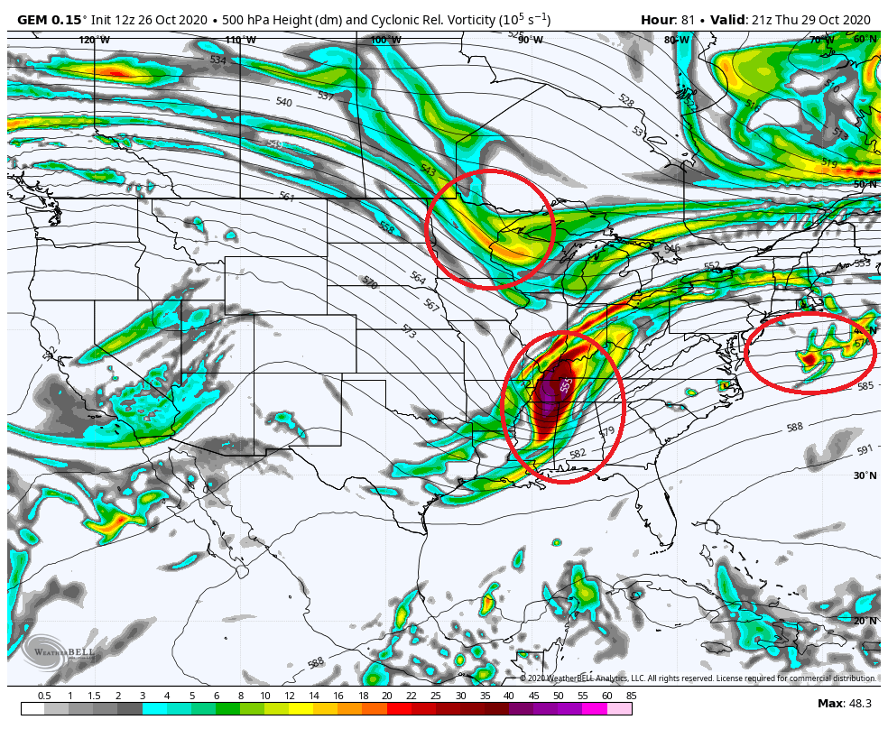
At the same time, two energetic systems follow immediately behind Zeta’s remnants and generate a second heavier period of precipitation overnight Thursday into Friday morning. Shown below for reference is a plot of the upper atmospheric energy late Thursday afternoon. I have circled the three players in the system.
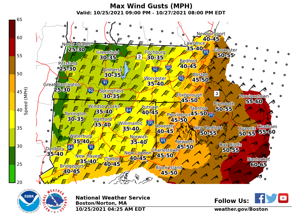
Overnight Thursday into Friday as the next period of heavier precipitation reorganizes cold air will filter southward out of Canada and may flip the rain over to snow from north to south.
The atmospheric column may cool enough that most locations may end as snowflakes on Friday. Accumulations may be possible outside of 495 and particularly north of route 2.
Definitely the first interesting storm system of the late fall and worth keeping an eye on.
-Chris

Tropical Storm Isaias Water Vapor – Tropical Tidbits, LLC
Tropical Storm Isaias continues to march northward along the Florida/Georgia coastline this morning. A turn more towards the northeast is expected to commence shortly. Headed for landfall near the South Carolina/North Carolina border, Isaias may flirt with hurricane strength just prior to landfall.

Five Day Forecast Cone – National Hurricane Center
Following landfall Isaias will accelerate north along the I-95 corridor and into Canada. During the storms journey north periods of heavy rain and gusty winds can be expected. Due to the Isaias’s speed, the flash flooding threat is low, but not nonexistent. The flash flood risk potential is outlined below.

Flash Flood Risk – Weather Prediction Center
Monday is primarily quiet across New England as we watch the radars back to the southwest. Rain moves in Tuesday.
Tuesday -> Wednesday AM

Tuesday 6 am -> Wednesday 11 am Precip & MSLP – WeatherBell, LLC
As shown above the center of the system tracks through western New England and up the Connecticut River Valley. This means that heaviest axis of rain will be across western New England and New York. Potential rainfall from the system can be found below.

Potential Rainfall – WeatherBell, LLC
In terms of wind potential, opposite to rainfall, the strongest, consistent wind gusts occur on the east side of the system. Potential wind gusts on the order of 30-50 mph for most shown below.

Potential Wind Gusts – WeatherBell, LLC
Isaias is a distant thought by late Wednesday and the second half of the week looks ok. Afternoon temperatures in the mid 80s with slightly lower dew points near 60 will make for a comfortable end to the work week.
-Chris

Tropical Storm Isaias IR Satellite – Tropical Tidbits, LLC
Hello all. Tropical storm Isaias continues to spin just east of the Florida coast line as it continues its journey northward. According to the 8 AM advisory from the National Hurricane Center, Isaias is currently moving northwest at 8 mph and has winds up to 65 mph.

Forecast Cone – National Hurricane Center
Isaias is not expected to regain hurricane status for the remainder of its existence. Today & tomorrow, Isaias will drift northward very near the Florida coast, most likely scraping the beaches before turning slightly more northeastward and land falling along the South Carolina shore.

Five Day ECMWF Ensemble Members – WeatherNerds
Following landfall in the Carolinas, Isaias is not expected to move back out into the Atlantic, rather the system will commute up I-95 into the Northeast. Isaias will accelerate northward Tuesday and Wednesday as the system interacts with a piece of the jet stream diving into the eastern third of the US. Coincidentally, Isaias enters the jet stream in a favorable position to allow for a gradual weakening rather than abrupt, even though the system is over land.
Monday

Monday Forecast Radar & MSLP – Tropical Tidbits, LLC
Isaias wobbles along the Florida coast during the day Monday before making land fall near or just north of Charleston, South Carolina Monday night.
Tuesday

Tuesday Forecast Precipitation & MSLP – WeatherBell, LLC
It’s not to difficult to notice that Isaias covers a lot more ground on Tuesday when compared to Monday. As Isaias accelerates northward on I-95, rain will begin to form out ahead of the storm as Isaias interacts with the jet stream. Locally most of Tuesday may be dry, but with a tropical air mass moving in, rain is possible any time of the day.
New England

Tue 8 pm – Wed 8 pm – WeatherBell, LLC
Locally a brief heavy period of rain will move through overnight Tuesday into Wednesday. East of the storm track rain totals will be between 0.5-1″ with locally higher and lower amounts. Western areas could receive as much as 3-5″ of rain with localized flashed flooding.

Storm Total Rainfall – WeatherBell, LLC
As tropical systems progress northward up the east coast, historically, the storms take on an asymetrical shape with heavy rains to the west of center and the stronger winds to the east of center. Which is why the heavier amounts are found west of I-95 in the image above and why the stronger winds are primarily east of I-95 shown below.

Maximum Wind Gusts – WeatherBell, LLC
As a reminder, with tropical systems impacting New England, the primary threat is heavy rain with lesser threats from damaging winds or the isolated tornado. Beyond Isaias, the forecast here in New England looks quite nice with temperatures in the 80s through the weekend.
-Chris
Late yesterday the Air Force Recon plane surveying Isaias discovered a stronger than expected storm with winds of up to 80 mph; officially making Isaias a hurricane.

Hurricane Isaias – Tropical Tidbits, LLC.
Isaias still has a bit of organization to do to take on the classic hurricane appearance but don’t be fooled, this is a potent system. Hurricane warnings are in effect for all of the Bahamian Islands; while hurricane watches are posted for the east coast of Florida.

NHC Forecast Track & Warnings – National Hurricane Center
Presented above is the 8 am forecast track for Isaias from the National Hurricane Center. Consistent with my message yesterday, all coastal locals from Miami to Maine may experience impacts from the storm.
So, what does the computer guidance say about Isaias? Overall, there is pretty good agreement amongst the ensemble guidance regarding the future track of the system. (An ensemble is a forecast system where each iteration is tweaked slightly to produce a range of outcomes; hence the numerous lines of “spaghetti”) The black lines represent the mean of the assorted outcomes.
European Ensemble

European Ensemble Members – WeatherNerds
American Ensemble

GEFS Members – WeatherNerds
UK Ensemble

UKMET Ensemble Members – WeatherNerds
Overall the theme is consistent featuring a storm system tracking through the southern and western Bahamas, skirting the Florida coast (potentially making landfall), likely making landfall in the Carolinas, then paralleling the northeast coast into southern New England.
For our purposes here in southern New England, most guidance brings a storm system of tropical storm intensity very near or over southern New England late Tuesday or early Wednesday. That means a period of very heavy rain and strong winds is possible for the region. Certainly stayed tuned.
-Chris
Your first thought when seeing the title of this blog was probably “Really Chris?”. 2020 continues to throw everything it can at us. Next up on the list is a tropical system potentially impacting the east coast of the United States.

Tropical Storm Isaias Satellite – Tropical Tidbits LLC
Isaias is currently moving northwest along the northern coast of Hispaniola. Satellite loops of the system show a healthy storm system with signs of potential strengthening beginning to show. Particularly the improvement of the storms cirrus canopy. A sign that the “engine” of the system is exhausting properly.
The 5 PM update from the National Hurricane Center documents a strong Tropical Storm with winds of 60 mph moving northwest towards the Bahama Islands. Based on the 5 pm forecast, Isaias is expected to become a hurricane sometime late tomorrow. Below is the latest forecast cone from the NHC.

NHC Forecast Cone
Certainly it isn’t hard to notice that anyone from Miami, FL to Portland, ME is within the cones potential track. Certainly with southern New England in the forecast cone we will need to keep an eye on Isaias over the weekend. Stay tuned.
-Chris
Hello all! I hope you have enjoyed this pleasant stretch of weather that the region has been experiencing. With daytime high temperatures in the low to mid 70s and overnight temps as low as the 40s in spots; this combination has made for quite an enjoyable stretch to this late spring period.
That all changes over the coming days though. Above normal atmospheric temperatures have been gathering to the regions west and north and is finally set to overtake us for the next week or so.

850 mb Temperature Anomaly – Pivotal Weather, LLC
Shown above are the atmospheric temperature anomalies at roughly 5,000 ft above the surface. The atmosphere’s temperature above the surface is a good indicator of potential surface temperatures in that typically the warmer the air aloft is, then the warmer the air at the surface can become.
As I set the map in motion below, you’ll notice that anomalously warm temperatures become a fixture for the region for the next 10 days or so.

June 17 – 27 850 mb Temperature Anomaly – Pivotal Weather, LLC
Presented below are a series of meteograms which identify daily high and low temperatures for a location. All meteograms are courtesy of WeatherBell, LLC. In general, there will be a north to south gradient of temperatures with generally warmer temperatures found further north. The oceans influence can easily be seen when you compare Boston and Portland to the other locations.
Boston, MA (Logan Airport)

Worcester, MA

Providence, RI

Hartford, CT

Nashua, NH

Concord, NH

Burlington, VT

Portland, ME

Bangor, ME
 Stay cool. Stay safe. Maintain social distancing as we continue to weather the coronavirus storm.
-Chris
As New England continues to experience all that the weather spectrum has to offer this month, tomorrow’s forecast brings with it the threat of severe weather! The Storm Prediction Center in Norman, Oklahoma has issued an Enhanced Risk for severe thunderstorms tomorrow across the region.

SPC Day 2 Outlook
As shown in the legend bottom right in the graphic above, an Enhanced Risk is the 3rd of 5 outlook categories.
So, what might the day on Friday look like?
12 am -> 8 am
A few sprinkles or showers leftover from Thursday’s convection move through the region very early Friday morning.

Midnight to 8 am Simulated Radar – WeatherBell, LLC
8 am -> 2 pm
Once the leftover showers push off the coast all eyes turn to the southwest. The atmosphere over southern New England Friday morning is not conducive for thunderstorms. But during the day on Friday a warm front will progress northward through the region and warm, dew point rich air will flood the area.
Shown below are 2m dew point temperatures from 8 am to 2 pm. It’s easy to see how moisture rich air moves in from the southwest.

2m Dew Points: 8 am to 2 pm – WeatherBell, LLC
The combination of a moisture rich atmosphere and temperatures in the mid 70s primes the atmosphere for convection. Now all that is missing is a trigger.
2 pm -> 8 pm
That’s where atmospheric fronts come in. Front’s represent the boundary between two air masses with different characteristics. Shown in the loop above was a warm front lifting northward through the area pushing dry air northward and allowing moisture rich air into the region.
Friday afternoon that same warm front will still be hanging around while a cold front moves in from the west.

Friday Evening Frontal Set-up – Pivotal Weather, LLC
These front combined with a favorable upper atmospheric wind profile will trigger thunderstorms during the afternoon. There is some discrepancies in terms of storm timing among the computer guidance, but in general, the threat of thunder lasts from 3 pm to 10 pm.
The simulated radar for Friday afternoon from one of the computer guidance models looks like so:

Friday 3 pm to 10 pm Simulated Radar – WeatherBell, LLC
In general, areas outside of 495 are favored for the combination of storm timing and distance from cool ocean water. The wild card in tomorrow’s forecast is a potential backdoor cold front. A backdoor cold front is when cool marine air moves from east to west across the region. These often occur during warm spring days when ocean temperatures are cool. Right now most guidance keeps it confined to the immediate coast and inland areas of north shore, but it’s something to keep an eye on.
Assuming the forecast holds overnight, a morning blog will provide the latest.
-Chris
Hello all & happy Thursday to you. Not actually a bad day out there today. Pretty gorgeous when one considers the weather we’ve had. Temperatures are approaching 60 across much of the area with some fair weather cumulus clouds bubbling up.

Thursday Noon-time Satellite – College of DuPage
Sadly….enjoy it because the weather goes down hill tomorrow evening. See that pink blob in Canada….that’s the tropospheric polar vortex and its headed our direction.

700 mb Temperatures – WeatherBell, LLC
Friday
Overnight Thursday into pre-dawn Friday leftover showers move through the region bringing a sprinkle or two to many spots.

Thursday Overnight into Friday Morning – WeatherBell, LLC
Locally during the day on Friday, the weather is quiet with temperatures reaching into the 50s. A weak storm system moving through the Ohio River Valley approaches from the southwest late in the day. This system is riding along the leading edge of the much colder air mass to our north and west.

Friday MSLP & P-Type – WeatherBell, LLC
Friday Night
As the weak system passes over the Cape Friday night it will bring showers and periods of precipitation to the region. The airmass is so cold that snow may fall on the western edge of the precipitation shield and flakes may even make it to the coast early Saturday morning.

Friday Night Storm System – WeatherBell, LLC
Any accumulations will be confined to the highest elevations.

NWS Boston Snowfall Forecast
Saturday
While snow in May is exceedingly rare many of us won’t see it. But that doesn’t mean the weather on Saturday doesn’t have the potential to be wild with the polar vortex over our heads. In addition to a legit snow storm for northern New England (below), Saturday for the rest of us will be cool (40-45 F), windy (gusts 40-50) with occasional snow squalls.

NWS Snowfall Forecast – WeatherBell, LLC
Sunday
Things slowly return to normal on Sunday with temperatures approaching 50 and wind gusts dying down. Still going to be brisk though.
The airmass above our heads is still going to be rather chilly through mid-week next week. Any hope of real warmth isn’t until next weekend.
-Chris
