Today’s rain is brought to you buy an anomolous upper level trough that dropped south out of Canada and is now progressing through the Great Lakes.
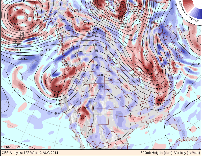
500 mb Heights
The image above is the 12 z analysis that clearly shows an extreme dip in the upper level pattern over the eastern Great Lakes. A pattern such as this is not typical for this time of year, but is more of a winter-type atmospheric evolution. (Side Note: If this pattern holds through this winter: then look out!!)
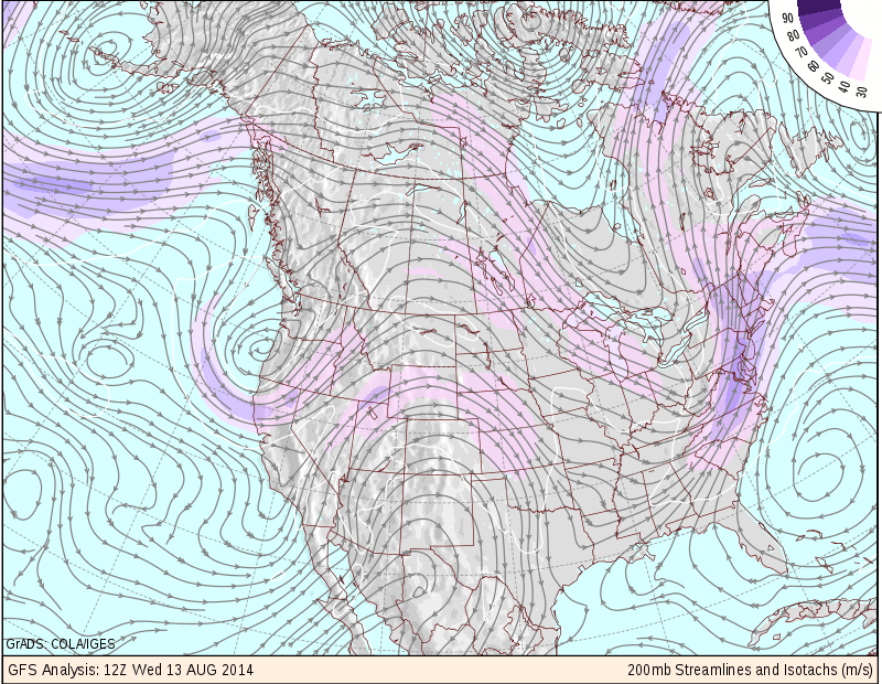
200 mb Streamlines
The image above is the 12z analysis of the upper level wind pattern. While this one is a little more difficult to read the key components are the shades of purple moving over New England; representing a region of stronger winds aloft. And the lines with arrows (known as streamlines) represent the flow of air aloft. If you look closely over Southern New England you notice that the lines appear to be getting further apart from one another. This seperation of the wind field aloft is called Divergence. To make things simple divergence aloft is associated with rising air motion. Rising air motion is what is needed to create clouds and rain.
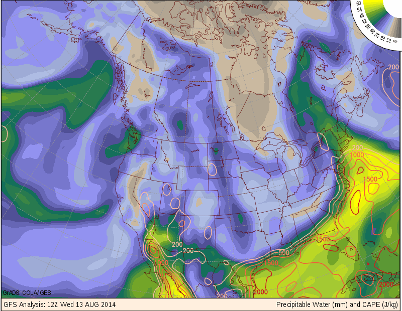
Precipitable Water
The combination of the upper level trough which is good for storm development with the divergence aloft which is also good for storm development are only two ingrediants into this rain events receipe. The third one is very moisture heavy air. The green and yellow shadings represent very high moisture laden air; meaning that when it rains, that a lot of water is going to fall from the sky. The image above combined with the 200 mb wind image seem to promote the idea that our air is coming from the Gulf of Mexico.
All 0f these factors combined to produce a record breaking event on Long Island this morning where more than a foot of rain fell in some locations. The follwing image is of doppler radar estimated rainfall amounts from the National Weather Service. Flooding this morning on Long Island was widespread.
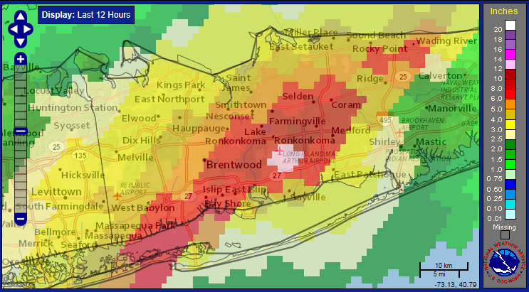
Radar Estimated Rainfall Totals
Today is just a rainy and windy day all around. Things get better for the weekend.
-Chris
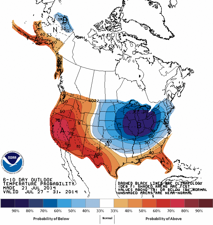
CPC 6-10 day Temp Anomaly Outlook
The image above is the 6 to 10 day temperature anomaly outlook from the Climate Prediction Center. The outlook shows that the upper Midwest, Great Lakes and Northeast are looking at a period of below normal temperatures moving in. As air from central and northern Canada invades the eastern half of the country daily temperatures should fall a few degrees below normal. Which can be seen in the 7 day where as we get into early next week afternoon highs are in the upper 70s to near 80.
But before we get to this period of comfortable temperatures we have to go through a couple of rather warm days starting today and carrying into tomorrow. Todays highs will reach for 90 and tomorrows will reach into the 90s with a few locals possibly coming in upwards of 95. All of this ahead of a cold front that is slowly sweeping its way across the upper Midwest.
As the cold front approaches New England showers and storms will enter the forecast beginning late tomorrow afternoon/evening as storms that fire way to our west attempt to make it into Southern New England during the late evening hours. Northern New England has the better chance for storms on Wednesday where a few storms may be severe as shown by the image below from the Storm Prediction Center who feel that there is a slight risk (15%) chance of a severe storm across portions of Maine, New Hampshire & Vermont.
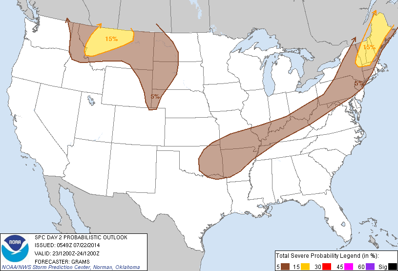
Day 2 Severe Outlook from SPC
The better chance of showers/storms comes during the overnight hours in Southern New England and likely into the morning hours of Thursday. Depeding on the eastward progression of the cold front afternoon storms are possible across far eastern portions of New England Thursday.
After the front moves through much cooler air will return and set us up for a string of rather nice days beginning likely with Thursday and lasting until Sunday. Then say from late Sunday through early next week showers and storms will be possible as an upper level disturbance from Canada moves in. This is the same disturbance bringing cooler temps with it. And with those cooler temps comes the chance for rain.
Wednesday: Chance of a late evening shower or storm. Storms possible overnight. Afternoon highs 90 to 95. Winds gusting 10-20 at times.
Thursday: Morning sprinkle possible. Afternoon showers possible along south coast/Cape & Islands. High temps in the upper 70s to near 80.
Friday: Highs near 85.
Saturday: Afternoon highs in the upper 80s.
Sunday: Showers and storms likely. Highs in the mid to upper 80s.
Monday: Isolated showers and storms. Highs in the upper 70s to near 80.
Tuesday: Showers and storms possible. Highs around 80.
-Chris
Does everyone remember the wonderful stretch of weather that we had this past weekend and Monday? Three straight days with afternoon highs in the 80s and finally the mid to high 80s on Monday.
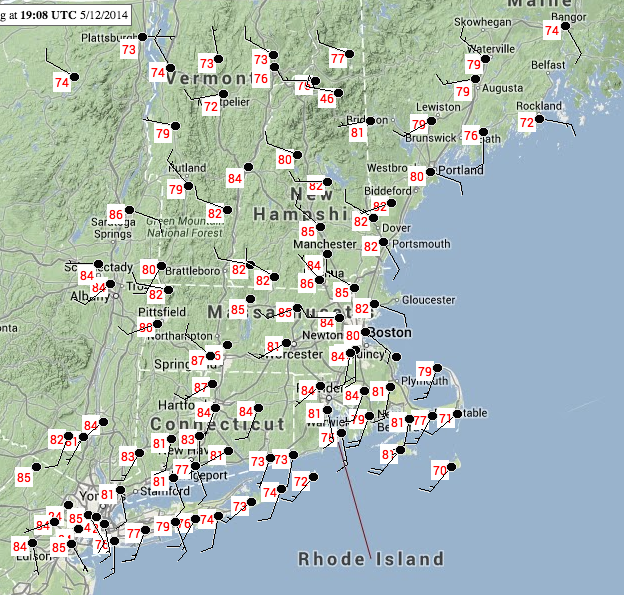
5/12/14 High Temps
Then remember waking up on Tuesday to temperatures never getting out of the low 50s on Tuesday? Waking up wondering what the heck happened to that wonderful stretch of weather and questioning how we could swing from near 90 to barely above 50 in under 24 hours.
Such a drastic change was due to a backdoor cold front that moved through Southern New England late Monday night and very early Tuesday morning.
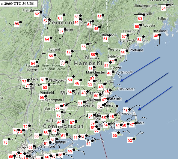
3 pm 1/13/14 Temps
Comparing the two images above there was an obvious change in wind direction. Well a wind direction change is associated with the passage of a frontal boundary. This frontal boundary was a cold front and it just so happens that this cold front came from an unusual direction. Instead of traversing New England from west to east like the majority of our weather systems due; a backdoor cold front moves from northeast to southwest across eastern portions of New England bringing cooler Gulf of Maine air with it.
Backdoor cold fronts are not that uncommon across our portion of the country. Heat waves are often ended by a backdoor cold front. And while three days in the 80s doesn’t qualify as a heat wave; Monday night’s backdoor cold front did end a three day stretch of temperautres that could be considered warm for May.
To show you how this version of a backdoor cold front formed let me present to you the Daily Weather Map graphics from the Hydrometeorological Prediction Center. The first one will be from Monday where highs were in the upper 80s. The second one will be from Tuesday where our temperatures struggle to remain in the low 50s.
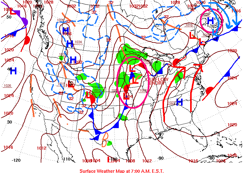
5/12/14 Daily Weather Map
In the image for Monday I have circled the two main synoptic weather systems that were in control of the weather across New England. Circled are a developing area of low pressure across the Northern Plains and a high pressure center located across southeastern Canada. Ahead of the developing low pressure winds over the East Coast are straight out of the south bringing warm and humid air north into Southern New England. The high pressure in Canada is attempting to usher colder air south into New England. The location where these two air masses meet is marked by the frontal boundary in Northern New England. As Monday and Monday night progresses, colder air moving south will win the battle and that frontal boundary in Northern New England will begin to move south.
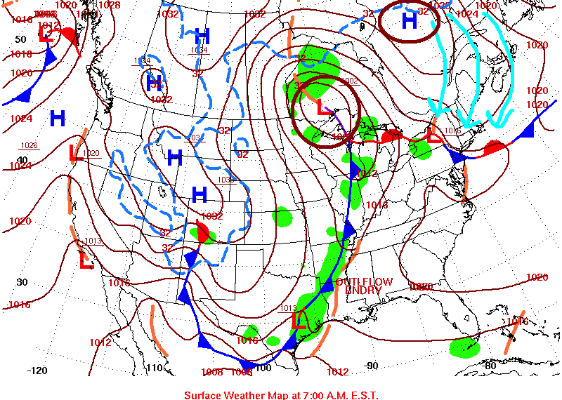
5/13/14 Daily Weather Map
By Tuesday the developing low pressure center has strengthened and moved north. As a result the high pressure center in Canada has strengthened as well and the cold air flowing south has pushed through Southern New England as evidenced by the movement of the frontal boundary from Northern New England to northern New Jersey. With current ocean temperatures in the Gulf of Maine in the upper 40s near 50 it is not surprising that our temperatures barely made it to the lower 50s on Tuesday with an east-northeast wind direction directly off the water.
To end I would like to share the station observation for Monday evening at Logan Airport which is the official observation location for the city. To help with the timeline, at the bottom 20:54 is approximately 5 pm Monday evening. At the top 03:54 is midnight Tuesday. It appears that the cold front passes Logan sometime between 7 and 8 pm Monday night. The temperature dropped 19 degrees from 74 to 55 between the hourly observations and more importantly the wind (3rd column from the left) changed from west at 9 knots to northeast at 28 knots with gusts to 38 knots. Thus ending the three day stretch of wonderful weather with highs in the 80s.

KBOS Observations
Be on the lookout the next time we have a stretch of real warm days, there is a change that the stretch might just be ended by a backdoor cold front.
-Chris
Yes the main reason for me creating this page was to create a place where I can publish my forecasts and to create an archive so that I will be able to review them in the future, but another big reason for me creating this page was so that I could create what I call my “Computer Guidance” page. (Found here) What it is is a page with a total of 102 computer links(guaranteed to increase) to various websites that all contribute something useful to either: making a forecast, analyzing the current conditions or looking back upon past events. Amazingly all 102 websites do serve a purpose(some serving many) and are all very useful and handy to use.
The reason for creating this page was simple: I wanted to give everyone an opportunity to find and utilize the many sources that I find useful when looking at and forecasting the weather. And my bookmarks tab couldn’t handle the volume of links that I was trying to save to it.
So for those of you reading who have no idea what any of the links possibly mean, and that is the majority of you, here are a few of the ones that I find simple and easy to use:
Southern New England Current Temperature Map Great for seeing what current temperatures are like around Southern New England
Continental United States Wind Map Basically just because it is cool to look at. But really what it does is give me an insight into where the surface features are located across the U.S.
College of Dupage Satellite and Radar Page My favorite site for viewing Satellite and Radar images and loops. Just follow the link, click on “1 km products”, choose visible or radar, then click the site you want to view. (click the one in southern Vermont) Then if you want to view a loop, at the top of the image are “visible image” and “radar mosaic”. Hover your mouse over them and a drop down box will appear, then simply choose how long of a loop you want to see.
Hydrometeorological Prediction Center Not my favorite site, but it is definitely the most user friendly. A simple way to look at and understand what is going on with our national weather. Simply click on which of the thumbnails you want to view and I’m sure you can figure it out from there.
After that, all of the links in some form or another are either a forecasting tool or a tool to analyze past events. Eventually I will go into further detail on what each link is useful for. Just need to figure out what is the best way to do that as there are so many of them.
-Chris
