After an impressively warm first three weeks of October, Mother Nature has decided that it is time for fall. This past weekend featured cool, crisp air and primarily sunny blue skies. However, this work week is one of clouds and rain with cold damp temperatures.
October Temperature Departures
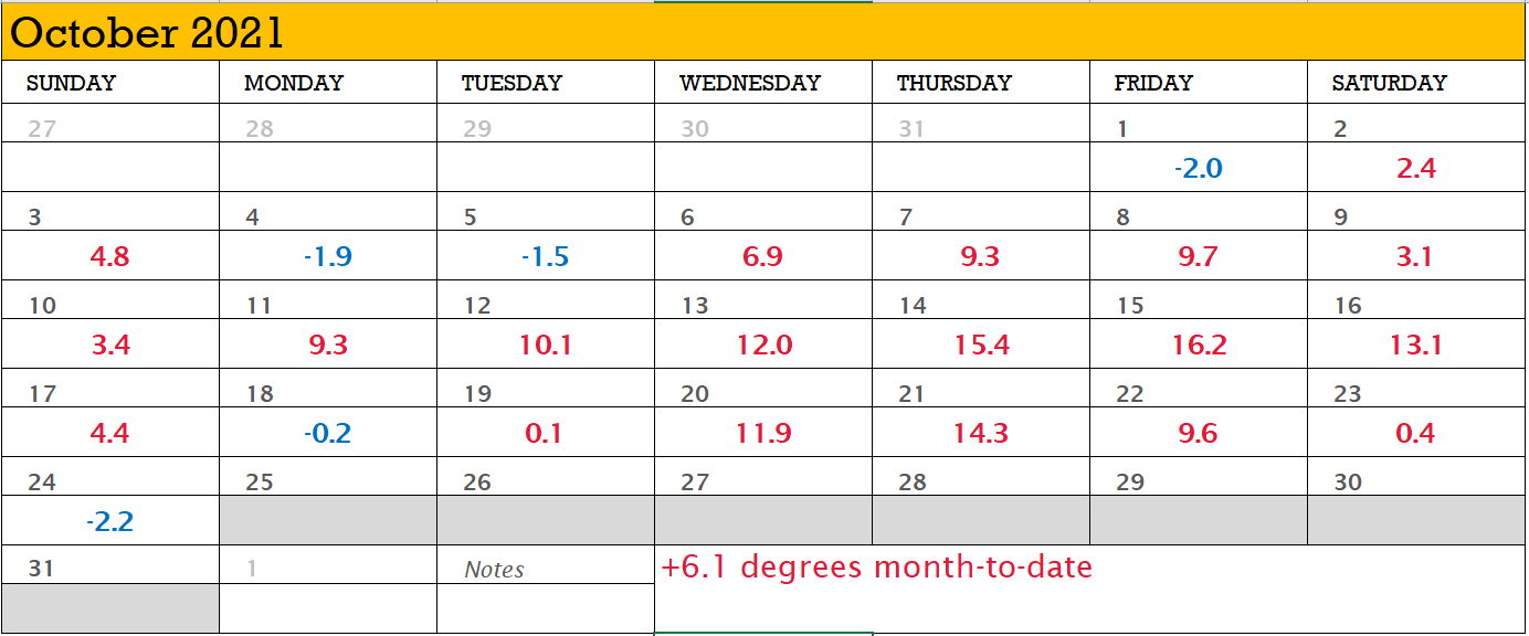
The weather station at Worcester, MA is running 6.1 degrees Fahrenheit above normal month-to-date with 19 of 24 days above normal! But that’s changing.
Nor’easter #1
The warmth that we’ve been experiencing has come to an end as the first nor’easter of the season is on our doorstep. Today’s cool and damp conditions will be followed by even more as a nor’easter moves in for Tuesday and Wednesday.
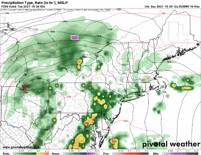
Above I’ve presented one computer guidance model’s interpretation of the storm systems progression over the next couple days. An area of low pressure will strengthen as it moves north along the east coast and will loop or stall briefly south of Long Island. The storm center itself will be quite strong with its atmospheric pressure bottoming out around 970 mb; potentially equivalent to a minimal hurricane in intensity.
With it, the storm will bring a prolonged period of rain and wind, coastal erosion and flooding, and cool-to-cold temperatures (relative to what we’ve experienced month-to-date).
Rainfall Potential
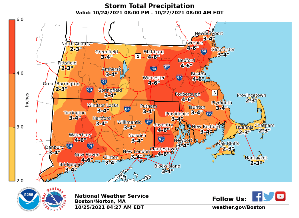
Storm total rainfall amounts on the order of 2-5″ are possible from the storm system. In terms of confidence in the forecasted amounts; greater confidence in the forecast the further south and east one resides. If you live further north and west, lower confidence in the amounts if the storm does not progress as far north as expected.
As a result of these forecast amounts, flood watches have been raised for the area.
Strong Winds
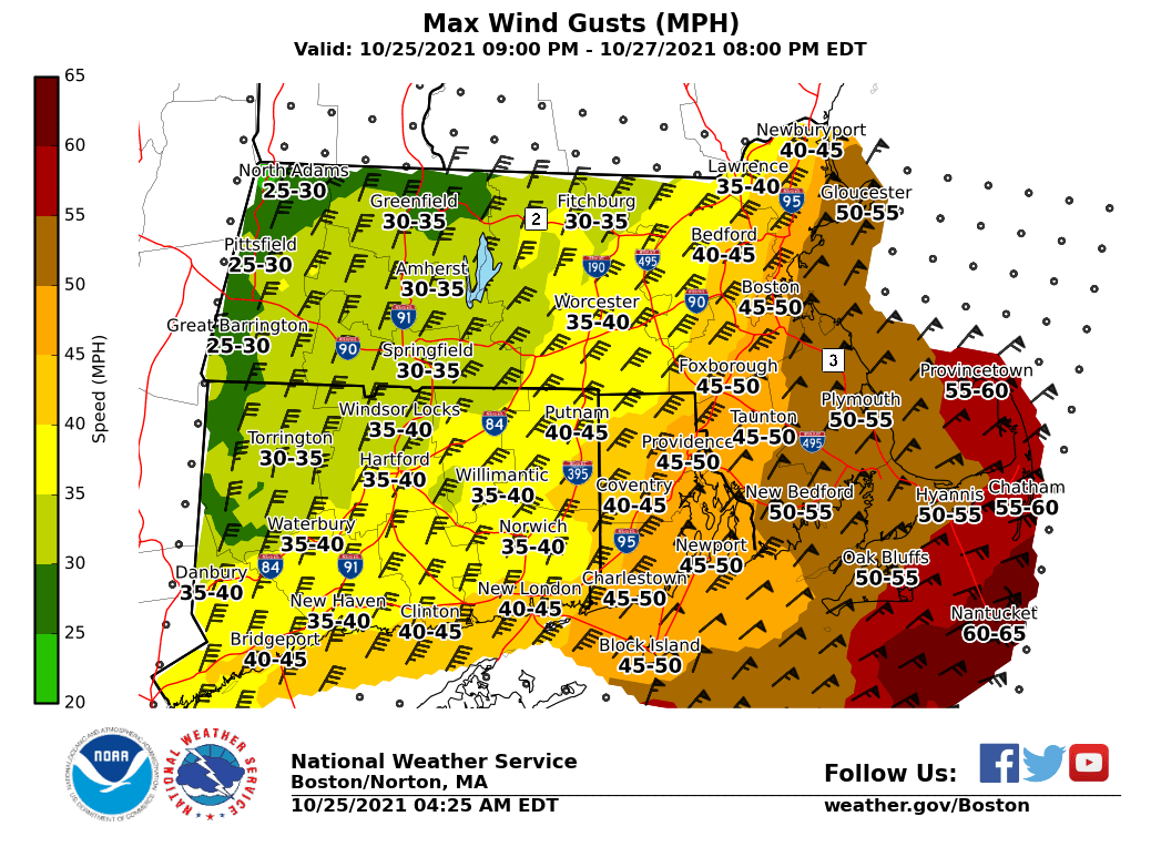
In response to the storms central pressure dropping into the low 970s, strong north and northeast winds will develop and overtake the region. Consistent with previous storms, the further one lives from the ocean, the lower the wind speeds and gusts will be. Those along the coast or inside of route 128 may experience winds greater than 50 mph. With trees primarily full of leaves and a soggy ground, power outages are possible. So best to be prepared.
Coastal Concerns
For those of you who live on the immediate coast and those flood prone areas (you know who you are), with a strong north, northeast fetch, coastal erosion and flooding concerns are moderate-to-high. Those areas that are prone to coastal flooding should expect issues.
Peek into the Future
The pattern across the eastern US is turning active. Tomorrow’s nor’easter appears to be the first in a series of storm systems to impact the east coast with additional storms possible both Halloween weekend and towards the end of next week.
-Chris
