The storm system that we’ve had our eyes on the last week or so will impact the region to start the workweek. Current bringing snow to areas of the Midwest a large, broad area of low pressure is drifting eastward along the Ohio River.
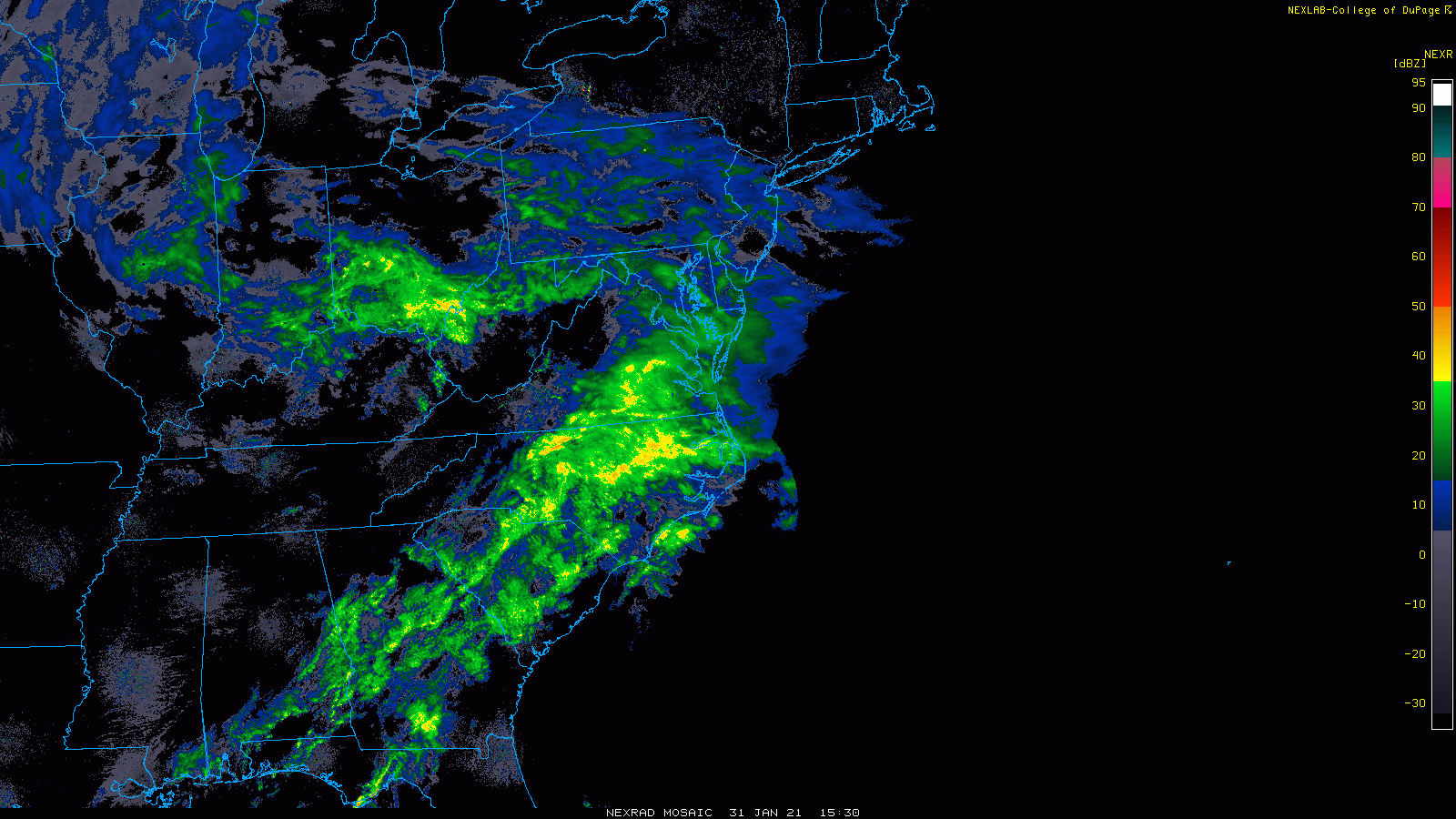
Of interest to New England is the plume of moisture lifting northward out of the Gulf of Mexico. By tomorrow morning a new area of low pressure will establish itself southeast of Atlantic City sending a moisture laden slug of precipitation northward into southern New England.

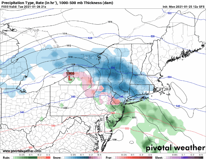
By 7 am tomorrow morning (above) snowfall is pushing ashore the Connecticut & Rhode Island coasts while a wall of moisture lurks to our south. During the day this wall of moisture will march steadily northward bringing with it a 12 hour “thump” of snow.
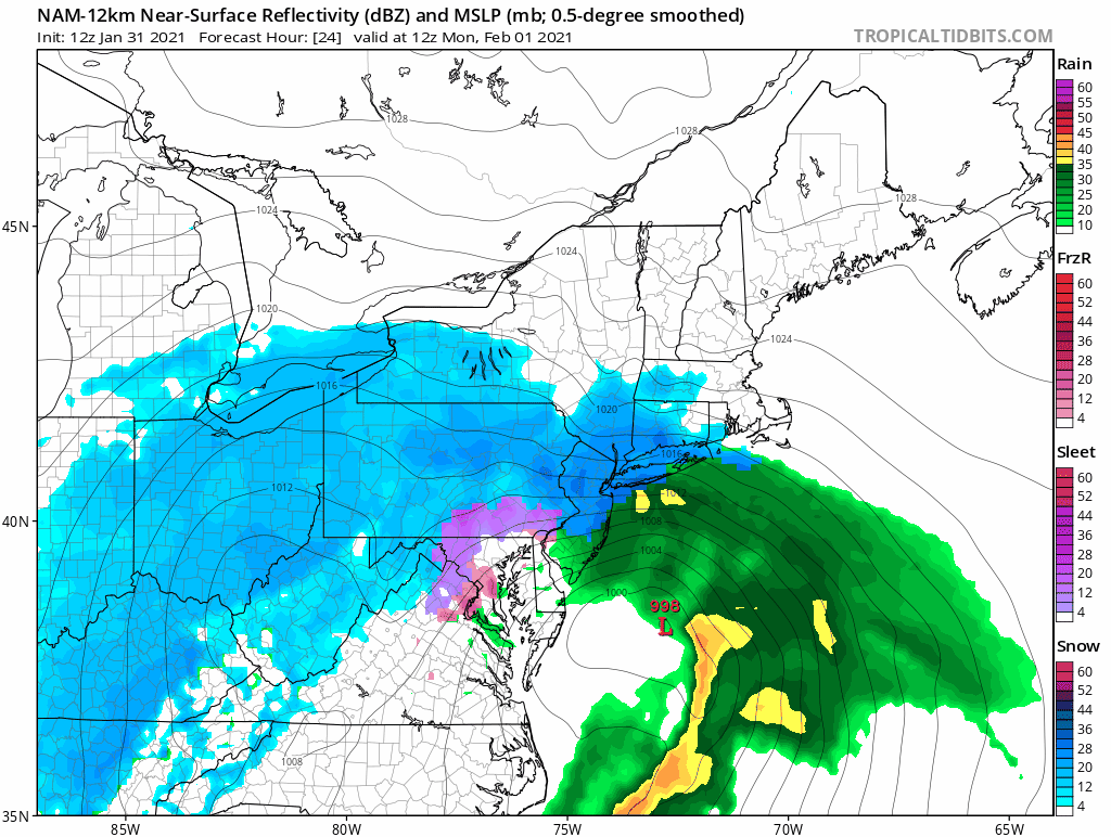
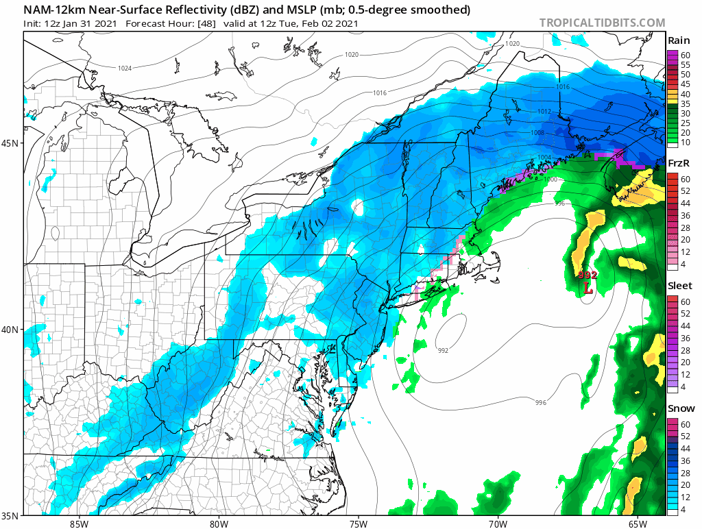
The above loop highlights the northward march of the precipitation shield. Most locations in southern New England receive a solid 10-12 hours of heavy snowfall with rates likely exceeding 1″ per hour. As day break on Tuesday approaches the low pressure system off the NJ coast will begin to lose its energy and a new low pressure center to the east of Cape Cod will take over. Which is why the focus of the heavier precipitation rates shifts northward into northern New England.
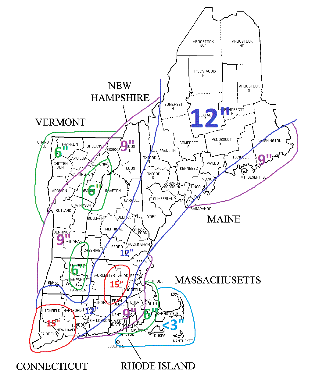
Cape Cod and the immediate Massachusetts coast lines will start as snow but flip over to rain fairly quickly on a strong easterly wind. Interior Plymouth and Bristol counties and southern Rhode Island will hold on the snow much longer and will only flip to rain as the intensity of the precipitation begins to let up.
Periods of light flurries and snow will still occur during the day Tuesday as the original storm system and upper atmospheric features drift by the region. The main accumulations are done at this point and what falls from the sky on Tuesday is more for the ambiance. A small resurgence of accumulating snowfall over Maine is possible overnight Tuesday into Wednesday, but that’s not set in stone.
-Chris
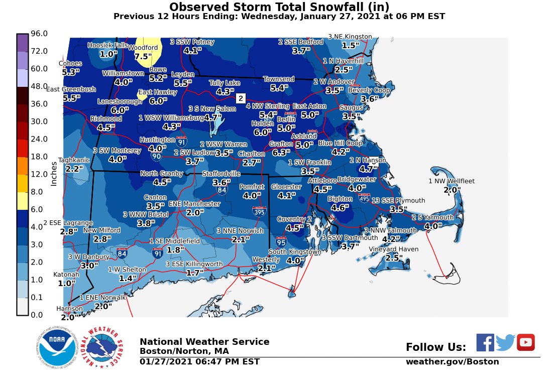
After nearly a month without snow in the air the last few days across southern New England have featured snowflakes quite a bit. Most accumulations occurred Tuesday evening where a general 3-5″ of snow fell most places.
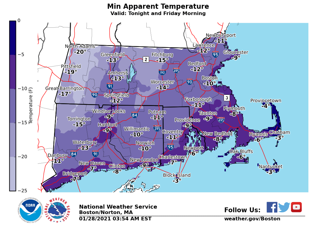
Just the right amount of snow to whiten up the landscape and make it feel like winter around these parts. And if the snow cover doesn’t make it feel like winter, then the blast of arctic air Friday and Saturday will.
Friday morning apparent temperatures, what we humans perceive the temperature to be, will be well below 0 F in most spots.
Fortunately this arctic shot doesn’t last too long and by Sunday afternoon temperatures return to a more traditional reading in the mid-20s.
At this point all eyes will be squarely focused a potential storm system for Monday afternoon and Tuesday. Weather model guidance continues to suggest that a storm system will pass southeast of the region and bring a period of accumulating snow. While the storm system is 4.5-5 days away, there is increased confidence of an impactful storm.
There is good ensemble agreement for an area of low pressure passing near the 40/70 benchmark Tuesday.
For a quick explanation of an ensemble forecast: https://www.metoffice.gov.uk/research/weather/ensemble-forecasting/what-is-an-ensemble-forecast
For a quick explanation of the 40/70 benchmark: https://nyskiblog.com/directory/weather-data/northeast-us/40-70-benchmark-map/
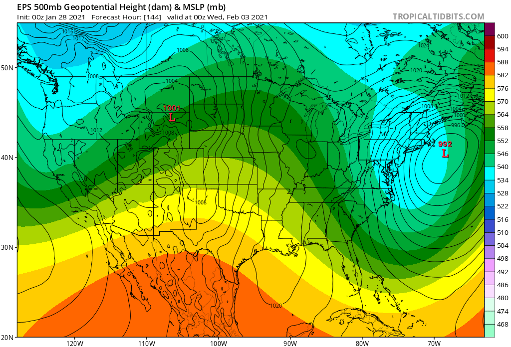
Presented below for illustrative purposes is the European forecast centers ensemble guidance for 7p Tuesday the 2nd. It presents a well defined low pressure center passing southeast of Nantucket. A good spot for a Northeast snowstorm.
For now it looks like a storm is likely for early next week. Finer details to be decided over the weekend.
-Chris
You’ve probably noticed that January 2021 has been quite boring in the weather department. It is quite difficult to remember such a dull, average month. Outside of a heavy rain event on January 16th, since January 2nd, only 1 other day featured a daily precipitation >0.1″ at the Worcester airport.
Speaking of the Worcester airport, as of January 25th, the observation site is running 6.2 degrees above average for the month and has only received 3.6″ of snow (compared to an average of 13.7″ for 1/1 to 1/25). In both departments, the next week should help to bring those values closer to normal (slightly).
A storm system that is bringing a foot of snow to Lincoln, NE today will drift eastward through the Ohio River Valley Tuesday/Wednesday and bring periods of light snow to the region.
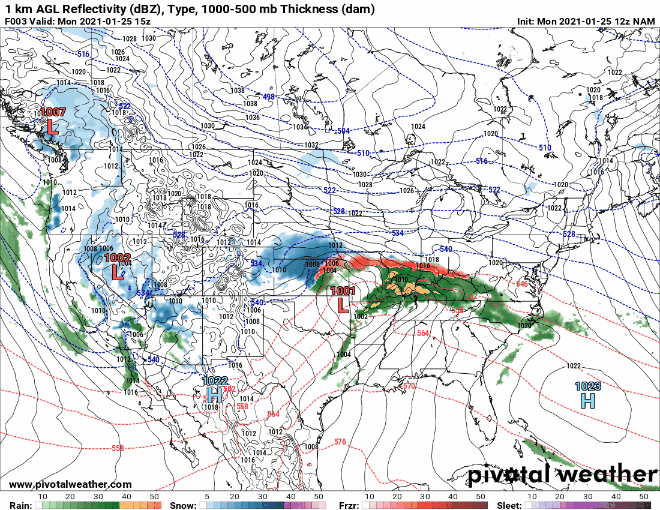
You’ve probably noticed that the storm system in question isn’t the most organized. In fact, it’s basically a hot mess. But even a hot mess can bring enough moisture to whiten the ground. Starting late Tuesday afternoon through pretty much the end of the week, periods of off and on light snow and flurries will occur.
The image above is a zoomed in view of the forecast from late Tuesday afternoon through Thursday morning. As for accumulations…well not too much. A general 1-3″ for the entire region should suffice in this instance.
If hoping for something a bit more significant in terms of snowfall, keep an eye on the February 1-3 timeframe. Many of the computer guidance models are hinting at something during this period.
-Chris
