Meteorological winter starts Sunday December 1st and guess what. Southern New England has a major winter storm coming for the Sunday PM – Tuesday AM time frame.
The Set Up
Last Tuesday an unusually strong storm system came ashore near the Oregon/California border. The storm system brought with it winds near hurricane strength and a maximum measured wind gust of 106 mph.
Click play on the loop below for a satellite loop of the storm coming approaching the west coast.

Atmospheric Energy Loop Tue PM – Friday PM – Pivotal Weather, LLC
After coming ashore near the Oregon/California border, the atmospheric energy (loop above) associated with the storm system has drifted south along the California coast and is now beginning to turn northward through the spine of the Rockies.
As a result an area of low pressure (blue) will form near Denver, Colorado this evening, strengthen and head northeast producing near blizzard conditions from Wyoming to Minnesota. A strong area of high pressure (red) in southern Canada will halt the storms northward movement and force it to slide eastward as shown by the loop below.

MSLP Loop – Pivotal Weather, LLC
As the storm approaches the east coast a new area of low pressure will form near Atlantic City and drift east-northeastward towards Nantucket. The storms progression south of SNE will be very slow, allowing for a long drawn out storm system.
The Storm

Sunday Morning – Pivotal Weather, LLC
As the slowly weakening upper-Midwest blizzard drifts across the southern Great Lakes Sunday morning, moisture laden Gulf of Mexico air will be drawn northward ahead of the system. At the same time cold Canadian air is pushed southward via the high pressure to the north.
This moisture rich air moves into SNE Sunday afternoon from southwest to northeast.

Sunday 7a -> Monday 1a – Pivotal Weather, LLC.
Precipitation rates Monday AM will lighten up in most areas as the new area of low pressure off the New Jersey coast begins to the strengthen. Places south of the Massachusetts turnpike may flip over to freezing drizzle or rain for most of the day Monday.

Monday 1a -> 7p – Pivotal Weather, LLC
Late Monday afternoon precipitation rates will pick up again for most locations as the surface low pressure strengthens and drifts eastward.

Monday 1p – Tuesday 1p – Pivotal Weather, LLC
Another round of heavier snow impacts SNE late Monday PM into the overnight hours. Light snow lingers into Tuesday morning, but by then accumulations are done.
Precipitation Types

Precipitation Type Forecast
First Call Snowfall Map

Snow Accumulation Sunday PM -> Tuesday AM
The ranges on the map above are bit wider than I would like. But with this storm system really consisting of two distinct periods of accumulating snowfall, I’m not confident yet in suggesting more exact amounts. I do think that someone in one of the 12″+ zones may end up somewhere in the 18-24″ range depending on how the storm unfolds.
Will likely have an update tomorrow.
-Chris
Incredibly, December 1st, which represents the start of Meteorological winter (Dec, Jan, Feb), is only a few days away. Winter is upon us and it is time to start thinking about what the winter of 2019-2020 might have in store for New England.
In order to develop an idea for what the winter season may bring in terms of snowfall, we’ll investigate the current state of the following:
- El-Nino Southern Oscillation (ENSO): El Nino, La Nina, or La Nada?
- Eurasian Snowpack
- Solar Cycle
- November Weather Pattern
- Long Range Modeling
When developing a seasonal forecast the goal is to identify the current (and future) atmospheric and oceanic patterns and relate those patterns to previous examples of similar patterns. This is known as developing an analog.
El-Nino Southern Oscillation
The Pacific ocean covers greater than 30% of the Earth’s surface. It’s impact on the Earth system as a whole is significant simply due to its size. The pacific ocean sea surface temperature pattern can have a significant impact on the atmosphere around the globe but particularly the North American continent. You may be familiar with the term El Nino. An El Nino occurs when there is a build up of abnormally warm water along the equator in the Pacific ocean. The opposite, abnormally cold water, is a La Nina. Anything in between, classified as neutral, is commonly referred to as a La Nada, meaning that surface water temperatures along the equator are neither abnormally warm or cold.

Oceanic Nino Index – CPC
The current ENSO mode is that of a La Nada. Three month average surface water temperatures have been 0.1 C above normal for 2 months in a row. To classify as an El Nino, values must be greater than 0.5 C. Less than -0.5 C for La Nina.
Computer projections for the state of the ENSO for the winter continue the theme of near normal sea surface temperatures. Hovering somewhere between 0.1-0.3 C above normal.

ENSO Model Projections
So what does the typical ENSO neutral atmospheric pattern look like?

ENSO Neutral Atmospheric Pattern
The typical La Nada winter-time pattern for the North American continent is shown above. A battle ground between cold air intruding southward from Canada and warm air lifting up from the Pacific and Gulf of Mexico is created over the eastern half of the U.S. where the jet streams tend to combine. This leads to increased storminess for the east coast.
When looking for potential analog years, I used a range of -0.3 – 0.3 C ENSO ONI values for DJF & JFM. The following were identified as analog years. I’ve included the Boston, MA seasonal snowfall for those years. For reference, the long-term average Boston seasonal snow total is 43.8″.

ENSO ONI Analogs & Boston Snow
Eurasian Snow Cover

Eurasian Snow Cover – NOAA
Recent analysis by Dr. Judah Cohen has connected Eurasian snow cover extent during the fall months with the probability of cold outbreaks across the northern hemisphere. October snow cover was above average this year, but has fallen back to near average during November. I’m not sure that any significant conclusions can be deduced with things near average. Perhaps lean cold since October was above average.
Solar Cycle
Did you know that the sun’s energy output is on a cycle? An 11-year cycle to be exact. This cycle is observed by monitoring the number of sun spots on the sun’s surface.

Solar Cycle Example
Currently, the sun is nearing the minimum of solar cycle 24. Research has shown that during the minimum periods there is an increased probability of high latitude atmospheric blocking. This blocking regime is conducive for slow moving storm systems.
November Weather Pattern
Interestingly enough there is a connection between New England’s November temperature departure and a winter’s snowfall total. Below is the analysis performed for Boston.

November Temperature Correlates to Boston Snowfall
Since 2000 only two times did the November rule not work: winter 2000-01 & 2018-19. Meaning there is a high probability of above average snowfall following a November with below average temperatures and vice versa. So, was it cold or warm this November?
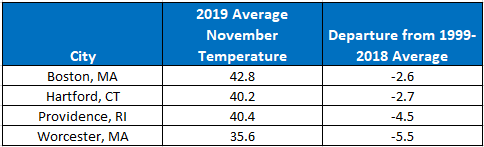
November 2019 Temperature Departures
It’s been pretty cold across Southern New England this month. Based on the November rule, there is a high probability of above average snowfall this DJFM.
Long Range Modeling
A lot of money is spent attempting to simulate the atmosphere and model future outcomes. Computer models are run for various time periods, including seasons. Below are two model simulations for precipitation anomaly forecasts (DJF & JFM). Both highlight that this model is expecting above normal precipitation for the eastern third of the U.S. Particularly for the second half of winter.

ECMWF DJF Precipitation Anomaly – WeatherBell, LLC

ECMWF JFM Precipitation Anomaly – WeatherBell, LLC
Conclusion

Snow Lovers Rejoice
Last year I expected New England to receive slightly above normal snowfall. Unfortunately that didn’t happen in Southern New England as Central & Northern New England ended up with all of the snow. I’m doubling down this year. Based on the information documented above, I’m expecting above average snowfall, particularly in January and February. The neutral ENSO state combined with the solar cycle and November rule, sprinkled with Eurasian snow cover and long range modeling all point towards above normal snow for Southern New England.
-Chris
Depending on who you ask, it is said that the Wednesday before Thanksgiving is the busiest travel day of the year. Whether you are flying home, driving to Grandma’s house or running to the store because you forgot gravy, odds are that at some point this week, you will travel somewhere.
As you prepare for your travel this week, ensuring that you do so safely is imperative and nothing has the ability to disrupt the best laid travel plans like the weather does. So what does this holiday week entail?
Monday the 25th

Monday – Pivotal Weather, LLC
Monday is fairly quiet across much of the lower 48. The storm system that impacted New England on Sunday lifts northeast into maritime Canada. A weak storm brings a sprinkle or flurry to northern Minnesota and the Lake Superior area. Across the Rocky Mountains, a storm system is beginning to form between Salt Lake City and Denver.
Tuesday the 26th

Tuesday – Pivotal Weather, LLC
Two significant storm systems make their presence known on Tuesday. The first being the low pressure moving east from the Denver area. This system is a typical high plains winter storm. Showers/thunderstorms to the south and east in the warm sector. Blowing snow with potential blizzard conditions to the north and west. Places from Denver to Minneapolis could pick up 6-12″ of snow.
The second storm is a strong area of low pressure coming ashore along the Oregon coastline. Heavy rain and strong winds will impact the lower elevations, while heavy snow will fall in the mountains. From the National Weather Service in Medford, Oregon:
A highly unusual, rapidly deepening Pacific storm system is
expected to make landfall on the southern Oregon coast Tuesday
evening. This surface low pressure, potentially one of the
deepest recorded in recent memory, will produce very strong winds
across the region, particularly at the coast, over the area
ridgelines, and in the valleys of Josephine, Jackson, and
Siskiyou counties. Everyone in the affected area should be
prepared for potentially damaging winds.
Wednesday the 27th

Wednesday – Pivotal Weather, LLC
The storm system that brought near blizzard conditions from Denver to Minneapolis on Tuesday continues to drift northward through the Great Lakes, weakening as it progresses. Rain/snow will shift northeastward through the Mid-Atlantic and New England states.
The abnormally strong storm system along the west coast moves into the Rockies bringing snow to many locations. As it does, this storm will draw eastern Pacific moisture northward into the four corners and west Texas region.
Thursday the 28th

Thursday – Pivotal Weather, LLC
Storm number 1 exits stage right into the northwest Atlantic. Thursday should be quite windy across eastern New England on the backside of that storm. Storm number 2 continues to spin over the Rockies. The Pacific moisture that was drawn northward Wednesday brings a period of rain/snow to the plains states.
Friday the 29th

Friday – Pivotal Weather, LLC
Storm number 2 final gets a move on and heads north towards the Dakotas. Another classic great plains winter storm system. Showers/thunderstorms on the south and east side, with heavy, blowing snow on the north and west side of the low. Strong high pressure in southern Canada will prevent this storm from gaining much latitude and force it to slide east along the northern U.S.
Saturday the 30th

Saturday – Pivotal Weather, LLC
Strong Canadian high pressure causes the northern plains blizzard to stall and drift eastward. Rain/snow and everything in between shifts eastward through the Great Lakes and towards the northeast.
Another storm system brings unsettled weather to the west coast. Much needed rain/snow for California.
Sunday the 1st

Sunday – Pivotal Weather, LLC
Unsettled weather continues for California, while the energy from the Plains blizzard shifts eastward and brings rain/snow to the New England area.
All in all a busy week in the weather department with multiple storms impacting the west coast and plains states. The eastern U.S. will feel the effects from these storms eventually, but in reality, eastern areas get the leftovers.
Have a happy and safe Thanksgiving.
-Chris
Anyone else noticed how cold it has been this month? Average temperatures are running 3-9 degrees Fahrenheit below normal this month across most of Southern New England.

U.S. Month-to-Date Temperature Departures
From the image above, the eastern 2/3 of the continental U.S. is running well behind schedule this month so far. It’s been cold, there’s no denying that.
Annoyingly for snow lovers, the atmospheric pattern hasn’t worked out. There is very little snow cover south of the U.S./Canadian border.

Northern Hemisphere Snow Cover
Although the mountains of northern New England are doing ok as this weekend is opening weekend for many of the local ski resorts.

MSLP & Precipitation – Pivotal Weather, LLC.
Sunday evening an area of low pressure will form off the coast near Atlantic City and track northeast south of the Cape & Islands. Now traditionally this is a favorable storm track for snow in Southern New England. Unfortunately, there just isn’t a good supply of cold air for that to happen.

925 mb Temperatures – Pivotal Weather, LLC.
Shown above are forecast temperatures only a couple thousand feet above the surface. Anything warmer than a blue shading is a temperature greater than freezing. As is obvious, there’s very little in the way of cold air to support snow.
Eventually on the northern fringes of the precipitation shield, enough cold air may be injected into the system for snow to fall. But that will be challenging to forecast. Very little if any accumulation is expected for those areas that do flip to flakes.
Looking ahead to the holiday next week there is the potential for a storm system to move through during the Wednesday/Thursday time frame. This is still 5+ days out, but this one looks warm.

Wednesday PM – Pivotal Weather, LLC
-Chris
Good morning all! Everyone’s favorite four letter word made it into the forecast these past couple of days. Yes it is true, your favorite local TV meteorologist likely said the S word yesterday. Hopefully their use of the word snow came with caveats regarding storm track, arrival of cold air, and other uncertainties. Because to be honest, I’m not confident in accumulations south of the NH/VT border away from the elevated terrain of the Worcester hills.

ECMWF Precipitation – Pivotal Weather, LLC
The above forecast loop starts Thursday morning and ends Friday afternoon. A weak are of low pressure riding along a frontal boundary brings with it a 12 hr period of precipitation. Temperatures to the north of this boundary are cold enough to support snow. Rain or a mix of rain & snow will occur along and south of the boundary.
As for accumulations, I’m not confident enough to put numbers on a map. I do think that the ski resorts of northern New England have a good shot at 6 inches or more. I do have enough confidence in expected precipitation type with the system as shown below. The purple and orange outlines, and adjacent blue and green areas are the locations where confidence is lacking. Currently, there is a bit of unknown with regards to the location of the frontal boundary and the rain/snow line.

Anticipated Precipitation Types
This storm system for Thursday night into Friday morning is likely not the regions only chance of snow over the next couple of weeks. The next couple of weeks will feature below normal temperatures as highlighted by the 8-14 day temperature probability forecast from the Climate Prediction Center. The below graphic shows that there is a high probability for below normal temperatures east of the Rockies.

8-14 Day Temperature Probability – CPC
The period to watch for the next potential snow threat is around mid-week next week. However, that is an eternity away in terms of weather prediction, but just something to keep an eye out for.
I’ll continue to keep my eye on the Thu night/Friday morning system and update the forecast as things become more clearly defined.
-Chris
