Good evening all and happy Friday! For you skiers, this storm could not be more perfectly timed. A long holiday weekend and a foot of fresh powder on its way. For you teachers….I’m sorry.

Mid-Level Water Vapor Loop Friday Evening – College of DuPage
Above is a water vapor loop for this evening. A water vapor look is just as it sounds. A 22,000 mile high view of the moisture in the atmosphere. Yellows indicate drier air while whites and greens indicate moisture rich air. The mass of white and green swirling in the middle of the screen is our storm system for Saturday night and Sunday.
Note: the northward flow of moisture from the Gulf of Mexico. The storm is tapping into moisture rich air.
The below image from the Weather Prediction Center shows the storms progression from west to east across the country.

Low Pressure Track – WPC
Saturday
Throughout the day Saturday the storm center will travel northeast from the southern Plains states to the Mid-Atlantic. As it continues to gather Gulf of Mexico moisture, the storms precipitation field will expand tremendously.

Saturday Storm Progression – Tropical Tidbits
The above forecast loop starts 1 am Saturday morning and ends 1 am Sunday morning. Snow overspreads the region from west to east after dinnertime Saturday night. For an estimate of when the first flakes will begin to fly, here is a forecast from the National Weather Service in Norton, MA.

Snowfall Start Time – NWS
Saturday Night & Sunday
Overnight Saturday and into Sunday morning is when the bulk of the precipitation falls. Snowfall rates on the order of 1-3″/hr are possible. Travel is likely very difficult as snow removal crews struggle to keep up.

Saturday Night & Sunday Storm Progression – Tropical Tidbits
The above forecast map starts 7 pm Saturday and ends 1 am Monday morning. All locations starts as snow. Slowly but surely warmer air aloft works it way in flipping locals south of the Massachusetts turnpike and inside of Route 495 to sleet and freezing rain. Places out along Route 2 in northern Mass may even flip to sleet for a time. Locations south and east of Interstate 95 like flip to rain for a period. Far southeastern MA, Rhode Island, Cape & Islands flip to rain for an extended period.
Precipitation Type Forecast

Precipitation Type Forecast
Blue: All Snow
Red: Mainly Snow -> Sleet -> Ice -> Snow
Orange: Snow -> Sleet -> Ice -> Rain -> Snow
Green: Snow -> Sleet -> Rain -> Snow
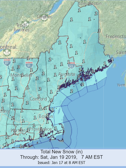
Snowfall

Expected Snowfall
Ice Accumulation
Another aspect to this system is the potential for significant icing to accumulate during the transition period early Sunday morning. Temperatures below freezing are likely to be locked in at the surface while temperatures aloft warm above freezing. This allows for precipitation to fall as sleet and freezing rain. For potential ice accretion amounts, I will turn to the experts at the National Weather Service.

Ice Accumulation Forecast – NWS
Sunday Night – Total Lunar Eclipse
If the clouds clear out Sunday night, then we will be able to witness the only total lunar eclipse of 2019. Named the “Super Blood Wolf Moon”, starting around 10:30 pm, if visible, the moon should begin to darken. Between 11:40 pm and 12:40 am, the moon will be totally eclipsed by the Earth’s shadow. For a look at how a lunar eclipse occurs:

Lunar Eclipse Mechanics
Monday
Monday morning will likely feature the coldest air of the season with low temperatures in the single digits to near or below zero. Fortunately the kids don’t have to go to the bus stop, but for those still digging out from the storm, it will be dangerously cold. Stay warm!

Monday AM Low Temperatures – WeatherBELL
Long Range
Another storm is possible towards the end of next week. Right now, that system looks warmer than this one, but there is plenty of time to sort the out details.

EPS Ensemble Mean – PivotalWeather
-Chris
Exciting times ahead as we quickly approach this holiday weekend. An appetizer system moves through Friday, followed by the main course Sunday and for dessert on Monday, near zero temperatures. Let’s get right to it!
Below is a water vapor loop showing the current atmospheric pattern over most of the North American continent. Friday’s storm system is slowly organizing over southern Illinois, Indiana and Kentucky as it pushes east through the Ohio River valley. Looking a bit further west, Sunday’s storm is coming ashore along the northern California coastline. Note the key contrast between the two….which one looks more impressive? Hopefully you picked Sunday.

Thursday Morning Satellite – College of DuPage
Friday
Friday’s system fails to organize very well and is starved for moisture as it traverses the northeast. A light round of snow and rain will impact the region and potentially the Friday AM commute. Note: Sunday’s system is forming lee of the Rocky Mountains, even in its infant stages, it is already much more impressive than Friday.

Friday System Progression
I’m going to lean on the fine folks at the National Weather Service for the snowfall forecast. Friday’s storm is the appetizer anyway and let’s be real, appetizers are an afterthought when you’ve ordered prime rib for the main course.
Friday Snowfall – National Weather Service
Saturday
As Friday’s system departs, arctic high pressure will drop in from the northwest. This will act to establish a fresh supply of cold air. A cold air mass is much more stubborn and is very difficult to move. This will be key to the forecast for Sunday.
In the image below, high pressure drops in from Hudson’s Bay as low pressure organizes in the southern states.

Arctic High Pressure Moves In – WeatherBELL
As the system moves from west to east across the southern half of the United States, it will draw north a significant plume of Gulf of Mexico moisture. The loop below highlights available moisture in the atmosphere. Note how the plume of dark greens and blues is drawn north and makes its way all the way into southern New England.

Storm System Gather Moisture – PivotalWeather
Saturday Night -> Sunday

Saturday Night/Sunday Storm Progression – PivotalWeather
Snowfall will overspread the region from southwest to northeast during the evening hours Saturday night as the low pressure center moves through the Ohio River valley and off the New Jersey coastline. All locations start as snow.
During the early morning hours on Sunday, warmer air from the south will try to move in to New England. It’s progress will be slow as the cold air being reinforced by the arctic high pressure will put up a fight. Surface temperatures will likely stay below freezing longer than the air aloft; at or above 5,000 ft. Meaning that the snow will transition to sleet or freezing rain for a time. Eventually those locations in southern Connecticut, Rhode Island, and southeast Massachusetts will warm above freezing at the surface and transition to rain.
In terms of the progression of precipitation type during the storm, here is my current thinking:

Precipitation Type Forecast
Blue: All Snow
Red: Mainly Snow -> Sleet -> Ice -> Snow
Orange: Snow -> Sleet -> Ice -> Rain -> Snow
Green: Snow -> Sleet -> Rain -> Snow
Ok. Time for the main course. In terms of accumulated snowfall, here is what I am currently expecting:

Snowfall Forecast
Being that we are still 2-3 days away from the meat of the event, I’ve opted to paint a broader brush than usual. Small iterations in storm track could lend to large swings in ranges, particularly in southern New England. Compared to my counterparts at the National Weather Service, who continue to perform exemplary work despite the government shutdown, I may be a bit conservative.

National Weather Service Snowfall Forecast
Within that battle zone between cold air and warm, there is the chance for significant sleet & freezing rain to occur. This will likely fall on top of 6-12″ of snow, so the snow pack will develop a thick crust. Please be careful.

National Weather Service Ice Forecast
Monday
And on this weekends menu for dessert, near zero temperatures for Monday. Shoveling out Monday will likely not be the most enjoyable task ever. In addition to the foot of snow, temperatures near zero with wind chills even colder than that.

Surface Temperatures Monday AM – WeatherBELL
Update to forecast likely again tomorrow!
-Chris
Hi all! It seems like forever since there was actually snow in the forecast because well it has been. The regions last significant snowfall occurred back in mid-November. Now a full two months later and we’ve yet to see another snow “storm”. Sure there have been the occassional round of snow squalls and flurries, but a legitimate storm that required the plow trucks has escaped us for a long time now.
That’s not to say that there hasn’t been snow around. In fact many places to our south, particularly down in Virginia and North Carolina have received more snow than we have. Finally after two months of waiting, it seems the overall atmospheric pattern is beginning to adjust into a more favorable setup for Southern New England (SNE) snowfall events.
Friday
The first of which occurs Friday. As a weak storm system drops east out of the Rocky Mountains and moves our direction. While this storm won’t bring substantial totals in any way, it will be the most snow we have seen since November.

Friday Storm Progression – Tropical Tidbits
The above loop begins Thursday afternoon and ends overnight Friday into Saturday. As shown a weak area of low pressure moves out of the Ohio River Valley and tracks northeast across SNE. It brings with it a light batch of rain and snow. Right now, those places north and west of Route 495 and north of the Mass Pike have the best shot at staying all snow, but the rain/snow line may progress to the MA/NH border Friday morning.

Friday Potential Snowfall
Saturday
Following Friday’s light snowfall, temperatures will be quite chilly. Morning lows in the single digits and teens for many will give way to high temperatures in the upper teens and twenties across the region.

Saturday Afternoon High Temperatures – WeatherBELL
SUNDAY
Late Friday as our first storm system is exiting to the northeast, our next one will begin its trek along a similar path. Dropping out of the Rockies and sweeping across the nation, this storm will gather significantly more Gulf of Mexico moisture. Moving northeast out of the Ohio River Valley the storm center will likely traverse across SNE. With this potential storm track, all precipitation types (snow, sleet, ice, rain) are on the table as evidenced by the variety of colors in the loops below.

Sunday Storm Progression – Tropical Tidbits
The above loop begins Friday evening and ends Monday morning.

Sunday Storm Progression – Tropical Tidbits
The above loop begins Saturday afternoon and ends Monday morning.
As always when there is a forecast involving the rain/ice/sleet/snow line, a myriad of factors are at play that ultimately determines who sees what types of precipitation. Right now, here is my best guess as what forms of precipitation locations can expect. Very much subject to change over the coming days.

Sunday Precipitation Type Forecast
Important notes to go along with current precipitation type thoughts:
- Where it stays all snow, upwards of 12″ is possible;
- The areas in red:
- Potential for upwards of 6″ of snow;
- Followed by a firm crust of sleet;
- On top of which significant icing, >0.25″, is possible.
- The area in green:
- Potential for plowable snowfall;
- Followed by a change to sleet & ice;
- Transitioning to rain for a time.
- The area in purple: a few inches of snow transitions to rain.
- All areas likely end as a bit of snow. A couple additional inches are possible.
Also, the specifics of the forecast are very likely to change. This system will be fascinating to watch unfold, but will be very tricky to forecast.
Long Range
In the extended, a long wave atmospheric pattern of lower pressure across the eastern half of the North American continent will lead to increased changes of storminess. The second half of winter should certainly produce more snow than the first. Whether or not we will see the slightly above average snowfall in SNE that I originally predicted is tough to tell at the moment. We shall wait and see.

ECMWF Ens 500 mb Heights – Tropical Tidbits
-Chris
