Good afternoon all! We have a little taste of winter on the way for Thursday and overnight into Friday morning. The first thing you might notice tomorrow is just how cold it is going to be for the morning ride to work or the bus stop. Below is a look at what the air temperature could look like tomorrow AM courtesy of the National Weather Service office in Norton, MA. It would not surprise me to see some locations even lower.
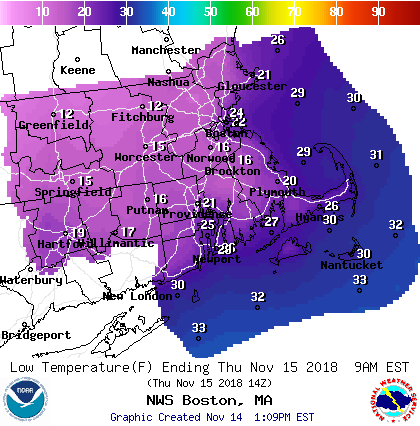
11/15/18 Morning Low Temperatures – NWS BOS
These low temperatures will allow for our next storm system, currently organizing over the southeast, to start as snow for most locations. Watch the loop below for how the storm coverage, particularly over Alabama, increases rapidly. A sign that a lot of moisture will be available as the system tracks northeast.

Southeast Regional Radar – 3 pm Wednesday – COD
TIMELINE
5 pm Thursday Evening: Snow will make its way into Southern New England from southwest to northeast during the evening hours Thursday. Southwest Connecticut gets in on the act first. The evening commute for the Boston metro area looks ok.

5 pm Thursday Evening – Tropical Tidbits
10 pm Thursday Night: Snow has overspread the region and is falling at a pretty good clip; upwards of an inch an hour. This system will really feature a front end thump as most of the snow falls during the first half of the storm system. Warmer air aloft and along the coast lines and southeast Massachusetts/Rhode Island will work its way in and eventually flip snow to rain.

10 pm Thursday Night – Tropical Tidbits
3 am Friday Morning: Very early Friday morning warm air should flip snow to rain for most locations inside of rte 495 and south of I-90. The hills of Worcester county and the Berkshires will fight to stay as snow or sleet for a while. Also around this time we will have to pay attention to an area of dry air moving in aloft. This should act to shut off the heavier precipitation as things will become more spotty in nature.

3 am Friday Morning – Tropical Tidbits
The next image highlights the potential for dry air (brown) to move in aloft and put a halt to the heaviest precipitation.

700 mb Relative Humidity – WeatherBell
9 am Friday Morning: Precipitation rates may pick up again for a time Friday morning as the storm center passes over the region. Some locations could flip back to snow for a period. IF things break right, there could be a 2-4 hour window of heavy precipitation during the late morning hours. Something to watch for.

9 am Friday Morning – Tropical Tidbits
1 pm Friday Afternoon: By early afternoon the storm system has moved off to the northeast and precipitation has quieted down across Southern New England.

1 pm Friday Afternoon – Tropical Tidbits
SNOWFALL

Snowfall
-Chris
