Note: based on information presented on 11/15/18.
For the last few years, on the Thursday prior to Thanksgiving, I have given a presentation at work regarding my expectations for the upcoming winter. Previously I had not taken the time to blog my thoughts, but this year I have decided to do just that. So, without too much hoopla, here are my thoughts regarding Winter 2018-2019 in the Boston area.
I suppose the first question that needs to be addressed is: how exactly does one develop a seasonal forecast? It is true that there are weather models that predict seasons at a time, but models have their limitations (too many to list here). Perhaps the best avenue is to attempt to correlate the current state of the climate with years past and develop expectations for this upcoming winter season. To develop those expectations, I am going to rely heavily on the current state of the El Nino-Southern Oscillation (more commonly known as simply El Nino), the Northern Hemisphere snow pack, the solar cycle and I’ll throw in a seasonal model forecast or two.
El Nino-Southern Oscillation (ENSO)
ENSO refers to a recurring climate pattern across the equatorial Pacific Ocean. El Nino and La Nina are the warm and cool phases of the pattern that exhibit themselves by either warmer or cooler than average sea surface temperatures across the Pacific Ocean, especially along/near the equator. Each ENSO phase produces mostly predictable disruptions of temperature, precipitation, and wind patterns across the globe.
The U.S. Climate Prediction Center has issued an El Nino Watch and is expecting that an El Nino will form and persist through the Northern Hemisphere winter and into spring.
So, what does a traditional wintertime El Nino pattern look like for the U.S.?

North American Wintertime El Nino Pattern
A typical wintertime El Nino pattern for the U.S. features an active southern jet stream (red arrow) that helps to bring an influx of Pacific moisture to the southern states. The polar jet stream often times gets in on the act as well by delivering shots of arctic air to the Midwest and Northeast. Should these two jet streams sync up over the eastern two-thirds of the continent, then an active and snowy pattern is possible.
Model projections for the strength of the El Nino project a three month average sea surface temperature departure of around +1 degree Celsius for December, January, & February with a slight weakening heading into spring.

El Nino Forecast
Searching the archives for past El Nino occurrences with a DJF SST anomaly of approximately +1 degree Celsius, that coincided with a slight weakening for JFM produced five potential analogues. Presented below are those identified seasons and the snowfall observed in Boston. The 2019 values are based on my interpretation of the model forecast above. Also, for reference, Boston averages 43.7″ of snow per year.

A deeper analysis will be required to determine what happened in 1995, but even including that season produces an above average snowfall total for the area.
North Hemisphere Snow Pack
With an establishing El Nino predicted for this upcoming winter, there should be an abundance of moisture available for storm systems traversing the continent to tap into. But will there be enough cold air around for these storms to produce snow? To answer that question, let’s take a look at the state of snow coverage in the Northern Hemisphere.
As of November 11th, the total area of the Northern Hemisphere that is covered by snow is near the top when compared to the past 14 years. What this tells me is that there is cold air available across much of the top half of the planet.

Northern Hemisphere Snow Cover
Particularly when looking at North America, where snow cover is on par with the winter of 2014-2015. And if you were in Boston during February 2015, you need not be reminded of what happened that year.

North American Snow Cover
And to add a visual to how much of the hemisphere is covered, any area covered beige below had snow cover on November 14th.

Northern Hemisphere Snow Cover
Solar Cycle
Did you know that the Sun is on a cycle? The amount of magnetic flux (energy) that rises to the Sun’s surface varies with time; known as a solar cycle (lasting approximately 11 years). Probably more commonly known as the sunspot cycle since sun spots represent areas of high magnetic flux and can be quite visible.

Solar Cycles
The sun is currently nearing the minimum of solar cycle 24 (since 1755). Research suggests that the slight decrease in solar energy increases the potential for the polar vortex to be disrupted and for outbreaks of arctic cold to drop south out of the high latitudes.
To prove that sunspots are at a minimum, below is the sunspot image from the 3rd week of November with nary a spot to be found.
(found here: https://www.spaceweatherlive.com/en/solar-activity/sunspot-regions)
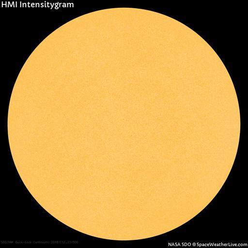
Current Solar Image
Model Seasonal Forecast
Millions of dollars are spent annually to improve weather prediction models. So it would be rude to not acknowledge them. Below are a pair of images showing temperature and precipitation anomalies as predicted by the November 14th model run of the National Center of Environmental Prediction’s Climate Forecast System model.

CFS Temperature Anomaly December -> February

CFS Precipitation Anomaly December -> February
This model run for the winter months forecasts below normal temperatures for Southern New England with average precipitation.
Summary
In summary, for Winter 2018-2019 I am expecting average temperatures (leaning slightly below) with above average snowfall; 50-55″ for Boston (15-25% above normal). The signal for increased moisture from the developing El Nino and available cold do to a robust Northern Hemisphere snow pack are too big to ignore and I’m expecting a snowy winter around these parts.
-Chris
Hello all! Hope you had a lovely Thanksgiving holiday break. As has been the pattern for what seems like two months now, there is another storm in the forecast for tonight. Tonight’s system will bring a wind swept rain to Southern New England and upwards of 1′ of snow to Northern New England. For you skiers, ski country has been cleaning up this fall and looks primed for an excellent winter season.

Monday 11 AM Radar – College of DuPage
Low pressure near Cleveland, Ohio that recently brought Blizzard conditions to parts of the Great Plains and Midwest is drifting northeast along the shores of Lake Erie. Ahead of the system, southerly winds are advecting moisture northward through the Mid-Atlantic and into the Northeast. Temperatures across the Mid-Atlantic, Upstate New York & Southern New England are too warm for snow, but eventually, moisture will make its way to central and northern Vermont, New Hampshire and Maine and fall as snow.
TIMELINE
In Southern New England, it is going to be a close call with regards to the evening commute tonight. The further northeast one resides, the better your chances for your commute not being impacted too badly. By 8 pm, rain has overspread much of the region and snow is beginning to fall in central New England.

8 PM Monday Evening – Tropical Tidbits
By midnight, a new area of low pressure has developed near Long Island and will drift northward into Southern New England. Rain is falling heavy across SNE and snow is piling up in the mountains.

Midnight Tuesday – Tropical Tidbits
By the morning commute, the low pressure center has moved northward into SNE and the heaviest of the precipitation has shifted into central and northern New England. One thing that this storm is going to do is turn on the lake effect snow machine for Lakes Ontario and Erie. With a northwest wind sweeping across the warm surface waters of the lakes, lake effect snow bands should set-up across upstate New York and northwestern Pennsylvania.

7 AM Tuesday Morning – Tropical Tidbits
By Tuesday afternoon, the storm center has continued its drift northward, but not very far. Slow the snow should wind down, but not before upwards of more than a foot has fallen.

Noon Tuesday – Tropical Tidbits
WIND GUSTS
Overnight and during the morning hours, winds could be gusty at times, especially along the coastlines.

Potential Wind Gusts – WeatherBell
COASTAL FLOODING
The local National Weather Service offices have issued Coastal Flood Advisories for those locations from the Cape Cod Canal to Portland, Maine. The level of splash over is not expected to be too serious, but those locations that traditionally flood can expect to do so.
SNOWFALL
When all is said and done, ski country cleans up nicely and adds to its already impressive season totals. The local NWS offices are forecasting the below snowfall amounts.

NWS Snowfall Forecasts
-Chris
But first, let me reflect on our first region-wide snowfall event from last Friday the 16th. Below is my forecast snow map that I admittedly did not have time to post on this page, but I circulated at work. Following it is the observed snow totals.

Final Snowfall Forecast for 11/16/18
And what was observed:

Storm Total Snowfall – NWS
For the most part I underestimated the amount of snow that would fall in Southern New England by about 2″. Snowfall rates were slightly higher than expected which allowed many locations to pick up more snow than forecasted. Particularly the further south one lives in the area. Heavier snowfall rates allowed for quicker accumulations which allowed for higher totals in areas where I anticipated warmer marine air would overtake the cold and limit snow totals. Lesson learned.
Now to the forecast, after a weak area of showers and snow showers moved through early this morning, a similar set-up is in-store for tomorrow morning as well. However, tomorrow’s system looks to become a bit more developed and could drop a few inches or so for those outside of 495.

Northeast Radar 3 pm 11-19-18 – College of DuPage
The batch of precipitation moving northeast through Pennsylvania is associated with a barely detectable area of low pressure. If you squint really hard, you can make out a surface circulation over eastern Ohio in the image below. I have added the red L to draw your attention.

Northeast Surface Observations 3 pm 11-19-18 – Storm Prediction Center
As evidenced by the radar loop above, this batch of precipitation is cruising northeast and by 7 pm this evening, a light mist or drizzle is falling. Most locations start as rain as temperatures across the region are above freezing. South of the Mass Pike, temps are in the 40s while north of the pike temperatures are in the mid-30s. As we progress through the evening, temperatures will fall and rain will flip to snow from north to south. Just how far south that flip occurs is the question.
TIMELINE
By 7 pm this evening, a light mist and areas of heavy fog have moved in. Snow is confined to the higher elevations of southern Vermont and New Hampshire.

7 PM Monday – Tropical Tidbits
As the night progresses, temperatures will slowly fall below freezing from north to south as the storm system approaches from the southwest.

1 AM Tuesday – Tropical Tidbits
Just in time for the morning commute Tuesday AM, rain will flip to snow in southern New Hampshire and northern Massachusetts. Particularly north and west of 495 and north of route 2. It is during the early hours of the work day that snow will fall the heaviest.

7 AM Tuesday – Tropical Tidbits
By early Tuesday afternoon, the low pressure is beginning to lift away from the coast and precipitation will shut off from southwest to northeast.

1 PM Tuesday – Tropical Tidbits
By Tuesday AM the storm center has pulled well into the Gulf of Maine and those who received snow can clean out.

7 PM Tuesday – Tropical Tidbits
SNOWFALL

Snowfall Tuesday 11-20-18
THANKSGIVING
FYI – Thanksgiving Day is going to really cold. We’re talking potential record low temperatures for the Holiday. Here are the potential morning low temperatures and afternoon highs for Thursday. Lows in the single digits with highs in the teens to near 20. BRRR!

Thursday AM Low Temperatures – WeatherBell

Thursday PM High Temperature – WeatherBell
-Chris
Good afternoon all! We have a little taste of winter on the way for Thursday and overnight into Friday morning. The first thing you might notice tomorrow is just how cold it is going to be for the morning ride to work or the bus stop. Below is a look at what the air temperature could look like tomorrow AM courtesy of the National Weather Service office in Norton, MA. It would not surprise me to see some locations even lower.
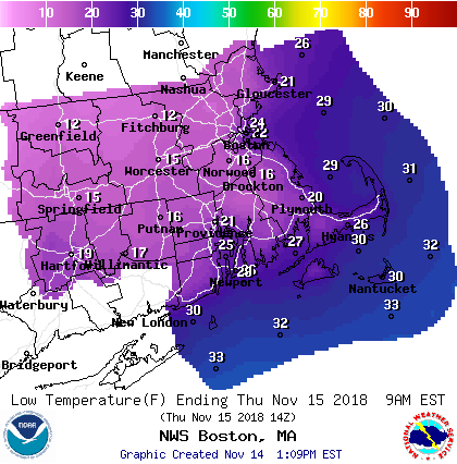
11/15/18 Morning Low Temperatures – NWS BOS
These low temperatures will allow for our next storm system, currently organizing over the southeast, to start as snow for most locations. Watch the loop below for how the storm coverage, particularly over Alabama, increases rapidly. A sign that a lot of moisture will be available as the system tracks northeast.

Southeast Regional Radar – 3 pm Wednesday – COD
TIMELINE
5 pm Thursday Evening: Snow will make its way into Southern New England from southwest to northeast during the evening hours Thursday. Southwest Connecticut gets in on the act first. The evening commute for the Boston metro area looks ok.

5 pm Thursday Evening – Tropical Tidbits
10 pm Thursday Night: Snow has overspread the region and is falling at a pretty good clip; upwards of an inch an hour. This system will really feature a front end thump as most of the snow falls during the first half of the storm system. Warmer air aloft and along the coast lines and southeast Massachusetts/Rhode Island will work its way in and eventually flip snow to rain.

10 pm Thursday Night – Tropical Tidbits
3 am Friday Morning: Very early Friday morning warm air should flip snow to rain for most locations inside of rte 495 and south of I-90. The hills of Worcester county and the Berkshires will fight to stay as snow or sleet for a while. Also around this time we will have to pay attention to an area of dry air moving in aloft. This should act to shut off the heavier precipitation as things will become more spotty in nature.

3 am Friday Morning – Tropical Tidbits
The next image highlights the potential for dry air (brown) to move in aloft and put a halt to the heaviest precipitation.

700 mb Relative Humidity – WeatherBell
9 am Friday Morning: Precipitation rates may pick up again for a time Friday morning as the storm center passes over the region. Some locations could flip back to snow for a period. IF things break right, there could be a 2-4 hour window of heavy precipitation during the late morning hours. Something to watch for.

9 am Friday Morning – Tropical Tidbits
1 pm Friday Afternoon: By early afternoon the storm system has moved off to the northeast and precipitation has quieted down across Southern New England.

1 pm Friday Afternoon – Tropical Tidbits
SNOWFALL

Snowfall
-Chris
Good evening all! What a pattern we are in, a string of storms tracking up the east coast and soaking New England. Starting with the tornado “outbreak” of October 23rd through the end of this week, at least 8 strong storm systems will have crossed the region. IF this pattern had developed during the winter months I would imagine that we would be challenging the snow blitz of 2015.
Storm #1 – Tuesday
First storm system for this week moves in overnight tonight and early tomorrow morning. The morning commute is a mess as heavy rain overspreads the region.
Rain organizing over the southeast will shift north and overspread the area after midnight.

Radar – 8 pm Monday 11/12 – COD
By 7 am Tuesday morning, a steady rain has taken hold of the region. Snow is falling in the higher elevations in Northern New England.

7 am Tuesday Morning – Tropical Tidbits
Rain moves out during the early afternoon. By 1 pm the rain is beginning to end for much of Southern New England.

1 pm Tuesday Afternoon – Tropical Tidbits
When all is said and done, a widespread inch to inch and a half of rain falls for most locations.

Total Rainfall – WeatherBell
Storm #2 – Thursday Night & Friday
Storm number 2 is much more interesting. It forms as a result of a strong atmospheric wave currently located over southwest Texas.

500 mb Vorticity – Tropical Tidbits
The surface low pressure center has origins along the Gulf Coast, so plenty of moisture will be available.

1 am Thursday – Tropical Tidbits
Throughout the day Thursday, a low pressure center will strength along the east coast and move northward. Precipitation moves into the area late Thursday evening and falls overnight and into Friday morning. There is the possibility that enough cold air will be around that the storm could start as snow.

Thursday Evening – Tropical Tidbits
Depending on how much cold air is available, the snow could linger through much of the overnight hours.

Overnight Thursday into Friday – Tropical Tidbits
And if things break the right way, snow could last into the morning hours for those locations away from the coast and with some elevation.

Friday Morning – Tropical Tidbits
The storm winds down around noon Friday. The above images should be taken with caution. The difference between rain and snow in Southern New England is only a degree or two. Small changes in the storm evolution will make big differences.
Follow up blog to follow when the forecast becomes more clear.
-Chris
