I swear that I have stopped asking for snow. I was all for last weeks system since it had the potential to bring 1 to 2 feet of snowfall. I personally received ~18″ and many saw 10-20″ (2′ in spots). That appeased my appetite for snowfall this year and I am ready to move on to Spring.
And yet it appears that Mother Nature has different plans. The forecast for Wednesday is for our 4th consecutive Nor’easter and this one comes with more snow. Fortunately this one does not look to be as significant as the previous two.
TIMELINE
Low pressure drifting northeast off the mid-atlantic coast will lift precipitation north into Southern New England Wednesday afternoon. Precipitation reaches the south coast around noon on Wednesday. By 2 pm, many south of the Massachusetts Turnpike are seeing snow.

2 pm Wednesday – Tropical Tidbits
By 8 pm Wednesday evening steady snowfall is falling across the region. Note how the snow struggles to expand into Central and Northern New England. A strong high pressure center to the north is blocking the precipitation from progressing further north.

8 pm Wednesday – Tropical Tidbits
Steady snow falls from early Wednesday evening through the early morning hours Thursday.

2 am Thursday – Tropical Tidbits
Snow wraps up from west to east near dawn Thursday morning. Clean up begins before the morning commute.

8 am Thursday – Tropical Tidbits
Now the big question becomes what to do with accumulations? If this were January, it would be easy: 10-12″ for everyone. But we’re now entering late March. Tomorrow marks the first day of Spring. The sun angle is strengthening. Are we able to accumulate during daylight hours? But wait, its been very below average for the last few days.
Just a sample of the many questions that have to be considered when forecasting snowfall accumulations for this system. The typical rule of thumb during the winter is 10:1 or 12:1. That is 10 or 12 inches of snow for 1 inch of liquid precipitation. Typically this time of year, that ratio is probably closer to 6:1 and produces a very heavy wet snow. Similar to the 2nd Nor’easter we had that caused all those power issues.
For my snow map I am going to use the a ratio of 9:1. Weighing all the factors of it being late March, below normal temperatures and strong sun angle. There’s no science behind it, just a gut feeling.
SNOWFALL

Snowfall
Well here we are on the eve of our third consecutive nor’easter. Unlike the previous two, this one looks like it will bring with it snow for everyone. Currently everyone in Southern New England is under a Winter Storm Warning and portions along the coast in Essex, Plymouth, Dukes and Barnstable Counties are under a Blizzard Warning; where the combination of heavy snowfall and strong winds will combine to produce Blizzard Conditions.
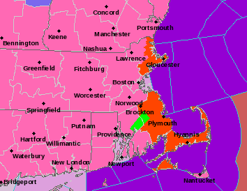
Watches, Warnings & Advisories – NWS Taunton
TIMELINE
Snow overspreads the region from south to north after midnight tonight and by 2 am light snow is falling for much of Connecticut, Rhode Island and southeast Massachusetts.

2 am Tuesday – Tropical Tidbits
By 8 am the remainder of Southern New England and much of Central New England are seeing snow. Snowfall across eastern Massachusetts and Rhode Island is quite intense. Snowfall rates are likely approaching 1-2 maybe even 3 inches per hour.

8 am Tuesday – Tropical Tidbits
Heavy snow falls throughout the day on Tuesday. The period of intense snowfall probably wraps up around 5 pm.

5 pm Tuesday – Tropical Tidbits
Lighter snowfall lasts through the evening before slowly tapering off as the midnight hour nears. The brunt of the storm shifts to Northern New England.

12 am Wednesday – Tropical Tidbits
By Wednesday morning the storm has pulled away and the digging can begin.

8 am Wednesday – Tropical Tidbits
WIND
Damaging winds from this storm will likely be confined to along the coastline and the Cape. That isn’t to say a strong gust isn’t possible inland, just that it isn’t as likely. Below is a graphic from the National Weather Service in Taunton, MA detailing the expected maximum wind gust.

Maximum Forecasted Wind Gust – NWS Boston
COASTAL FLOODING
Fortunately we are experiencing a period of low astronomical tides, so severe coastal flooding is not expected. Those areas that typically flood during a storm should expect to do so. Something like the storm two weeks ago is not expected.
POWER OUTAGES
Tomorrow’s storm will feature a lighter type of snowfall compared to our last storm which basically dumped 8-16″ of cement on us. With a more powdery snowfall expected, the potential for power outages is diminished. Those areas in southern Bristol & Plymouth counties along with the Cape could see some outages as the snow may be more dense in nature down there.
SNOWFALL
I still have some reservations about the snowfall forecast. In general the storm center is passing a little further to the east than is typical of our significant snow producers. But it is hard to ignore what the computer guidance is doing. The storm systems circulation is large enough that eastern areas at least will get in on the significant snowfall. Western regions should benefit from their increased elevation. The area between the Berkshires and 495 though is a question mark to me. That is where my highest amount of uncertainty lies.
Here is my final call with regards to snowfall. I have significantly increased totals to the north and west where previously I underestimated the impact increased elevation could have on the amount of snow that falls there.

Forecasted Snowfall
-Chris
Good evening everyone! As the final few who lost power during the last storm system have their power turned back on, it is time that we turn our attention to our next weather maker. This comes in the form of yet another nor’easter for Monday night and Tuesday. Even though I am writing this on Sunday evening, about ~30 hours from the onset of precipitation, there is still a great deal of uncertainty remaining in the forecast.
What we know for sure is that by tomorrow morning an area of low pressure will be forming off the South Carolina coastline. It will track northeast from there during the day Monday.

8 am Monday – Tropical Tidbits
Just how close the storm tracks to New England will eventually be determined by a piece of atmospheric energy diving southeast out of central Canada. On the water vapor satellite image below I have circled the two key features. The southern energy represented by the red circle located over southern Missouri will spawn the storm center off the Carolinas. The northern energy represented by the red circle north of Minnesota is playing catch up and will attempt to tug the storm system back closer to the coast. Just how much of a tug the northern stream delivers will determine just how close the storm comes. The stronger the tug, the closer the storm, the more snow everyone gets and vice versa. Right now I am favoring a small tug and a glancing blow from the storm. It would not take much for my forecasted snow totals to effectively double.

6 pm Sunday Water Vapor – College of DuPage
Timeline
Snow is likely to break out over the region Monday night into Tuesday, likely after midnight. Snow is heaviest Tuesday morning and into early afternoon. Snow tapers off late Tuesday afternoon. This snowfall will be lighter in nature. I am not expecting as severe as a power outage potential as the past storm where the snow was very heavy and wet in nature.
Note: I did not show you any images associated with the timeline because of the uncertainty associated with this system. IF the storm trends further east, the timeline shrinks. IF the storm trends further west, then the timeline expands slightly.
Snowfall
Overall the further east you are the more snow you should expect to see. Western New England may end up sitting this one out all together. Here is what I am currently expecting in terms of snowfall for very late Monday night and Tuesday. For the 12-18″ range I would lean towards the lower end of that range. It should probably be 12″+.

Potential Snowfall
Reminder it would not take much to significantly add or subtract from these totals. There is a lot of uncertainty still at play here.
-Chris
Two quick things out of the gate: 1) Boy did we take the brunt of last Friday’s storm on the chin! 2) Man did I mess up the snowfall forecast east of the Connecticut River…….turns out there wasn’t enough cold air around to flip us to snow. Live, learn and move on.
Speaking of moving on, our next storm is on tap for Wednesday afternoon – Thursday morning. This one is what you could call a more traditional New England snow storm with heavy snow over the interior, a rain/snow line along I-95 and more manageable wind gusts of 30-40 mph.
Our Wednesday storm system is currently causing blizzard conditions across the Dakotas and bringing heavy snowfall to Minnesota. Throughout Tuesday and the early parts of Wednesday it will drift east-southeast across the midwest towards the east coast. As it approaches the east coast early Wednesday morning an area of low pressure will begin forming near Cape Hatteras, North Carolina. This storm center will move north along the eastern seaboard towards Atlantic City, New Jersey. At this point, the storm center will receive a slight kick in the rear and be pushed east towards Nantucket before continuing its trip northward. The overall storm track should look something like this.

Likely Storm Track
TIMELINE
Heaviest of the snow falls from 5-6 pm Wednesday through 5-6 am Thursday morning. Don’t be surprised if there is some light snow in the air as early as Wednesday morning. Sometimes ahead of a snow storm (and particular ahead of our bigger ones) an easterly wind direction pushes enough moisture inland that light snows (little to no accumulation) break out ahead of the main show. That looks possible early Wednesday.

7 am Wednesday – Tropical Tidbits
More steady snowfall overtakes the region early Wednesday afternoon. Note the rain over the Cape and extreme southeast Massachusetts. The rain/snow line should march northwest during the afternoon.

1 pm Wednesday – Tropical Tidbits
By the time that the evening commute rolls around, most locations are seeing moderate to heavy snowfall. There’s going to be a 6-8 hour period where snowfall rates are on the order of 1-2″+ per hour. Rain/snow line has moved northwest to around I-95.

5 pm Wednesday – Tropical Tidbits
By 1 am Thursday the storm center is passing very near to Nantucket. Heavy snows continue inland. Precipitation may shut off across the Cape, SE Mass and Rhode Island for a time as dryer air works in aloft.

1 am Thursday – Tropical Tidbits
By Thursday morning the storm has rounded the Cape and is slowly making its way into the Gulf of Maine. The majority of precipitation has ended for Southern New England except for some light snowfall wrapping around the system.

7 am Thursday – Tropical Tidbits
Light snowfall may linger into early Thursday afternoon as the storm sits and spins in the Gulf of Maine; especially across southern NH and Maine.

1 pm Thursday – Tropical Tidbits
To summarize, snow breaks out Wednesday afternoon. The Wednesday evening commute is likely a mess. The Thursday morning commute is likely impacted as the cleanup begins.
WIND
Winds from this storm system will be nowhere near as strong as last Friday’s storm. Last Friday many locations gusted to hurricane strength and portions of the Cape gusted over 90 mph.

Max Wind Gusts – WxBell
WAVES/COASTAL FLOODING
Even though Friday’s storm is now thousands of miles away, the ocean off the northeast coast is still very angry. Large waves and higher than normal tides continue to pound the coast line. One has to wonder how much more it can take. Large waves and coastal flooding is expected from this storm. Coastal inundation shouldn’t reach the level it did on Friday, but those areas that typically flood during a winter storm should expect to do so.
SNOWFALL
Here is a good graphic from the NWS office in Taunton, MA outlining just how far inland the rain/snow line progresses. Now I personally think they might be a little too far west. I have drawn where I think it will ultimately park itself.

Precipitation Type Forecast – NWS Boston
First call snowfall map:

Total Storm Snowfall
-Chris
If you watched your favorite local news program last night, you probably saw the Meteorologist throw up his/her hands in uncertainty regarding the snowfall forecast for tomorrow’s nor’easter. And while we are less than 12 hrs from the start of the event, confidence is still very low when it comes to snow, however, there are still some aspects of the forecast that I am confident in.
Tomorrow a storm system is going to develop south of Long Island. It will become quite intense. It will be slow moving and will very likely perform a loop south of Nantucket. Strong easterly-northeasterly winds will allow for a lot of Atlantic moisture to fall over the region. Much of it falls as rain. Some of it will fall as heavy wet snow. The coastal flooding will likely be the most significant impact from this storm.
Timeline
Presently an area of low pressure is drifting eastward through the Ohio River Valley. By 7 pm tonight it will nearing the Ohio-Pennsylvania border. Heavy rain will be falling across much of PA with heavy snow on the northwest side along the shores of Lake Erie and western New York. 12-18″ of snow is expected east of Buffalo.

7 pm Thursday – TropicalTidbits
During the overnight hours, the primary area of low pressure will begin to lose its energy and a new secondary storm center will begin to develop east of Atlantic City, New Jersey. Batches of heavy rain will enter Southern New England from southwest to northeast between 8 pm and midnight. Most locations outside of the higher elevations in the Berkshires start as rain.

1 am Friday – TropicalTidbits
By Friday morning the new storm center south of Nantucket has taken over and heavy rain and strong gusty winds have over spread the region. The higher elevations in the Berkshires are fighting to hang on to snow, but ultimately may flip over to rain as well. Heavy snow is fall across much of New York where 12-18″ is expected west of Albany.

7 am Friday – Tropical Tidbits
Now comes the trickiest part of the forecast. As the storm center loops south of Nantucket and massive amounts of moisture are fire hosed in off the Atlantic, the atmosphere is working to cool itself off and transition from rain to snow. Elevation will play a key role in just how early locations change to snow. The Berkshires flip back to snow first, followed by the Worcester Hills and higher elevations in southwestern New Hampshire. Best estimate is that the flip to snow occurs sometime between 12-2 pm in these locations.

1 pm Friday – TropicalTidbits
During the late afternoon and evening hours the rest of Southern New England should flip over to snow. The lower elevations along the coast and in the river valleys will be last to do so. Snow will fall heavily for a period of time. The snow will be heavy/pasty in nature. Combined with strong wind gusts, power outages are possible.

7 pm Friday – TropicalTidbits
Eventually the storm center drifts far enough southeast and the fire hose of moisture off the Atlantic begins to die down. Precipitation will end from northwest to southeast overnight Friday into Saturday with the Cape and Islands hanging on the longest.

1 am Saturday – TropicalTidbits
By Saturday morning things have quieted down across Southern New England as the storm center drifts further out to sea towards Bermuda.

7 am Saturday – TropicalTidbits
Tides/Coastal Flooding

Coastal Flooding Concerns – NWS Boston
Of all the potential impacts from this system, the coast line is in the most danger. Back in January, the “Bomb Cyclone” brought with it a storm surge during high tide that broke the Blizzard of ’78 high water mark in Boston Harbor. That was for a single tide cycle for a relatively quick moving storm system.
Tomorrow’s storm is going to be quite strong with northeasterly winds that could be of hurricane force pushing water up against the coast line. Because the storm is so slow moving, it is expected that multiple high tide cycles will be impacted. In fact, due to the wind direction, the water from the first tide may not ever recede and a “low” tide may not be experienced.
Also different from the “Bomb Cylcone” is going to be the magnitude of surf just offshore pounding the coast.

Potential Wave Heights – NWS Boston
Oh……and its a full moon. Meaning the tides are already high; as evidenced by the inundation by today’s high tide in Scituate.

High Tide, Scituate, MA – Chris Gloninger NBC Boston
Wind
With any strong nor’easter there is the potential for power outages due to tropical storm to hurricane force wind gusts. Tomorrow’s storm will be no different.

Potential Max Wind Gusts – NWS Boston
Heavy Rain
Remember, most of this storms precipitation falls as rain.

Potential Rain Totals – NWS Boston
Heavy Snow
Before I get to my snowfall forecast, I want to talk about the potential this system has. The top analog for this event is the April 1, 1997 Blizzard. More commonly known as the April Fools Day Storm. A lot of similiarities exist here. Strong storm south of New England starting as rain with cold air attempting to work its way in and end as snow. During April 1, 1997, rain flipped to snow about 8-10 hours earlier than expected. The end result:

4/1/97 Total Snowfall
But what the heck is going to happen tomorrow? If anyone has any confidence, they are lying to you. Can I leave it as 0-24″ for everyone? Probably not. Therefore, the snowfall forecast map below is the best I can figure in terms of snowfall from this system. Note: The ranges are wider than normal. Thus highlighting the lack of confidence.

Storm Total Snowfall
-Chris
