Good afternoon everyone! We have a storm system moving in for Wednesday morning that will bring with it some snow for many places. Places inside of say route 128/495 will have to deal with some warmer air and mixed precipitation. But where it stays all snow, a plowable event is likely.
Currently the NWS has those counties in northern CT, RI and outside of SE MA under a Winter Storm Watch. Meaning that the potential for greater than 6″ of snow exists.
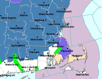
NWS Taunton Weather Advisories
The timeframe for this system is from approximately 2 am Wednesday morning to around noon. Snow will overspread the region from southwest to northeast before dawn Wednesday. The morning commute will be significantly impacted for those areas where snow is falling. Those would be the areas in the blue shading in above image. The evening commute shouldn’t be impacted except for cleanup activities taking place.
When all is said an done it’s a plowable event for the northwest zones.

Total Snowfall
Will advise with update if necessary.
-Chris
