Good morning all. Last night’s computer guidance has continued the slight westward trend with Thursday’s storm. Which only adds confidence to the forecast from last night.
Here are the facts:
- A significant winter storm is imminent for tomorrow across New England;
- Snow breaks out from south to north between 4 and 7 am;
- Heaviest snow falls between 9 am and 5 pm;
- Winds will gust over 50 mph for many (especially near the coast);
- Blizzard conditions will be widespread across eastern Southern New England; and
- Upwards of 12″ of snow or more for many locations.
Current Satellite
The two pieces of atmospheric energy that I highlighted yesterday are rapidly approaching the Gulf coast. In response an area of low pressure has formed off the east coast of Florida. It will begin its trek up the east coast today. Undergoing everyone’s new favorite buzz word bombogenesis. Bombogenesis is a highly technical meteorological term for a storm system strengthening by 24 mb or more in less than 24 hours. It is in essence a meteorological “bomb”. In reality, tomorrow’s storm has the potential to intensify by nearly 48 mb in 24 hours.

9 am Water Vapor Image – COD
As a quick aside, it is actively snowing in northern Florida.

Florida Snow
Watches and Warnings
Ahead of tomorrow’s storm the National Weather Service in Taunton has issued Winter Storm Warnings (pink) and Blizzard Warnings (orange) for much of the region. The blue shade across New Hampshire is for a Winter Storm Watch. This should be upgraded to a Winter Storm Warning soon. Not seen in this image is a dark green color for the coast lines. A Coastal Flood Warning has been issued for tomorrow as well. Strong onshore winds coupled with the day time high tide could lead to potential significant coastal flooding; especially in low lying, east facing areas.
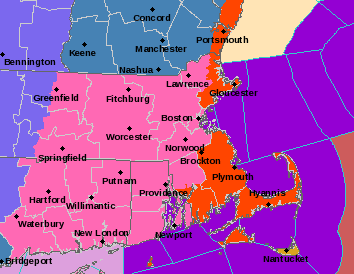
Watches and Warnings – National Weather Service
Timeline
Snow overspreads the region south to north during the early morning hours between 4 and 7 am.

5 am Thursday – Tropical Tidbits
By 10 am heavy wind swept snow has taken hold across the area. Blizzard conditions will be occurring along the coast and at times over the eastern half of southern New England.

10 am Thursday – Tropical Tidbits
The heaviest of the snow fall from approximately 9 am to 5 pm tomorrow. After 5 pm things begin to wind down from southwest to northeast as the storm center approaches out latitude.

5 pm Thursday – Tropical Tidbits
By midnight the storm center has passed our latitude and is unleashing it’s fury on eastern Maine and Atlantic Canada. Outside of the occasional snow shower or flurry, the snow will be over and the digging can begin.

Midnight Friday – Tropical Tidbits
Wind
The forecast from yesterday remains unchanged in that a highly anomalous; i.e. abnormally strong, storm system, with a central pressure equal to that of a category three hurricane is the forecast for tomorrow. With such a strong system, the potential for damaging wind gusts and power outages is high. Especially for southeastern Massachusetts, areas near/along any coastline and the Cape and Islands.

Potential Wind Gusts – WeatherBELL
Should power outages occur then the real trouble begins. Temperatures following the storm are forecasted to drop back into the single digits to below zero for Friday – Sunday for much of the region. It is going to get very cold, very fast should power be lost and heating fail.
Snowfall
When all is said and done many should be digging out from greater than 8″ of snowfall. The limiting factor with this system is time. It only snows for about 12 hours in most spots. To hit the higher totals we are really going to have to ring as much moisture out of the atmosphere as we can in a short time. Some places should be able to do just that. As I said yesterday, I have this feeling that there is going to be a pocket where someone picks up 18-20″, but with such a dynamic storm as this one, pinpointing that location is nearly impossible. My leading candidates are the route 24 area or northern Worcester county. But only time will tell.
Ultimately I have decided not to make any changes to my snow map from yesterday.

Total Snow
-Chris
