Good morning everyone! As mentioned yesterday, today holds the potential for some rather strong thunderstorms. So I wanted to give you an update of what we know very early this morning.
Northeast Radar as of 7:30 am
Two key elements are leftover from yesterdays storms which in the end produced 14 tornado reports across Michigan and Illinois. The large batch of showers and storms across Northern New England will likely be the downfall of any severe weather up there. It will bring much needed rain, but severe chances will be limited do to lack of solar heating.
Southern New England is where the forecast becomes tricky. The whole key to our severe chances today lie with the second batch of thunderstorms across Northern Pennsylvania and southern New York. This system is marching east and if it maintains itself into SNE (sometime around 1230-1 pm) then it will severely limit our thunderstorm potential for the day.
IF the thunderstorm complex survives the trip, then it will rob the atmosphere of most of its instability and due to the timing of a little after noon; the atmosphere will not have sufficient time to recover and our severe chances will be squashed.
IF the thunderstorm complex doesn’t survive the trip or makes a hard right turn to the south and Southern New England is allowed to bake in sunshine for a few hours, then the chances of severe thunderstorms is greatly increased.
As for a timeframe today, keep an eye to the sky starting about noon. It could be that all we get is the leftover thunderstorms from PA/NY around noon. Or we could get something bigger a bit later. Time will tell.
-Chris
Howdy everyone! Long time no talk!! Unfortunately with the riggers of everyday life and work it is difficult to stay interested in updating this unless something good is in the works.
Which means that since I am updating this, something good must be in the works. That comes tomorrow in the form of thunderstorms.
After a relatively slow start to our Spring and Summer with cool temperatures and rather boring weather; things certainly have the opportunity to be interesting tomorrow.
Monday 6/22/15 Tornado Outlook from SPC
The image above is from the Storm Prediction Center and is there tornado probability forecast for today. Places from Des Moines, Iowa to Detroit, Michigan have a chance of there being a tornado. Now, a good rule of thumb for New England severe weather events is to take a look at what occurs over the Great Lakes states the day before. So weather weanies across New England will be very interested in what unfolds today across the Great Lakes.
As for us tomorrow, the image below represents the forecast depiction of the pieces to the puzzle. We need to pay attention to the strengthening low pressure center (red L) in southern Canada, the warm front (red line w/red half circles) pushing northeast through New England, the pre-frontal trough (dashed tan line) moving east through New York, and the trailing cold front (blue line w/blue triangles) marching east near Buffalo.
12z Tuesday 6/23/15 Surface Depiction – WPC
As the warm front lifts through the region early tomorrow morning a shower or downpour is possible. Behind the warm front warm, humid air will flow in from the south. This air mass should be very unstable and be primed for thunderstorm activity. Thunderstorms will likely fire in eastern New York or western SNE and push east towards to coast during the afternoon.
These storms could pack quite a punch as many of the numerous ingredients needed for strong to severe thunderstorms will be in place. A moist, unstable air mass should move in during the morning. Strong upper level winds (shear) will be in place to help support thunderstorm activity. A strong lifting mechanism in the form of a cold front will be moving through the region during the late afternoon. With so many ingredients together in one place (and especially if we can get winds to be more backed in the boundary layer) a tornado or two can not be ruled out.
One thing that we will have to be careful of is any left over morning showers and storms that survived the night and pushed this far east. Often times our severe weather events are squashed by morning convection that was left over from the day before.
The simplest way to tell if the event needs to paused or muted or cancelled is whether or not the sun comes out before late morning. If the sun comes out before noon tomorrow, then the atmosphere should be primed for thunderstorm activity.
I’ll leave you for now with one high resolution models depiction of what the radar could look like tomorrow at 5 pm. It has a line of strong storms from Portland, Maine to Philadelphia. I should have an update either late tonight or tomorrow morning recapping what we learned from today across the Great Lakes and what we can expect tomorrow afternoon.
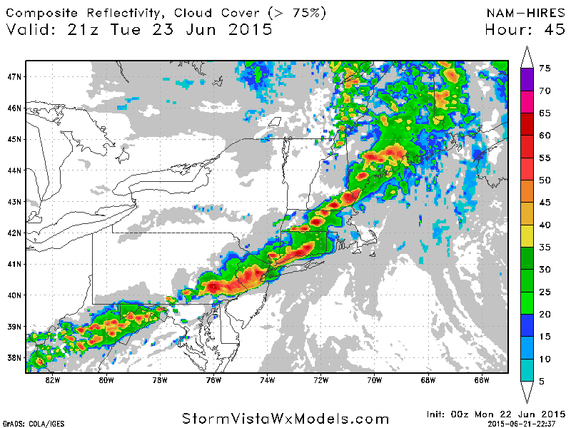
00z 6/22/15 Hi-Res NAM for 5 pm Tuesday
-Chris
