My favorite movie all-time is Twister with Helen Hunt and Bill Paxton. At one point in the movie while at a maintenance garage/hotel for night a tornado is bearing down on them. One of the members of the chase team realizes this and begins yelling: “It’s coming! It’s headed right for us!!”
Well that is how I feel presently. A Blizzard of potentially historic proportions is going to form and take shape off the Mid-Atlantic coastline and slowly drift northeastward bringing with it historic snowfall amounts and widespread potentially damaging wind gusts.
As one would expect, with such a storm bearing down on us the National Weather Service is right on top of things and currently has warnings raised for the entire region ahead of the storm.
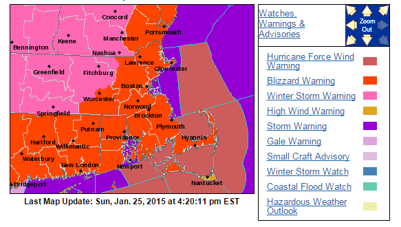
Current warnings via NWS Taunton
That orange shading is a Blizzard Warning and it basically covers the entire region. Honestly, all of Southern New England will experience Blizzard conditions at times, but for a Blizzard Warning to verify Blizzard conditions must be observed for three consecutive hours. And while Blizzard conditions are likely everywhere I’m not sure the time requirement will verify; hence the entire region not being covered in orange.
That being said those regions under the pink are under Winter Storm Warnings for excessive amounts of snow falling from this storm. To put numbers on a map, here is the National Weather Service in Taunton’s forecasted snowfall amounts from this system:
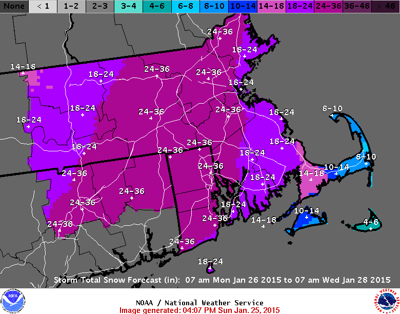
NWS Taunton Snowfall Forecast
No your eyes do not deceive you! That dark purple shading is for 24-36″ of snowfall. Meanwhile the lighter shade of purple is nothing to scoff at as that represents 18-24″ of snow. Lesser amounts on the Cape and Islands due to lower snowfall rates and possible mixing.
But how exactly are numbers that historic going to occur? Let me show you.
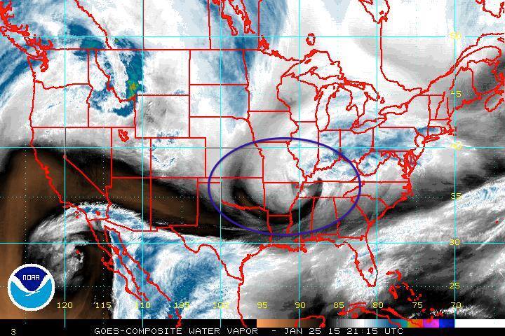
Water Vapor Image
In the image above I have circled our storm system with the purple oval. This storm is making a bee-line from the Canadian Prairies to the East Coast. Over the next 2 to 3 days the storm should evolve as such:
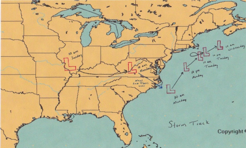
Forecasted Storm Track
Leaving its current location the storm will swing through the lower Ohio Valley. Eventually during the day on Monday a new storm will begin to form off the North Carolina coastline. This storm will track northeast with time; eventually slowing down as it nears Nantucket. I have tried to illustrate it above that during the day on Tuesday it is possible (likely) that the storm center will perform a counterclockwise loop south of Nantucket & Martha’s Vineyard. This is a classic signature in our historic Blizzards including 1978 & 2013.
Finally late Tuesday afternoon and overnight into Wednesday the storm will slowly begin drifting east-northeast, but not before unloading all of its moisture and energy on the Mid-Atlantic & New England. For a broader view of possible snow totals see below:
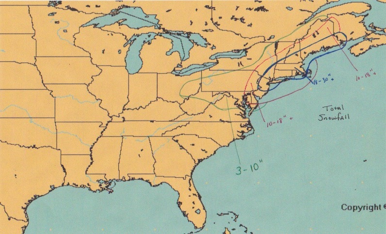
Possible Snowfall Totals
As you can see basically the entire I-95 corridor and adjacent regions from Philadelphia to Bangor are looking at 10″+ of snow. With New York City, Hartford, Providence, Worcester, Boston & Portland bearing the brunt of the storm and possibly seeing snowfall amounts of up to and over 2 feet.
TIMING:
As luck would have it this one aspect of the storm that the models currently differ on. Some models have snow moving in before the evening commute home; while others wait until later in the evening. Either way snow will overspread the area of south to north during the evening Monday. My best guess is that snow overspreads the area anytime after 7 pm. Meaning that the evening commute home should be ok.
By midnight all of Southern New England is in the storms clutches with snowfall rates over 1″ per hour and up to 2-3″ per hour in some spots at times.
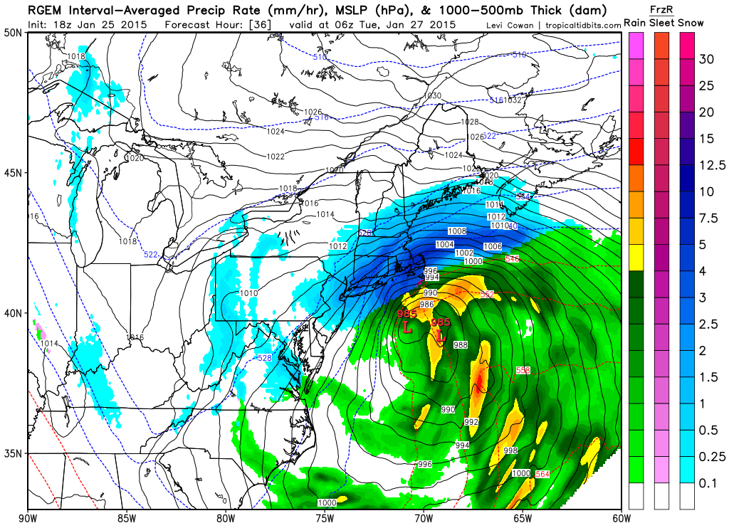
RGEM 1 am
The heaviest of the snow will fall from midnight Tuesday through early Tuesday afternoon. Essentially a 12 hour thumping where 1-2 feet of snow fall.
By 1 pm Tuesday the storm will be running on fumes. Just like any kind of engine a storm only last as long as there is fuel. By early Tuesday afternoon the storm will be in its dying stages. Snow will becoming more light & scattered in nature, but could still be heavy at times. As you can see from the image below the shades of blue have become lighter and the precipitation shield is begining to become more ragged.
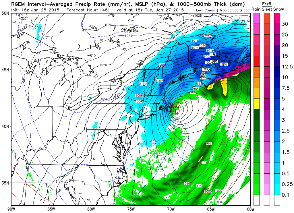
RGEM 1 pm Tuesday
That isn’t to say that the storm will be completely done at this point. It will still be lingering just east of the Cape and winds will still be gusting to near 50 mph at times.
Finally very early on Wednesday morning the storm will have pulled far enough away that we will finally be able to bid ado to our storm system.
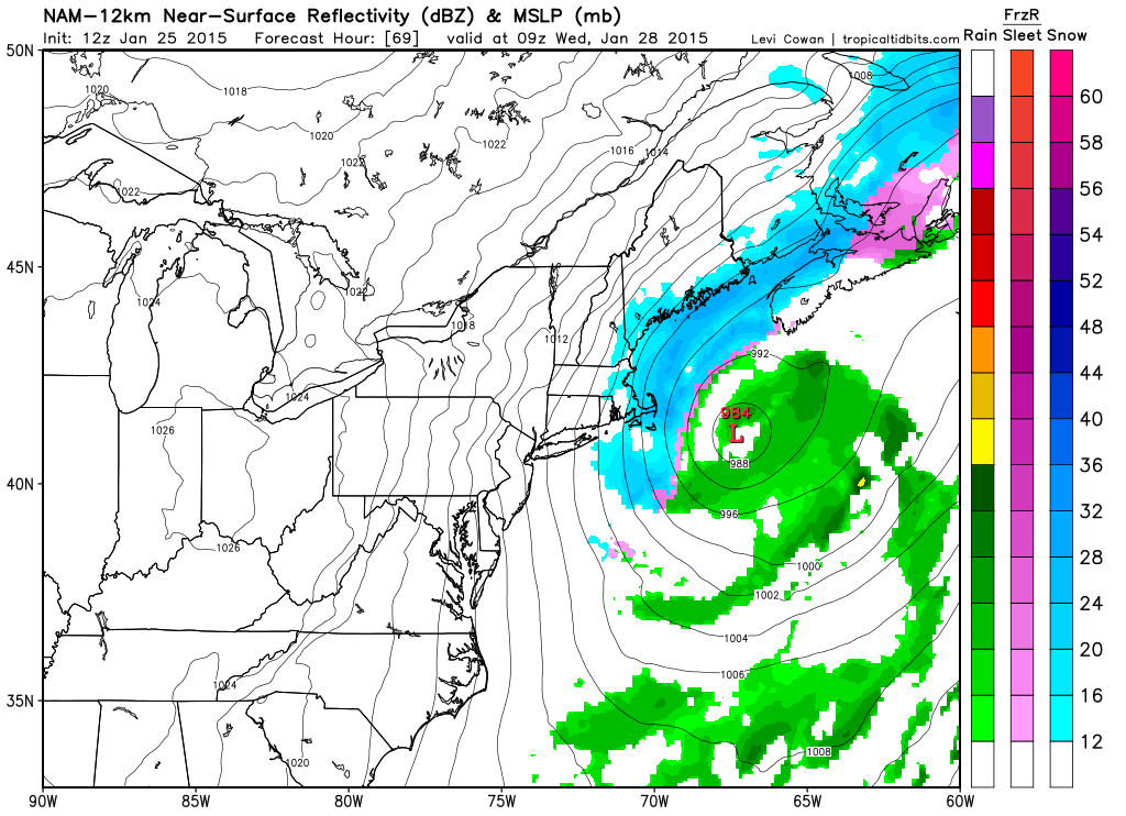
NAM forecast 4 am Wednesday
Recap: Snow overspreads the region Monday evening after rush hour. Snowfall rates greater than 1″ an hour or greater can be expected from Midnight Tuesday through the early afternoon. Light snow and gusty winds from Tuesday afternoon through very early Wednesday morning.
WINDS:
Unlike our last storm on Saturday this one will feature and area of high pressure just north of the border in Canada. The co-location of a strong high pressure with a rapidly intensifying low pressure center should allow for the winds in this storm system to become quite impressive.
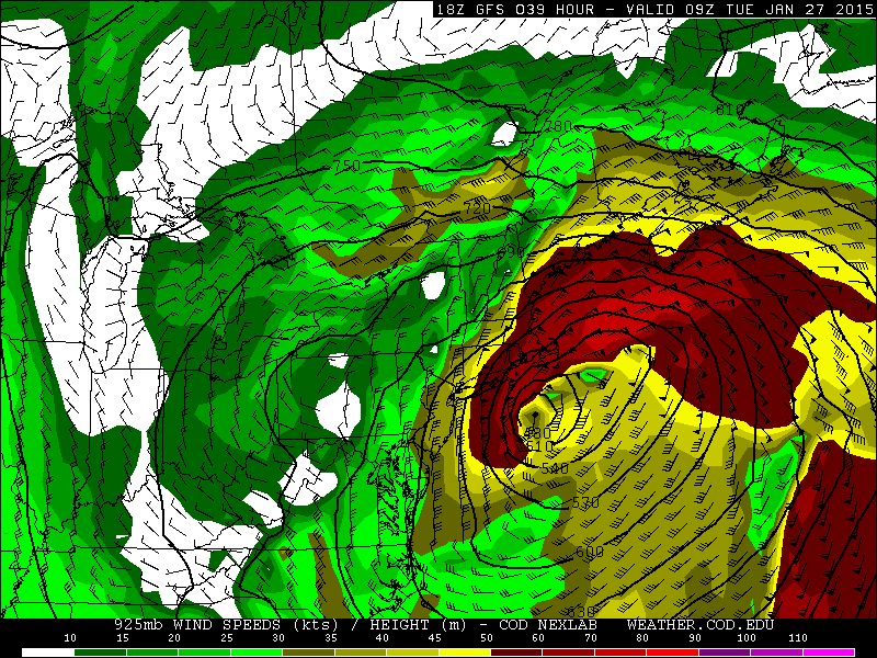
GFS 925 mb Winds 4 am Tuesday
The above image represents the 925 mb for 4 am Tuesday morning with wind speeds at 2000 ft above the ground nearing or greater than 50 knots (58 mph) for all of eastern SNE. These winds will be able to mix down to the surface frequently throughout the hours of heaviest snowfall. Wind gusts for much of SNE could be as strong as 50 mph. Nearer the coast wind gusts on the order of 60-70 mph are possible. And along the shoreline winds nearing hurricane strength are possible.
The period of strongest winds could be quite long due to the storms very slow movement. For example the following image shows nearly the same wind set-up as above, just 15 hours later with the region of highest winds slowly pulling away.
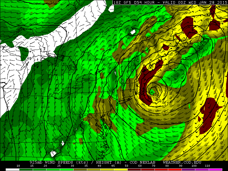
GFS 925 mb Winds 7 pm Wednesday
TIDES:
Luckily the astronomical high tides have past for this month, but with such a slow moving system and continuous northeast winds water should begin to pile up along the coastline. Coastal flooding can not be ruled out with this system. Especially in those locations that always seem to flood (Revere, Nahant, Scituate).
SNOWFALL:
And finally what everyone is looking for the snow map. If you have been reading this far I won’t bore you anymore.
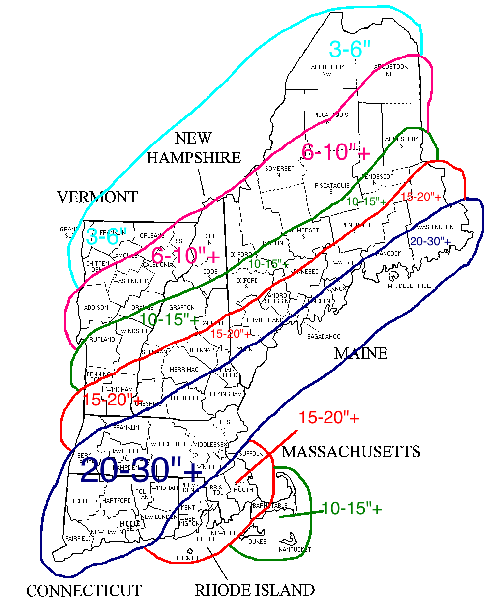
Expected Snowfall
I’m expecting a wide spread swath of 20-30″ of snow for much of Southern New England and coastal Maine. As you approach the Cape and Islands the forecast totals go down due to lower snowfall ratios and possible mixing at times.
North and west of the jackpot zone amounts will lessen the further north you get simply due to the lowering amounts of precipitation.
All in all this could be one for the record books. Snowfall rates such as this are reserved for the top all-time snowstorms in Southern New England history. If all goes according to plan; 1888, 1978, 2005, 2013 will all have company among the greatest snowstorms in region history.
-Chris

wildcard
Good job Chris, very thorough. Wish I could be there for this one.