Earlier this week I posted a blog in which I highlighted two potential storm chances; the first being Saturday (today) and the second to follow on Tuesday. As the models tried to hone in on a solution for today’s event they began to struggle with figuring out the forecast for Tuesday. Which is easy to understand when one considers that the outcome of Tuesday’s event would be greatly effected by the outcome of Saturday’s event.
Well last night with the outcome of today’s storm all but decided the New England weather community was treated to an outstanding model run from the European computer model. Seeing last night’s European model advertise a long duration major nor’easter was quite entertaining and was met with a “Hey that’s kind of nice” attitude.
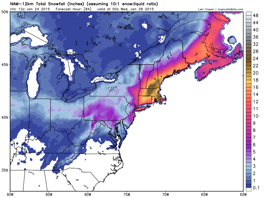
Until this morning when the first model of the morning came in with a nearly identical solution to the overnight European run. Below is the model forecasted total snowfall from the 7 am run of the NAM computer model courtesy of Tropical Tidbits. All images courtesy of Tropical Tidbits.
Snowfall Forecast through 7 pm Tuesday
Based on the image above everyone who lives under or inside of the yellow shading would see 16-18″ of snow or more. The darker shades are the regions that based on this model that would receive upwards of 20-22″ of snow.
The fun for this morning was just getting started following the NAM. Below is the morning run of the GFS. Which had the storm passing a bit further east of the area. Leading to the higher totals along the coast versus being more widespread.
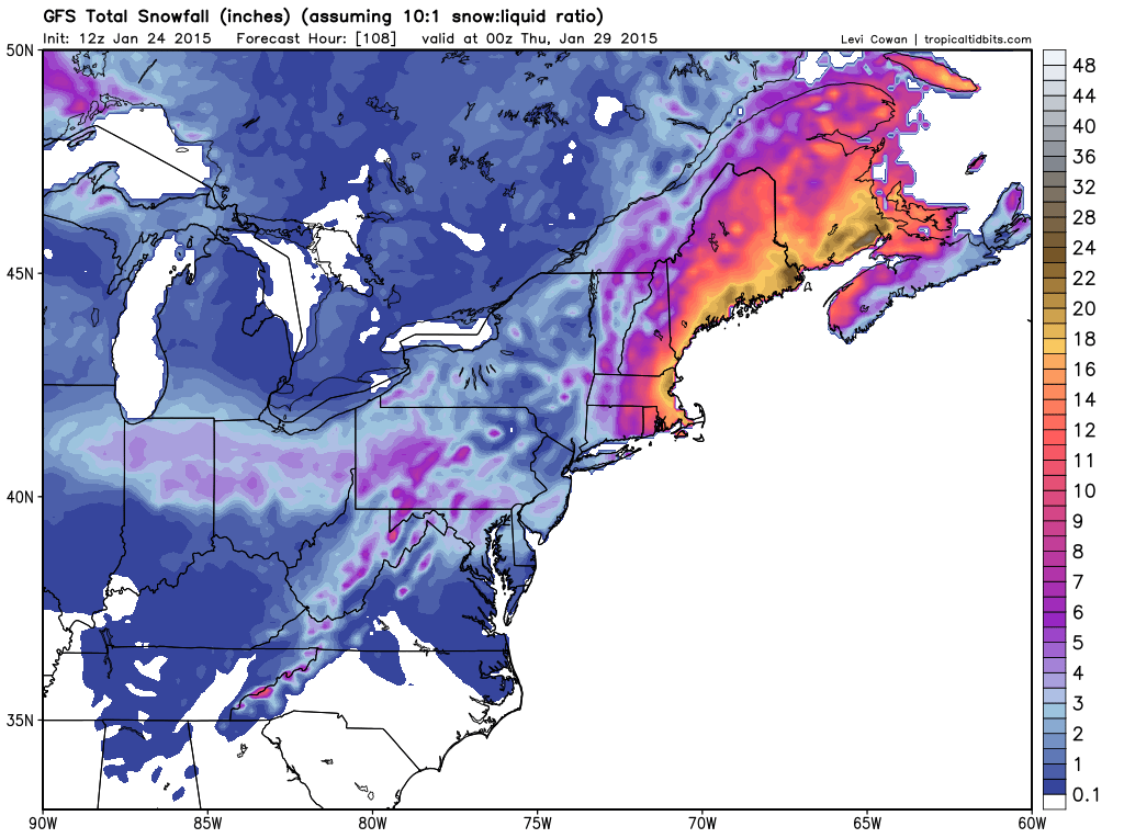
12z GFS Snowfall
But this model in particular has been trending back to the west for atleast two days of model runs. This trend back west only continued with its afternoon run. See the snow map below which gives all of New England nearly a foot or more.
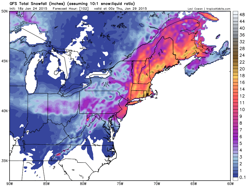
18z GFS Snowfall
Want more? How about the Canadian? It too puts out very similar snowfall amounts for the region.
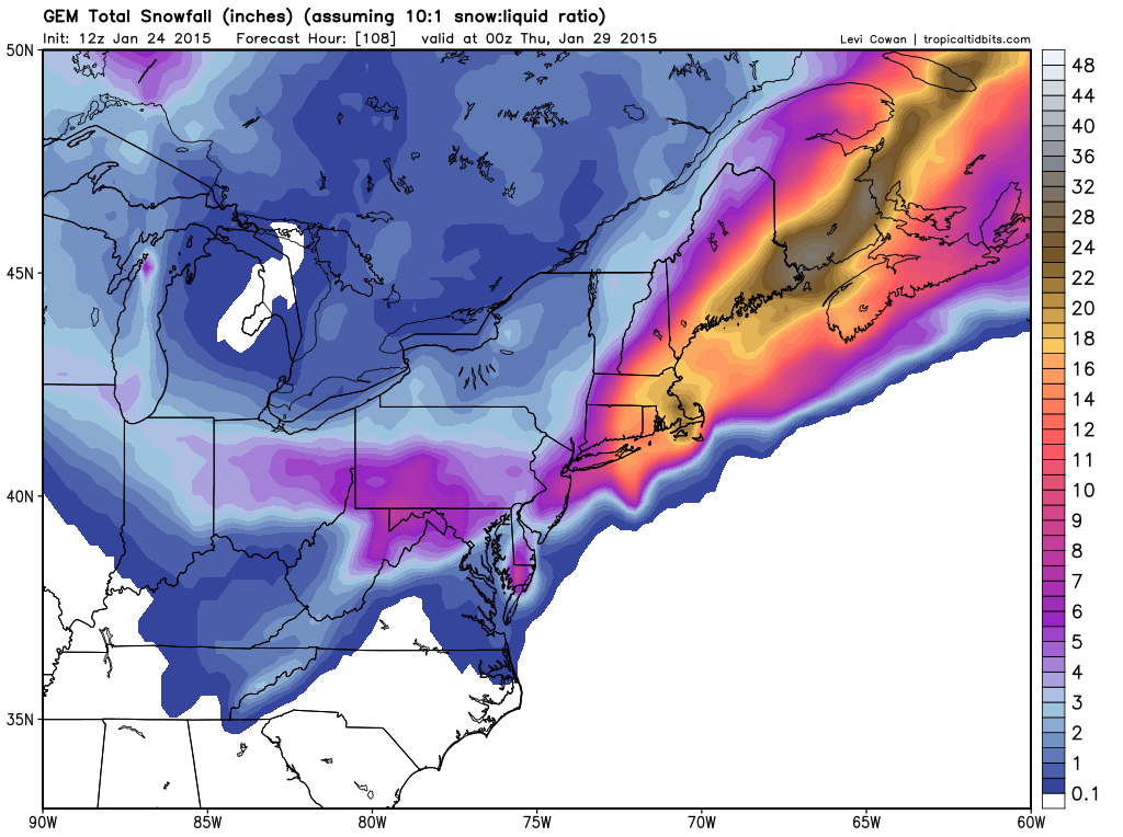
12z CMC Snowfall
Alright do I have you attention yet? Let’s get a little more detailed.
Storm Evolution:
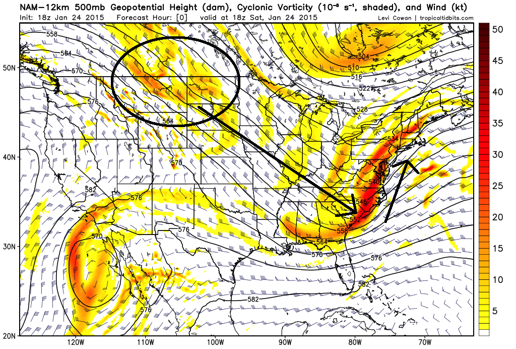
18z NAM 500 mb Vorticity Initialization
Nor’easters and storms don’t form randomly. To create a storm you need energy to drive the system. In the image above the yellow and red shaded regions represent vorticity at the 500 mb level of the atmosphere. When we think of vorticity, we can think of energy. And for our Tuesday event the energy that forms our storm is that region of energy I have circled over Montana, North Dakota and southern parts of Manitoba and Saskatchewan. This energy is going to beline for the southeast coast before turning north up the East Coast.
Once this energy reaches the coast a storm center will begin to form off the Carolinas. The image below represents the storm taking shape before moving north.
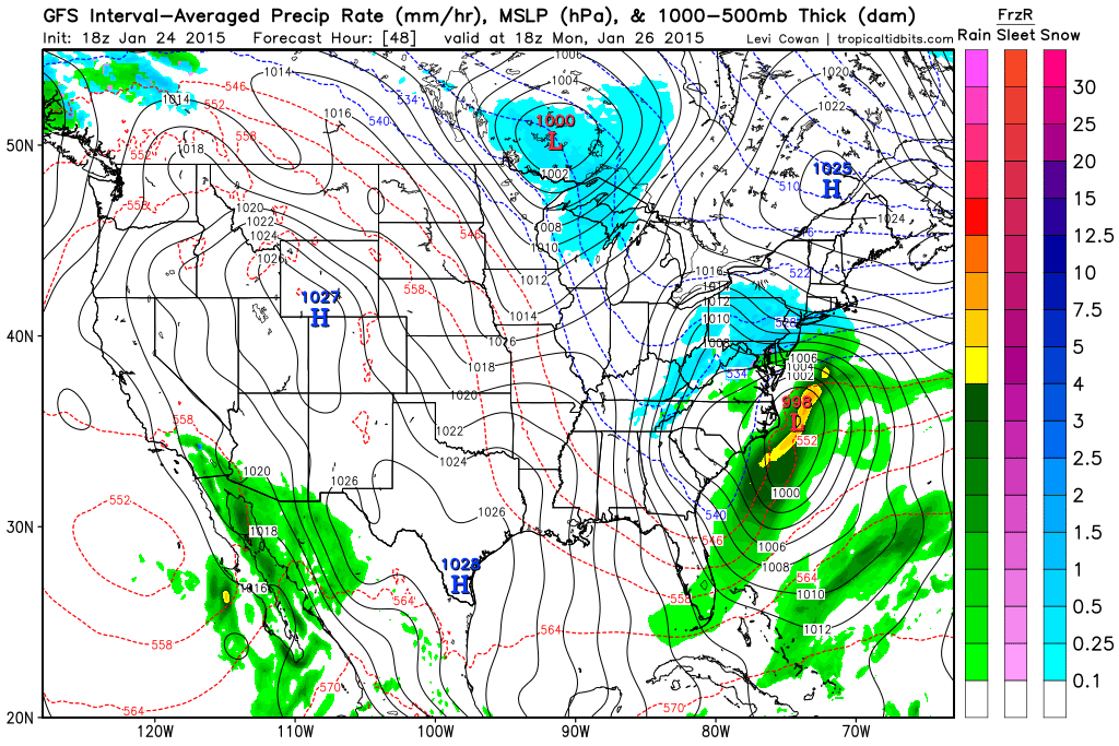
18z GFS Forecast for 1 pm Monday
From the Carolina coast the storm will slowly move north before passing slowly southeast of Southern New England.
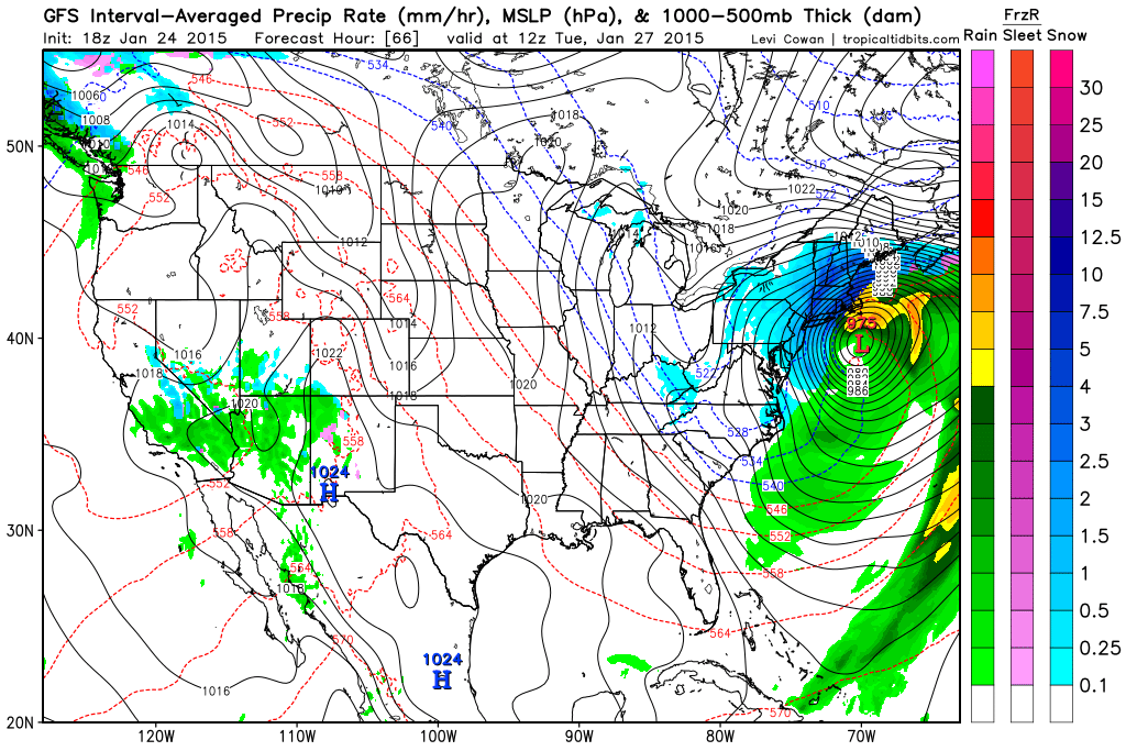
18z GFS Forecast for 7 am Tuesday
One thing that is becoming evident about this system is going to be its slow movement. At about the same time that the storm is going nuts south of Southern New England, the upper level energy will be attempting to capture the surface reflection. When that occurs the storms forward motion really slows down and often times the storm center will almost perform a loop south of us. Many of our biggest storms have performed this loop including the Blizzard of 1978 and the February Blizzard of 2013 (Nemo).
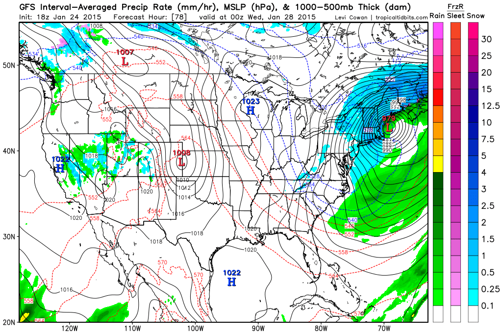
18z GFS Forecast for 7 pm Tuesday
It isn’t until 7 am Wednesday morning that the storm center and snow finally pulls away from Southern New England based on this model run.
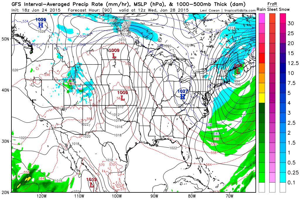
18z GFS Forecast 7 am Wednesday
Wind:
Can’t have blizzard conditions without wind can you? The image below is the NAM representation of the 850 mb winds during the height of the storm. The image shows winds that are a couple thousand feet off the ground of 60 to 80 knots. Due to the intense nature of this system wind gusts on the order of 50 mph should be able to reach down to the surface. At the same time winds nearing hurricane strength will likely be battering the coast lines.
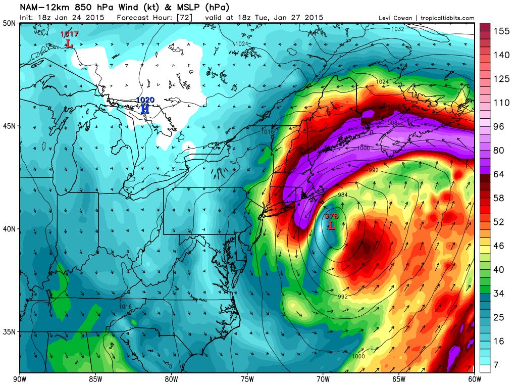
18z NAM 850 mb Wind for 1 pm Tuesday
Timeframe:
Along with snowfall the start and end of the storm is in flux right now. If I had to put a time one it I would expect snow to start overspreading the region around midnight Monday into Tuesday and last through the day Tuesday. Eventually winding down sometime around midnight Tuesday into Wednesday.
Snow Amounts:
Based on the images at the beginning of the blog it looks like most locations should be able to expect at least a foot of snow. I feel this is a good baseline to start with and we can adjust totals from there (likely up).
Recap:
Major winter storm coming for Tuesday. Blizzard conditions are likely at times across much of SNE and Maine. Right now a foot or more of snow is looking likely for all.
Next blog post will likely be late tomorrow afternoon and evening. I will likely have a snow map out with that one.
-Chris
