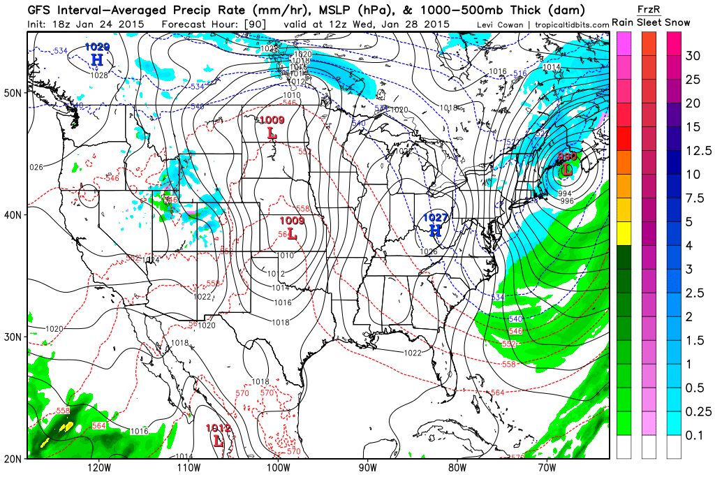
Another winter storm is on the way for Monday and this looks to be a significant one. Right now it looks like much of the region can expect 8-12″ of snow.
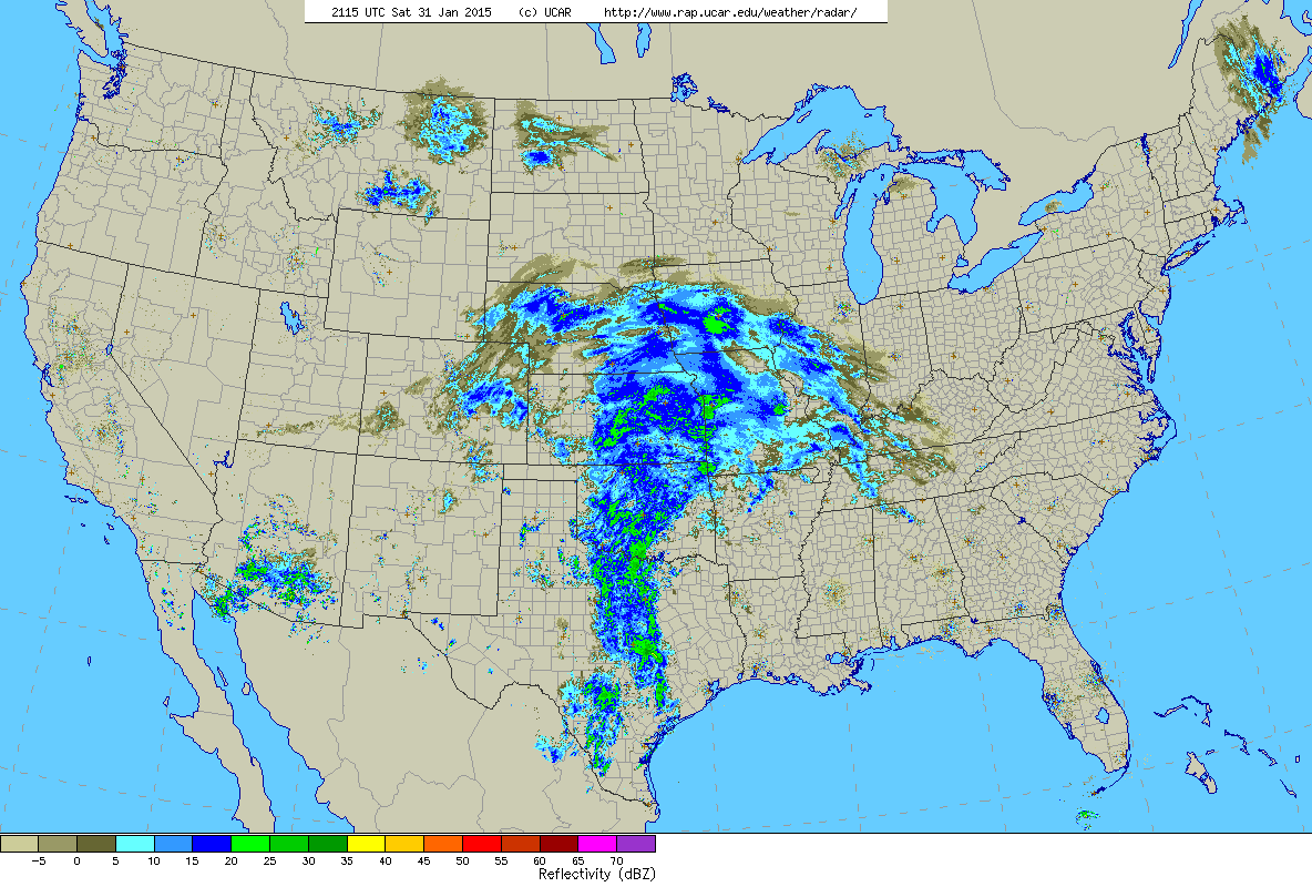
4 pm Saturday Radar
The image above is the current U.S. radar as of 4 pm Saturday afternoon. Our storm is gaining steam over the Plains states and is steadily moving east. Along it’s path it will dump upwards of a foot of snow from Iowa to Maine.
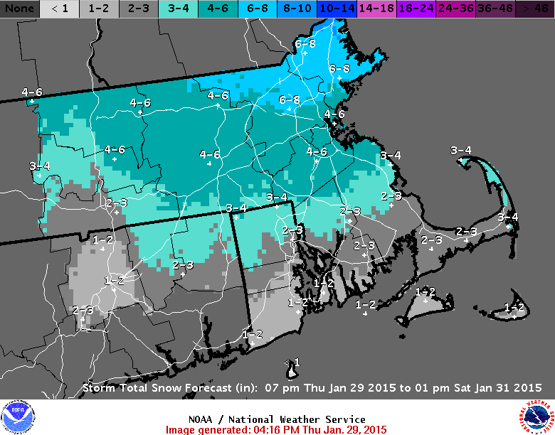
Snow will begin to overtake the region early Monday morning from west to east between 1-3 am. Snow will be heavy at times during the day on Monday before tapering off late Monday evening. When all is said in done a general 8-12″ should blanket Southern New England with slowly decreasing amounts to the north and along the South Coast.
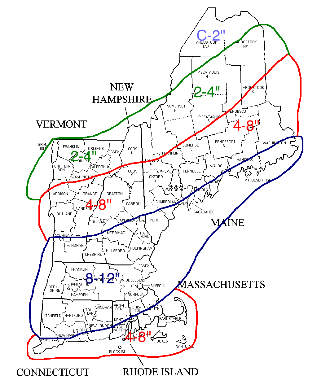
Snowfall through Monday Evening
Amounts are lower along the south coast due to potential mixing with sleet or rain at some point. It’s this potential mixing and just how far the mixing line makes it north that is keeping this map rather broad. If confidence increases overnight a more detailed map will be made.
-Chris
Boy that was a good one huh? 15-30″ for everyone east of Worcester County. That was awesome and something we likely won’t do again for quite awhile.
But while our memories of the Blizzard of 2015 are still fresh in our mind; how about we throw a little more snow on top of the snow pack.
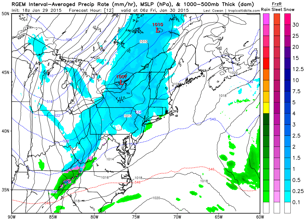
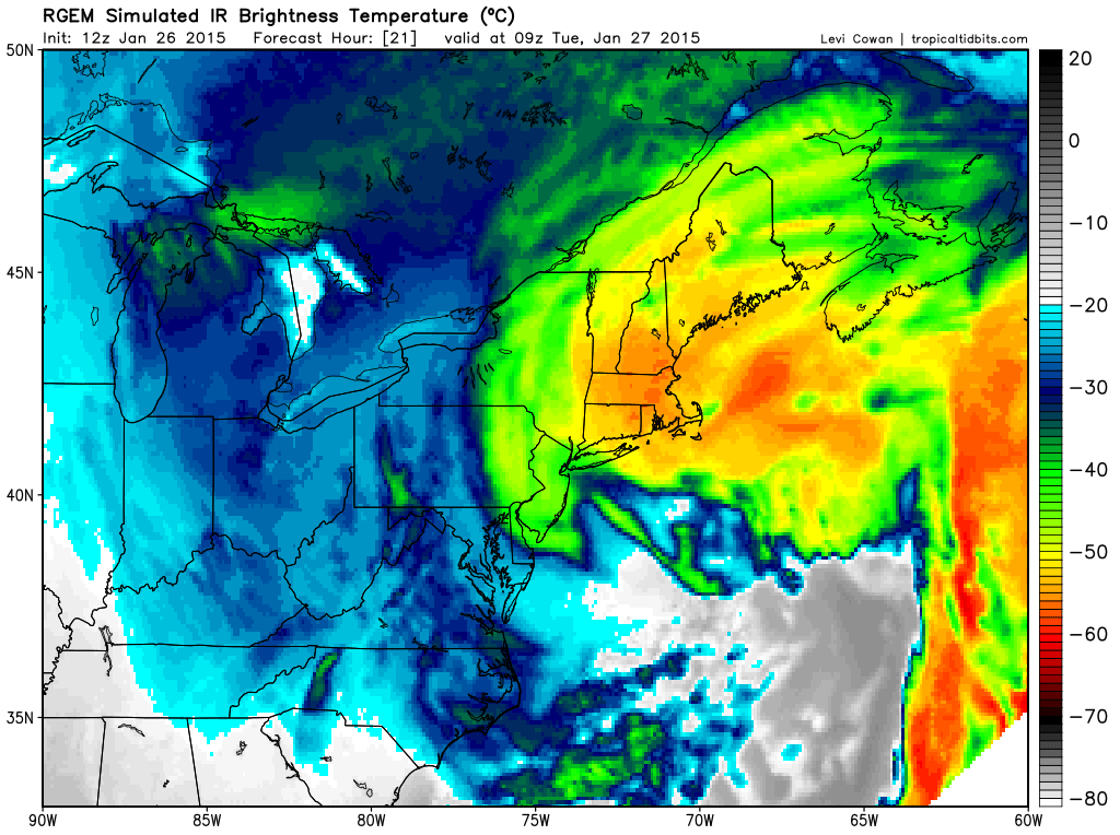
That’s right another system is headed our way for tomorrow morning and will linger through until Saturday morning. But thankfully this time it won’t be that big of a deal for most places not in the state of Maine.
Sometime around midnight tonight light snow will overspread much of the area as shown below with the 06z image from the RGEM model courtesy of Tropical Tidbits.
1 am Friday Morning RGEM
Light snow should last through much of the morning and will eventually become much more spotty in nature by the afternoon.

7 pm Friday RGEM
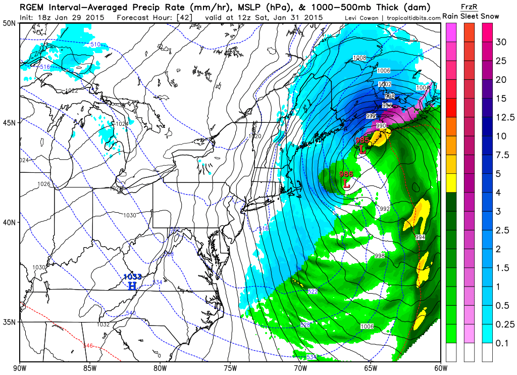
By tomorrow evening the snow should have all but tapered off across Southern New England. The state of Maine and northern New Hampshire however will continue to receive light snow. Snow will be heavier at times along the Maine coast and central Maine. Represented by those darker shades of blue in the image above.
Eventually however one last round of light snow should spin back into eastern Massachusetts for early Saturday morning.
7 am Saturday RGEM
The storm will pull away during the morning hours on Saturday. When all is said and done much of the region will have picked up a few inches. Slightly higher amounts along the north shore, merrimack valley, southeast New Hampshire and Maine are expected.
Due to time constraits I’m cheating a little bit with the snow totals forecast and defaulting to the National Weather Service. In order are the snow accumulation forecast from the Taunton, Gray, and Caribou offices.
NWS BOX Snow Forecast Map

NWS GYX Snow Forecast Map
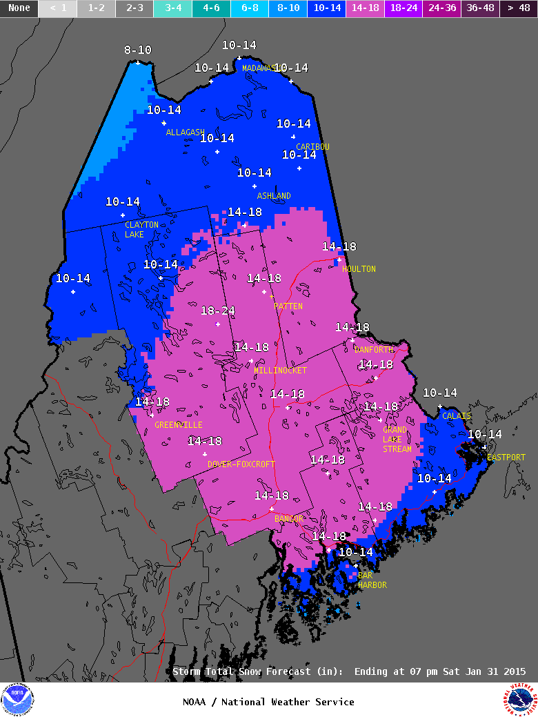
NWS CAR Snow Forecast Map
Still keeping an eye on a potential storm for Monday. Right now it looks to only brush us as it passes south of the region, but it is close and will need to be monitored.
-Chris
Everything is a go for the Blizzard of 2015. Currently the storm is taking shape off the North Carolina coast and will begin the process of bombing out and slowly drifting northward.
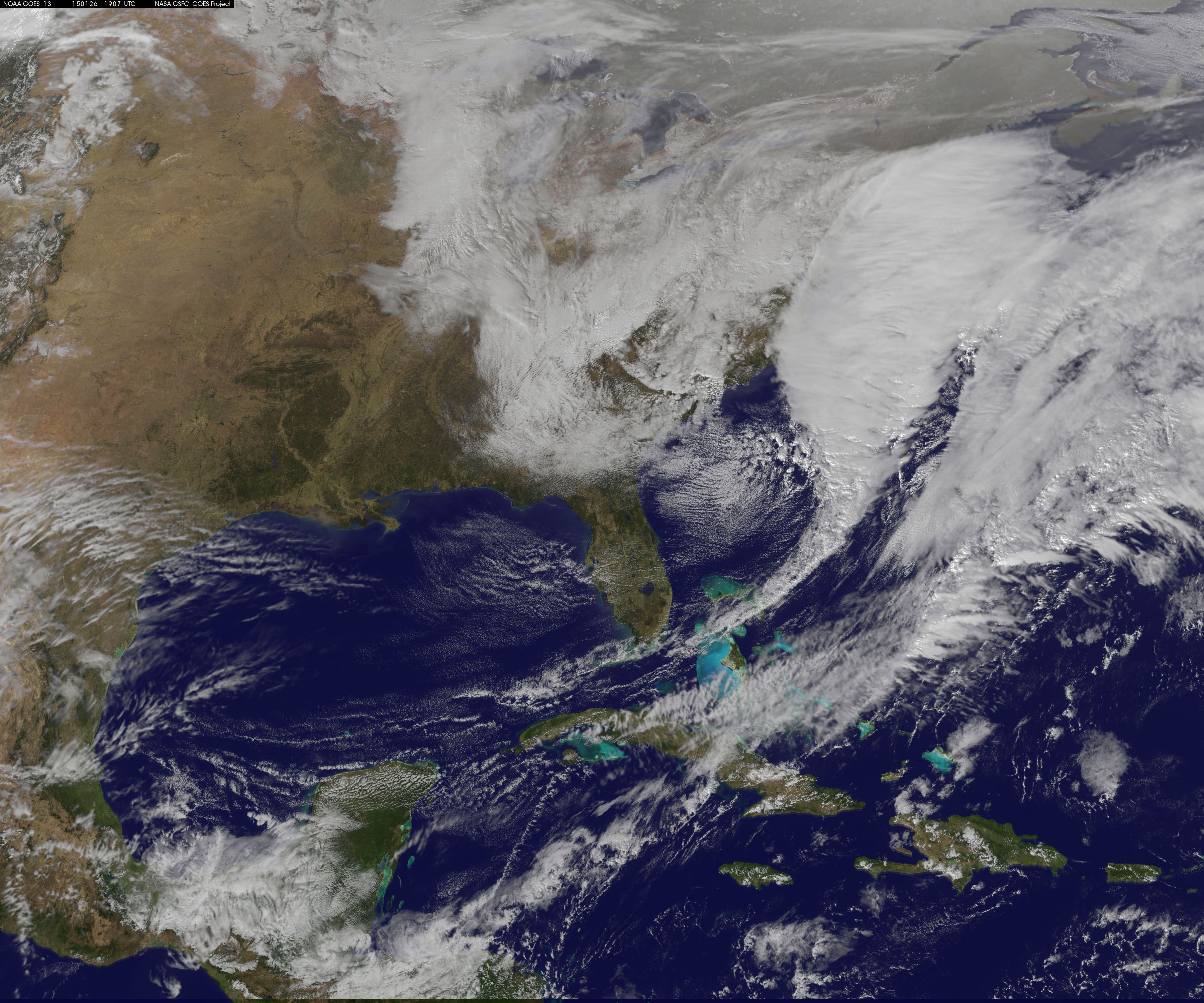
2 pm Visible Satellite
That large expanse of clouds that is hiding the East Coast under there somewhere. At some point this evening the storm center should eventually take on the look of a hurricane with an eye-like feature in the center.
Overall the forecast is going according to plan. If you want all the details scroll down to yesterdays post. But the summary version can be found next:
-Heavy snow moves in after the evening commute tonight. 1-1.5 feet of snow fall between midnight tonight and 8 am tomorrow morning. When all is said in done moset locals will see between 1.5 and 2 feet of snow. Below is the simulated satellite for 4 am tomorrow morning. At this point snow is adding up at 2-3″ per hour everywhere.
4 am Tuesday Simulated Satellite from RGEM
-Heaviest snow ends early Tuesday afternoon. Lingering showers and periods of light snow last through to very early Wednesday morning.
-Widespread wind gusts of up to 50 mph will be felt throughout the region starting early tomorrow morning and lasting throughout the day.
-Power outages are possible everywhere due to the strong winds. Outages are likely across southeast Massachusetts, Rhode Island and Cape Cod.
-Many of the beaches along our coastlines will likely be re-shappen by this system due to its slow moving nature and continuous northeast fetch.
Last pre-storm snowmap is included below. Model guidance is beginning to hone in on a jackpot region for the zone between Boston & Providence. It seems that these locals will likely receive some enhancement due to the coastal front and up to 3 feet of snow is possible here.
There could potentially be another zone where up to 3 feet could fall. This would be from north-central Connecticut northwards through Worcester County and into southern New Hampshire. But this zone is not as immediately obvious as the one across southeast Mass.
When all is said and done this one will likely make it’s mark in the record books and could be a top 5 snowstorm for Portland, Boston, Worcester, Providence, Hartford & New York City.
Total Storm Snowfall Forecast
-Chris
My favorite movie all-time is Twister with Helen Hunt and Bill Paxton. At one point in the movie while at a maintenance garage/hotel for night a tornado is bearing down on them. One of the members of the chase team realizes this and begins yelling: “It’s coming! It’s headed right for us!!”
Well that is how I feel presently. A Blizzard of potentially historic proportions is going to form and take shape off the Mid-Atlantic coastline and slowly drift northeastward bringing with it historic snowfall amounts and widespread potentially damaging wind gusts.
As one would expect, with such a storm bearing down on us the National Weather Service is right on top of things and currently has warnings raised for the entire region ahead of the storm.
Current warnings via NWS Taunton
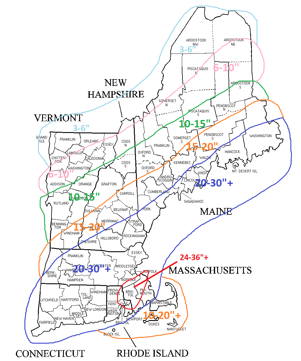
That orange shading is a Blizzard Warning and it basically covers the entire region. Honestly, all of Southern New England will experience Blizzard conditions at times, but for a Blizzard Warning to verify Blizzard conditions must be observed for three consecutive hours. And while Blizzard conditions are likely everywhere I’m not sure the time requirement will verify; hence the entire region not being covered in orange.
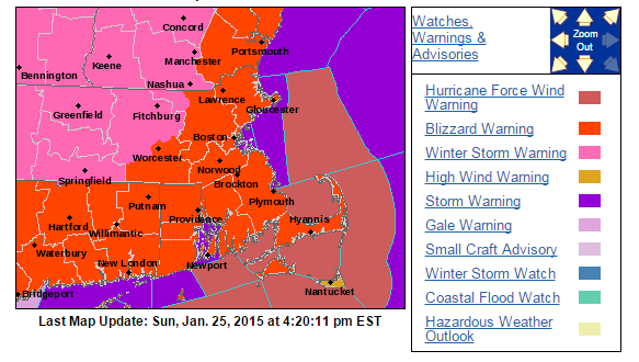
That being said those regions under the pink are under Winter Storm Warnings for excessive amounts of snow falling from this storm. To put numbers on a map, here is the National Weather Service in Taunton’s forecasted snowfall amounts from this system:
NWS Taunton Snowfall Forecast
No your eyes do not deceive you! That dark purple shading is for 24-36″ of snowfall. Meanwhile the lighter shade of purple is nothing to scoff at as that represents 18-24″ of snow. Lesser amounts on the Cape and Islands due to lower snowfall rates and possible mixing.
But how exactly are numbers that historic going to occur? Let me show you.
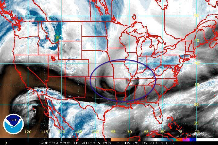
Water Vapor Image
In the image above I have circled our storm system with the purple oval. This storm is making a bee-line from the Canadian Prairies to the East Coast. Over the next 2 to 3 days the storm should evolve as such:
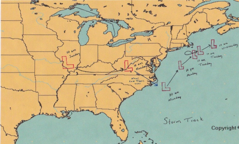
Forecasted Storm Track
Leaving its current location the storm will swing through the lower Ohio Valley. Eventually during the day on Monday a new storm will begin to form off the North Carolina coastline. This storm will track northeast with time; eventually slowing down as it nears Nantucket. I have tried to illustrate it above that during the day on Tuesday it is possible (likely) that the storm center will perform a counterclockwise loop south of Nantucket & Martha’s Vineyard. This is a classic signature in our historic Blizzards including 1978 & 2013.
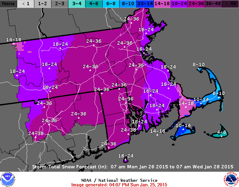
Finally late Tuesday afternoon and overnight into Wednesday the storm will slowly begin drifting east-northeast, but not before unloading all of its moisture and energy on the Mid-Atlantic & New England. For a broader view of possible snow totals see below:
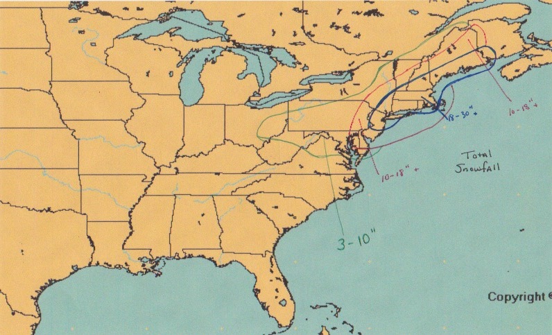
Possible Snowfall Totals
As you can see basically the entire I-95 corridor and adjacent regions from Philadelphia to Bangor are looking at 10″+ of snow. With New York City, Hartford, Providence, Worcester, Boston & Portland bearing the brunt of the storm and possibly seeing snowfall amounts of up to and over 2 feet.
TIMING:
As luck would have it this one aspect of the storm that the models currently differ on. Some models have snow moving in before the evening commute home; while others wait until later in the evening. Either way snow will overspread the area of south to north during the evening Monday. My best guess is that snow overspreads the area anytime after 7 pm. Meaning that the evening commute home should be ok.
By midnight all of Southern New England is in the storms clutches with snowfall rates over 1″ per hour and up to 2-3″ per hour in some spots at times.
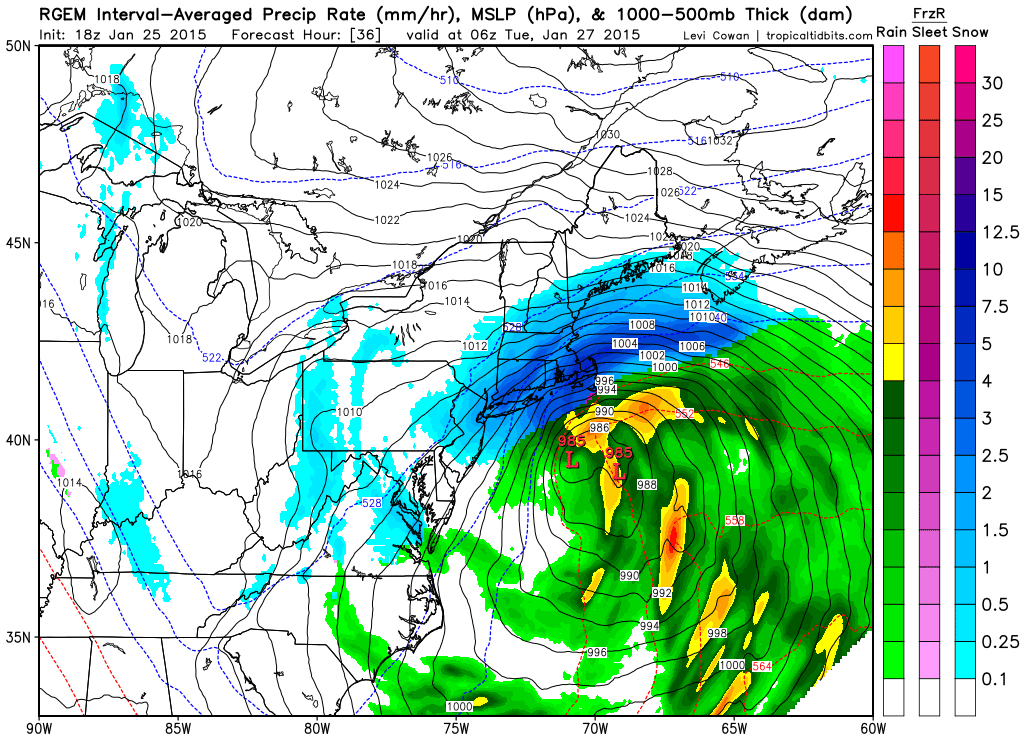
RGEM 1 am
The heaviest of the snow will fall from midnight Tuesday through early Tuesday afternoon. Essentially a 12 hour thumping where 1-2 feet of snow fall.
By 1 pm Tuesday the storm will be running on fumes. Just like any kind of engine a storm only last as long as there is fuel. By early Tuesday afternoon the storm will be in its dying stages. Snow will becoming more light & scattered in nature, but could still be heavy at times. As you can see from the image below the shades of blue have become lighter and the precipitation shield is begining to become more ragged.
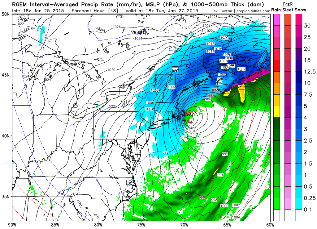
RGEM 1 pm Tuesday
That isn’t to say that the storm will be completely done at this point. It will still be lingering just east of the Cape and winds will still be gusting to near 50 mph at times.
Finally very early on Wednesday morning the storm will have pulled far enough away that we will finally be able to bid ado to our storm system.
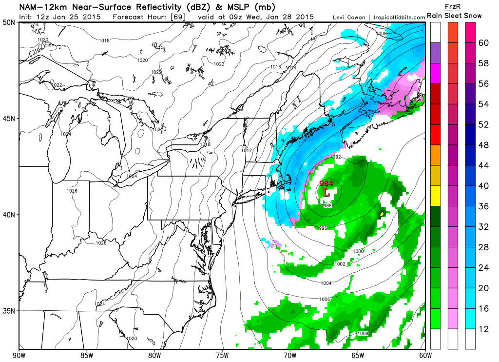
NAM forecast 4 am Wednesday
Recap: Snow overspreads the region Monday evening after rush hour. Snowfall rates greater than 1″ an hour or greater can be expected from Midnight Tuesday through the early afternoon. Light snow and gusty winds from Tuesday afternoon through very early Wednesday morning.
WINDS:
Unlike our last storm on Saturday this one will feature and area of high pressure just north of the border in Canada. The co-location of a strong high pressure with a rapidly intensifying low pressure center should allow for the winds in this storm system to become quite impressive.
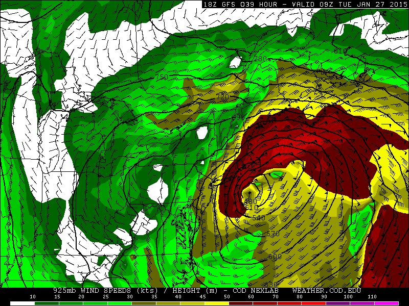
GFS 925 mb Winds 4 am Tuesday
The above image represents the 925 mb for 4 am Tuesday morning with wind speeds at 2000 ft above the ground nearing or greater than 50 knots (58 mph) for all of eastern SNE. These winds will be able to mix down to the surface frequently throughout the hours of heaviest snowfall. Wind gusts for much of SNE could be as strong as 50 mph. Nearer the coast wind gusts on the order of 60-70 mph are possible. And along the shoreline winds nearing hurricane strength are possible.
The period of strongest winds could be quite long due to the storms very slow movement. For example the following image shows nearly the same wind set-up as above, just 15 hours later with the region of highest winds slowly pulling away.
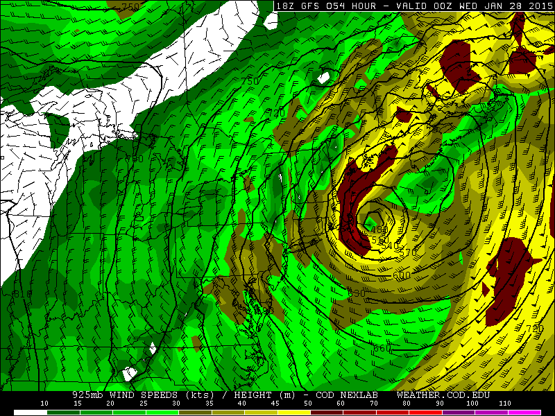
GFS 925 mb Winds 7 pm Wednesday
TIDES:
Luckily the astronomical high tides have past for this month, but with such a slow moving system and continuous northeast winds water should begin to pile up along the coastline. Coastal flooding can not be ruled out with this system. Especially in those locations that always seem to flood (Revere, Nahant, Scituate).
SNOWFALL:
And finally what everyone is looking for the snow map. If you have been reading this far I won’t bore you anymore.
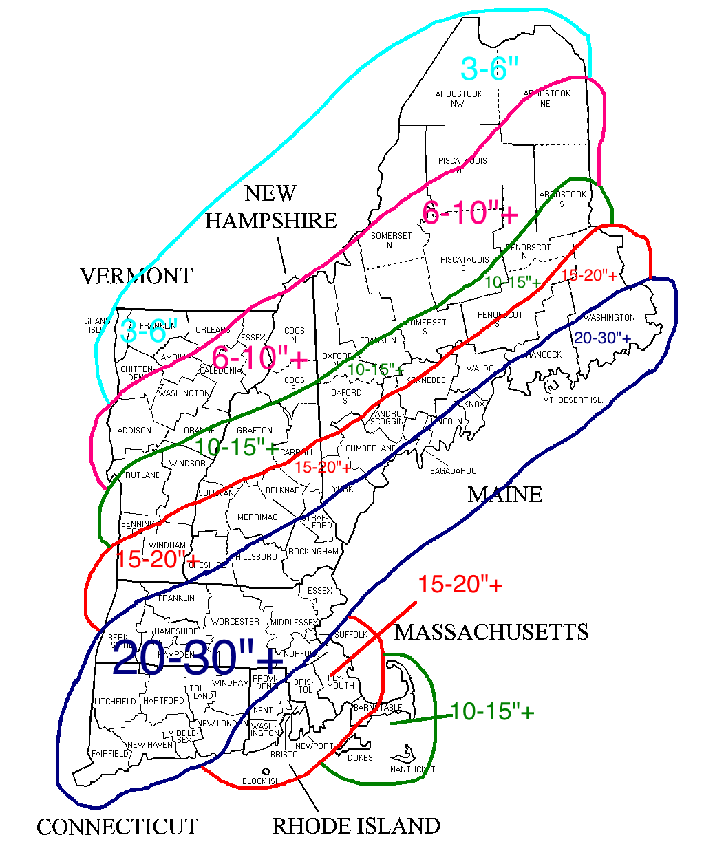
Expected Snowfall
I’m expecting a wide spread swath of 20-30″ of snow for much of Southern New England and coastal Maine. As you approach the Cape and Islands the forecast totals go down due to lower snowfall ratios and possible mixing at times.
North and west of the jackpot zone amounts will lessen the further north you get simply due to the lowering amounts of precipitation.
All in all this could be one for the record books. Snowfall rates such as this are reserved for the top all-time snowstorms in Southern New England history. If all goes according to plan; 1888, 1978, 2005, 2013 will all have company among the greatest snowstorms in region history.
-Chris
Earlier this week I posted a blog in which I highlighted two potential storm chances; the first being Saturday (today) and the second to follow on Tuesday. As the models tried to hone in on a solution for today’s event they began to struggle with figuring out the forecast for Tuesday. Which is easy to understand when one considers that the outcome of Tuesday’s event would be greatly effected by the outcome of Saturday’s event.
Well last night with the outcome of today’s storm all but decided the New England weather community was treated to an outstanding model run from the European computer model. Seeing last night’s European model advertise a long duration major nor’easter was quite entertaining and was met with a “Hey that’s kind of nice” attitude.
Until this morning when the first model of the morning came in with a nearly identical solution to the overnight European run. Below is the model forecasted total snowfall from the 7 am run of the NAM computer model courtesy of Tropical Tidbits. All images courtesy of Tropical Tidbits.
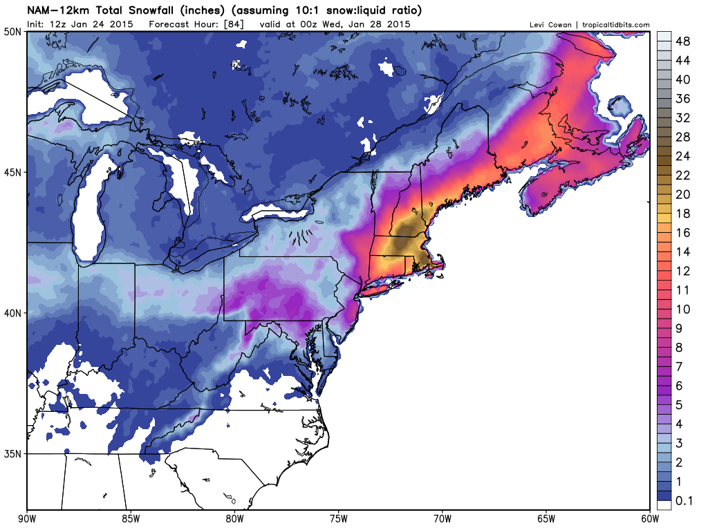
Snowfall Forecast through 7 pm Tuesday
Based on the image above everyone who lives under or inside of the yellow shading would see 16-18″ of snow or more. The darker shades are the regions that based on this model that would receive upwards of 20-22″ of snow.
The fun for this morning was just getting started following the NAM. Below is the morning run of the GFS. Which had the storm passing a bit further east of the area. Leading to the higher totals along the coast versus being more widespread.
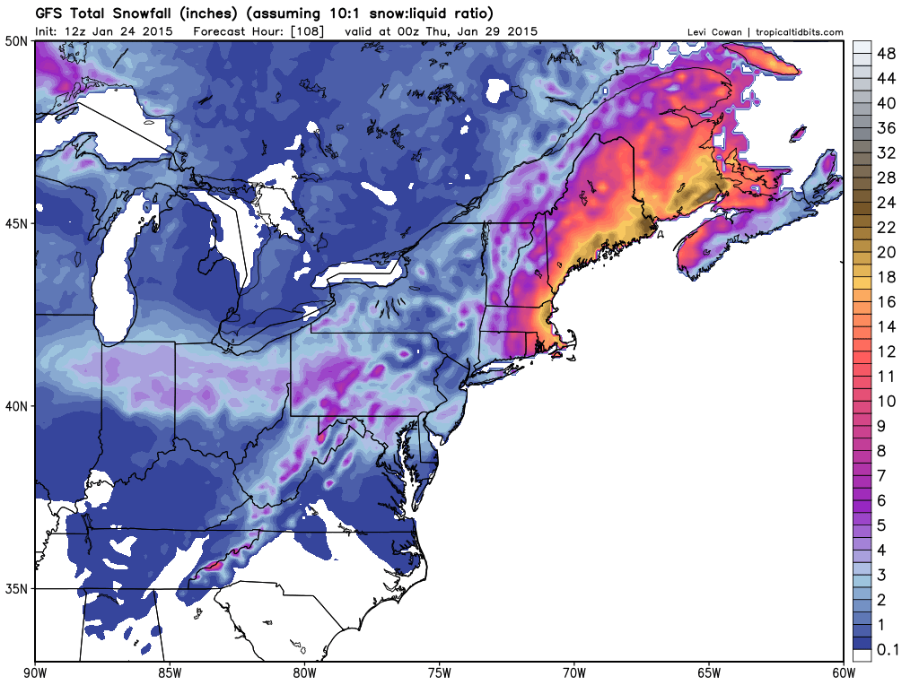
12z GFS Snowfall
But this model in particular has been trending back to the west for atleast two days of model runs. This trend back west only continued with its afternoon run. See the snow map below which gives all of New England nearly a foot or more.
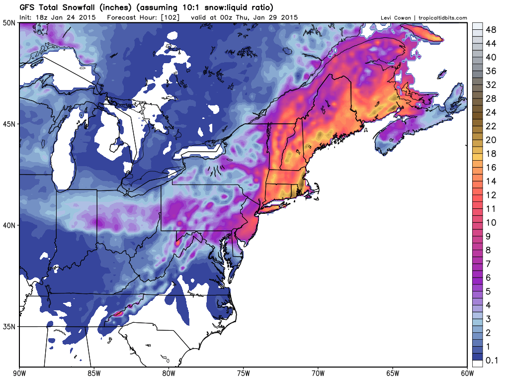
18z GFS Snowfall
Want more? How about the Canadian? It too puts out very similar snowfall amounts for the region.
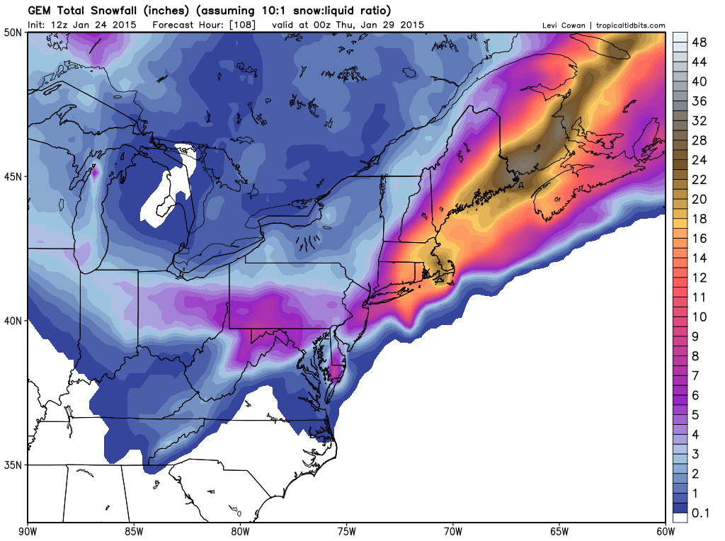
12z CMC Snowfall
Alright do I have you attention yet? Let’s get a little more detailed.
Storm Evolution:
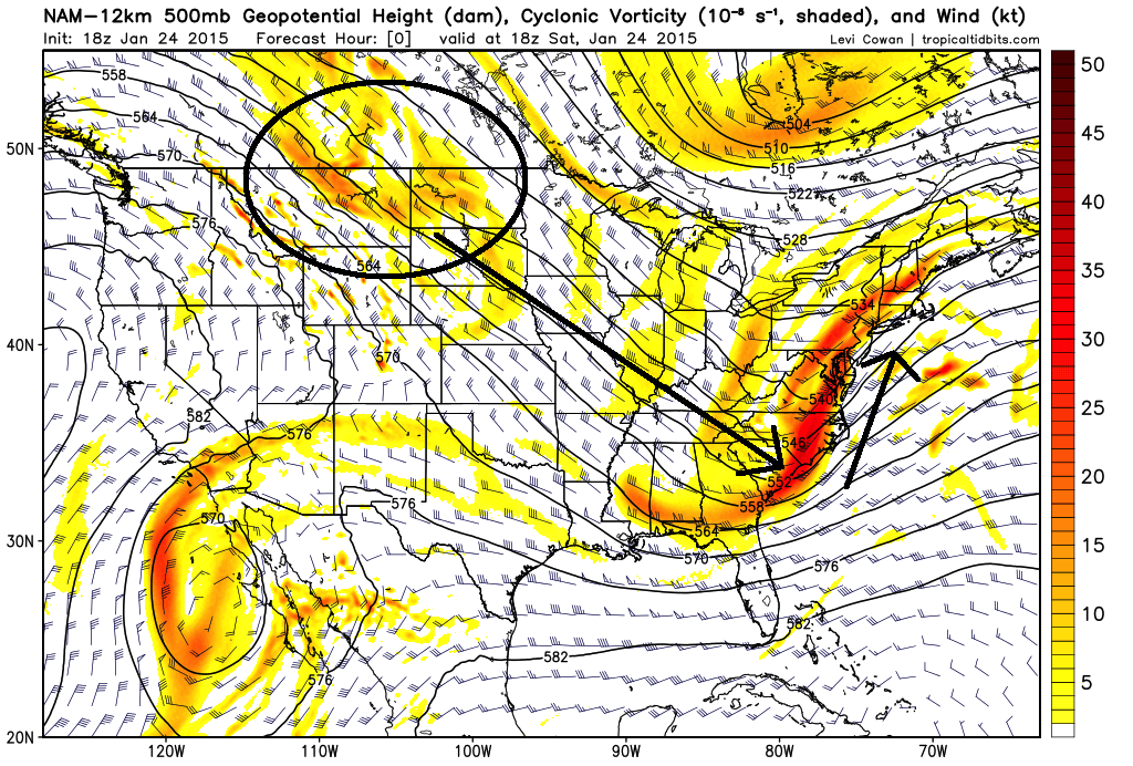
18z NAM 500 mb Vorticity Initialization
Nor’easters and storms don’t form randomly. To create a storm you need energy to drive the system. In the image above the yellow and red shaded regions represent vorticity at the 500 mb level of the atmosphere. When we think of vorticity, we can think of energy. And for our Tuesday event the energy that forms our storm is that region of energy I have circled over Montana, North Dakota and southern parts of Manitoba and Saskatchewan. This energy is going to beline for the southeast coast before turning north up the East Coast.
Once this energy reaches the coast a storm center will begin to form off the Carolinas. The image below represents the storm taking shape before moving north.
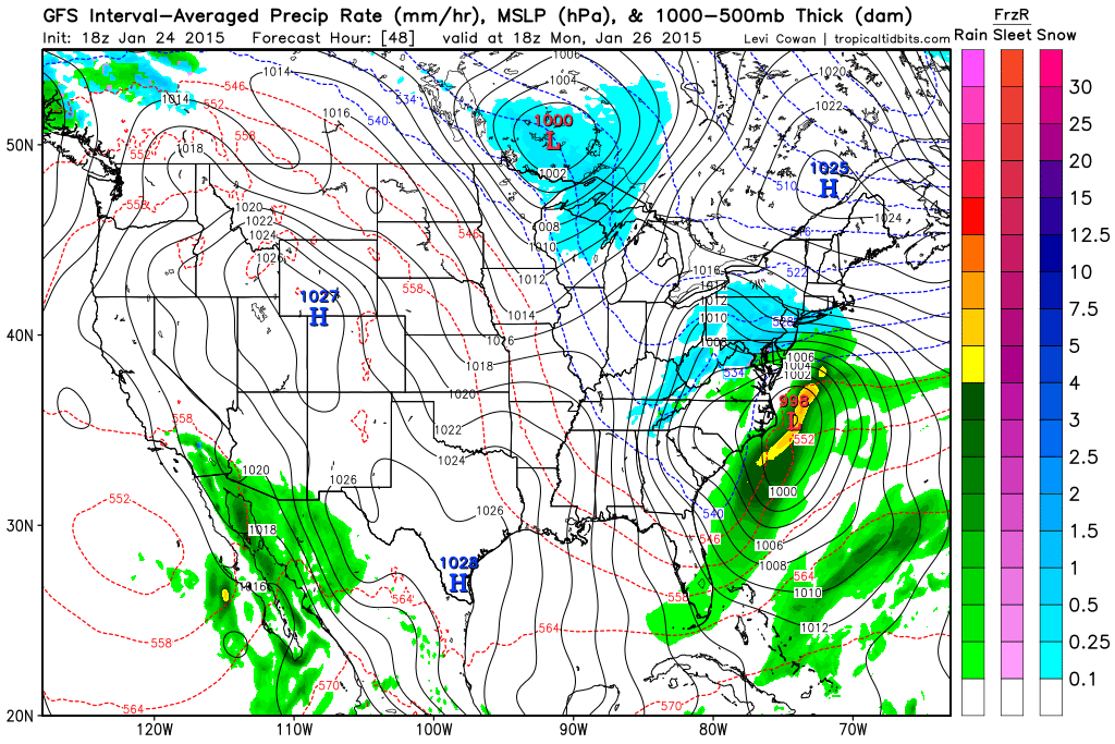
18z GFS Forecast for 1 pm Monday
From the Carolina coast the storm will slowly move north before passing slowly southeast of Southern New England.
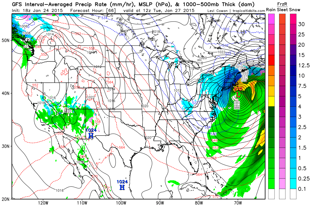
18z GFS Forecast for 7 am Tuesday
One thing that is becoming evident about this system is going to be its slow movement. At about the same time that the storm is going nuts south of Southern New England, the upper level energy will be attempting to capture the surface reflection. When that occurs the storms forward motion really slows down and often times the storm center will almost perform a loop south of us. Many of our biggest storms have performed this loop including the Blizzard of 1978 and the February Blizzard of 2013 (Nemo).
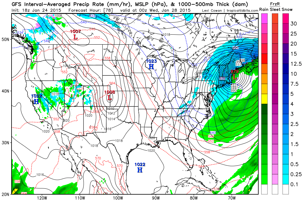
18z GFS Forecast for 7 pm Tuesday
It isn’t until 7 am Wednesday morning that the storm center and snow finally pulls away from Southern New England based on this model run.
18z GFS Forecast 7 am Wednesday
Wind:
Can’t have blizzard conditions without wind can you? The image below is the NAM representation of the 850 mb winds during the height of the storm. The image shows winds that are a couple thousand feet off the ground of 60 to 80 knots. Due to the intense nature of this system wind gusts on the order of 50 mph should be able to reach down to the surface. At the same time winds nearing hurricane strength will likely be battering the coast lines.
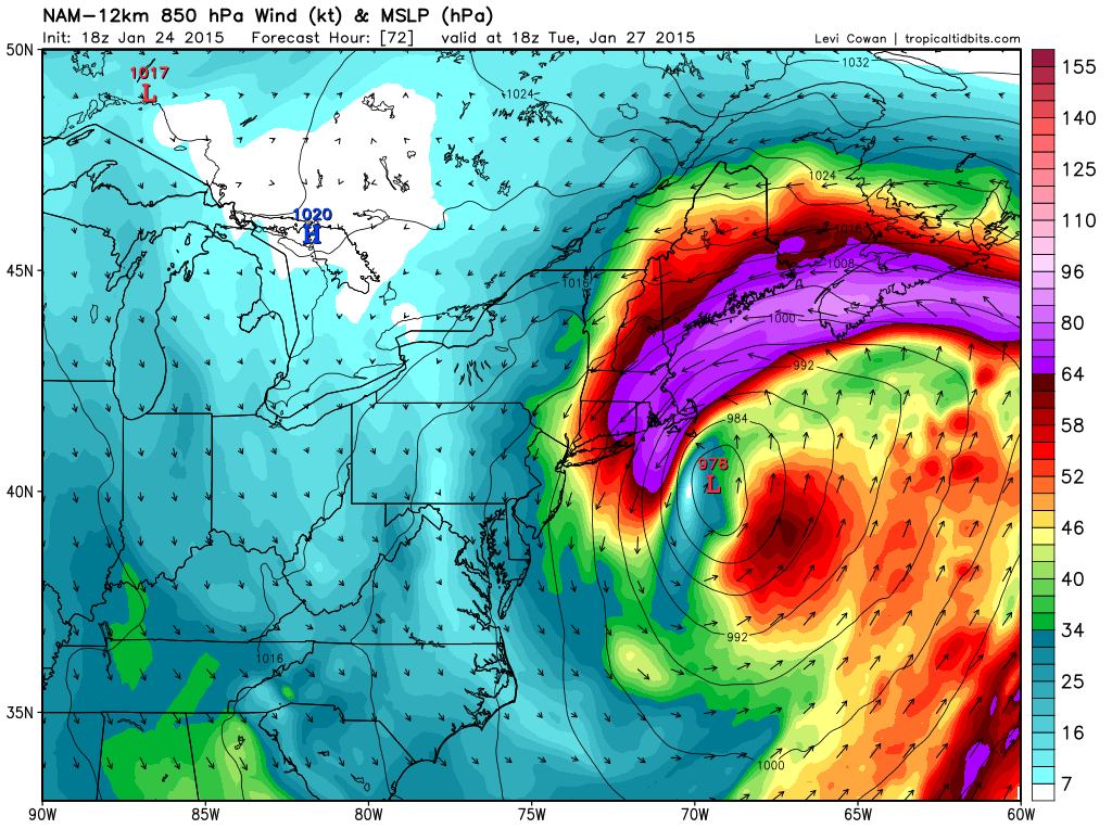
18z NAM 850 mb Wind for 1 pm Tuesday
Timeframe:
Along with snowfall the start and end of the storm is in flux right now. If I had to put a time one it I would expect snow to start overspreading the region around midnight Monday into Tuesday and last through the day Tuesday. Eventually winding down sometime around midnight Tuesday into Wednesday.
Snow Amounts:
Based on the images at the beginning of the blog it looks like most locations should be able to expect at least a foot of snow. I feel this is a good baseline to start with and we can adjust totals from there (likely up).
Recap:
Major winter storm coming for Tuesday. Blizzard conditions are likely at times across much of SNE and Maine. Right now a foot or more of snow is looking likely for all.
Next blog post will likely be late tomorrow afternoon and evening. I will likely have a snow map out with that one.
-Chris
By now I am sure that you have heard that a storm is coming for tomorrow. I mentioned it back on Tuesday and over the last few days things have become a bit clearer, but never really become as clear as one would hope.
The threat of a storm is there, but this one comes with a lot of tricky details that really won’t be realized until after the storm is underway.
Of importance to this forecast are the storms track, push of mid-level warmth and the expansion of the precip shield on the northwest side. If one or all of these don’t go according to plan then this forecast will be a major bust. But then again that is the fun of making a forecast. Trying to predict something that ultimately we really can only make an educated guess at.
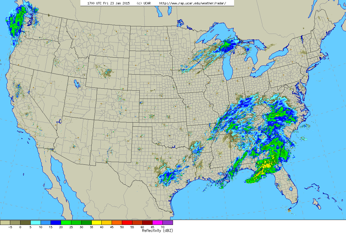
Current US Radar. 12 EST Friday
Currently our storm is the unorganized looking batch of showers and storms over the southeast states. As this system moves northeast and exits the North Carolina coastline it will begin to organize and rapidly intensify. As the storm’s center passes just southeast of Nantucket it should through back enough moisture to give much of Southern New England some snow during the day on Saturday. Starting around dawn snow will break out for much of SNE. As the storm nears places south of the Mass Pike and inside of 495 should experience a period of sleet and/or plain rain. But once the storm really starts to intensify, everyone should eventually flip back to snow sometime during the afternoon.
One key ingrediant is missing with the current atmospheric set-up and that is an area of High Pressure to our north. Without this high pressure temperatures in the middle levels of the atmosphere should warm to a level that snow will change to sleet or rain for most at some point Saturday. Eventually though cold air will wrap back into the storm and the flip back to snow will occur.
The storm is out of our hairs by Saturday night allowing for the clean up to begin.
Now let’s get to the point that everyone cares about. How much are we getting. See the map below. I would like to state that this is quite a low confidence forecast. Especially for the three and five inch regions of Southern New England. Reason being that if we fail to see the push of warm air aloft, then snow totals in these areas will bust low. But then again on the northwest side of the forecast, if the precip shield does not evolve as currently thought, those numbers will bust high.
But hey, what does it matter? We weather men and woman are never right anyways……
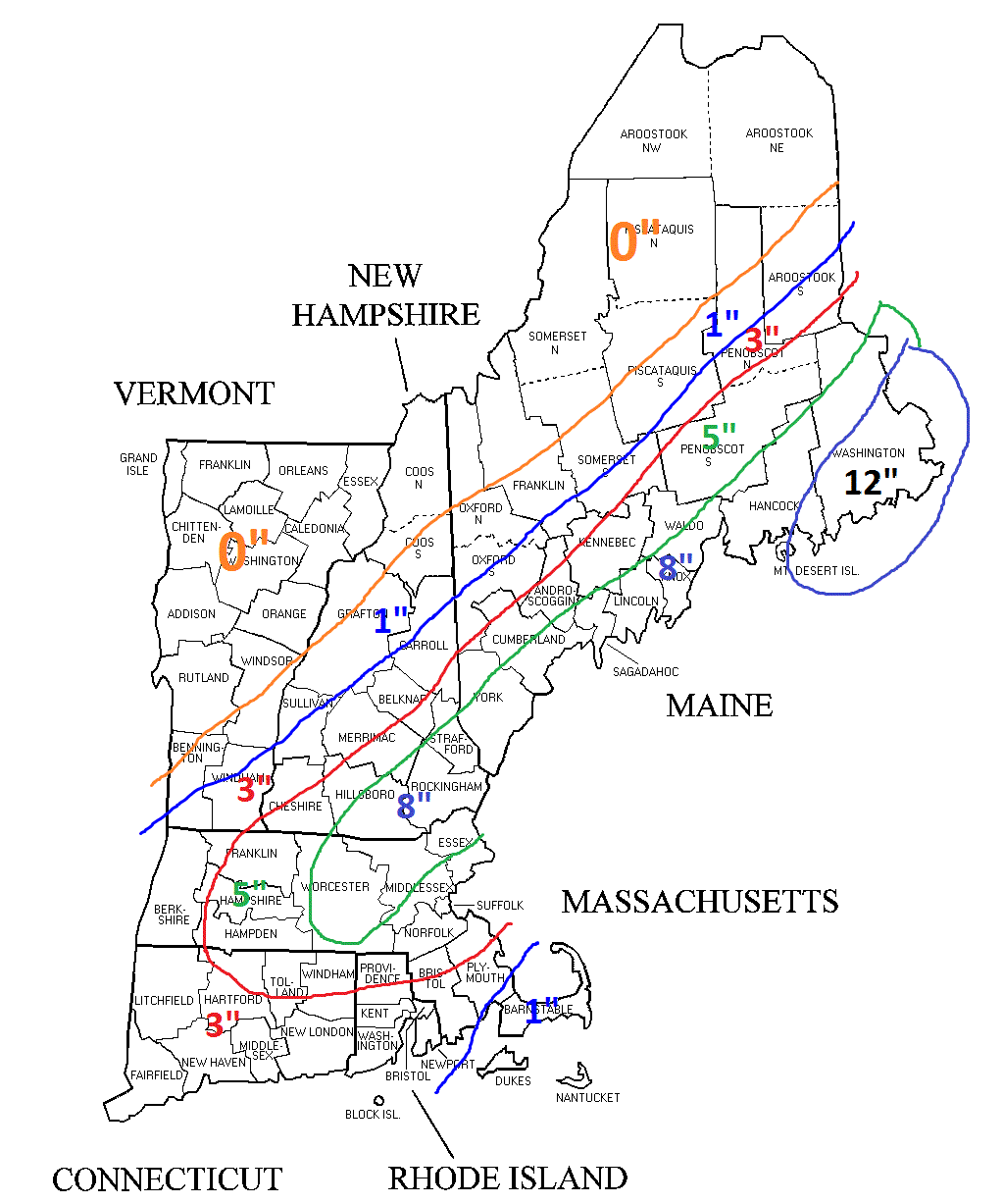
Total Snow Accumulations
-Chris
Raise your hand if you have been wondering where the heck all of the snow has been this winter? Just like every single one of you that raised your hand I too have been wondering where the snow has gone. The theme in the computer guidance this year has been to advertise a storm system around the Day 7 timeframe, but never have it come to fruition.
But it appears that things may be about to change. The computer guidance is advertising two storm threats over the next 7 days that could in the end bring significant impacts to the Southern New England area.
The first storm system is set to begin taking shape along the Gulf Coast states on Friday. See the image below courtesy of Levi Cowen over at Tropical Tidbits.
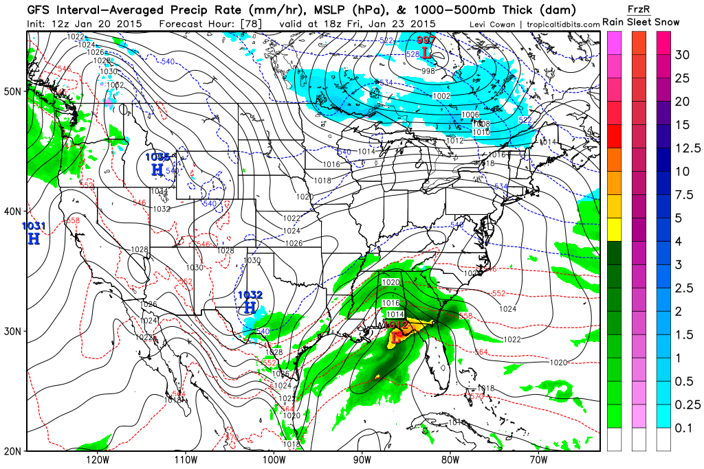
1 pm Friday Afternoon – GFS
Eventually this storm system will traverse the Southeast states and exit the North Carolina coastline and track northeast passing south and east of the island of Nantucket overnight Saturday into Sunday. See below:
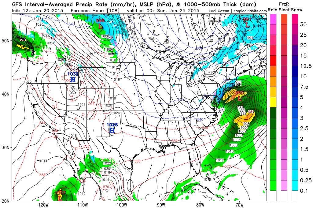
7 pm Saturday Night – GFS
The real question is: will the storm pass close enough to SNE to bring significant impacts? As currently modeled the storm looks to impact southeast MA, Cape Cod and the islands. But it is so close to being so much more for the rest of SNE that is absolutely needs watching.
If the storm track were to shift 50-75 miles west over the next 4 days (very possible) then all of SNE (away from the coast) would be looking at an extremely intense 12 hour snow blitz Saturday night.
But since we are 4 days away from the possible onset of the system, many details can change and the eventually outcome is far from being known. At this time, the Saturday night timeframe just bears watching.
Saturday night isn’t the only storm threat on the horizon though. Following Saturday’s potential is an equally potent set-up for Tuesday. As our weekend storm exits northeast into the Canadian Maritimes a potent piece of energy associated with a clipper type system will drop southeast across the midwest and beline for the mid-atlantic coast line.
Once the system begins to sniff out the warm waters off the East Coast a new area of low pressure will begin to take shape off the Carolina coast.
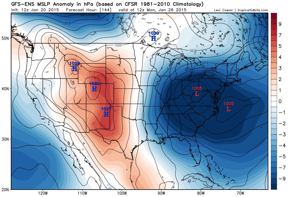
7 am Monday – GEFS
From here the low should track north-northeast passing just east of Nantucket during the day on Tuesday.
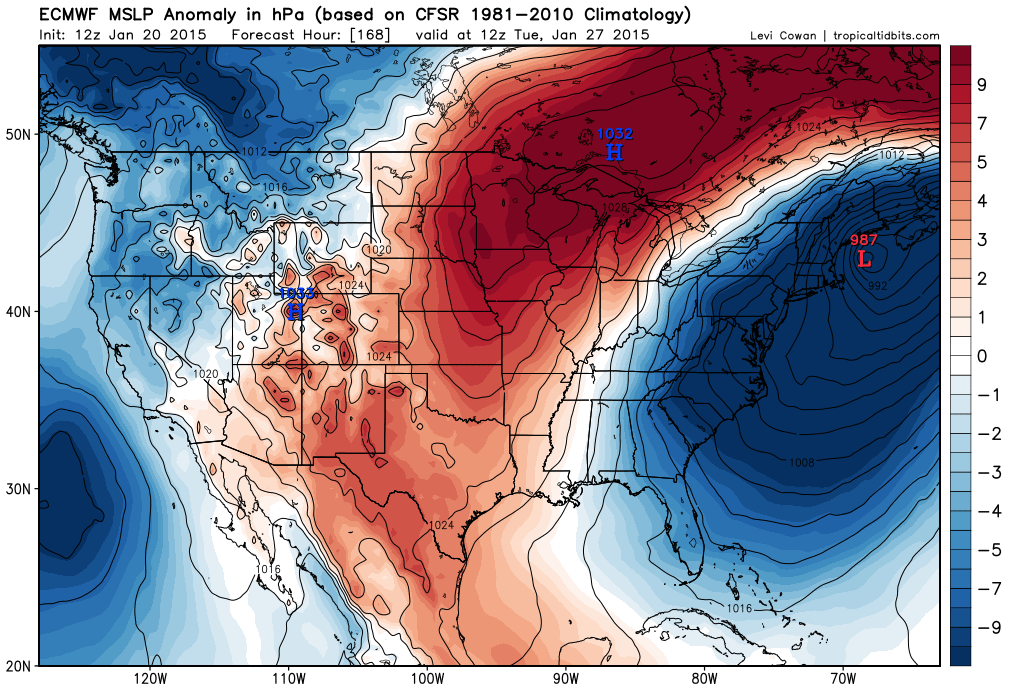
7 am Tuesday – ECMWF
The purpose of this post is to just highlight the potential that for storminess in the next 7 days. Right now it appears there are two CHANCES for snow in the forecast. First being Saturday night with the second coming on Tuesday. Meaning that these two chances are 4 and 7 days away respectively. A LOT can change in that amount of time. All we can say now is that there is a CHANCE.
But being honest, these two storm threats are the best that we have seen all winter long with both having the potential to bring significant impacts to the region.
Only time will tell so stay tuned.
-Chris
