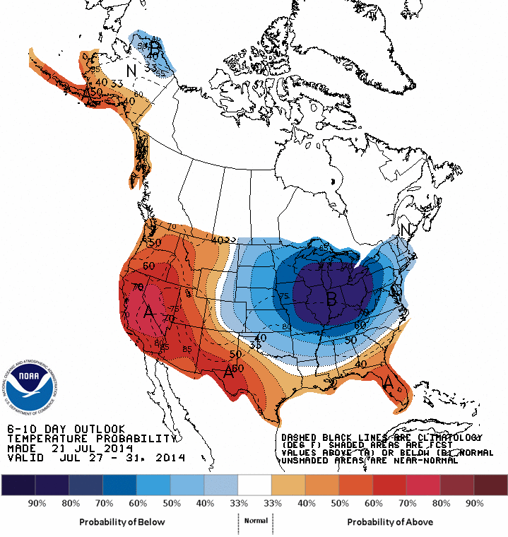
CPC 6-10 day Temp Anomaly Outlook
The image above is the 6 to 10 day temperature anomaly outlook from the Climate Prediction Center. The outlook shows that the upper Midwest, Great Lakes and Northeast are looking at a period of below normal temperatures moving in. As air from central and northern Canada invades the eastern half of the country daily temperatures should fall a few degrees below normal. Which can be seen in the 7 day where as we get into early next week afternoon highs are in the upper 70s to near 80.
But before we get to this period of comfortable temperatures we have to go through a couple of rather warm days starting today and carrying into tomorrow. Todays highs will reach for 90 and tomorrows will reach into the 90s with a few locals possibly coming in upwards of 95. All of this ahead of a cold front that is slowly sweeping its way across the upper Midwest.
As the cold front approaches New England showers and storms will enter the forecast beginning late tomorrow afternoon/evening as storms that fire way to our west attempt to make it into Southern New England during the late evening hours. Northern New England has the better chance for storms on Wednesday where a few storms may be severe as shown by the image below from the Storm Prediction Center who feel that there is a slight risk (15%) chance of a severe storm across portions of Maine, New Hampshire & Vermont.
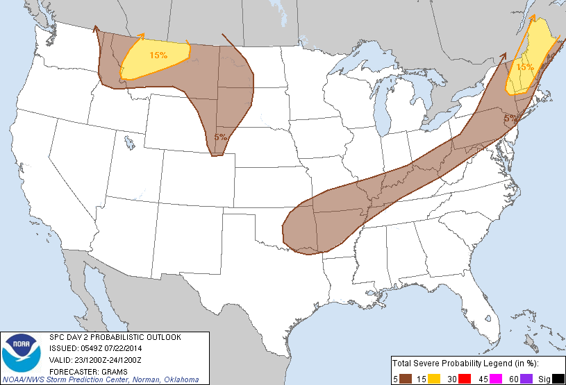
Day 2 Severe Outlook from SPC
The better chance of showers/storms comes during the overnight hours in Southern New England and likely into the morning hours of Thursday. Depeding on the eastward progression of the cold front afternoon storms are possible across far eastern portions of New England Thursday.
After the front moves through much cooler air will return and set us up for a string of rather nice days beginning likely with Thursday and lasting until Sunday. Then say from late Sunday through early next week showers and storms will be possible as an upper level disturbance from Canada moves in. This is the same disturbance bringing cooler temps with it. And with those cooler temps comes the chance for rain.
Wednesday: Chance of a late evening shower or storm. Storms possible overnight. Afternoon highs 90 to 95. Winds gusting 10-20 at times.
Thursday: Morning sprinkle possible. Afternoon showers possible along south coast/Cape & Islands. High temps in the upper 70s to near 80.
Friday: Highs near 85.
Saturday: Afternoon highs in the upper 80s.
Sunday: Showers and storms likely. Highs in the mid to upper 80s.
Monday: Isolated showers and storms. Highs in the upper 70s to near 80.
Tuesday: Showers and storms possible. Highs around 80.
-Chris
