TODAY
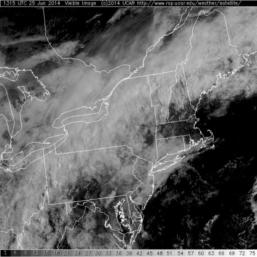
Current Visible Satellite
Today is starting out mostly cloudy for much of the northeastern portion of the country except here in central and eastern southern New England where we have mostly clear skies and bright sunshine. The clouds off to our north and west are the result of a frontal system that is draped along the Canadian border. This front is going to slowly drop south and east throughout the day.
Heavy rain will develop during the day today throughout Northern New England and will last through Thursday morning. The rain shield will be slow to drop south and east and will likely not make it into most of Southern New England. However that does not mean that Southern New England will be totally dry. Down here in Southern New England we will have the threat of thunderstorms during the afternoon. Some of these storms could be strong to potentially severe. The Storm Prediction Center has given portions of western and central New England a 5% chance of a severe wind report. On a personal note I have still not experienced a thunderstorm this year. I am having withdrawals.

NAM Total Precip 11 am Thursday
The image above is the forecasted total precipitation from the NAM model through 11 am Thursday morning. As you can see the bulk of the precipitation falls across Northern New England with most locations receiving 1-2″ of rain and some spot locations forecasted to get 3-4″.
As for our temperatures today, across Southern New England our temps will warm through the 80s and reach to either side of 90. Looking at the High Resolution Rapid Refresh Model (HRRR) temperatures in portions of SNE reach into the 90s.
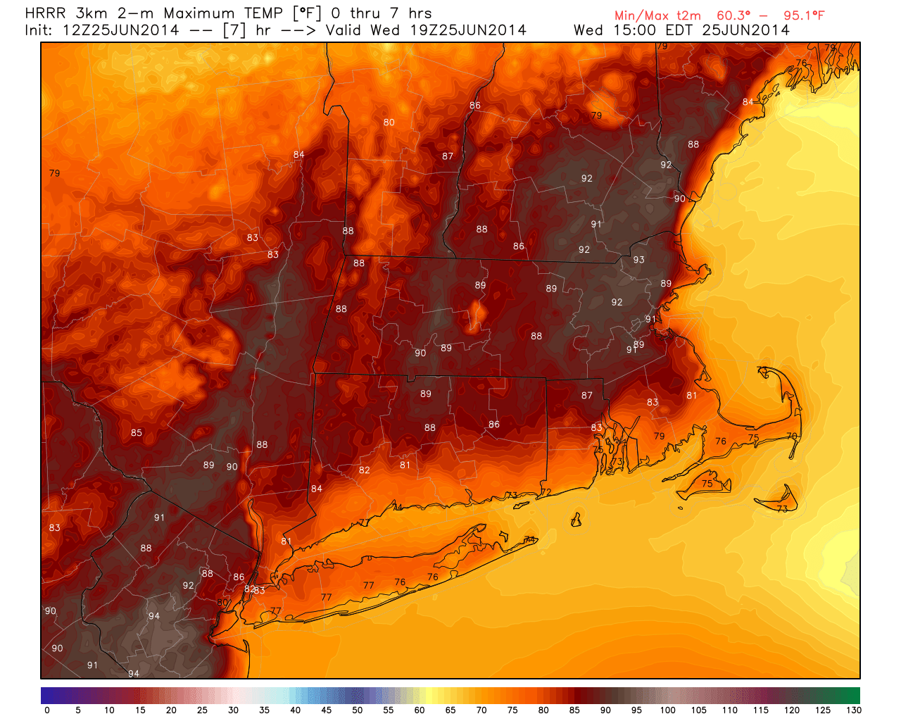
HRRR Forecasted Highs courtesy of WeatherBell
Based off the HRRR it appears that we here in SNE need to keep an eye to the sky after about 6 pm as thunderstorms slowly drop south and east. Thunderstorms should persist into the overnight, but should move through by daybreak.
REST OF THE WEEK/WEEKEND
Thursday: Morning showers move offshore. Chance of a pop up shower or storm across SNE during the afternoon. Afternoon highs in the mid-70s; mid-60s in Maine where the rain hangs on a bit longer.
Friday: Mostly sunny with highs near 80. Definitely a beach day.
Saturday: Mostly sunny with afternoon highs 80-85. Watching for a seabreeze along the South Coast to keep temps a bit cooler.
Sunday: Mostly sunny with highs in the mid to upper 80s. 70s along the South Coast.
EARLY JULY
The first portion of July is looking warm around here. The image below is the 2 meter temperature anomaly for the period of time from June 30th to July 5th. Here in New England the period of time looks to average about 4 degrees above normal across the Northeast. Meaning that with an average temperature of 80 degrees for the first week of July, we should see temperatures in the mid 80s instead of the low 80s. This doesn’t mean that a few warmer days can not be ruled out. I’m sure that we can get a few smaller scale features to turn an 85 degree day into a low 90s day. Just something to think about going forward.
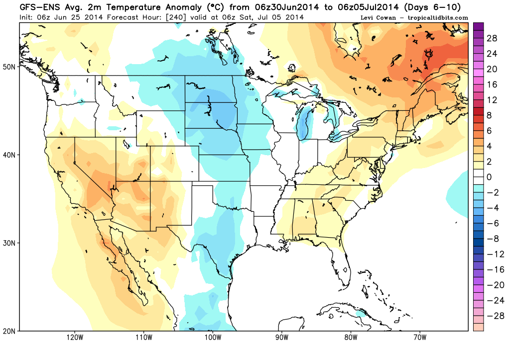
Day 5-10 2m Temp Anom. GEFS via Tropical Tidbits
At the same time the Mean Sea Level Pressure maps from the Global Ensemble models appear to be advertising below normal pressure levels. Which means that in addition to it being hot to start the month of July, weather looks to be unsettled as well. Likely in the form of pop up showers and thunderstorms.
HURRICANES
Hurricane season is off and running…….well maybe it is crawling. Through almost the first month of hurricane season the Atlantic has been sleeping.
Atlantic Overview from NHC
Nothing is expected at this time and this could be a common theme throughout this season. Currently NOAA has issued an El Nino watch for the possibility of an El Nino developing in the eastern tropical Pacific. They are forecasting a 70% chance that an El Nino develops this summer with the likelihood increasing to 80% for the fall and winter. Late summer and fall is the peak time for Hurricane development across the Atlantic. However, El Nino’s tend to limit the amount of tropical development in the Atlantic Basin.
The Colorado State Department of Atmospheric Sciences has been publishing their seasonal hurricane forecast for years and this year they are predicting below average activity in the Atlantic. As of June 2nd they are forecasting for 10 named storms (average is 12) with 4 hurricanes (average is 6.5) and 1 major hurricane (average is 2).
In agreement with the Colorado State group the National Hurricane Center is forecasting a 50% chance of a below normal season and a 40% chance of a near normal season.
But it is always important to remember that is only takes one damaging hurricane to make a seaosn and to ruin lives.
-Chris
Tropical downpours have overspread the region this morning and will continue to do so for the rest of the day. Downpours become more scattered overnight and linger through till tomorrow morning.
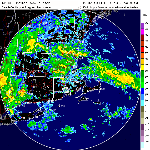
11 am Radar Image
While our weekend starts out dreary today and early tomorrow morning, Saturday afternoon will feature clearing skies after the passage of a cold front and Sunday is looking spectacular for all of the Dads out there.
Friday: Numerous downpours during the day. Some locals could see some localized street flooding if a downpour sits over one place long enough. Afternoon temperatures reaching into the mid 60s.
Saturday: Scattered shower during the morning as the cold front moves through. A rumble of thunder is possible. After the cold front pushes offshore winds will switch around to out of the northwest and will help to usher in cooler and less humid air. Afternoon temperatures on Saturday will reach into the low 70s.
Sunday: All of the Dads out there should enjoy this one. Get out and play a round of golf (if you can find a tee time). Other than a few fair weather high clouds this day should be perfect. Afternoon temps in the mid to upper 70s with only a slight breeze.
Next Week: Looking ahead to next week, other than Wednesday the week looks wonderful. Monday through Wednesday will feature increasing temperatures. 70s on Monday followed by 80s on Tuesday and finally mid 80s on Wednesday. A cold front will be on approach on Wednesday and the afternoon will feature showers and storms. After the front passes we hit the repeat button. Thursday and Friday will be nice with temperatures on the rebound.
Enjoy the weekend and the upcoming week.
-Chris
If you were looking for the weekend of the year, then this might be the one. This mornings rain has pushed offshore and in fact the sun as come back out. The storm system that produced todays rain will drift off to the northeast and linger near Nova Scotia. Unfortunately for the state of Maine this means that clouds and chances of rain will linger through the weekend.
For the other 5 states in New England high pressure near the Great Lakes will drop in and provide what is going to be a most excellent weekend. Now that we have reached the month of June we have entered Meteorological summer (June 1 – August 31) and this weekend looks to be the first true beach weekend of the summer. After a mostly cloudy start on Friday as today’s storm drifts northeast the rest of the weekend should feature few clouds and ample sunshine. Afternoon highs on Saturday and Sunday should reach into the mid-80s; even at the shore as the wind direction will be out of the northwest.
The following three images are the daily forecast maps from the Weather Prediction Center for this weekend.
Daily Forecast Map for Friday
Daily Forecast Map for Saturday
Daily Forecast Map for Sunday
The three images are helpful in that they depict the two synoptic features in play this weekend very well. The low pressure center that brought todays rain that slowly drifts northeast and lingers near Nova Scotia. And the high pressure center that drifts east from the Great Lakes that provides the excellent conditions for this weekend.
ENJOY!!
Weekend Forecast
Friday: Mostly cloudy to start, but becoming partly cloudy with high temperatures 70-75. Northwest winds at 5-10 mph.
Saturday: Few clouds with afternoon highs near 85. Northwest winds 0-5 mph.
Sunday: Few high clouds moving in with afternoon highs near 85. Southwest wind 5-10 mph.
Next Week: Warm to start with highs in the mid 80s on Monday; chance of an afternoon storm. Tuesday brings cooler conditions with highs in the low 70s. After that the rest of the work week will feature highs either side of 80 with a chance of a shower or storm on Wednesday and Friday.
-Chris
