Does everyone remember the wonderful stretch of weather that we had this past weekend and Monday? Three straight days with afternoon highs in the 80s and finally the mid to high 80s on Monday.
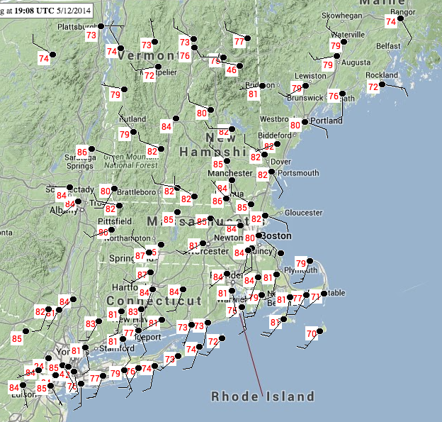
5/12/14 High Temps
Then remember waking up on Tuesday to temperatures never getting out of the low 50s on Tuesday? Waking up wondering what the heck happened to that wonderful stretch of weather and questioning how we could swing from near 90 to barely above 50 in under 24 hours.
Such a drastic change was due to a backdoor cold front that moved through Southern New England late Monday night and very early Tuesday morning.
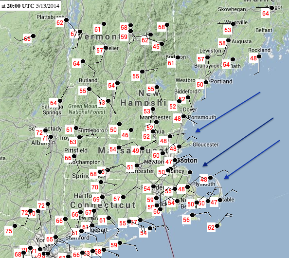
3 pm 1/13/14 Temps
Comparing the two images above there was an obvious change in wind direction. Well a wind direction change is associated with the passage of a frontal boundary. This frontal boundary was a cold front and it just so happens that this cold front came from an unusual direction. Instead of traversing New England from west to east like the majority of our weather systems due; a backdoor cold front moves from northeast to southwest across eastern portions of New England bringing cooler Gulf of Maine air with it.
Backdoor cold fronts are not that uncommon across our portion of the country. Heat waves are often ended by a backdoor cold front. And while three days in the 80s doesn’t qualify as a heat wave; Monday night’s backdoor cold front did end a three day stretch of temperautres that could be considered warm for May.
To show you how this version of a backdoor cold front formed let me present to you the Daily Weather Map graphics from the Hydrometeorological Prediction Center. The first one will be from Monday where highs were in the upper 80s. The second one will be from Tuesday where our temperatures struggle to remain in the low 50s.
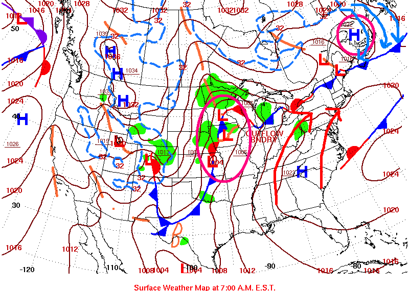
5/12/14 Daily Weather Map
In the image for Monday I have circled the two main synoptic weather systems that were in control of the weather across New England. Circled are a developing area of low pressure across the Northern Plains and a high pressure center located across southeastern Canada. Ahead of the developing low pressure winds over the East Coast are straight out of the south bringing warm and humid air north into Southern New England. The high pressure in Canada is attempting to usher colder air south into New England. The location where these two air masses meet is marked by the frontal boundary in Northern New England. As Monday and Monday night progresses, colder air moving south will win the battle and that frontal boundary in Northern New England will begin to move south.
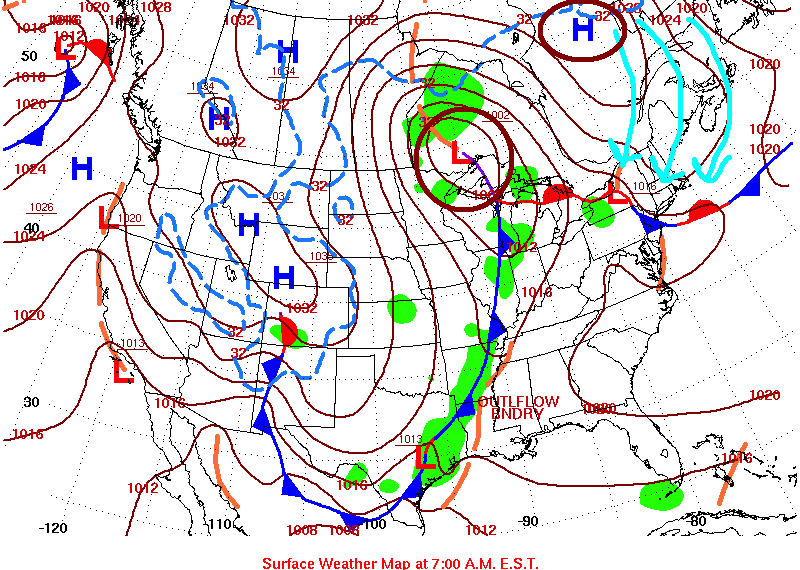
5/13/14 Daily Weather Map
By Tuesday the developing low pressure center has strengthened and moved north. As a result the high pressure center in Canada has strengthened as well and the cold air flowing south has pushed through Southern New England as evidenced by the movement of the frontal boundary from Northern New England to northern New Jersey. With current ocean temperatures in the Gulf of Maine in the upper 40s near 50 it is not surprising that our temperatures barely made it to the lower 50s on Tuesday with an east-northeast wind direction directly off the water.
To end I would like to share the station observation for Monday evening at Logan Airport which is the official observation location for the city. To help with the timeline, at the bottom 20:54 is approximately 5 pm Monday evening. At the top 03:54 is midnight Tuesday. It appears that the cold front passes Logan sometime between 7 and 8 pm Monday night. The temperature dropped 19 degrees from 74 to 55 between the hourly observations and more importantly the wind (3rd column from the left) changed from west at 9 knots to northeast at 28 knots with gusts to 38 knots. Thus ending the three day stretch of wonderful weather with highs in the 80s.

KBOS Observations
Be on the lookout the next time we have a stretch of real warm days, there is a change that the stretch might just be ended by a backdoor cold front.
-Chris
