Now that the Blizzard has passed and the Cape has made it out ok we can turn our sights towards Spring. But before we get there we have some unsettled weather to get through. I am going to show you two images from two of our computer guidance models. Each image represents that piece of guidance’s depiction for total precipitation between 8 pm last night and 8 am Tuesday morning.
The first image is from the European model and paints a picture where pretty much all of New England recieves a couple inches of precipitation between now and Tuesday morning. Southern New England and the Maine coast receive closer to three inches of precip.
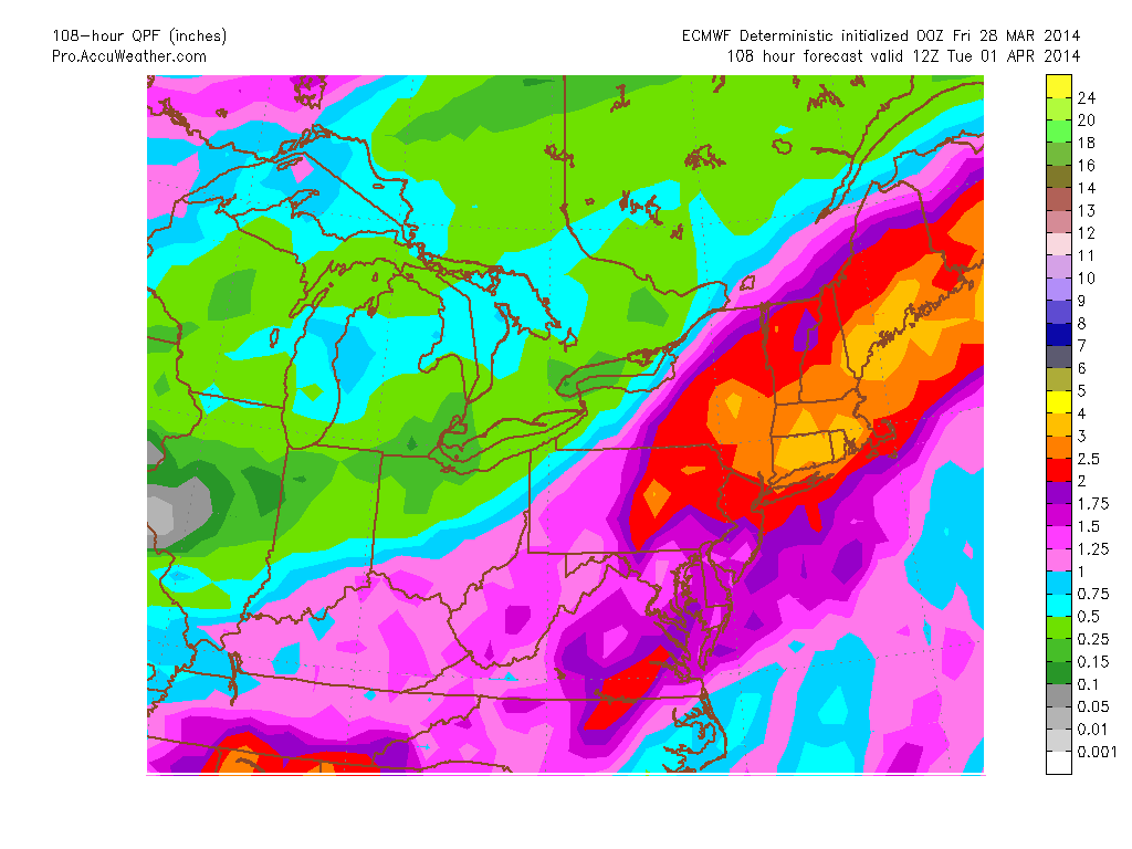
ECMWF Total QPF through 12z Tuesday
The second image is from the American GFS model for the same timeframe. It too is basically giving all of New England at least a couple inches of precipitation. This time with Western New England receiving upwards of three inches of precip.
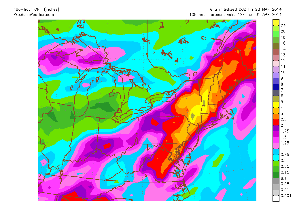
GFS Total QPF through 12z Tuesday
Either way that you look at it a lot of water is about to fall on our heads. All of this being caused by an extremely slow moving storm system pushing off the East Coast. Below is the current infrared satellite image. The colors represent cloud top temperature. The bluer the shade, the taller the cloud. The taller the cloud, the more significant the storm is.
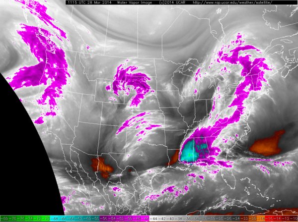
Current IR Satellite Image
This afternoon will feature the occasional rain shower/downpour associated with the batch of purple shading to our west in the image above.
During the day on Saturday is quiet. Highs during the day may well reach to near 60. Late Saturday afternoon/night heavier rain will overspread the region. This rain is associated with the brighter blues that are forming along the Gulf Coast. It will rain heavy through late Sunday afternoon. From Sunday afternoon through say Monday evening there will be times of steadier rain, but it will come in bursts.
When all is said and done by Tuesday night, most of the region will have recieved 2-3″ of rain. Would not be surprising if someone in Southern New England picked up 4-5″ of rain if things work out perfectly over the entire period.
The good news is that this storm system isn’t snow. The air mass in place is just not cold enough. Meaning we can trade in our shovels for umbrellas.
-Chris
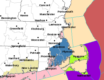
One extremely powerful storm is going to form off the East Coast Tuesday night and Wednesday morning. Fortunately the storm will pass just far enough offshore that the worst of the system will remain out to sea. Below is the current Watches & Warnings map from the Weather Service in Taunton. The light green shading represent Blizzard Watches. The lighter blue represents Winter Storm Watches. The red shading over the ocean represents a Hurricane Wind Warning.

Current Watches & Warnings
The Hurricane wind warning is very warrented. From a meteorological standpoint this system is going to explode off the Mid-Atlantic states. Undergoing such rapid strengthening that bombogenesis (24 millibars in 24 hours) will not be an accurate adjective. There is the potential that the storm will strengthen by 50 millibars in a 24 hours period.
In fact I am quite confident that as the storm passes by to the east of New England that it will likely develop an eye-like feature similar to a hurricane. Even if this feature does not occur, this system will likely produce some extremely epic satellite images. For my satellite sites, follow the links below:
http://wwwghcc.msfc.nasa.gov/GOES/goeseastconusir.html
From a meteorological standpoint it is quite dissappointing that the storm will miss us. It truly would go down in the record books if it were to directly hit us. Mostly for the time of year, but also for its strength. Below is the forecasted 850 mb wind speeds for 2 pm Wednesday afternoon. The European model is advertising an extremly large swath of winds of greater than hurricane strength.
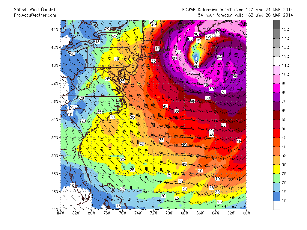
850 mb Wind Speeds
At the same time the surface pressure chart is projected to look like this. The color shadings are precipitation in the previous 6 hours.
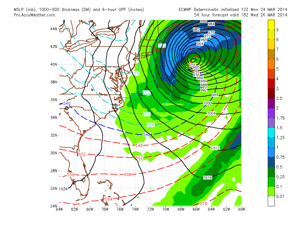
MSLP
Notice how the precipitation shield misses most of Southern New England and just brushes the outer Cape. And this is where the most snow will fall. Below is the forecast map from the Weather Service in Taunton.
Forecast Snow Map
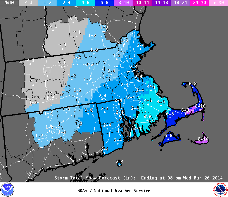
I’m sorry that I am being a bit unoriginal here and just using the forecast from the NWS. While this storm does fascinate me and I am excited to see it unfold, it is my opinion that its impacts outside of the Cape & Islands will be uneventful. Maybe just few higher wind gusts.
It is also my belief that the precipitation shield on the northwest side (us) of the low will feature a very sharp cutoff as the system bombs out. And that accumulation west of the Canal will be kept to a minimum.
Barring an unforeseen jog to the west in the computer guidance over the next 48 hours, we are just going to miss an amazing meteorological phenomena.
GOOD NEWS!!! This storm system will usher in a change in the atmospheric pattern. And Spring might finally begin to arrive with temperatures reaching into the 50s on Friday & Saturday. Yay!!
-Chris
The relatively quiet stretch the we have been enjoying around these parts is going to come to an end Wednesday afternoon/overnight. While not impressive at the moment, the batch of snow showers over Idaho and Montana will go on to form a fairly potent area of low pressure that will pass through Southern New England Wednesday night. Below I have displayed the current U.S. radar to show where our storm is coming from and where it will be going.
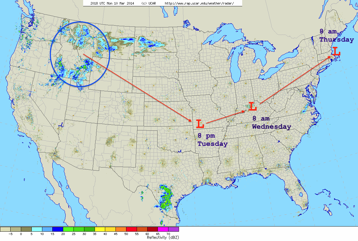
Current U.S. Radar w/Storm Track
This mornings GFS and ECMWF operational & ensemble model runs are in extremly good agreement with regards to the storm track/placement of the surface low pressure center between now and Thursday morning. Because there was such a good agreement between the two it was easy to base the forecast on a blend of the 4 different model solutions.
Timing: Precipitation moves in from west to east across southern and central New England during the late morning hours on Wednesday. Precipitation overspreads all of New England throughout the afternoon and last through the overnight. The heaviest of the precipitation is over by 8 am Thursday morning across SNE, mid-afternoon in NNE as the now fairly strong low pressure center pulls northeast.
Rain/Snow: This is going to be a mainly rain event for all of Southern New England. There is a chance that this may start as a bit of a snow/mix type deal near the Mass border with VT/NH as surface temperatures and temperatures aloft will be flirting with freezing. But either way it will transition over to rain for all of SNE. Right now my best guess on the furthest northward push of the rain/snow line is from Bennington, VT over the Keene, NH, through Manchester, NH over to say York, ME. Places north of the line will likely stay all snow and could see a good bit of it. Places south of this line should expect a good amount of rain that will eventually end as snow as temperatures crash Thursday morning.
Commutes: It appears that this storm will be such that two commutes will be impacted. The Wednesday evening commute will definitely be impacted and depending on where it is you are traveling you will be either faced with heavy rain(south) or heavy snow(north). The Thursday morning commute is a different story. The exact time that precipitation will end is a bit fuzzy at the moment. Right now it appears that the backside of the precip will swing through sometime around 8 am. Meaning that the morning commute will most likely be impacted by the last of the storm and by crews cleaning up.
Snow: As temperatures plummet early Thursday morning most locals will end with a period of snow. The timing for when the transition from rain to snow will occur is crucial to how much snow will fall and is also extremely tricky to nail down. Also difficult to forecast is the position of the rain/snow line. The map below reflects my best guess as to how things will play out. Obviously if things begin to trend away from what I show below then the map will have to change. But for right now this is what I am going to run with.
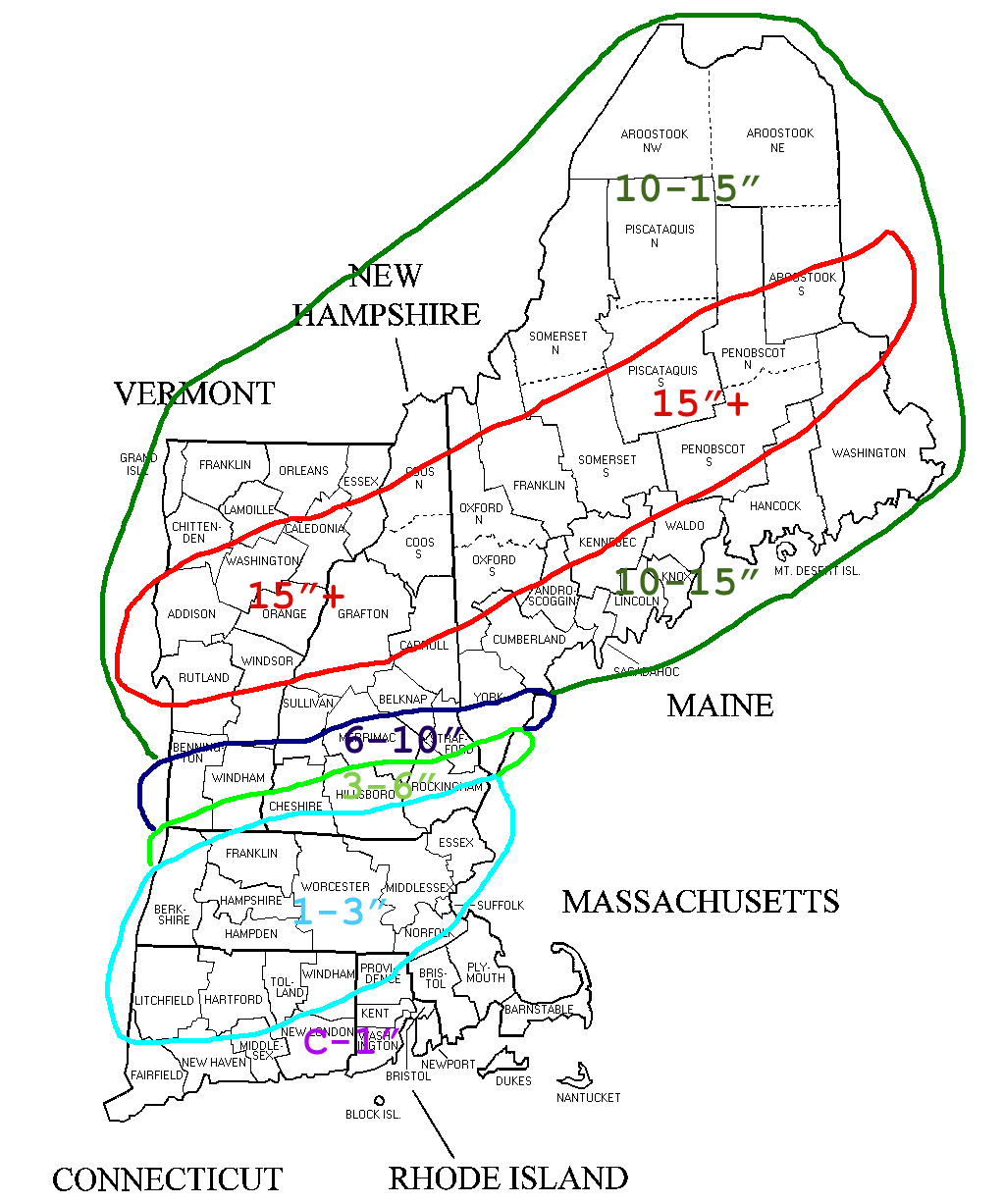
Total Snowfall through Thursday Morning
Thursday: Thursday is not going to be a particularly pleasant day. As the storm continues to strengthen and exits northeast temperatures are going to plummet throughout the day. The days high temperature will most definitely be recorded at midnight. Northwest wind gusts on the order of 35-40 mph combined with temperatures falling through the 20s and into the teens will make for a rather miserable afternoon. With lows Friday morning very likely in the single digits. While Friday will not be the warmest day with highs in the low 30s, Saturday is looking nice with temperatures rebounding to near 50.
-Chris
Winter is never going to end….or at least it feels that way. Besides the random quick couple day warm up we have been experiencing below normal temperatures for the better part of three plus months now. And unfortunately things will continue.
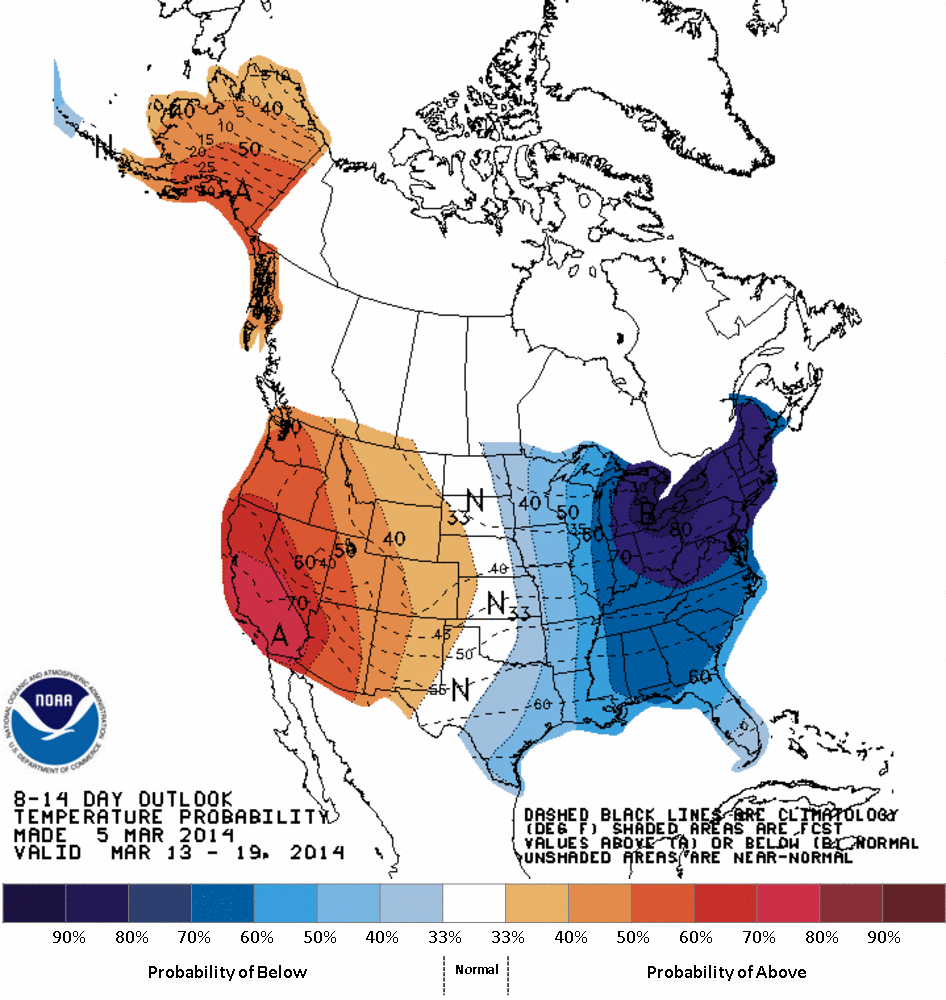
CPC 8-14 Day Temp Outlook
The image above is from the Climate Prediction Center. What this image shows is that we here in New England have a 70% chance of experiencing below normal temperatures for the next two weeks accorsing to the Climate Prediction Center.
The following three images are from the GEFS model guidance courtesy of the wonderful model page developed by the guys at Tropical Tidbits. What each images shows is the 5 day averaged temperature anomaly (how it relates to average).
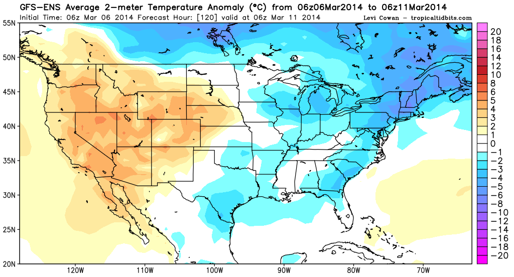
GEFS Temp Anom Days 1-5
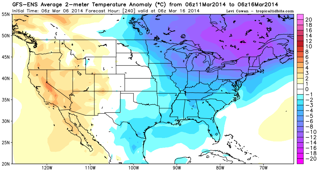
GEFS Temp Anom Day 6-10
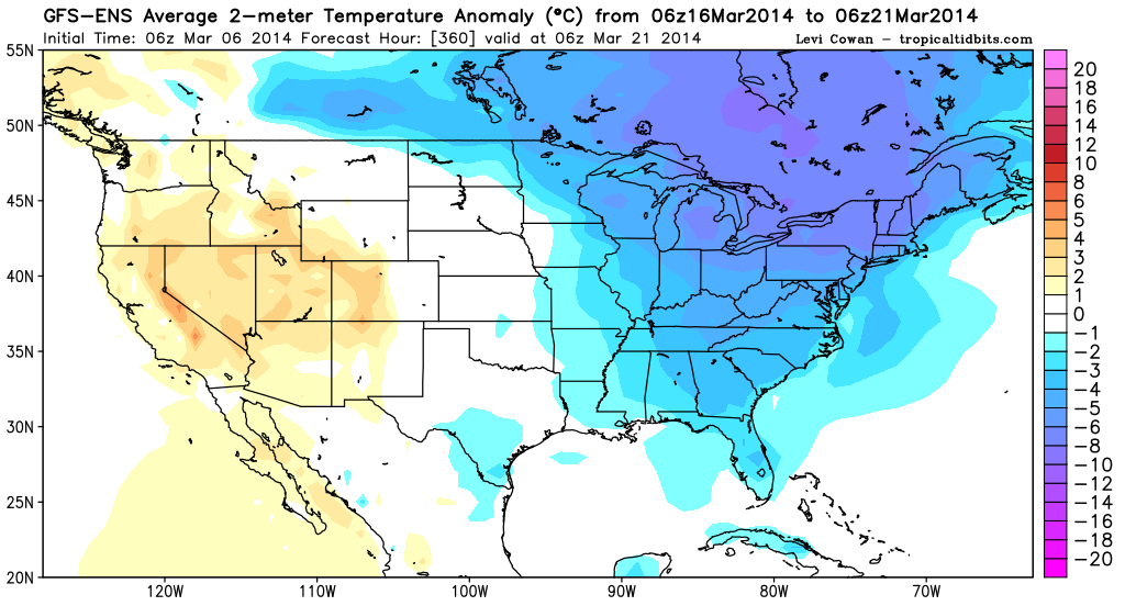
GEFS Temp Anom Day 11-15
As you can see based on the three images above the entire 15 day period is forecast to showcase below normal temperatures. Which after writing this sentence a frown has formed on my face. Typically I root for cold and snow, but at this point I have had it. Meteorological spring began on March 1 and damn it it is time for spring.
As for the other thing that we have had way too much of; snow. Our next real chance of snow isn’t for about a week. And I firmly refuse to answer any and all questions on said potential storm system until it is within 5 days.
There is something to look forward to in the near future. It appears that we may actually see high temperatures in the low 40s again this coming Saturday; followed by a colder Sunday and possibly low 40s again for early next week.
-Chris
