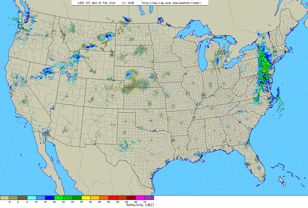
10 am Radar
One last batch of rain/snow is moving through today before we thaw out for a little bit. That batch of showers over eastern Pennsylvania will move through the region this afternoon. Let’s say from about noon through the evening we can expect period of rain and wet snow.
Here is the 10 am temperature map for Southern New England.
Surface Temperatures at 10 am
For all those south of the Mass Pike this should be a mainly rain event. While surface temperatures are cold enough for snow, temperatures aloft are warm enough to support rain. As we progress over the next couple of hours we should see temperatures across Southern New England rise above freezing.
BUT, it would not be surprising if the surface temps stuck below freezing in a few spots. If this does occur then there could be some areas of freezing rain as the rain drops fall into the below freezing air. If this happens then some slick spots can be expected. The most likely locations for the would be northern Connecticut through central Massachusetts along the Connecticut River Valley.
As those north of the Mass Pike they could start as snow. This snow should be very wet and heavy and accumulations should be minimal. A slushy inch or two at most. Temperatures aloft are just too warm.
Here is the latest snowfall forecast from the RAP model for the rest of today.
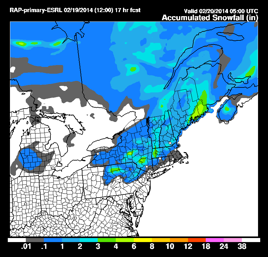
RAP Snow Forecast through 06z
Notice how next to nothing falls in Connecticut or Rhode Island. And even in Massachusetts only an inch or two falls in most places. Except for the Berkshires where the model has 2 or 3 inches falling. This model paints eastern Maine as the jackpot location again for the third storm in a row.
GOOD NEWS!!!
After this batch of precipitation we warm up! A very large and powerful storm will track to our west. And when I say west I mean like west of Chicago west. This puts us on the warm side and will allow warm air to move in from the southwest and allow us to thaw out for a while. Highs should be in the low 40s tomorrow and the upper 40s by Friday & Saturday and finally back to around 40 for Sunday.
Enjoy the warm up while you can as signs point at us going back to the freezer next week.
-Chris
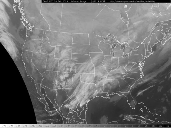
Another round of light snow is on its way for the daytime hours of Tuesday. Current our system is pushing through the midwest and it actually popping thunderstorms over Illinois based on satellite and lightning tracker.
Current Infrared Satellite
This system will continue on a mainly easterly course and pass right along the southcoast before swinging up the coast towards downeast Maine. In doing so it will drop a few inches of snow for most. Higher amounts can be expected from northern Worcester County northeast along the Maine coastline.
The timing on this one is going to be a little tricky. The morning commute should not be a problem in the Boston area as snow may be falling but it will not have accumulated yet.. It is the afternoon and evening commute that is in jeopardy as this is when the heaviest of the snow will come down. Say from roughly 1 pm through 6 or 7 pm will be the heaviest of the snow. Not good for the those trying to get home from work.
As for how much snow is going to fall this event should be more minimal that the last couple. Presently Winter Storm Watches are up for northern portions of Worcester & Middlesex counties in Massachuestts as well as those adjacent counties in southeastern New Hampshire.
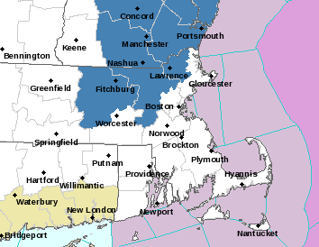
Current Winter Storm Watches
As for how much snow I expect see my map below. Thinking a stripe from Worcester to the eastern tip of Maine will receive the most snow. Somewhere right around 6 inches. With lowering amounts in either direction.
Tuesday 2-18 Snowfall
-Chris
Tomorrow’s storm is literally going to explode off the East Coast. This rapid intensification is called bombogenesis. Yes that is a technical term in the meteorological world. It describes a storm system that strengths by more than 24 mb in 24 hours. Tomorrow’s storm looks to strengthen by 24 mb in roughly 12-15 hours.
Blizzard watches are up for all of Cape Cod & the Islands as well as the rest of the eastern shores of Massachusetts. And I am quite confident that Blizzard conditions will verify for at least the Cape & Islands. Moderately confident they will verify for places along the coast north of the canal.
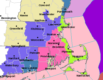
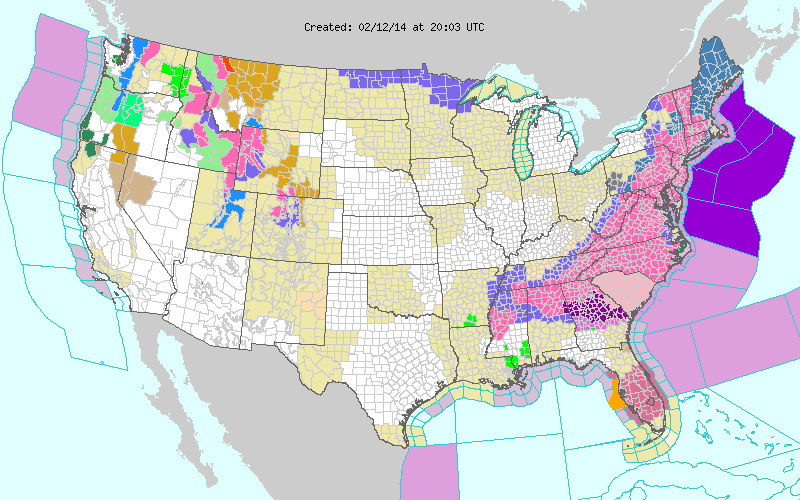
Current Watches & Warnings
The image above is the current watches & warnings for the Taunton National Weather Service forecast area. The green shaded areas represent the Blizzard Watch. Pink shade is Winter Storm Warnings. The light purple color is a Winter Weather Advisory.
As I preciously stated this should be an extremely intense, but quick hitting system. Snow starts flying around 5 pm. And the storm is gone by 5 am Sunday morning. It is those 12 hours in between that are going to be pretty nuts. Basically a winter hurricane is going to pass east of Cape Cod. This should make for some very cool satellite images.
It will also make for some very intense snowfall rates. Especially across Cape Cod. The image below is a simulated radar reflectivity from the NAM model. Anything in the yellow shading is very heavy snowfall, while the red shading is almost unseen snowfall rates. It is shaping up to be a wild night on the Cape.
Simulated Radar Reflectivity 10 pm Saturday
Besides the snow, it is going to be a wild night because of the wind. With such a rapidly strengthening system the winds will be rapidly strengthening as well. Places on the outer Cape will likely gust past hurricane strength at times overnight Saturday. Here is the NAM’s depiction of what the 10 meter wind gusts could potentially be.
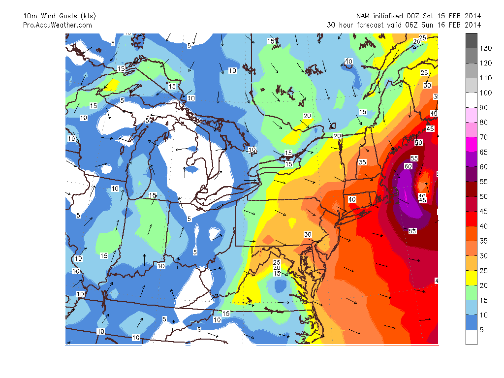
10 m Wind Gusts via AccuPro
Now the value is in knots. Take that value and multiply by 1.15. For example 60 knots = 69 mph. While not hurricane strength, winds just off the deck are sustained at 65 knots or greater. During the times of heaviest precipitation these winds can be dragged to the surface by friction.
As for how much snow we are going to get this is tricky. One fear that I have is that the western edge of the precipitation field is extremely sharp. Meaning that you could go from 18″ of snow in Plymouth County to less than 3″ in eastern Connecticut. But since this is something that is hard to determine before the system has developed my map is based on a more broad precipitation field.
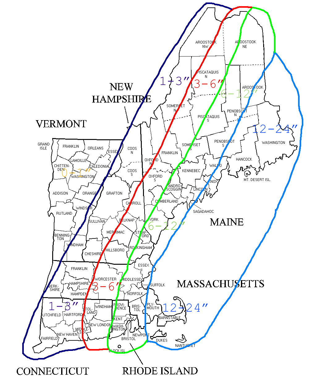
2-15 Snowfall
This is a tricky forecast to nail down how much snow is actually going to fall. If someone in eastern Massachusetts ends up in a band for a significant period of time, then they could end up pushing 2′ of snow. While places 5 miles away only end up with 12″.
But this doesn’t mean that places outside of eastern regions couldn’t end up in a similar band. A rogue band setting up to the west would ruin this forecast and is quite possible. Meaning that someone in the 3-6″ range could end up with double digits. Who knows?
Due to the intense banding nature that is going to happen I have had to leave the snow ranges a bit more broad than usual. I’m just unsure of where these bands will set up. I know that Cape or a part of the Cape will get nailed. But is it the whole Cape or just a half. Does Chatham get 2′ while Sandwich only sees 12″. Only time will tell.
But for right now this is what I have come up with. My fear is that the Cape ends up with 20″+ while anyone west of Worcester gets a few flurries. If this occurs I can say that I have warned you.
Likely one more update in the morning before the first flakes fly.
-Chris
Everyone finished digging out from yesterday’s snow storm? Good. Well let’s get ready to do it again.
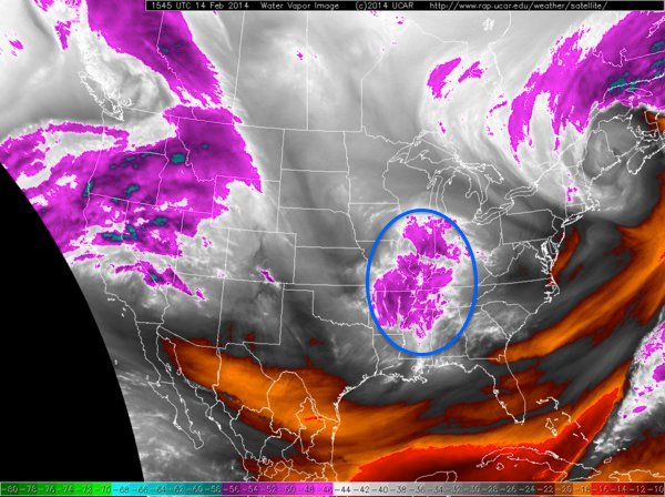
Current Water Vapor Image
This batch of clouds and precipitation over the western Ohio Valley is associated with a potent little piece of energy diving southeast out of Canada. One this piece of energy begins to sniff the Atlantic Ocean off the Carolina coast the surface low pressure center will begin to rapidly intensify. Intensifying from a mid-990 mb storm to a sub-970 mb storm in about 18 hours. Undergoing bombogenesis off the East Coast.
Now the key to this whole forecast is just how close this storm passes to New England. Let me start by saying that on its pass by the storm will be producing blizzard conditions. It is just a matter of if the storm passes close enough to bring those blizzard conditions over us.
The GFS American model has been consistent with its last 3 runs in doing this. While much of the other guidance is just a bit further offshore. However all model guidance throws enough precipitation back in SNE that accumulating snow is going to fall. The big question is just a matter of if the storm passes close enough to produce a quick hitting blizzard.
Unfortunately the true impacts from this storm might not be figured out until they are occurring. We are less than 24 hours from the first flakes flying and the computer guidance has not yet reach a good consensus on what is going to occur.
Right now this is what I am thinking. Kind of put the truth as to what will happen between the GFS and the rest of the guidance.
2-15 Snow Forecast
Remember that if this shift ever so slightly to the west then these numbers go up drastically. If things shift to the east, then the go down slightly.
Will hopefully have another update tomorrow morning with much more confidence.
-Chris
This storm is truly a significant (possibly historic) one. Winter weather watches & warnings are in place from Mississippi to Maine with all places in between. Parts of Georgia & the Carolinas are receiving major snow and ice while central Florida is preparing for severe thunderstorms. Snow is to be expected from Charlotte to Washington to New York City to Boston points north.
Current Watches & Warnings Map
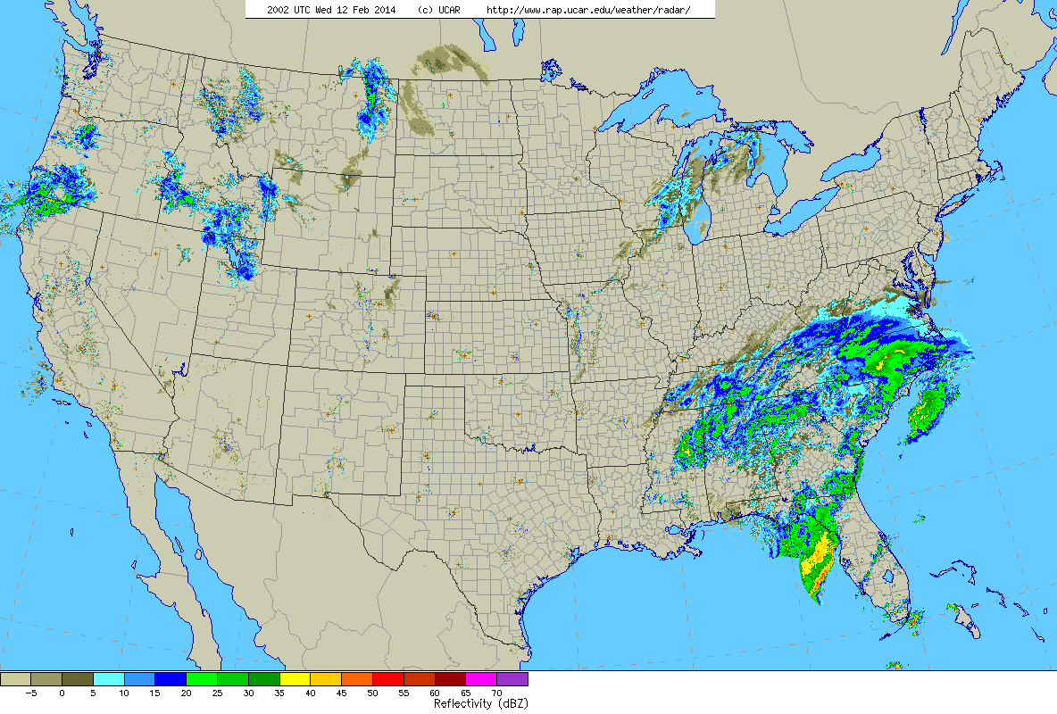
Current U.S. radar
The image above is the current U.S. radar with our storm impacting the southeastern states. Current mesoanalysis has our system as a 1008 mb low pressure center over the northwest Gulf of Mexico. After tracking across northern Florida the storm will then swing up the East Coast. Passing very near to Cape Hatteras, North Carolina. From here the storm should track very near the island of Nantucket and the outer Cape.
With a track like this and origins from the Gulf of Mexico warm air will be an issue. Meaning that there will be the dreaded rain/snow line. The placement of this rain/snow line is the key to the whole forecast and the detail that us meteorologist are agonizing over the most. A shift in this feature of 25 miles or so could be the difference between 4 inches of snow and 14 inches of snow.
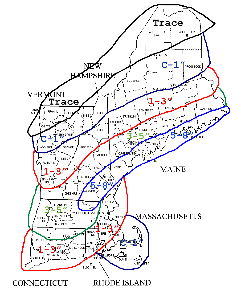
As for what I expect the rain/snow line to do throughout the storm I have created the graphic below in which I have outlined my best guess at the location and orientation of the rain/snow line throughout the event.
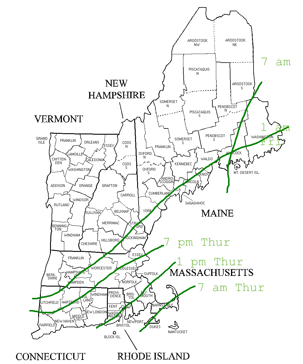
Rain/Snow Line
As you can see from the image above this storm is going to be quite the long duration event; unlike our last one where most got 8-12″ in 8 hours, most will get 8-12″ in 20-24 hours.
Timeline: Snow moves in north to south very early Thursday morning. It could be snowing along the southern shores by as early as 4 am. By 7 am snow has reached the Massachusetts Turnpike. All of Southern New England is snowing steadily by 10 am. By the time we reach early afternoon Central & Northern New England are getting in on the action. Precipitation is heavy through the afternoon and into the early evening.
Now this is where the forecast gets tricky & interesting. There is probably going to be a break in the action where precipitation rates let up and most of Southern New England flips over to a light snow or even drizzle. But as we reach say 10 pm Thursday evening things should pick up again as the primary area of low pressure rapidly intensifies southeast of Mantauk point on the tip of Long Island.
This rapid intesification could lead to a period of very heavy snowfall on the northwest side of the system. It is within this band of snow where our highest totals are found and I believe the placement of this band is outlined in my snow map below. The all ellusive and always impressive phenomena of thundersnow could make an appearance in this band if vertical motion is strong enough.
Snow exits Southern New England by 7 am Friday morning and the main show is over for Northern New England by early afternoon as the storm pulls off into southeastern Canada.
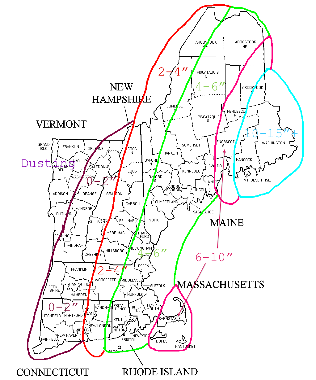
In its wake it will have left a mess. Heavy wet snow, sleet, possibly ice and heavy rain are all in store for Southern New England and the map below represents my best educated guess as to what the snowfall distribution will look like when all is said and done. Unfortunately in uploading my image one of my forecast ranges was chopped off. The range in green along the bottom left is supposed to read 6-10″.

Snowfall forecast
The jackpot amount of 12-18″ represents to my best abilities where I think the band of very heavy snow will set up and move throughout the night Thursday into Friday. A slight shift in this band to the northwest or southeast and the jackpot region will have to be adjusted as such.
Now can you see why this is a tricky forecast? Between the rain/snow line and the location of this potential band this was a tough map to make. It could go wrong in many ways or it could go perfect. Only time will tell.
One other impact I want to mention is the wind. With a rapidly intensifying system this will lead to some very strong wind gusts at times. Wind gusts across the region could possibly be as high as 40-50 mph at times overnight Thursday into Friday. Combined with the heavy wet snow that will be coating the limbs and power lines, power outages can not be ruled out.
But I would like to leave you with a glimmer of hope. The newest 8-14 day temperature outlook paints the East Coast and New England as having a high probability of seeing above average temperatures. Yay!!
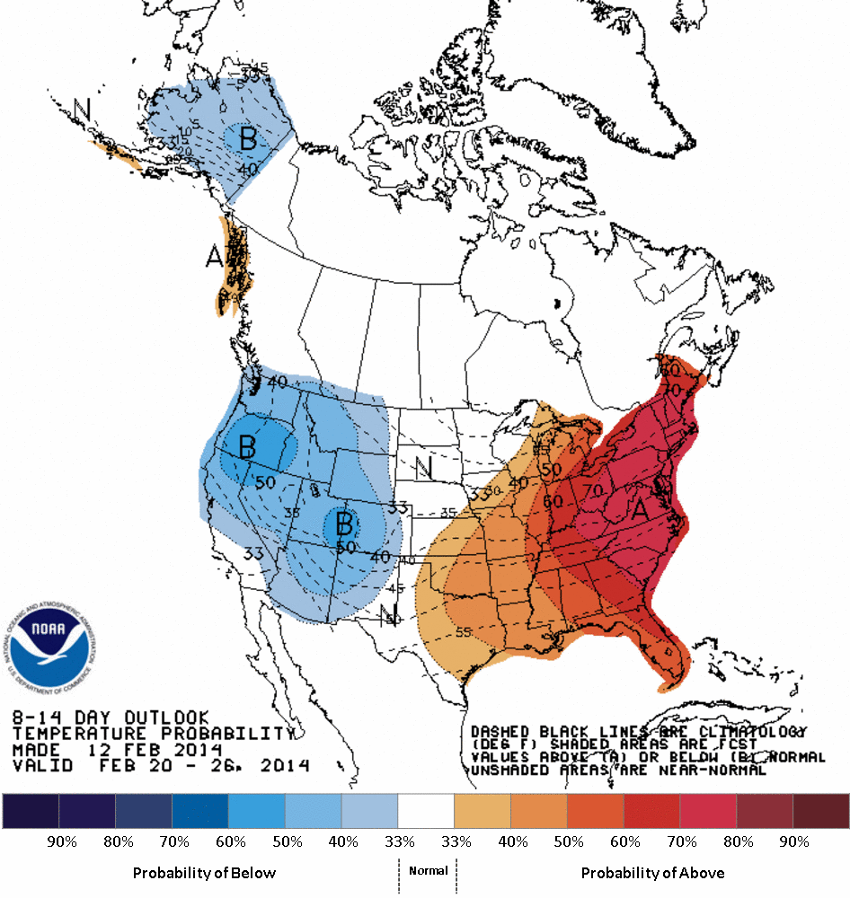
CPC 8-14 Day Temperature Outlook
-Chris
Confidence is growing in a significant storm system traveling north along the Eastern Seaboard bringing a mixed bag of precipitation north with it. This storm looks to produce significant impacts to the major cities along the I-95 corridor. Atlanta, Washington, Baltimore, Philly, NYC, Providence, & Boston could all be looking at significant accumulating snow.
However while there is increased confidence in a significant storm, what is lacking confidence at the moment is the track of the storm. And as always, track is everything; especially here in Southern New England where warm air and mixing could become a problem.
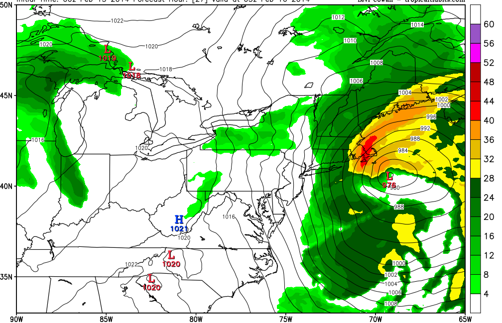
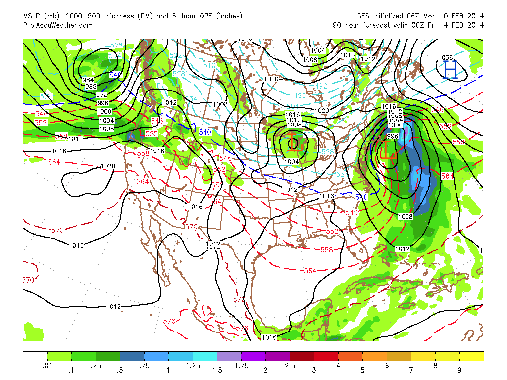
What follows below is a series of images from two of our operational computer models, the GFS (American) and the ECMWF (European). I want to highlight the differences between the two and how the end result differs.
With the current atmospheric set up and the development of our potential storm there are 3 key pieces of atmospheric energy at play. One of which has just entered the Californian coast, the other is just west of British Columbia, Canada and the 3rd is over the northern Pacific. The first two pieces of energy are going to combine over the Southeastern states and form our storm while the 3rd is going to track along the Canada/U.S. border and act as a “blocker” to help determine the path of our system as it moves north along the East Coast.
For the following images the image on top will be from the GFS model and on the bottom will be the ECMWF model. For a larger view of each image, click on the image.
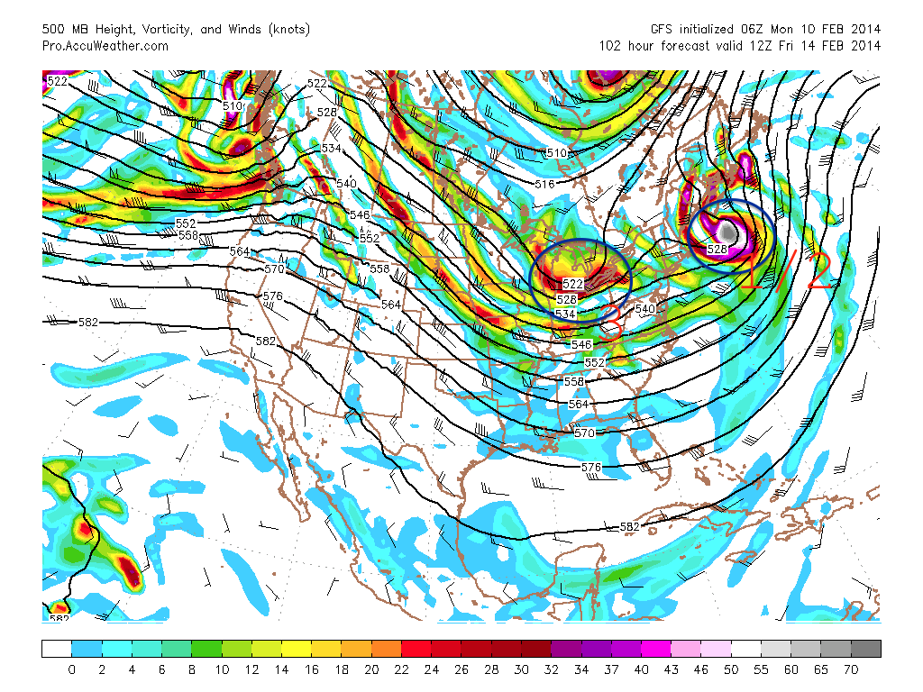
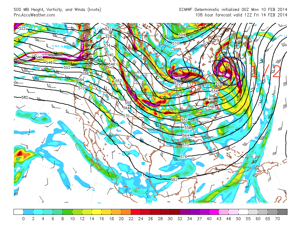
The first two images are 500 mb (17500 ft) vorticity for 7 pm Tuesday night. Remember when we talk vorticity we are talking about energy. In each of the images I have circled and numbered the different areas of interest.
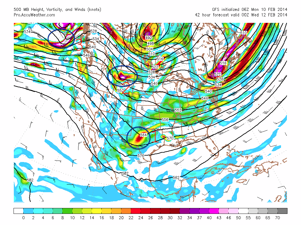
GFS 500 mb 00z Wed
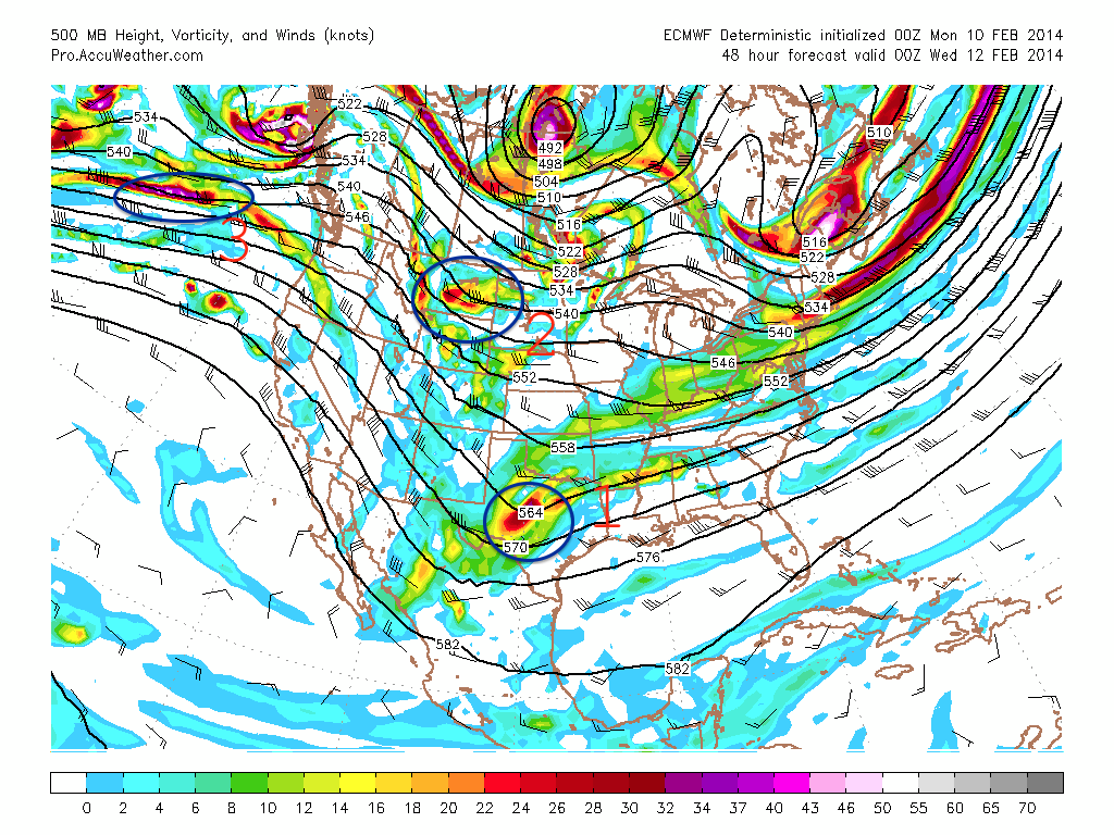
ECMWF 500 mb 00z Wed
Moving forward to 7 am Thursday. Where energy pieces 1 & 2 have phased over the southeast.
GFS 500 mb 12z Thursday
ECMWF 500 mb 12z Thursday
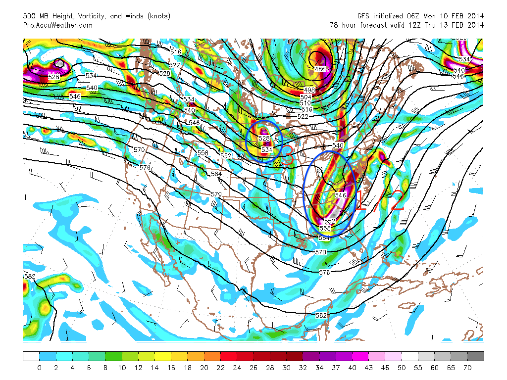
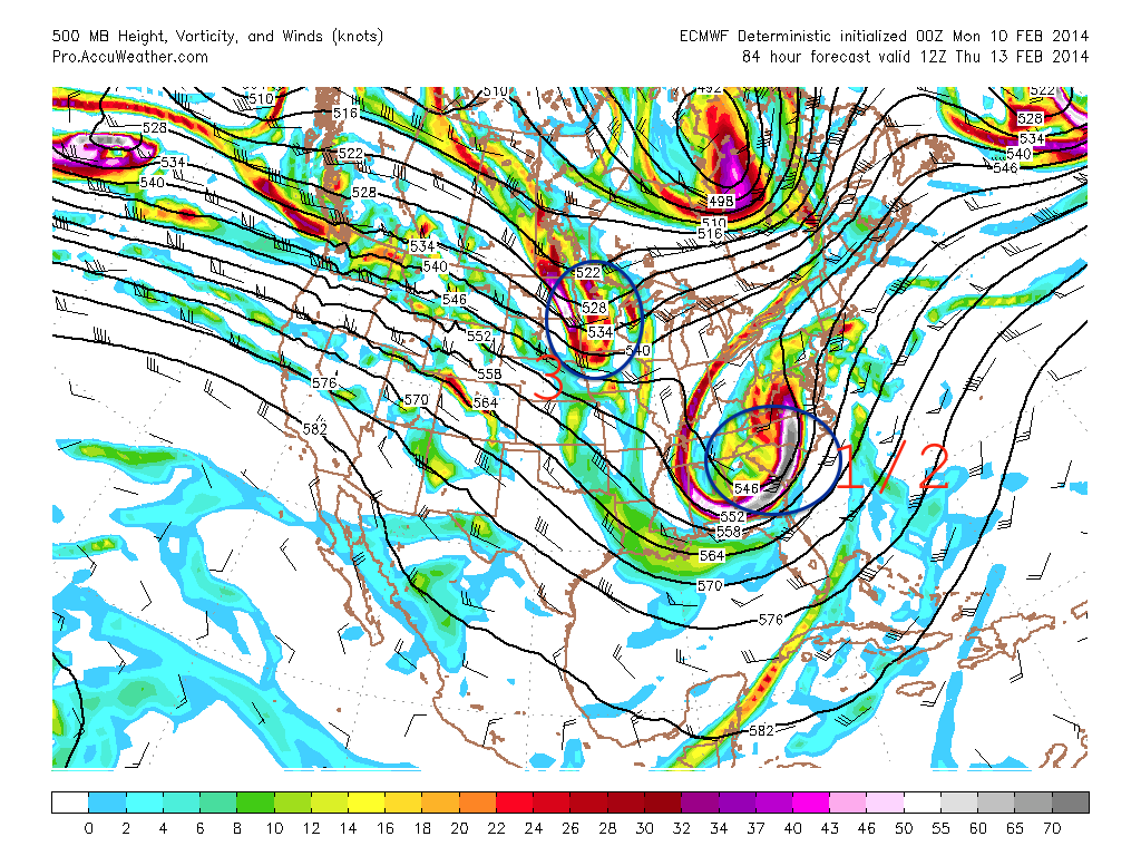
And finally 7 am Friday morning. Where the storm system is passing by New England. Of importance to note is how the ECMWF is further west with the track of the 500 mb energy. As you will see below this causes a further west track of the surface storm center.
GFS 500 mb 12z Friday
ECMWF 500 mb 12z Friday
Now let’s take a look at something that might be a little easier for you to understand. The following images are the surface depiction from the GFS & ECMWF computer models for 7 pm Wednesday night and 7 pm Thursday night. I have marked the maps with L’s and H’s for low and high pressure centers that are at play. The shadings of greens and blues represent total precipitation in the past 6 hours. Light green = less. Blue & light blue = more.
These images are for 7 pm Wednesday night. The storm has developed along the Gulf Coast and is about to traverse across northern Florida and southern Georgia. With origins from the Gulf of Mexico this storm will not be lacking moisture; which could in the end lead to substantial snow totals for those locations that stay all snow on the western side of the storm.
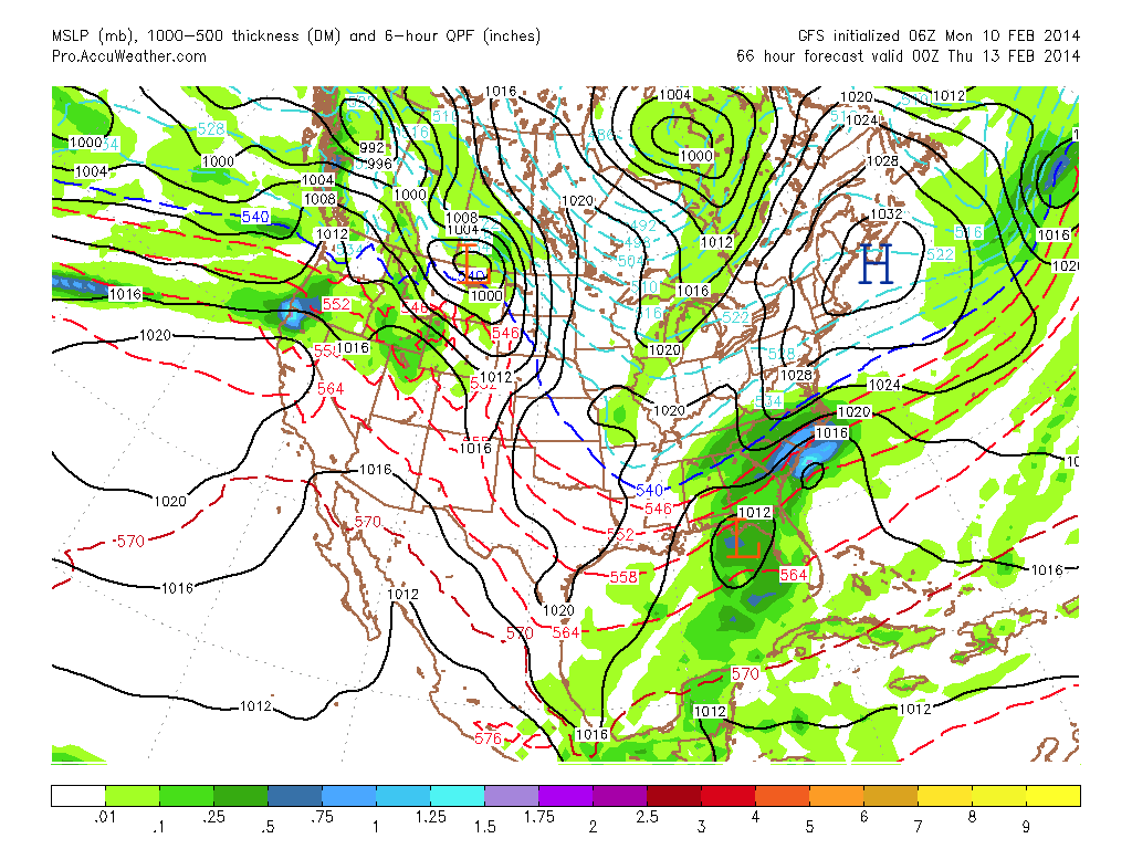
GFS SFC 00z Thursday
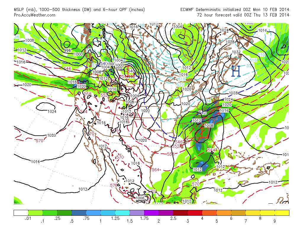
ECMWF SFC 00z Thursday
Moving ahead to 7 pm Thursday evening. High pressure has retreated to the northeast. This will allow warm air to move in across eastern regions of Southern New England in both scenarios. With the track of the ECMWF storm system the warm air pushes even further inland. Making this a very tricky forecast because as always the rain/snow line will play hell with snow totals and drive a forecaster or two bananas.
GFS SFC 00z Friday
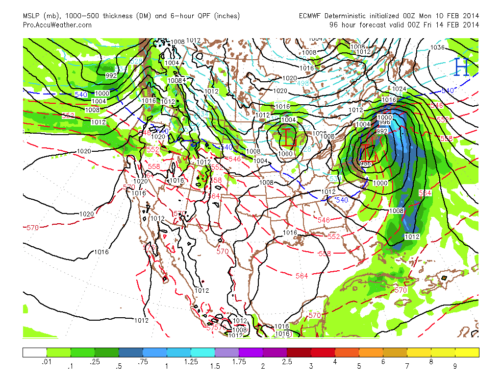
ECMWF SFC 00z Friday
The two images above illustrate how track of the system means everything. The GFS storm center is south of Chatham, MA by 7 pm Thursday evening, while the ECMWF is just east of New York City. The track shown by the ECMWF would lead to mixing and rain making it all the way back to Worcester, MA or possibly further. At the same time if the GFS is correct then the mixing line possibly only makes it back to 495.
We will have to keep a close eye on which direction the models move towards over the coming days. But what the two computer models above lack is wiggle room. So what the meteorological community does is run what we call Ensemble models. We take the same computer model, but change the initial conditions that are put into the model. You do this numerous times and in the end average the solutions together.
Below are three images from three different ensemble mean solutions from the: GFS, ECMWF, and CMC (canadian) for 7 pm Thursday night. In these images I have again marked L’s and H’s for low and high pressures.
GFS
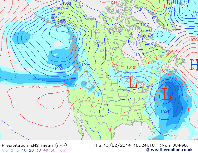
GFS ENS 00z Friday
ECMWF
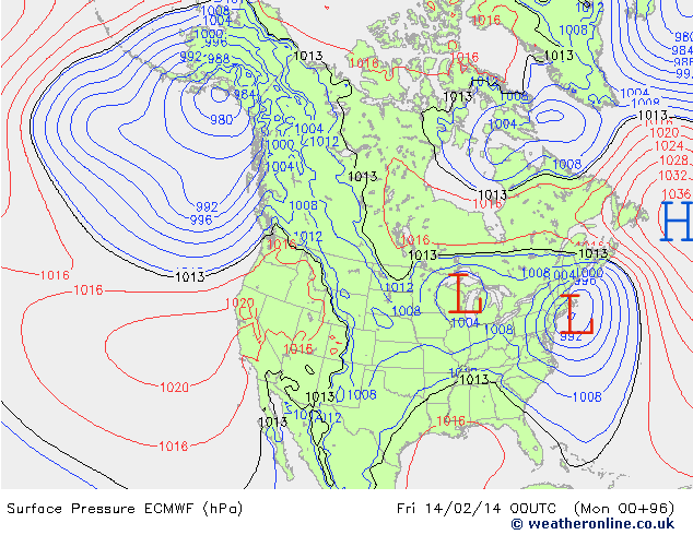
ECMWF ENS 00z Friday
CMC

CMC ENS 00z Friday
Notice how in the 3 images there is a good consensus that a storm system will be somewhere south of Southern New England by 7 pm Thursday. But the three solutions vary with the placement of the low pressure center. The ECMWF is obviously the furthest west, while the CMC is furthest east.
Also note how the placement of the ECMWF Ensemble low pressure center is east of the ECMWF operational low pressure center. This is a bit of a hint that the operational ECMWF is probably too far west and will likely correct east a bit.
Which leaves the GFS ensemble mean which is basically a blend of the CMC and ECMWF all be it a bit slower. For now will consider the GFS Ensemble mean track of the low pressure as a fairly good forecast based off current guidance.
As for the timeline of this event, this looks to be about a 24 hours event from the early morning hours of Thursday through the early morning horus of Friday. Of course the exact start and end time is likely to change slightly and I will keep an eye on it, but the duration of the event I am fairly confident in.
It is too early in the game to put numbers on a map, but what I will do is try to illustrate the precipitation types that different locations could see with the image below.
Possible Precipitation Types for Valentine’s Day Storm
-Chris
After a minor snowfall event today a much more sizeable snowfall is on the way for Wednesday. Energy is gathering across parts of western Texas & Oklahoma. With origins in the southern states this system will not be starved for moisture. And while we do not have the coldest of air masses in place it will be cold enough that a good portion of the precipitation will fall as snow. Especially north of the Massachusetts Turnpike.
12 am Infrared Satellite Image
The image above is the current infrared satellite image at 12 am Tuesday morning. Our storm is the batch of clouds over the Texas/Oklahoma region. This storm system will track northeast toward West Virginia, picking up lots of Gulf moisture on the way. Once the storm center reaches West Virginia it will begin to take a more easterly track and skirt out south of Long Island and the Cape.
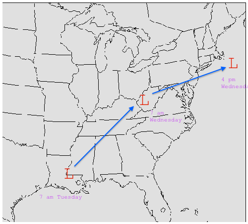
Forecasted Storm Track
With a storm track as the one shown above this will promote an surge of warm air at the mid-levels of the atmosphere. This surge of warm air is crucial to the forecast as those locations that are beneath this layer of warm air will either change over to sleet or plain rain for a period of time. Right now it appears that the surge of warm air will at least reach to the Mass/Connecticut border or even possibly as far north as the Mass Pike.
Those locations that stay all snow are easily looking at 6″+ and likely looking at around 10″. The timeline for this event is mainly during the day on Wednesday. Snow will breakout from southwest to northeast early Wednesday morning with southwestern Connecticut seeing flakes fly by as early as 1 am. It is snowing in Worcester & Hartford by 4 am; all of southern & central New England by 7 am. Snowfall will be heaviest from 7 am to 4 pm and will impact both commutes, especially the morning commute with snow in the air and possibly the evening commute in Boston depending on how long it takes for the snow to taper off.
Steady snow will taper off from west to east during the afternoon. Light snow and flurries could continue through the evening and into the overnight hours, but the vast majority of accumulations will be done by 6 pm.
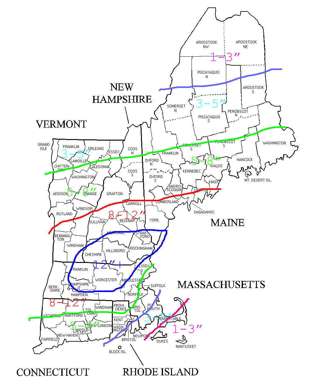
Snowfall Forecast
Right now it appears the jackpot region lies with those locations north & west of route 495 stretching from roughly Springfield northeast into southern Maine. It is these locations that will receive the best combination of cold air and precipitation amounts. Totals drop off to the north due to lower precipitation rates and drop off to the south due to wetter snowfall and eventual mixing with sleet and rain.
So there it is my initial snowfall map for Wednesday’s storm. I’m still keeping a very watchful eye on a potential storm for the second half of the weekend and early next week which is showing early indications that it could be substantially larger than the Wednesday system. But time will tell; one storm at a time.
-Chris
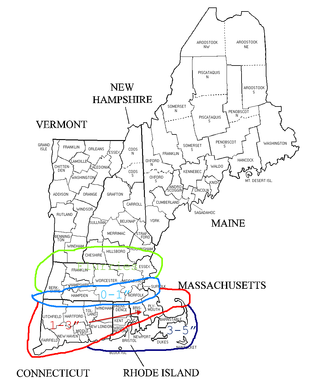
Monday Snowfall Forecast
With the Superbowl being a blowout as it is I have found the time to update you all about tomorrow’s snow forecast. Over the last few computer model runs things have been trending in the direction of the storm possibly passing closer to New England. Therefore I have revised my snow map and upped my totals slightly.
The places that will see the most will be the Cape & Islands where as much as 5″ could fall during the day.
Looking ahead to Wednesday the storm threat is still there and as it stands now a plowable snow event is on the way for many. Be on the lookout for a snow map tomorrow at some point.
-Chris
As we enjoy possibly our best weekend in the last 2 months we look ahead to not one, but possibly two snow chances for the early part of next week. The first of which will be here Monday afternoon. This one does not appear to be of any significance as it will only impact those along the South Coast. Snow accumulation map below.
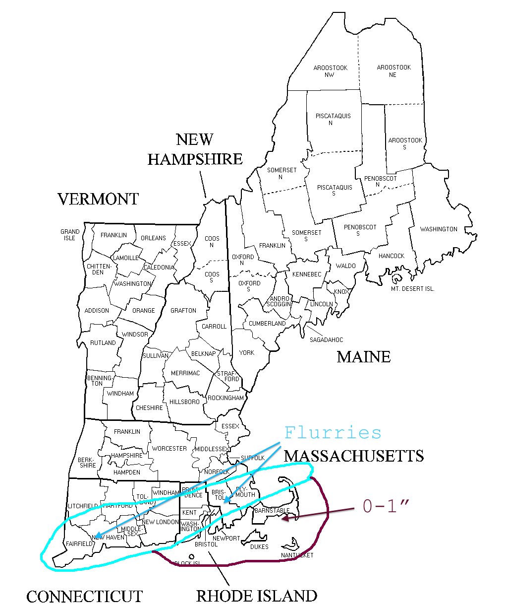
Snow Fall Monday Afternoon
The follow up system during the day on Wednesday will be much more significant and will bring with it a lot more moisture than the Monday storm. As it stands now an original area of low pressure looks to track towards western Pennsylvania before a new low pressure center develops along Long Island. With a storm track such as this there is high probability that a rain/snow line will enter into the forecast, but a fine detail such as this will be determined in the coming days.
We are still a bit too far out to throw numbers on a map, but what I would like to do is show a map that puts the idea out for those locations that could see a plowable amount of snow.
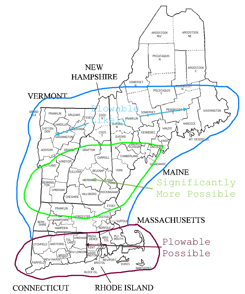
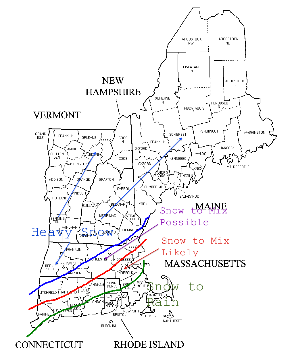
Wednesday Snow Possibilities
Let me try to explain the categories:
Plowable Possible: These locations are most likely to see a flip over to a mix or plain rain. Even though this may occur snow will be the primary precipitation for a long enough time at the beginning of the storm that a plowable amount of snow is still possible.
Plowable Likely: Those that fall in this category will likely stay all snow and see enough precipitation that the plows will be out taking care of the roads.
Significantly More Possible: Regions that best combine the likelihood of staying all snow and receiving a lot of it. 8″+ is not out of the question.
Then after Wednesday we have another storm chance for the weekend/early next week. And even though this is still 7+ days away this one has the possibility to be the most significant of the three. But time will tell.
Stay tuned in the next couple days for a snow fall map for Wednesday.
-Chris
