Absolutely lovely weather conditions we have right now huh? Cold drizzle. Just the worst. I mean if it is going to be this cold, then it might as well snow right? Luckily things are warming up. Highs look to be in the 60s tomorrow through Saturday.
Conditions for tonight’s Red Sox game look to be ok. Little to no wind, no rain, but cool. Temps in the upper 40s by game time. IF there is a game 7, conditions should still be ok, just a bit warmer.
Friday’s forecast looks a bit interesting. A strong low pressure center will track to our west through the Great Lakes and into Canada. This storm will be quite strong. At the same time a strong area of high pressure over the northern Atlantic will strengthen as well. As a little rule of thumb, the difference in pressures between the high and low is a rough estimate of the wind gusts one could see. As currently modeled the strength of the low is 980 mb. While the high is modeled to be 1028 mb. That is a difference of 48 mb. Meaning would could estimate gusts of 48 kts. Or roughly a little over 50 mph. Which is quite strong.
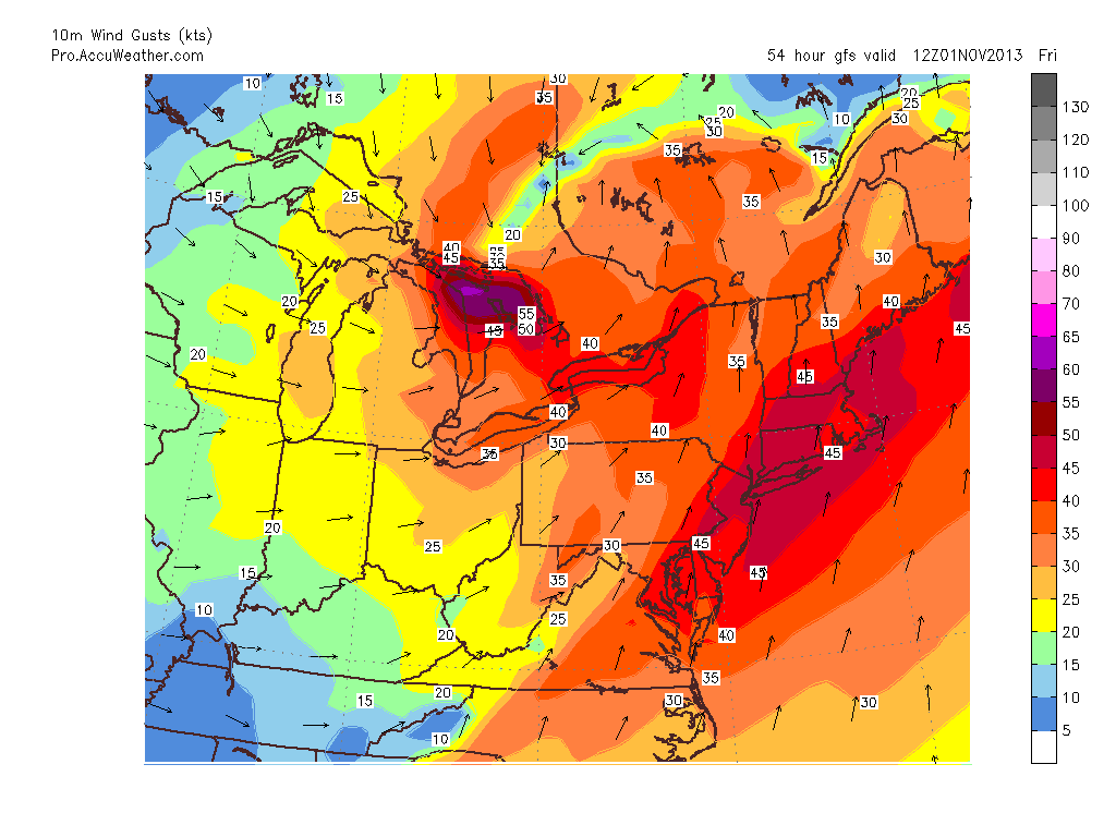
10m Wind Gusts
Above is the GFS model solution for the 10 meter wind gusts across the Northeast for Friday morning. It is advertising the chance for wind gusts to be on the order of 45 knots; or 51.75 mph. The GFS is not alone in this solution. The European model agrees with this solution. While 10 meters is not the surface, it is only 33 feet off the ground. And there are plenty of trees at 33 feet up.
Meaning that Friday morning will feature rain at times with very gusty winds. Downed limbs, power lines and trees can not be ruled out.
While the wind and rain is the dreary side of the forecast, the good thing about the storm tracking to our northwest is that it will usher in warme air. Highs Thursday through Saturday will be in the 60s. A nice change from the temperatures we have been experiencing.
Heading into next week temps will fall back after a cold front moves through Saturday night. Highs early next week will fall back into mid 40s to near 50.
7 DAY FORECAST
Wednesday: Cold morning drizzle exiting by early afternoon. Highs 50-55.
Thursday: Mostly cloudy with rain moving in very late evening. Highs around 60.
Friday: Rain at times with very gusty winds. Gusts 45-55 mph are possible. Rain exits late afternoon. Highs near 65.
Saturday: Partly cloudy with highs near 65. Remember to put clocks back overnight.
Sunday: Partly cloudy with highs in the low 50s.
Monday: Cold. Highs only 40-45.
Tuesday: Partly cloudy with highs 45-50.
-Chris
