Absolutely lovely weather conditions we have right now huh? Cold drizzle. Just the worst. I mean if it is going to be this cold, then it might as well snow right? Luckily things are warming up. Highs look to be in the 60s tomorrow through Saturday.
Conditions for tonight’s Red Sox game look to be ok. Little to no wind, no rain, but cool. Temps in the upper 40s by game time. IF there is a game 7, conditions should still be ok, just a bit warmer.
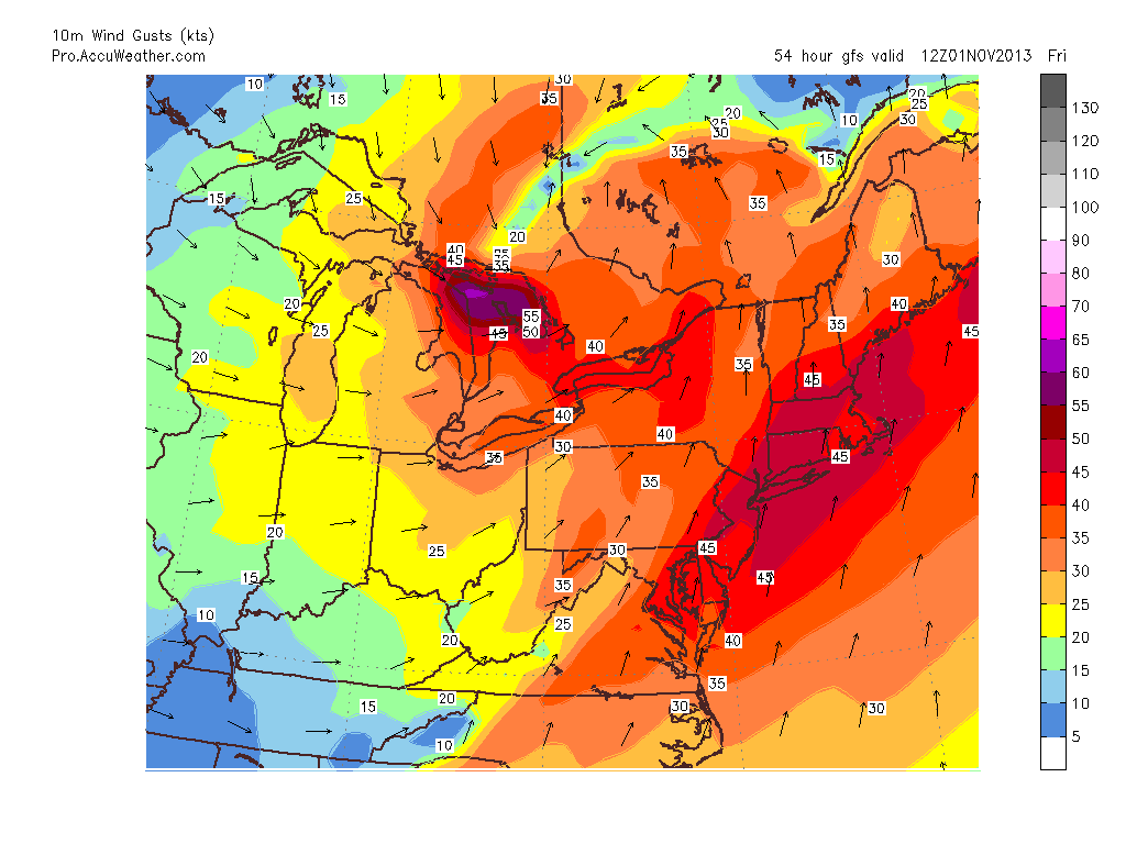
Friday’s forecast looks a bit interesting. A strong low pressure center will track to our west through the Great Lakes and into Canada. This storm will be quite strong. At the same time a strong area of high pressure over the northern Atlantic will strengthen as well. As a little rule of thumb, the difference in pressures between the high and low is a rough estimate of the wind gusts one could see. As currently modeled the strength of the low is 980 mb. While the high is modeled to be 1028 mb. That is a difference of 48 mb. Meaning would could estimate gusts of 48 kts. Or roughly a little over 50 mph. Which is quite strong.
10m Wind Gusts
Above is the GFS model solution for the 10 meter wind gusts across the Northeast for Friday morning. It is advertising the chance for wind gusts to be on the order of 45 knots; or 51.75 mph. The GFS is not alone in this solution. The European model agrees with this solution. While 10 meters is not the surface, it is only 33 feet off the ground. And there are plenty of trees at 33 feet up.
Meaning that Friday morning will feature rain at times with very gusty winds. Downed limbs, power lines and trees can not be ruled out.
While the wind and rain is the dreary side of the forecast, the good thing about the storm tracking to our northwest is that it will usher in warme air. Highs Thursday through Saturday will be in the 60s. A nice change from the temperatures we have been experiencing.
Heading into next week temps will fall back after a cold front moves through Saturday night. Highs early next week will fall back into mid 40s to near 50.
7 DAY FORECAST
Wednesday: Cold morning drizzle exiting by early afternoon. Highs 50-55.
Thursday: Mostly cloudy with rain moving in very late evening. Highs around 60.
Friday: Rain at times with very gusty winds. Gusts 45-55 mph are possible. Rain exits late afternoon. Highs near 65.
Saturday: Partly cloudy with highs near 65. Remember to put clocks back overnight.
Sunday: Partly cloudy with highs in the low 50s.
Monday: Cold. Highs only 40-45.
Tuesday: Partly cloudy with highs 45-50.
-Chris
The month of October is a transition month where days at the beach are being put into the back of our minds and suddenly the thoughts of shoveling snow are beginning to enter the forefront of our thoughts. As nature transitions from the green colors of life to the reds and oranges of decay so to does our weather transition from the warmth of summer to the cold of winter. October is a month stuck in the middle with shorter days and decreasing odds of leaving the house without a jacket or sweatshirt. And while this may be a doom and gloom outlook with cold weather and winter on the horizon, this helps to bring a smile to my face.
As the month of November nears so to does our first snowfall. Almost like counting down the days until Christmas many of us weather lovers here in New England count down the days until the first flakes are flying. And going forward it looks like those first flakes will be flying sooner rather than later for most. In fact, if things fall the right way then elevated places across the interior of Southern New England might see their first flakes Wednesday night.
In fact the next 15 days look to be slightly below normal temperature wise. This time of the year our daily high temperatures average in the upper 50s. The 7 day forecast below calls for temperatures to be slightly below normal all days except for tomorrow. The following three images are averaged temperature anomalies from the GFS computer model for the three time periods of days 1-5, 6-10, and 11-15.
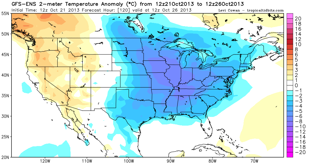
Temperature anomaly for days 1-5
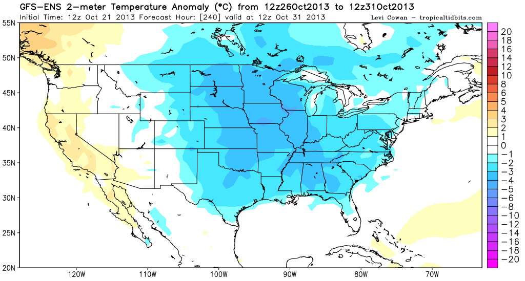
Tempeture anomaly for days 6-10
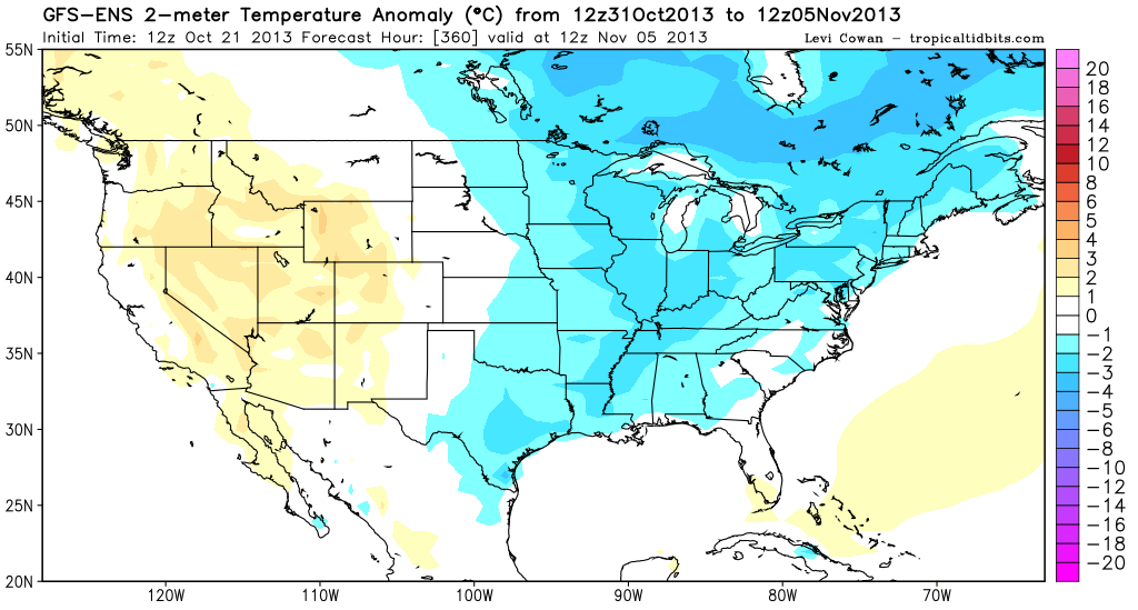
Temperature anomaly for days 11-15.
You can see from the images above that the eastern half of the United States looks to be below normal for the three periods above. This is due to the longwave pattern that has established itself over the North American Continent. This pattern is characterized by a large ridge in the west and a large trough in the east. Think large high pressure out west and generally low pressure in the east. What this pattern does is it allows for air from northwestern Canada to invade the eastern half of the country. Putting that half below normal for temperature.
Fortunately it does not appear that there will be many chances of precipitation during this period of colder weather. Which is good because although the temperatures are below normal, they are not exactly cold enough for sustained snow fall. Meaning that if we were to get a storm it would likely be a cold, raw rain event. Which no one ever likes.
Although I am not the biggest fan of making seasonal forecasts as it is my opinion that making the forecast for three days from now is tough enough, why try making a forecast for three months from now. But if I were to take a stab at this winters forecast, the early hints are showing a below normal winter temperature wise with possibly an above average winter precipitation wise. Which is great for me as I am a big fan of cold and snow.
But back to the short term. A cold front looks to push through the region Tuesday afternoon bringing showers to Northern New England. Wednesday afternoon a wave of low pressure should form along this cold front and track off the East Coast. Depending on how close this low pressure center passes to Southern New England will determine if locals will experience rain fall Wednesday evening. As it stands right now it looks like places east of Worcester have the highest probability of seeing some rain Wednesday evening. After that our chances for rain look slim, but temperatures will be cool with highs in the low 50s.
7 Day Forecast
Tuesday: Showers likely in Northern New England with highs in the mid to upper 60s.
Wednesday: Storm passes south of Southern New England. Chance of rain increases the further south and east one lives. Highs around 55.
Thursday: Mostly sunny with highs around 50.
Friday: Partly cloudy with highs near 50.
Saturday: Partly cloudy with highs near 50.
Sunday: Partly cloudy with highs around 55.
Monday: Partly cloudy with highs 50-55.
-Chris
