My apologies for not posting for over 2 months now. Summer time is not the easiest time of the year for myself as I spend most of my time working and away from the world of weather counting down the days until school begins again. Alas another school year is upon us and it is time that I update this blog and fill you in on the world of weather.
Another reason for my lack of writing has been the fact that the weather department as been extremely boring!! It is quite difficult to get motivated and type up a blog about how the next 7 days look average with the small chance of a shower at random times.
But this lack of interesting weather is not only confined to our corner of the country. The weather just about everywhere else is rather sleepy. I mean did you know that we set a new record low for number of tornadoes in a rolling 12 month period last month?
Maybe you didn’t know that little tidbit about the lack of tornadoes, but you must have noticed how quiet the tropical Atlantic has been this season. Even with the predictions of an above average year and many a Hurricane; the Atlantic Hurricane season has been a snoozer. We are a bit ahead of schedule when it comes to named Tropical Systems, but not a one has been impressive or a real threat to the U.S. mainland.
Maybe, just maybe Mother Nature will throw us a bone and things will become interesting again in time for Winter.
But let’s take a look at what is going on:
SUMMER
Summer here in New England has been a bit of a roller coaster ride. We started with the month of June that featured rain and more rain. The following two images show you exactly how much rain fell in June and just how much above average that amount of rain is.
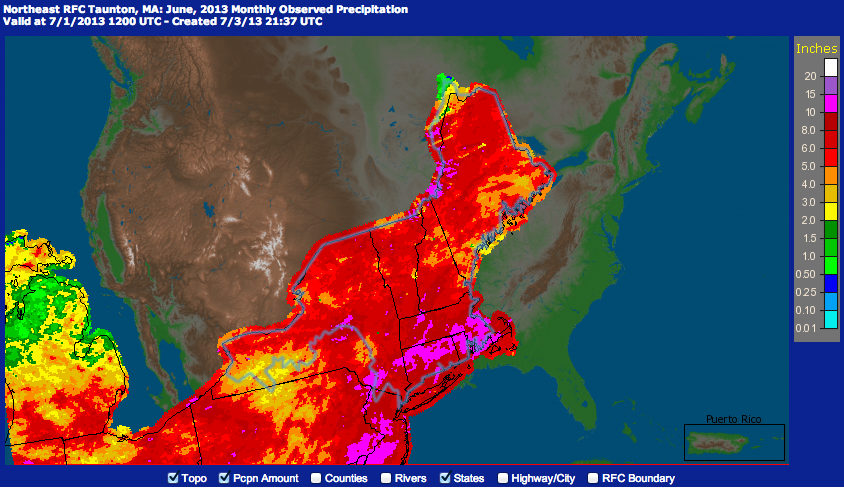
June Total Rainfall
Just to prove how much rain we got here is our departure from normal for June. Showing that most of Southern New England received 3-5″+ in excess of rainfall.
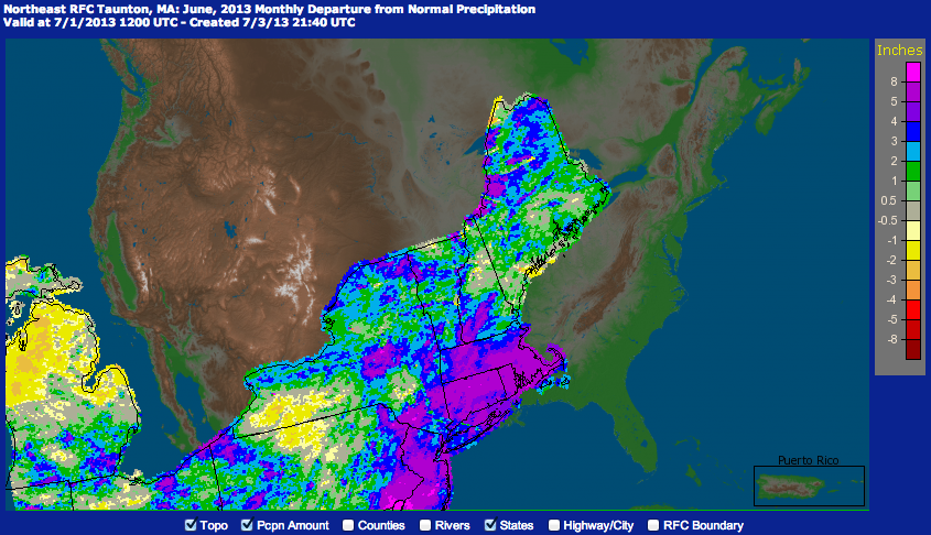
Departure from Normal for June
A lot of water in the month of June transitioned into a lot of heat for the month of July. July was hot around here. Boston recorded 12 days with high temperatures above the 90 degree mark. This included both a 5 day heat wave and a 7 day heat wave. This 7 day heat wave was one day short of tying Boston’s record of 8 straight days above 90. The following image shows that our corner of the country was warm for the month of July. Anywhere between 2 and 4 degrees above average.
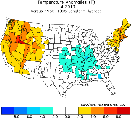
Departure from Average Temperature for July 2013
The month of August however was truly a snooze fest. Unless you get excited by highs in the lower 80s and sunny skies. Yes this does make for wonderful weather to enjoy outdoor activities, it does not however make for interesting blog topics. August was so vanilla that Boston did not record a single day with a high temperature at 90 or above. We would have to wait until the early parts of September for our next 90 degree day.
TROPICS
First let me start with a couple of the seaonal forecasts for the Atlantic Basin. The National Hurricane Center believed that 13-19 named storms would form. With 6-9 of those becoming hurricanes and 3-5 of them becoming major hurricanes.
Along the National Hurricane Center, the other “reliable” source of seasonal forecast for the Tropical Atlantic is Colorado State and the Tropical Meteorology Project. Their season forecast included 18 names storms, 9 hurricanes and 4 major hurricanes.
As of this posting the Atlantic Hurricane season looks as follows:
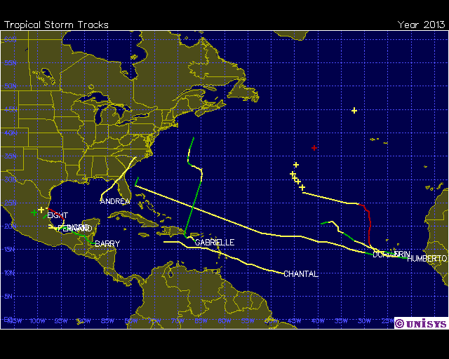
2013 Hurricane Season as of September 16th
As far as named systems are concerned (storms reaching Tropical Storm strength) we are doing just fine considering we have just recently reached the half way point of the season. But when you consider that our first hurricane (Humberto) formed just 5 days ago and more than a month after the date of the average first hurricane; it has been a really quiet year in the Atlantic.
The major culprit behind the lack of activity has been what is known as the Saharan Air Layer (SAL). This year in particular the SAL has been more than prominent in the main development region of the tropical Atlantic. The SAL is exactly what is sounds like. It is a layer of atmosphere that orignates over the Saharan Desert in northern Africa that is represented by very warm temperatures and a lack of moisture. This layer of atmosphere helps to squash convection as it tries to form. The image below is the current state of the SAL represented by the red and yellow pixels in the image.
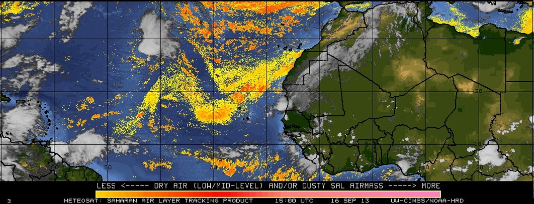
The image shows that the majority of the MDR, main development region is covered with a layer of hot, dry air that has originated from the Saharan Desert in Africa.
Going forward it appears that the Atlantic will stay quiet as guidance does not point to much development in the coming days. May have to monitor something trying to develop off East Coast, but looks to stay away.
FORECAST
Monday: Mostly cloudy as cold front moves through. An isolated pop up shower is possible. Highs near 65. Northwest wind 0-5 mph.
Tuesday: Mostly clear with highs ranging 60-65. North wind 0-5 mph.
Wednesday: Clear with highs around 70. Winds light & variable.
Thursday: Clear with highs 70-75. West wind 0-5 mph.
Friday: Partly cloudy with highs in the upper 70s.
Saturday: Increasing clouds ahead of a cold front moving in from the west. Highs 70-75 with increasing chances of rain during the afternoon & evening hours.
Sunday: Cold front pushes through and rain/clouds begin to depart during the morning. Highs around 70.
-Chris
