After the what seemed like weeks of endless rain and cool temperatures; we have finally turned the calendar into summer and the weather is slowly responding. With each passing day we have slowly been building heat and humidity. Which means that our chances of thunderstorms have slowly been increasing as well.
Today is the first day with a real chance of a thunderstorm. With forecasted high temperatures in the mid-80s and dew points in the mid-60s; this gives way to an environment favorable for vertical motion. All that is needed is something to force the air along the ground skyward. What we need is a forcing mechanism that will cause the air to rise. And when air rises, it gives way to clouds and in the right environment; thunderstorms.
We have the environment for vertical motion in place (and for the next few days), all that we need is a forcing mechanism. Today we do not seem to really have a forcing mechanism, but if we can get a few isolated storms to form, they will have an environment to grow and become sustained.
The chance for thunderstorms continues through at least Tuesday. It does appear that the bulk of the thunderstorm actvity will be located across central/northern New England; but a few storms in southern New England are definitely a possibility.
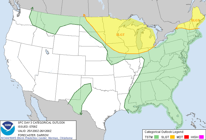
The Storm Prediction Center in Norman, Oklahoma has highlighted northern New England with a “Slight” Risk for severe thunderstorms for Tuesday. SPC notes that the environment will be favorable for rotating storms; but the main threat will likely be severe winds and hail.
Unfortunately toward the end of the forecast a return to cooler and wettter weather looks likely. A storm system looks to drop out of northwestern Canada and set up shop over the East Coast. But this is toward the end of the forecast and beyond and changes will likely need to be made.
7 DAY FORECAST
Sunday: Partly cloudy with highs in the upper 80s. Chance of an afternoon thunderstorm. Southwest wind 5-10 mph.
Monday: Partly cloudy with highs in the upper 80s. Humid!! Chance of an afternoon storm. West wind 5-10 mph.
Tuesday: Partly cloudy with highs in the upper 80s. Chance of a storm; especially in northern New England. Southwest wind 10-15 mph.
Wednesday: Partly cloudy with highs near 85. Slight chance of a shower or storm. Southwest wind 5-10 mph.
Thursday: Mostly cloudy with highs near 70. Chance of rain increasing throughout the day.
Friday: Mostly cloudy with rain. Highs in the 60s.
Saturday: Partly cloudy with highs in the mid 70s.
-Chris
