A lot of talk has been made in the last couple of days about the long range pattern ahead through at least the 4th of July. Well now it is my turn to chime in. And I have to say that I agree with the outlook. It does appear that for the forseeable future there will not be a day where the chance of thunderstorms will not be in the forecast.
But why?
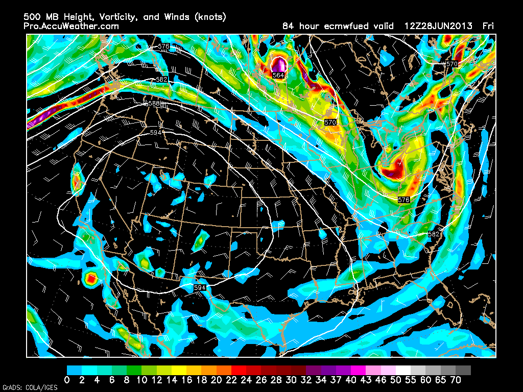
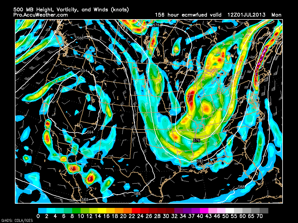
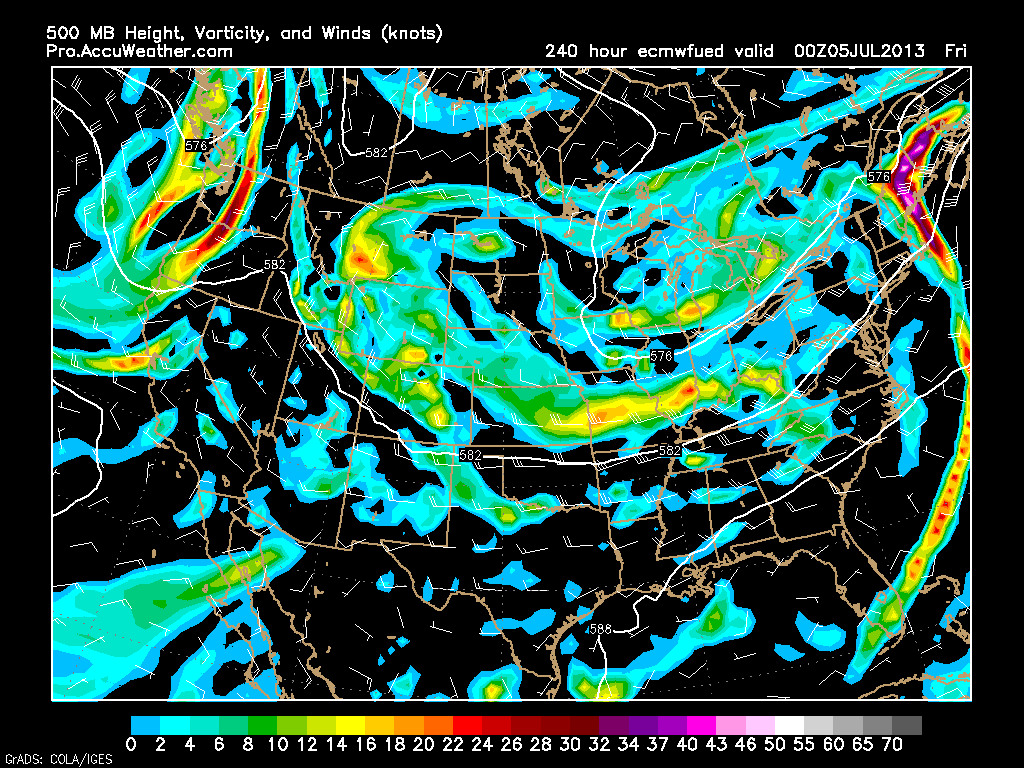
An anamolous highly amplified long-wave trough is going to move into a position just to the west of the East Coast along or maybe just west of the Appalachian Trail. What is amazing about this trough is that it is going to stay in this position for at least and if not more than a week.
Here is the European Model’s depiction of the trough from Friday morning.
European Model’s depiction of the trough on Monday morning; July 1st.
And finally at the end of the model’s run, here is the trough for Thursday evening; July 4th.
But what does all this mean?
What we are talking about is a trough. A trough in the upper atmosphere is a region with generally low atmospheric pressure. Well low pressure is a recipe for disturbed weather; i.e. rain and storms.
But what is also important is the position of the trough. With the axis (center) of the trough positioned to our west along and possibly just west of the Appalachian Mountains, this will allow for the trough to dip into the Gulf of Mexico and stream warm/moist air northward along the Eastern Seaboard.
Let us do a little math. Low pressure with warm/moist air is the recipe for many afternoons with scattered showers and thunderstorms.
Some afternoons will likely feature more widespread and sometimes severe thunderstorms as pieces of atmospheric energy rotate around the base of the trough and make their way up the East Coast.
But all is not bad. Temperatures will be much better than what we are currently experiencing. We can say goodbye to these temperatures in the low to mid 90s and hello to temperatures in the 70s to low 80s.
So looking ahead we can expect more comfortable temperatures that come with the chance of showers and storms everyday from now through the 4th of July. Right now it is difficult to determine if any day will be a complete washout, but there is always that chance. Will have to keep a watchful eye on the chances of a washout and the chances of severe weather.
Today’s Forecast
Partly cloudy with highs in the low to mid 90s. Humid! Afternoon showers and storms between 5-8 pm. Some storms may be severe. So just keep a watchful eye on the sky.
After the what seemed like weeks of endless rain and cool temperatures; we have finally turned the calendar into summer and the weather is slowly responding. With each passing day we have slowly been building heat and humidity. Which means that our chances of thunderstorms have slowly been increasing as well.
Today is the first day with a real chance of a thunderstorm. With forecasted high temperatures in the mid-80s and dew points in the mid-60s; this gives way to an environment favorable for vertical motion. All that is needed is something to force the air along the ground skyward. What we need is a forcing mechanism that will cause the air to rise. And when air rises, it gives way to clouds and in the right environment; thunderstorms.
We have the environment for vertical motion in place (and for the next few days), all that we need is a forcing mechanism. Today we do not seem to really have a forcing mechanism, but if we can get a few isolated storms to form, they will have an environment to grow and become sustained.
The chance for thunderstorms continues through at least Tuesday. It does appear that the bulk of the thunderstorm actvity will be located across central/northern New England; but a few storms in southern New England are definitely a possibility.
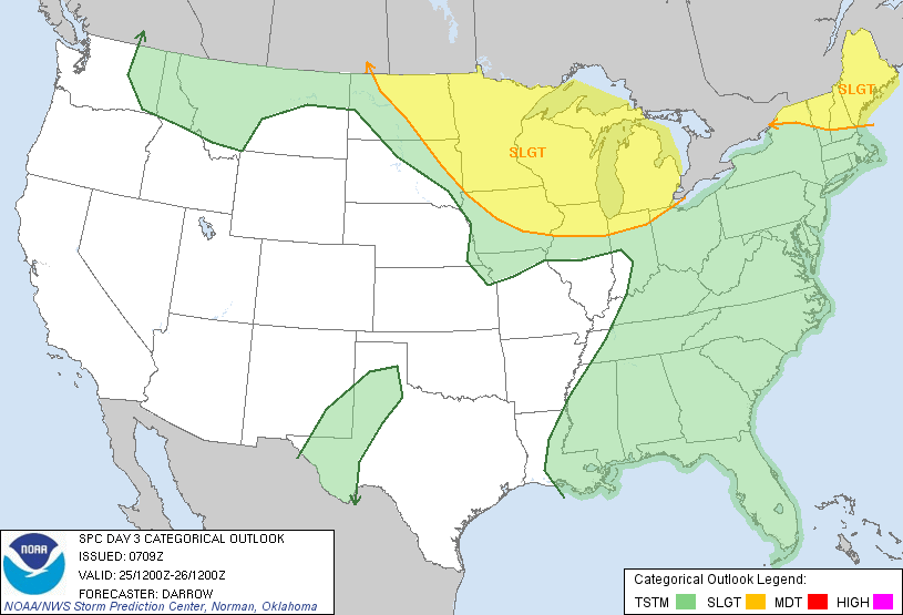
The Storm Prediction Center in Norman, Oklahoma has highlighted northern New England with a “Slight” Risk for severe thunderstorms for Tuesday. SPC notes that the environment will be favorable for rotating storms; but the main threat will likely be severe winds and hail.
Unfortunately toward the end of the forecast a return to cooler and wettter weather looks likely. A storm system looks to drop out of northwestern Canada and set up shop over the East Coast. But this is toward the end of the forecast and beyond and changes will likely need to be made.
7 DAY FORECAST
Sunday: Partly cloudy with highs in the upper 80s. Chance of an afternoon thunderstorm. Southwest wind 5-10 mph.
Monday: Partly cloudy with highs in the upper 80s. Humid!! Chance of an afternoon storm. West wind 5-10 mph.
Tuesday: Partly cloudy with highs in the upper 80s. Chance of a storm; especially in northern New England. Southwest wind 10-15 mph.
Wednesday: Partly cloudy with highs near 85. Slight chance of a shower or storm. Southwest wind 5-10 mph.
Thursday: Mostly cloudy with highs near 70. Chance of rain increasing throughout the day.
Friday: Mostly cloudy with rain. Highs in the 60s.
Saturday: Partly cloudy with highs in the mid 70s.
-Chris
An extremely late season nor’easter will impact our area beginning this morning and lasting through till tomorrow. In general this system will deliver 1-3″ of rain to the region. Of course localized higher amounts are definitely possible. If this were February, we would be talking about a wonderful blizzard. But unfortunately, it is June and we are talking about a lot of rain with rather unseasonably cool temperatures.
Currently our storm system is taking shape over the Ohio region and will strengthen as it moves east; eventually passing off the New Jersey coast and south of New England. This storm is going to bring severe weather to portions of the mid-atlantic; especially the Philly, Baltimore, and Washington regions. No severe weather is heading our direction. The only thing that we will have to be on the lookout for it some flooding. We have already had near 10″ of rain this June; with another couple on the way in the next day or so. Tis the recipe for some flooding.
If your looking for the return of summer………well keep looking. It is a ways off.
7 Day Forecast
Thursday: Rain moving in during the late morning hours. Highs in the low 60s. East wind 10-20 mph.
Friday: Rain during the morning. Tapering off around noon. Highs in the low 60s. Northeast wind 10-20 mph.
Saturday: Partly cloudy with afternoon highs in the low 70s. Northwest wind 5-10 mph.
Sunday: Partly cloudy with highs near 75. Chance of a shower or storm during the evening. Southwest wind 10-20 mph.
Monday: Chance of a morning shower. Highs in the mid 70s.
Tuesday: Slight chance of rain. Highs in the low 70s.
Wednesday: Chance of rain continues. Highs in the mid 60s.
-Chris
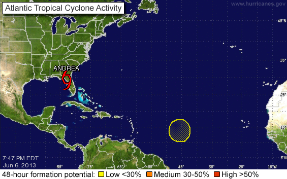
It did not take long for the Atlantic Hurricane Season to get underway. By definition Hurricane season started June 1st and we have already had our first system make landfall along the Florida coastline. Tropical Storm Andrea formed in the Gulf of Mexico and made landfall this evening with winds of 65 mph.
Andrea will be our weather maker tomorrow evening. She will bring lots of rain and very little wind. Tomorrow will be a cool day with highs in the upper 50s accompanied by off and on rain. The tomorrow night the remnants of Andrea will move in and deliver a couple inches of rain to the region.
Andrea should be gone by Saturday morning making for an overall cool, but nice weekend. Next week should feature afternoon showers and storms with no real heat wave. All in all except for tomorrow, the next 7 days look nice.
7 Day Forecast
Friday: Rain overnight. Off and on rain all day; becomes heavy during the evening and overnight. Highs around 55. Easterly wind 10-20 mph.
Saturday: Rain coming to an end during the morning. Afternoon highs in the upper 60s to near 70. Winds light 0-5 mph.
Sunday: Partly cloudy with highs in the mid to upper 70s. West winds 5-10 mph.
Monday: Isolated afternoon shower or storm. Highs in the upper 70s.
Tuesday: Isolated afternoon shower or storm. Highs around 75.
Wednesday: Partly cloudy with highs in the upper 70s.
Thursday: Partly cloudy with highs near 75.
-Chris
Been kind of hot our hasn’t it? It’s not the heat that is the problem, it is the humidity. Well usually air masses such as the one that we are in now are ended by a cold front. And that cold front is the mechanism that ignites thunderstorms. Which is what we have in the forecast for today.
In fact the Storm Prediction Center has issued a Severe Thunderstorm Watch for most of New England. A watch means that conditions are favorable for severe weather. This watch is in effect until 8 pm this evening.
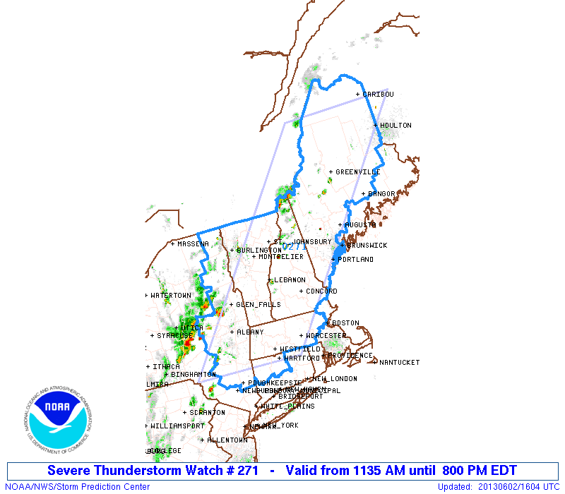
As you can see the watch covers most areas; excluding those areas immediately along the shoreline. SPC has declared the likelihood of tornadoes to be low, but the chances of severe wind are “Very High”. Also the chance of severe hail is moderate.
This afternoon could be a busy one. Storms have fired in Eastern New York state and they will make their way eastward throughout the afternoon. Storm will likely make it to the Worcester area by 3-4 pm. The 495 belt between 5-6 pm.
It is my expectation that the greatest likelihood for severe will be from Worcester westward as the line of storms will likely be dying as they push further east. That isn’t to say that we are off the hook. The main threat is damaging winds. So take your precautions just in case. Bring in loose furniture. Take down those patio umbrellas.
That way when the storm rolls through, if the weather does get bad, you aren’t running around in a lightning storm trying to pick everything up.
-Chris
