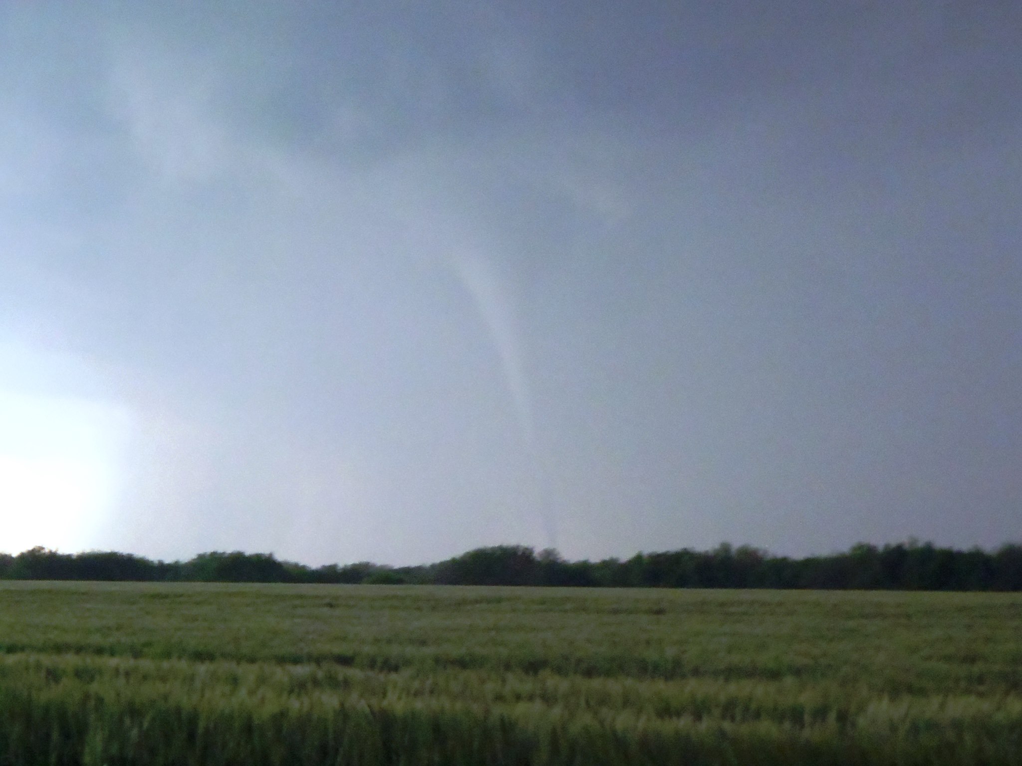
I’m sorry that I have been off the grid for last 3 weeks or so. It has been a very busy period as I was finishing up the school semester, moving and I went tornado chasing for 10 days.
While on the trip we witnessed numerous supercells, wall clouds and 1 tornado. We missed the tornado that devastated the areas of Newcastle & Moore Oklahoma by 30 miles or so on a different tornadic thunderstorm. This is the tornado that we witnessed on May 19th just north of South Haven, Kansas.
How about our upcoming weather? It’s been cool here in New England while I was gone. The mountains of Northern New England, and some lower elevation even received snow!! But that is not going to continue as the end of the forecast looks very warm!
Right now we have nary a cloud in the sky, but it is still cool. See that bank of clouds off to our southwest, that is a warm front. On the other side of that front is, well you guessed it warm air. Slowly but surely over the next couple of days, that front is going to move our direction. Eventually it will pass through during the evening on Wednesday. Which is the reason for rain in the forecast during the day on Wednesday.
Once that front passes through, our winds will shift to come from the south and southwest. Well, considering that I was just out over the southern plains, I can tell you that it is hot! So all that warm air that is located to our southwest is destined to make its way our direction with time. Which is why we will likely see our first 90 reading of the year in almost all locations.
This weekend is looking great and warm. Likely will be a good time to have a barbecue and open up those pools.
7 DAY FORECAST
Monday: Very sunny with highs around 70. West wind 5-10 mph.
Tuesday: Mostly sunny with highs in the low 70s. South wind 10-15 mph.
Wednesday: Mostly cloudy with rain during the afternoon. Highs in the low to mid 60s. Southwest wind 10-15 mph.
Thursday: Sunny and warm. Afternoon highs in the mid to upper 80s. Southwest wind 5-10 mph.
Friday: Warm again. Highs in the mid to upper 80s. West wind 10-15 mph.
Saturday: Hot! Afternoon highs near 90.
Sunday: Warm. Highs in the mid 80s.
-Chris
Remember that storm that brought a foot of snow to places in the upper midwest and then brought record cold temperatures to the deep south? Well it has finally made its way to us. Slowly but surely it is creeping its way up the East Coast. Today it will bring us a round of downpours with an embedded rumble of thunder. Likely sometime late this afternoon.
Unfortunately we can not get rid of it totally as it will bring another round of showers and downpours to us on Thursday. Friday looks great right now with highs in the upper 70s. I am being bold on this one and going with a high of 80.
As for the weekend forecast; it will be a tale of two halves. Saturday is not going to be all that nice. Looks like we will have a chance of rain all day long. Sunday however appears to be the better of the two days with highs in the low 70s.
Early next week looks fine but a bit cooler with highs only in the low 60s.
7 DAY FORECAST
Wednesday: Warm & humid. Rain moves in this afternoon. Embedded rumble of thunder. Highs around 70. Southwest wind 5-10.
Thursday: Mostly cloudy with rain by late morning. Highs 65-70. South wind 0-5 mph.
Friday: Partly cloudy with highs near 80. Southwest wind 5-10.
Saturday: Rain likely. Highs 55-60. Southwest 10-15 mph.
Sunday: Mostly clear with highs 70-75.
Monday & Tuesday: Partly cloudy with highs in the low 60s.
-Chris
While the weather here in New England has been spectacular for the last 10 days; conditions across other parts of the country have been quite extraordinary. An extremely late season cold airmass moved across the country. Dropping several inches of snow across the midwest and setting numerous records for coldest temperatures in the month of May.
The same system that brought these unusual conditions to parts of the country is going to be the weather maker that disrupts our string of amazing days. Clouds should make an appearance Tuesday and Wednesday followed by a chance of rain for overnight Wednesday through the day on Thursday.
Another chance at some showers is here Friday ahead of a cold front. Finally at the end of the period another overnight rain storm appears to be in the cards overnight Saturday into Sunday.
Temperatures are not going to be all that warm. Mainly staying in the mid 60s for the period. Cooler/warmer at times. Interesting to note, Northern New England is going to be warmer than Southern New England for the first few days of the forecast. Mainly due to the proximity to the coast. High pressure to our east has kept the skies clear, but cool.
7 DAY FORECAST
Monday: Mostly clear with highs around 65. South wind 0-5 mph.
Tuesday: Mostly cloudy with a high around 65. South wind 10-15 mph.
Wednesday: Mostly cloudy with highs 55-60. Southeast wind 5-10 mph. Rain moves in during late evening and lasts overnight.
Thursday: Rainy. Scattered showers and downpours. Highs 60-65. Northeast wind 0-5 mph.
Friday: Partly to mostly cloudy with highs in the low 70s. Chance shower/storm during the afternoon.
Saturday: Mostly cloudy with highs 55-60. Rain moves in during the late evening hours and lasts into the overnight.
Sunday: Cloudy to start; then clearing during the day. Highs around 60.
-Chris
