It is the middle of March right? Shouldn’t we be talking about Spring? Warmer temperatures…..blooming flowers……..and golf. But nope, all of these are on hold for right now. We have a snow storm to talk about.
But first why do we have a snow storm? This all boils down to the atmospheric pattern over the North Atlantic and the fact that we have a cold enough air mass for snow. Right now over the North Atlantic we have a blocking pattern which gives rise to a negative NAO. The NAO is a way of quantifying the interaction between the Icelandic Low and the Azores High. When the NAO is negative, this favors storm tracks that impact New England. Recent examples of a negative NAO are Hurricane Sandy and the last month of winter.
Tomorrow’s Storm:
Right now our storm system is bringing a Blizzard to parts of the Northern Plains. The primary area of low pressure is going to track towards Lake Michigan. When it gets there it will slow down and begin to die. As the storm is dying, the best location for storm development is now to the East-southeast of the old storm. Tomorrow morning a new storm center will begin to develop near Atlantic City, New Jersey. This storm will travel across Southern New England, very near to the Cape Cod Canal. From here it will track into the Gulf of Maine and slowly move away.
Timeline:
Snow should begin to move in around Midnight tonight and will move in from southwest to northeast. Precipitation will begin as snow everywhere. By the morning commute it should be raining on Cape Cod and most of Connecticut will most likely be experiencing a mix of rain, snow and more likely sleet. There will be two periods of heavier precipitation, one during the morning commute and one during the mid afternoon. By noon most places south of the Mass Pike will have mixed with rain or sleet. Determining where the rain/snow line comes to a stop is key to snow totals; but it is also very challenging and one that can not be forecasted with much confidence. Mainly because it is March.
Precipitation:
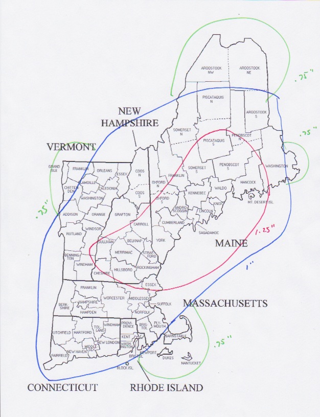
Tomorrow’s storm is going to bring a general inch of precipitation to most. Which is still significant, but not a lot when compared to our last two big storms. As for my thinking on how much water a location will receive, see below:
Snowfall:
Tomorrow’s storm is going to be a tricky forecast. It is March. The sun is getting stronger. The days are longer. There is a lot that could possibly go wrong. But that is the fun of it right? Creating a forecast and standing by it even though so many factors way into one’s decisions.
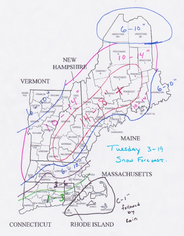
As you can see snowfall amounts increase from south to north. Places that stay all snow should be looking at 10″+. And places in interior Maine and central New Hampshire could be looking at a foot and a half.
Looking Ahead:
We might not be out of the woods just yet. This might not be Winter’s last gasp. The NAO is still negative. And it is still going to be cold. With a negative NAO we will have storm chances. With cold air firmly in place we will have chances for snow. And our next chance might just be Thursday into Friday. Right now it might be just offshore, but as always it will have to be watched.
-Chris
