This storm is going to be one that will test the forecasting skills of even the most seasoned forecaster. What we have unfolding is not a typical nor’easter; but a scenario in which the storm system will be so large that even though the center will be hundreds of miles away, SNE will feel some impacts.
TIMELINE
During the day on Wednesday, flurries and snow showers could over take the region. These are from what is left of the storm to our northeast. Overnight Wednesday and Thursday our next storm will take shape off the Carolina Coast. We will sit and await the precipitation shield as it slowly rotates northwest toward and eventually into our region. During the day Thursday light snow or rain are possible. It isn’t until Thursday evening that the heavier precipitation and consequently the bulk of the accumulating snow gets here. The storm doesn’t entirely wind down until sometime during the day Friday, but most accumulations should be done by then.
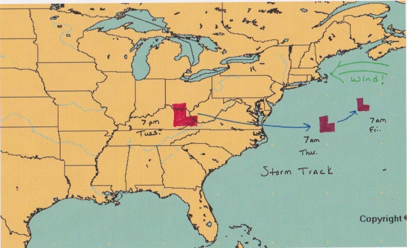
What makes this an odd scenario is that the storm center will be tracking well to the south of New England. Normally such a track would leave us waving as the storm passed us by; but not this time. Notice how the storm did not move all that much from Thursday morning to Friday morning! What has happened is that the system has run into an atmospheric wall (known as a blocking pattern) that is set up over the North Atlantic. Coinciding with the running into the blocking pattern the system will also be undergoing occlusion. Meaning that it has reached it’s peak strength and will slowly begin to die. As this occurs, the storm’s precipitation shield will become displaced from the center. Positioning itself over Southern New England. Combine this fact with a strong easterly wind off the Atlantic Ocean and that gives you a recipe for a lot of water to fall from the sky.

Above is the amount of water that I expect to fall from the sky. The very challenging part is how much of this water ends up falling (and accumulating!!) as snow?
We have a few things working against us. 1. It is early March. Not really the dead of winter. 2. Bad air mass prior to event. Not exactly that cold out. 3. Strong east wind off ocean. Marine air.
But what we do have working in our favor is the potential precipitation rates. If it is snowing hard enough, then the flakes will not have enough time to melt before reaching the ground. It is during these times of very heavy snowfall that most of the accumulations should occur.
Also working in our favor is that the times of heaviest snow will likely be after dark Thursday evening. It is during this time, between 5 pm Thursday and 5 am Friday that most accumulations should occur.
As for total accumulations for this event here is my map.
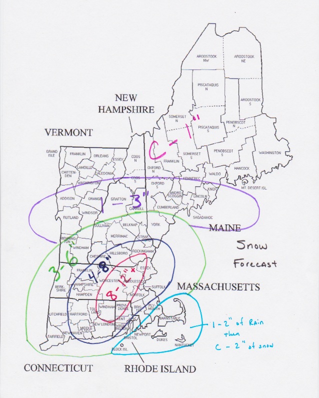
I’m going to be honest when I say this was a very tricky forecast and that there are a lot of things that could potentially go wrong. The biggest potential problem is that the heaviest of precipitation rates do not make it into Southern New England. Leaving us with a few slushy inches and possibly more rain than snow. But right now my map above represents where I feel we stand.
OTHER IMPACTS
Wind: This storm is going to be very windy. Winds just above our heads will be greater than 50 knots. Which means that we could see wind gusts on the order of 50 to 60 mph. Along the coastline gusts of 50 mph will be fairly frequent. Power outages are a definite possibility.
Waves/surge: The combination of a powerful system and a constant easterly wind for 2 or more days will create some very large waves over the North Atlantic. Some wave models are suggesting 20-30 foot waves will be the norm just offshore. Beach erosion is a certainty along with coastal flooding in areas that are prone to flooding.
Power Outages: As I mentioned in the wind section above, power outages are possible. The combination of very heavy wet snow and strong winds make for a good limb snapping/power line breaking combination. Areas south of Boston are more likely to lose power, but strong gusts are expected everywhere so power outages could occur anywhere.
Again the bulk of the accumulation snow is expected overnight Thursday and into Friday morning. So please do not think the storm isn’t coming if during the day Thursday if it is raining or the snow is not all that impressive.
Fingers crossed this one goes as planned!!!
-Chris
