Finally! We have a storm that will form off the East Coast and miss New England, for the most part. Tonight’s storm will stay just far enough away that the most it should bring is a few snow flakes to southern areas with possibly an inch along the South Coast.
Unfortunately though we don’t really warm up all that much this week. The same atmospheric pattern we have been stuck in will continue. But it is eroding. Slowly but surely it is losing its grip on us. Which is why some 50s pop up in the forecast towards the end of the week.
Nothing very impactful is ahead this week. There is a chance for a sprinkle or a flurry Wednesday, Thursday and Saturday, but nothing major until possibly Monday. But that is day 7 and we all know how accurate day 7 forecasts can be.
7 DAY FORECAST
Monday Night: Storm center moves south of New England. Flurries for many. Inch for some along the South Coast. Lows around 30. North wind 10-15 mph.
Tuesday: Mostly cloudy with some breaks in the clouds. Highs around 45. North wind 10-15 mph.
Wednesday: Partly cloudy with the chance of a sprinkle. Highs around 45. West wind 10-15 mph.
Thursday: Chance of a shower. Highs 40-45. North wind 10-15 mph.
Friday: Partly cloud with highs around 50.
Saturday: Chance of a sprinkle. Highs around 50.
Sunday: Warm. Highs around 55.
Monday: Storm system will pass near New England. Will be monitored. Highs 45-50.
-Chris
It is the middle of March right? Shouldn’t we be talking about Spring? Warmer temperatures…..blooming flowers……..and golf. But nope, all of these are on hold for right now. We have a snow storm to talk about.
But first why do we have a snow storm? This all boils down to the atmospheric pattern over the North Atlantic and the fact that we have a cold enough air mass for snow. Right now over the North Atlantic we have a blocking pattern which gives rise to a negative NAO. The NAO is a way of quantifying the interaction between the Icelandic Low and the Azores High. When the NAO is negative, this favors storm tracks that impact New England. Recent examples of a negative NAO are Hurricane Sandy and the last month of winter.
Tomorrow’s Storm:
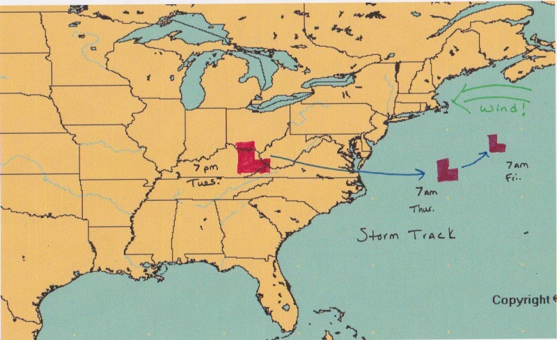
Right now our storm system is bringing a Blizzard to parts of the Northern Plains. The primary area of low pressure is going to track towards Lake Michigan. When it gets there it will slow down and begin to die. As the storm is dying, the best location for storm development is now to the East-southeast of the old storm. Tomorrow morning a new storm center will begin to develop near Atlantic City, New Jersey. This storm will travel across Southern New England, very near to the Cape Cod Canal. From here it will track into the Gulf of Maine and slowly move away.
Timeline:
Snow should begin to move in around Midnight tonight and will move in from southwest to northeast. Precipitation will begin as snow everywhere. By the morning commute it should be raining on Cape Cod and most of Connecticut will most likely be experiencing a mix of rain, snow and more likely sleet. There will be two periods of heavier precipitation, one during the morning commute and one during the mid afternoon. By noon most places south of the Mass Pike will have mixed with rain or sleet. Determining where the rain/snow line comes to a stop is key to snow totals; but it is also very challenging and one that can not be forecasted with much confidence. Mainly because it is March.
Precipitation:
Tomorrow’s storm is going to bring a general inch of precipitation to most. Which is still significant, but not a lot when compared to our last two big storms. As for my thinking on how much water a location will receive, see below:
Snowfall:
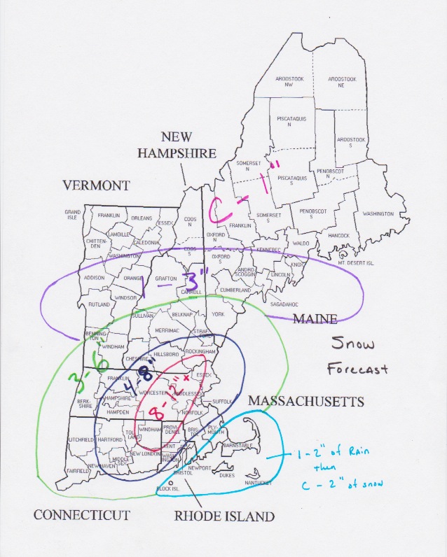
Tomorrow’s storm is going to be a tricky forecast. It is March. The sun is getting stronger. The days are longer. There is a lot that could possibly go wrong. But that is the fun of it right? Creating a forecast and standing by it even though so many factors way into one’s decisions.
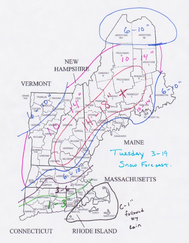
As you can see snowfall amounts increase from south to north. Places that stay all snow should be looking at 10″+. And places in interior Maine and central New Hampshire could be looking at a foot and a half.
Looking Ahead:
We might not be out of the woods just yet. This might not be Winter’s last gasp. The NAO is still negative. And it is still going to be cold. With a negative NAO we will have storm chances. With cold air firmly in place we will have chances for snow. And our next chance might just be Thursday into Friday. Right now it might be just offshore, but as always it will have to be watched.
-Chris
Unfortunately Winter is not over yet! We have another storm coming for Tuesday. A storm system is going to track towards the Great Lakes, bringing Blizzard conditions to parts of the Northern Plains. As this system reaches the Great Lakes and begins to die a new storm center will take shape very near to Long Island. This storm center will then track over Southeastern Massachusetts and into the Gulf of Maine.
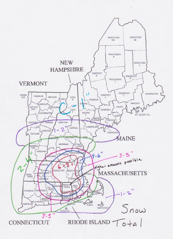
So what can we expect? Everyone should start as snow. Snow will move in during the very early hours of Tuesday morning. As the storm gets closer and the sun comes out, most everyone will see a change to sleet, ice, freezing rain, and eventually plain old rain. This transition will occur from south to north. Meaning that places like Worcester and Northern Mass will stay as snow longer than a place like Providence or Boston. Which means that snow totals will increase from south to north.
Places such as the Worcester Hills and anyone north of Massachusetts will likely stay all snow. This is going to be a strong storm, so those locals that remain all snow should be looking at a foot plus easy. In Southern New England totals will vary greatly and are all dependent on how long one stays as snow. Places south of the Mass Pike could be looking at a 2-4 inch type event. Place north of it more like a 4-8 inch type. And again those higher elevation locals that stay as snow 12″+.
I’m am holding off on a snow map for now (look for one tomorrow) as this is a difficult set-up to forecast and is all dependent on the final track of the storm center and timing of precipitation. While I am confident in everything I just told you; there is still enough uncertainty (and the fact that it is mid-March) that I will hold the snow map until tomorrow.
As a side note I am rooting for rain. That’s right rain. Winter had her fun it is now time for golf!
-Chris
Sometimes March can be kind, like the last few days. And othertimes March can be not so kind, like our next 7 days or so. The last few days have been pretty nice around here. Temperatures reaching into the upper 40s and low 50s. Just a sign that Winter might be losing it’s grip, but unfortunately she hasn’t completely let go just yet.
For those of you who can’t wait for Winter to end and for Spring to come, technically it is already Meteorological Spring; which began back on March 1.
The progress that we made towards Spring the last few days will come to end. After today, the next week or so looks to be a little below normal. For this time of the year our normal high temperature is in the low 40s to near 45. But after today most of our highs look to struggle to reach 40. Throw in the occasional weather system and our next week doesn’t look so nice.
But don’t worry I am not expecting any big snow storms and just remember that with every day the sun is getting stronger and our days are getting longer.
7 DAY FORECAST
Wednesday: Partly cloudy skies with highs around 50. West wind 5-10 mph.
Thursday: Mostly cloudy with highs only in the upper 30s. West wind 10-15 mph.
Friday: Partly cloudy to start; becoming mostly cloudy. Highs 35-40. West wind 10-15 mph.
Saturday: Chance of precipitation in the afternoon in Southern New England. Rain likely, but snow possible in the higher elevations. Highs around 35.
Sunday: Partly cloudy with highs around 35.
Monday: Chance of snow overnight. Nothing big. Daytime highs in the upper 30s.
Tuesday: Looking like a cold miserable rain with highs 35-40. Change in track could bring snow. Will keep eye on.
-Chris
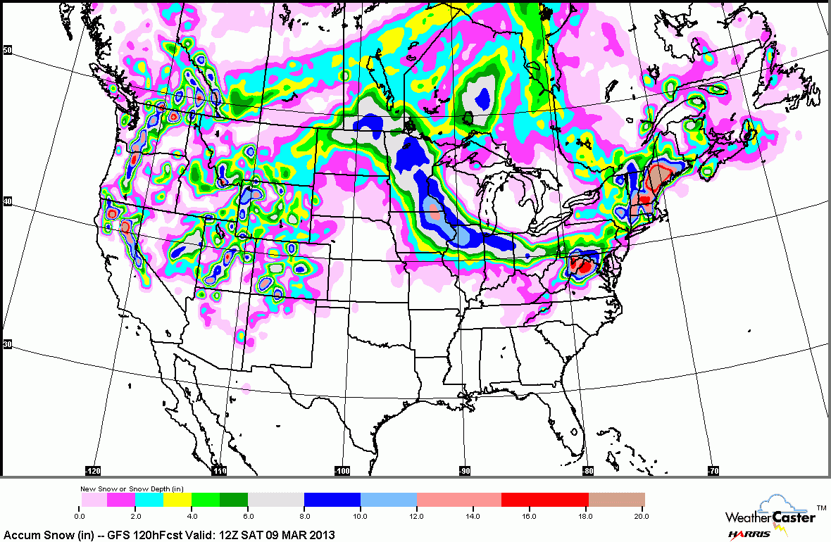
The overall forecast is on track. A large powerful storm is taking shape off the Virginia Coast. As the system drifts east it’s precipitation shield will expand to be large enough to include Southern and Central New England.
Precipitation should move in overnight tonight. It will be light at first, eventually picking up in rate later in the afternoon. Do not be surprised if it starts as rain. Also do not be surprised if at times it is snowing, raining, sleeting or all of the above. It is during the times of heavier precipitation that snow will be found.
As we get towards supper Thursday evening a few things begin to work in our favor for snow. The sun will be setting and precipitation rates will pick up. Allowing for snow to move in and to begin accumulating.
During the day Thursday accumulations will be minimal or non-existant. Overnight Thursday into Friday morning is when the accumulations will occur. (See map above).
The storm does not finally move away until Friday afternoon. Meaning that snow could possibly end as rain in some places Friday.
Looking further ahead, the weekend looks nice.
OTHER IMPACTS
Wind: This storm is going to be very windy. Winds just above our heads will be greater than 50 knots. Which means that we could see wind gusts on the order of 50 to 60 mph. Along the coastline gusts of 50 mph will be fairly frequent. Power outages are a definite possibility.
Waves/surge: The combination of a powerful system and a constant easterly wind for 2 or more days will create some very large waves over the North Atlantic. Some wave models are suggesting 20-30 foot waves will be the norm just offshore. Beach erosion is a certainty along with coastal flooding in areas that are prone to flooding.
Power Outages: As I mentioned in the wind section above, power outages are possible. The combination of very heavy wet snow and strong winds make for a good limb snapping/power line breaking combination. Areas south of Boston are more likely to lose power, but strong gusts are expected everywhere so power outages could occur anywhere.
Again the bulk of the accumulation snow is expected overnight Thursday and into Friday morning. So please do not think the storm isn’t coming if during the day Thursday if it is raining or the snow is not all that impressive.
-Chris
This storm is going to be one that will test the forecasting skills of even the most seasoned forecaster. What we have unfolding is not a typical nor’easter; but a scenario in which the storm system will be so large that even though the center will be hundreds of miles away, SNE will feel some impacts.
TIMELINE
During the day on Wednesday, flurries and snow showers could over take the region. These are from what is left of the storm to our northeast. Overnight Wednesday and Thursday our next storm will take shape off the Carolina Coast. We will sit and await the precipitation shield as it slowly rotates northwest toward and eventually into our region. During the day Thursday light snow or rain are possible. It isn’t until Thursday evening that the heavier precipitation and consequently the bulk of the accumulating snow gets here. The storm doesn’t entirely wind down until sometime during the day Friday, but most accumulations should be done by then.
What makes this an odd scenario is that the storm center will be tracking well to the south of New England. Normally such a track would leave us waving as the storm passed us by; but not this time. Notice how the storm did not move all that much from Thursday morning to Friday morning! What has happened is that the system has run into an atmospheric wall (known as a blocking pattern) that is set up over the North Atlantic. Coinciding with the running into the blocking pattern the system will also be undergoing occlusion. Meaning that it has reached it’s peak strength and will slowly begin to die. As this occurs, the storm’s precipitation shield will become displaced from the center. Positioning itself over Southern New England. Combine this fact with a strong easterly wind off the Atlantic Ocean and that gives you a recipe for a lot of water to fall from the sky.

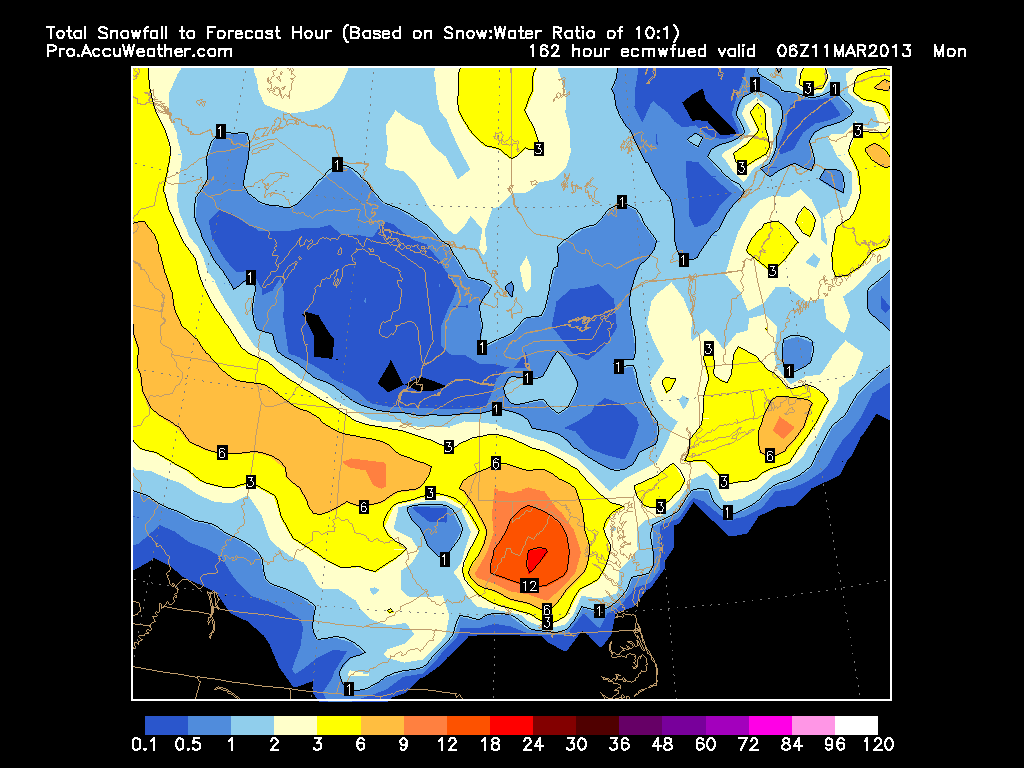
Above is the amount of water that I expect to fall from the sky. The very challenging part is how much of this water ends up falling (and accumulating!!) as snow?
We have a few things working against us. 1. It is early March. Not really the dead of winter. 2. Bad air mass prior to event. Not exactly that cold out. 3. Strong east wind off ocean. Marine air.
But what we do have working in our favor is the potential precipitation rates. If it is snowing hard enough, then the flakes will not have enough time to melt before reaching the ground. It is during these times of very heavy snowfall that most of the accumulations should occur.
Also working in our favor is that the times of heaviest snow will likely be after dark Thursday evening. It is during this time, between 5 pm Thursday and 5 am Friday that most accumulations should occur.
As for total accumulations for this event here is my map.
I’m going to be honest when I say this was a very tricky forecast and that there are a lot of things that could potentially go wrong. The biggest potential problem is that the heaviest of precipitation rates do not make it into Southern New England. Leaving us with a few slushy inches and possibly more rain than snow. But right now my map above represents where I feel we stand.
OTHER IMPACTS
Wind: This storm is going to be very windy. Winds just above our heads will be greater than 50 knots. Which means that we could see wind gusts on the order of 50 to 60 mph. Along the coastline gusts of 50 mph will be fairly frequent. Power outages are a definite possibility.
Waves/surge: The combination of a powerful system and a constant easterly wind for 2 or more days will create some very large waves over the North Atlantic. Some wave models are suggesting 20-30 foot waves will be the norm just offshore. Beach erosion is a certainty along with coastal flooding in areas that are prone to flooding.
Power Outages: As I mentioned in the wind section above, power outages are possible. The combination of very heavy wet snow and strong winds make for a good limb snapping/power line breaking combination. Areas south of Boston are more likely to lose power, but strong gusts are expected everywhere so power outages could occur anywhere.
Again the bulk of the accumulation snow is expected overnight Thursday and into Friday morning. So please do not think the storm isn’t coming if during the day Thursday if it is raining or the snow is not all that impressive.
Fingers crossed this one goes as planned!!!
-Chris
The meteorological community has been a buzz today with what our computer guidance models are beginning to advertise. Remember in the last blog where I mentioned a large ocean storm for the Thursday time frame? Well for the longest time it looked as if the system would skirt to our south and only impact New England with large surf.
Well yesterday one of our computer guidance models came in with a rather substantial snowstorm for Southern New England. Through this afternoon that same model has only become more substantial in it’s potential impacts. BUT in addition, the other computer guidance models have taken steps toward the large impact scenario.
So right now what I would like to do is outline two different scenarios. Which I feel have equal chances of being correct.
The first is the extreme solution. Which includes 1 to 2 feet of snow for some locations across Southern New England. This is the scenario being outlined by the GFS model, the SREF and now the NAM. Those colors over portions of New England range from 4-20″ of snow.
Meanwhile the other scenario is one in which the storm just skirts us to the south and while most of the region still sees some flakes, it is no where near the impact of what I described above. This scenario is being supported by the Euro, CMC and UKMET. As can be seen, this scenario only shows a couple of inches of snow.
Which one is right is the big question of course!!! Honestly there is a 50/50 chance that either scenario will happen and more than likely the truth lies somewhere in between. Will wait until tomorrow morning to issue a true forecast. Until then just keep in the back of your mind that a storm is coming and that it has the potential to be rather significant.
-Chris
Last post I talked about the rain system that impacted us on Wednesday and I mentioned how the system was basically going to die and rot over our heads. Well it is now Friday and that same system is still sitting on our heads. Which is the reason for all the gray clouds and sometimes dreary look to the sky.
Well luckily this system has become just a nuisance and except for portions of Eastern Maine, just a cloud maker. This will be our weather for the next few days. Lots of clouds with the occasional break in the clouds allowing us to see the sun.
Below is the forecasted 500 mb vorticity map for 1 pm Friday afternoon. Notice how the system is still centered over New England. The system has really weakened and is represented by the black contour labeled 534.
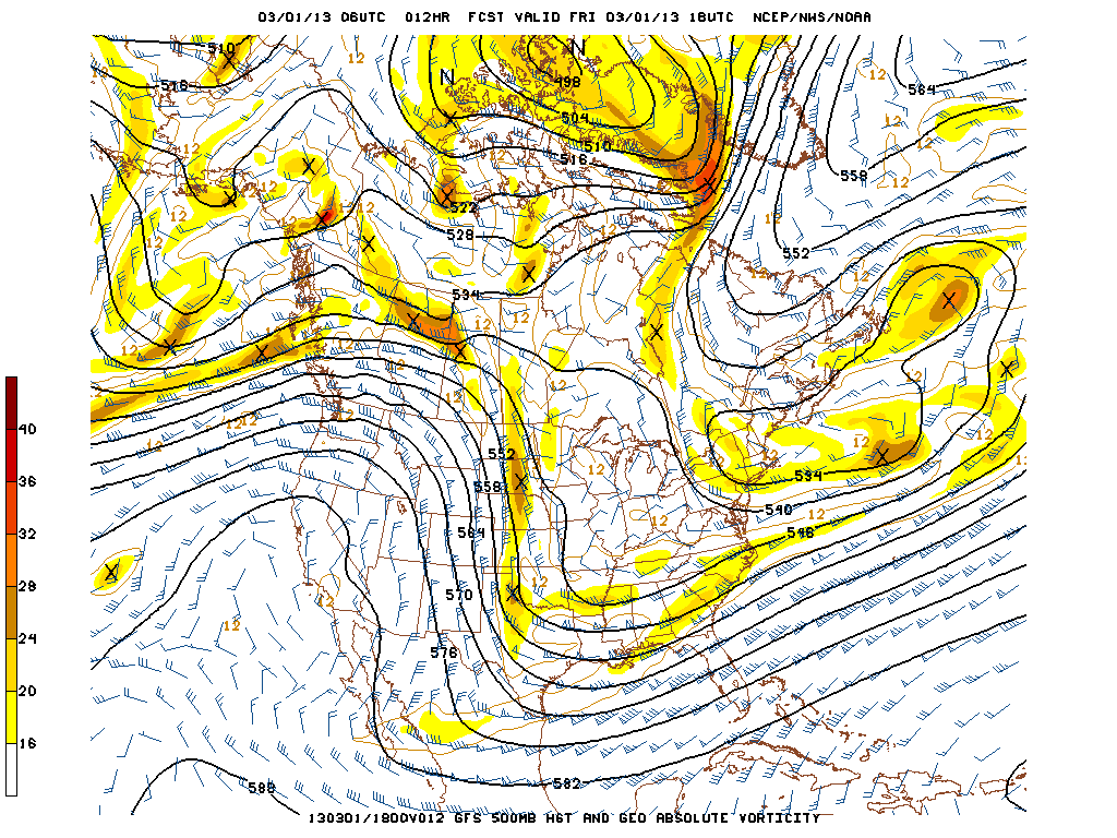
Also of note is the “tongue” like feature to our North and East. What I am describing is the shape the contours south of the tip of Greenland (the 564, 558, 552 black lines) make. From the top of the image towards Canada, they appear to make a tongue. The black lines (contours) and the blue-ish wind barbs are representative of the flow at this level of the atmosphere. What this is showing meteorologically is that the flow is congested over the North Atlantic and that storm systems trying to move off the East Coast have no where to go. We call this a blocking pattern. It is a pattern like this that allowed Hurricane Sandy to impact the East Coast. And a pattern like this that would allow for a rather significant snow storm if one were to form. *Hint* *Hint*
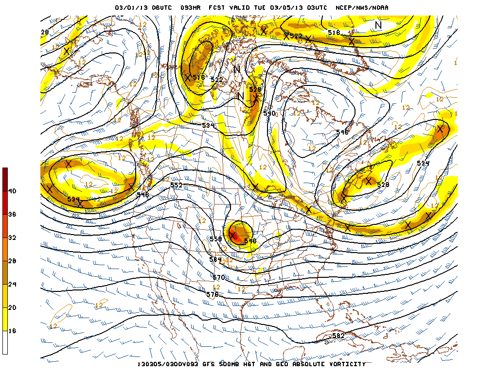
The next image is the forecasted 500 mb vorticity for Monday night at 10 pm. Just wanted to point out that our same storm system is still sitting and spinning just to our north and east. But I also wanted to point out that area of energy over Kansas and Nebraska. We may have to keep an eye on that one for later next week.
But for today and the weekend expect lots of clouds with the occasional gap that allows us to receive some sunshine. Daily temperatures will be in the low 40s each day. And eastern Maine will have to be weary of the occasional batch of light snow rotating around the system overhead.
Looking ahead to next week, Monday through Wednesday appear to be dry with highs in the 40-45 range. Thursday and Friday we will be keeping an eye on the system I mentioned above. Right now all computer guidance suggests that a significant storm will form somewhere off the East Coast. The question is really just to where. This one will definitely have to be monitored in the coming days.
7 DAY FORECAST
Friday: Mostly cloudy with the occasional break in the clouds. Light batches of snow for eastern Maine. Highs in the low 40s. West wind 5-10 mph.
Saturday: A repeat of Friday really. Mostly cloudy with those sporadic breaks showing the sun. Highs around 45. West-northwest wind 5-10 mph.
Sunday: Partly to mostly cloudy with highs around 40. West-northwest wind 0-5 mph.
Monday: Partly cloudy with highs in the low 40s. West winds 10-15 mph.
Tuesday: Partly cloudy with highs 40-45.
Wednesday: Partly cloudy with highs around 40.
Thursday: Mostly cloudy with a chance for snow. Keeping an eye on this one. Highs in the mid 30s.
-Chris
