Remember in my last forecast when I issued a snow map for last weekend and I mentioned how I was lacking confidence? Well last weekend was a learning experience for myself. I learned that I should never issue a snow map that identifies deterministic snow totals when I do not have complete confidence in my forecast. That I should always air on the side of caution and remember that there is a reason for my lacking in confidence.
Last weekend was also an unfortunate in terms of timing. I issued my snow map late in the afternoon on Thursday. Up until that point there had been a rather good amount of agreement between the computer models in terms of the weekend snow forecast. But as I was creating my map, a few of the models came in with a scenario that did not agree with my forecast. Which led to me lacking confidence when I published the snow map. What was unfortunate was that Friday morning I went on a weekend trip to a location that did not have any wifi. Which is why I did not update everyone on the storm and why my final forecast prior to the event was so terrible.
But from every mistake something new is learned. And I have realized that every forecasting mistake I make is a blessing in disguise in that for some reason it becomes ingrained in my memory bank and I can draw on those mistakes to make a better forecast in the future.
Enough about last weekend though. How about this week ahead? Unfortunately it does not appear to be all that great. A storm system is going to track to our west and die. When it does a new system will form along the East Coast and track our direction. Right now it looks to be a mixed bag of precipitation. Possibly starting as snow, then transitioning to rain, while stopping at all other precipitation forms in between. Places could see freezing rain and sleet from this one. Truly a mixed bag of precipitation. Also, this storm system will run into an atmospheric wall so to speak and will be stuck over our heads for a few days. Giving New England the chance of a rain or snow shower from Wednesday through Saturday.
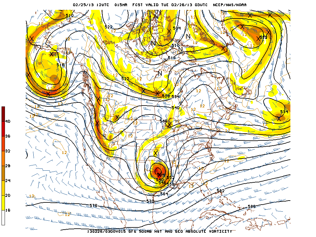
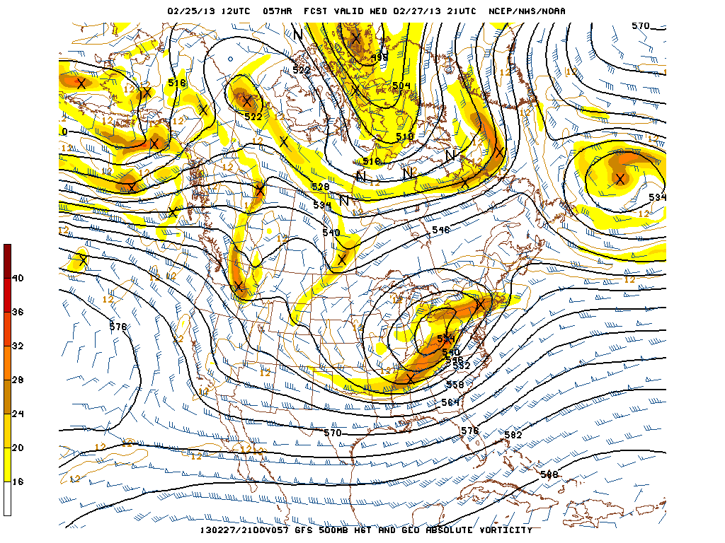
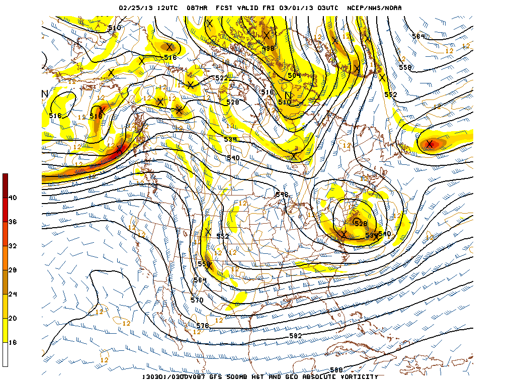
To give you a visual of what I am talking about I have selected the following three images. The images are from the GFS model and they are of 500 mb Heights & Vorticity. If you remember from some of our previous blogs that vorticity can be thought of as energy. It is the energy in the atmosphere that helps create upward vertical motion which is necessary for storm formation.
This first image is forecasted for tonight at 10 pm. The area of interest is the big ball of vorticity (shaded regions) in northwest Texas and southeast Oklahoma. Of importance is the closed height contours (black lines) surrounding the system. The system is no longer an open wave and is very near it’s peak intensity.
This forecasted image is for Wednesday afternoon at 4 pm. We can see that our storm system has really only drifted to the northeast to the Ohio River Valley. It is at this time that New England is in a favorable location for positive vorticity advection (upward motion) and we will most likely be getting rained on. Higher elevations could see snow.
This final image is forecasted for 10 pm Thursday night. Notice how the system is now centered over Southern New England. Also noticed how the shaded regions have decreased in intensity. Evidence that the system has slowly been dying. But also notice how that all of New England is surrounded by vorticity. This is why most of the forecast includes a chance of a snow or rain shower.
7 DAY FORECAST
Tuesday: Mostly cloudy with afternoon highs in the low 40s. North-northeast winds 5-10 mph.
Wednesday: Rain/snow moves in from southwest to northeast after midnight. This is a very tricky forecast. It will all depend on the northward push of warm air. If it gets far enough north, rain is likely. If it gets stopped and runs into a wall; then we could see all forms of precipitation from rain to snow to sleet to freezing rain. Highs around 40 with a north wind at 15-20 mph.
Thursday: Heaviest precipitation has moved away, but everyone still has a chance of a rain or snow shower. Highs in the mid 30s. Variable winds 10-15 mph.
Friday: Chance of a rain or snow shower in Eastern New England. Highs 35-40.
Saturday: Chance of a snow shower in the state of Maine. Partly to mostly cloudy elsewhere. Highs around 40.
Sunday: Weather continues to improve. Probably see the sun this day. Highs around 40.
Monday: Partly cloudy with highs around 35.
-Chris
