Another day has gone by and we are still on track to be impacted by a snowstorm the likes of which we have not seen in quite a while. The closer that we get to the storm the more and more the computer guidance is beginning to resemble the Blizzard of 1978. In fact from a meteorological stand point this storm could bring more snow and just as much wind as the 1978 edition brought.
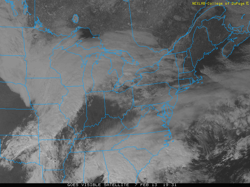
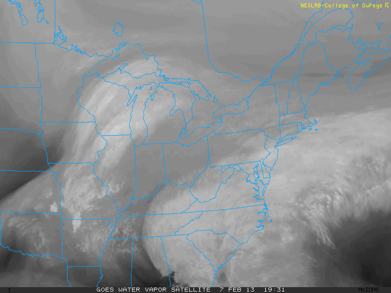
Where do we stand right now? The following two images are visible and water vapor image stills of the Eastern U.S. Right now our storm is still in two pieces, but one can look at the image and just know that something big is about to occur.
What we have are two pieces of energy moving across the U.S. One piece is moving along the Polar Jet Stream and is located near eastern Iowa. The second piece is moving along the Subtropical Jet Stream and is just west of Atlanta.
It is these two pieces combining into one that will bring us our storm.
SYNOPTIC OVERVIEW:
Yesterday I outlined how the two pieces of energy were going to act and move across the country, but it can not hurt to do this again. Both pieces of energy are making a beeline for just off the New Jersey coast where they will come together and phase into one very intense storm.
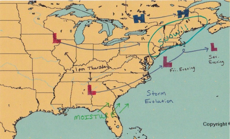
The image below is my attempt to illustrate how the two pieces of energy, marked by the X’s, will move and act over the next 3 days. Of importance to note is the loop that the storm performs just south of the Island of Nantucket.
When these two systems come together, they will spawn an intense storm. But this storm can only become so strong. When the system reaches it’s point of maximum intensity it undergoes what is known as occlusion. When this occurs the storm’s forward movement become almost non-existent. Giving way to the loop.
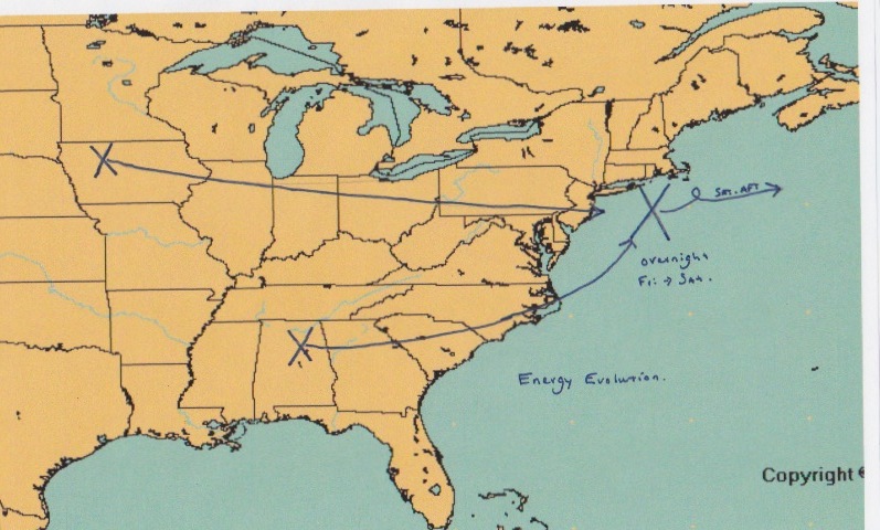
As for what I think the surface reflection is going to look like, that is as follows. Note the two storm systems combining into one off the Mid-Atlantic coast. Also note the loop that the storm performs south of Nantucket. As the upper level energy occludes, it will essentially reach out and grab the surface system. Slowing the low pressure’s movement and in fact possibly performing this loop.
This loop is important. The Blizzard of ’78 did this. This loop turns our storm from a 24 hour event into a 36 hour event. Just adding to the possible snow totals.
Also of importance is the area of High Pressure in southeastern Canada. This High is in a textbook location for getting our biggest snow storms. It does two things for us. It will slow the storm’s progress and it will supply the region with plenty of cold air. Put everything together and we have a lot of snow.
TIMELINE:
8 to 10 AM: Light snows overspread the region. Just enough to notice. Accumulations will be minimal.
1 to 3 PM: Snowfall increases in intensity. Snow accumulations are underway. A few inches are likely. I would advise that everyone be off the roads and home by 3 pm.
5 to 7 PM: Heavy snow moves in. Snowfall rates of 1 to 3 inches per hour. This is when we pick up our feet of snow. Accumulations will be measured in feet and not inches. The heaviest of the snow lasts from 7 pm until noon on Saturday (possibly a little longer)
Noon Saturday: Snow should begin to taper off. It might linger through the evening, but the major accumulations will be done by this time.
FORECAST:
So now that we have the synoptic overview and the timeline. Let’s complete the forecast. I will be honest, when I was making this forecast I was having trouble. Not because the forecast was that difficult, but because the forecast I was coming up with is almost impossible to believe. In fact, the forecast was fairly easy considering the amount of agreement in the guidance. It was the idea of forecasting snow totals of multiple feet that was the problem.
What I am trying to say is that it is not easy to put together a forecast for something that I have never seen before.
Yesterday we looked at the total amount of liquid precipitation I expected to fall from the sky. Well after another day of computer model runs I have recalculated that and it is as follows.
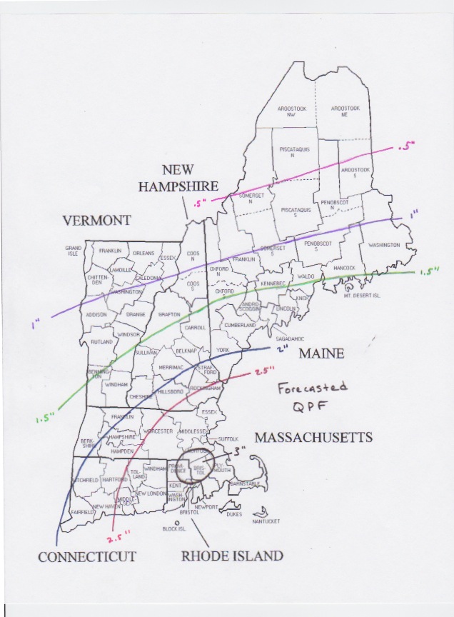
Now that we have the liquid forecast, we can turn this into a snowfall forecast. One that was giving me chills as I was making it because this type of snow map is one that I used to draw when I was a young child dreaming of the perfect snow storm.
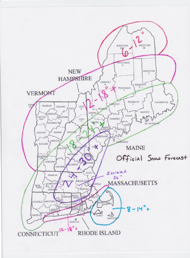
As you can see I have almost all of New England receiving a foot or more of snow. Except for extreme northern Maine, this is going to be a significant to historic snow storm.
Please take this one seriously, I have not seen a storm with potential like this ………ever.
NATIONAL WEATHER SERVICE:
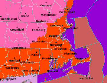
The following image is the from the NWS at Taunton. This is their warning map for our area. The bright orange colors are Blizzard Warnings. The pink area is Winter Storm Warnings. The green color that we can’t see is for a Coastal Flood Warning along all coastlines. The maroon color offshore is for a Hurricane Wind Warning. Or simply put, all of the strongest worded warnings that Taunton can use, they are.
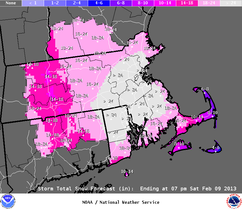
The following image is Taunton’s snowfall forecast. These are the guys that are getting paid for this so I figured I would show it to back up what I am saying.
OTHER IMPACTS……..like WIND:
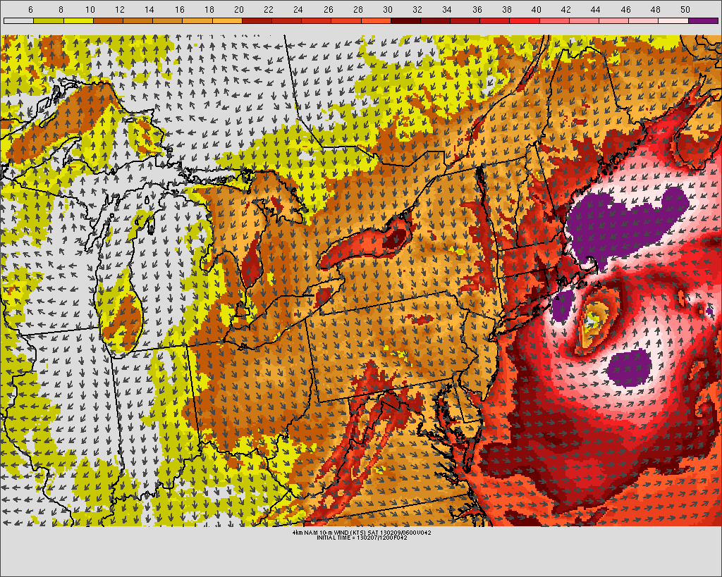
The winds generated from this system are going to be impressive. Sustained winds could be on the order of 30-40 mph. Gusts could be as high as 60 mph. Over the Cape and immediately coastline, hurricane force winds are possible. Meaning power outages are probable.
The following image is just one models depiction of what the winds could possibly look like. The whites and purples are pushing 60+ mph. The oranges and reds for everyone are 40+ mph. Blowing and drifting snow is a given. Blizzard conditions for all are likely.
THE OCEAN:
One of the impacts that not many people are touching on is the potential danger from waves and surge that our beaches are facing. In addition to possible wind damage, beaches and places near the water should worry about erosion from storm surge and massive waves. At it’s peak intensity, this system is going to mirror a hurricane. The combination of wind whipped waves and a storm surge on the order of 3 to 4 feet will take a toll on the beach and those near the beach. Places that tend to experience coastal flooding from our stronger storms should expect that to happen again. The time to prepare is now. Don’t wait until your first floor is under water to get out.
PREPARATIONS:
I know this is New England and I know that we are a hearty bunch, but this storm has the potential to be something that we haven’t seen since the Blizzard of 1978. And honestly from the meteorological perspective, if it happens as the computer guidance is showing it could be WORSE.
In terms of snow and wind this one could be as bad if not worse than the Blizzard of ’78, but in terms of societal impacts not so much. This time around we kind of know it is coming. That isn’t to say we need to take this lightly!!!
Everyone should be prepared for the worst of the possible outcomes. Yes this storm is going to drop a lot of snow, but it is also going to be very windy. The chance that many of us lose power does exist. And if that happens during the height of the storm then many of us can expect to be without power for a while. Which is why the time to take the necessary precautions is now!
Just a few thoughts on what everyone might want to do. Run to the grocery store. Stock up on: milk, bread, batteries, flashlights, food. Just a little tip, don’t worry about buying perishable goods. If the power goes out for a while, just open the door and stick it in the snow. Mother nature is giving you a natural freezer.
Other ideas that might come in handy. I would highly recommend that everyone start their snowblower now, before the snow starts to make sure that the machine is still working. Make sure it has gas and oil and anything else that it needs. I would also recommend putting it in a place that is pretty close to the door that you plan on walking through when you venture outside.
As for trying to get outside….I would bring a shovel inside the house. That way when 2 feet of snow fall and drifts of 4 feet or more bury your house in; you at least have some way of attacking the wall of snow.
I would advise everyone to fill up their vehicles with gas. In fact get some extra gas for the snowblower just in case. I would also advise every to have cash on them in case power goes out for a while.
This is going to be a good one. It can’t hurt to make all of the preparations just in case this comes in as bad as it looks like it might.
Enjoy this everyone. It isn’t everyday that we get something of this magnitude.
For a play by play of the storm(as long as I have power), follow me on twitter @Chrisrotary12.
-Chris
