Yesterday I mentioned that some of our computer guidance models were advertising a significant coastal storm for our region on Friday. Well those computer models are still showing a storm and the ones that weren’t are now showing it as well.
In fact some of the output from the models has been down right scary and almost unbelievable. This morning the NAM put out almost 5 feet of snow for Southern New England. Now that is very unlikely, but cut those totals in half and we are still looking at 2 to 3 FEET of snow.
The model that has led the way with this system has been the European. It has shown a strong storm impacting us from as early as Sunday night I believe. It has been remarkably consistent this week and when considering it is statistically our most reliable model; it is hard to argue against. Seemingly all other guidance as moved into agreement with the European model; meaning that a significant storm is on it’s way.
In fact, if the computer models are correct in what they are currently thinking, this one has the potential to go down in the record books with such storms as the Blizzard of ’05, President’s Day 2003, the April Fools Day blizzard of 1997 and the Blizzard of ’78.
Even if the models are wrong in what they currently show, a significant storm is still incoming. Maybe we don’t reach as high as the storms mentioned above, but we are still looking at our first significant coastal storm since Halloween of 2011.
To show you what I have come up with I would like to walk you through how I make a forecast. First things first; one has to to understand the players involved and how these pieces will play out with time.
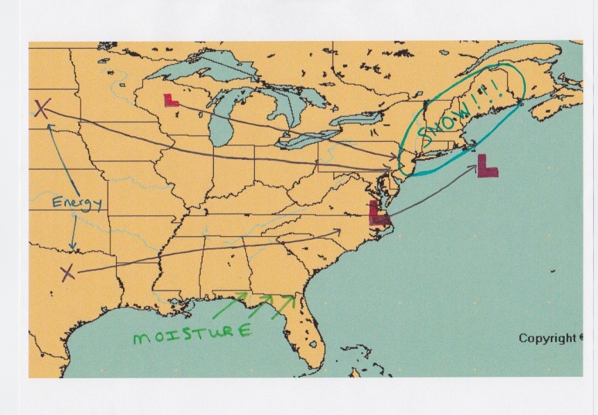
Below is my depiction of how this storm will play out. Two pieces of energy, marked by the X’s, are going to come together somewhere just south and east of the region. The X that is located over South Dakota is in charge of supplying the energy, while the X over Texas is in charge of supplying the moisture. And when these two come together (or phase) this will create a scenario that promotes rapid intensification of the surface cyclone off the Mid-Atlantic coastline. Or simply put, the storm is going to go boom.
As for a timeline on this system it is possible that light snows could begin as early as 8 am on Friday. Not much in the way in accumulations is expected at the beginning; but as the day progresses and we head towards the afternoon things should go downhill rather quick. It looks like the beginning of the heavy precipitation will be sometime between 3 and 5 pm. And from say 4 pm until sometime Saturday morning, possibly even until early afternoon we will be at the mercy of the storm. The storm slowly pulls away Saturday afternoon leaving a lot of snow in it’s wake.
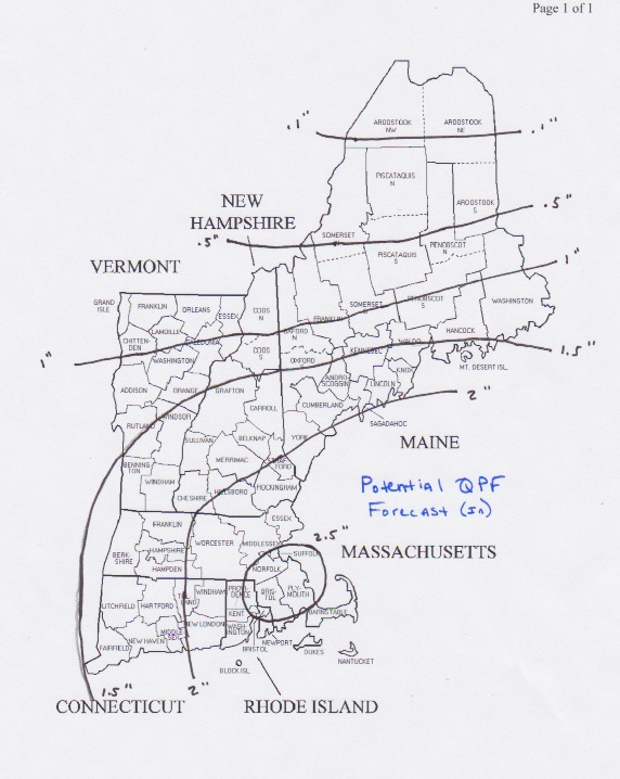
Now that we understand what is going to happen, it is time to tune some of the finer details. The first detail we need to figure out is how much liquid is going to fall from the sky. The numbers I have calculated below reflect my thoughts on how much liquid (not snow) we can expect. Contoured values are in inches. All of Southern New England receives 1.5″ of liquid with many locations receiving 2 inches or more.
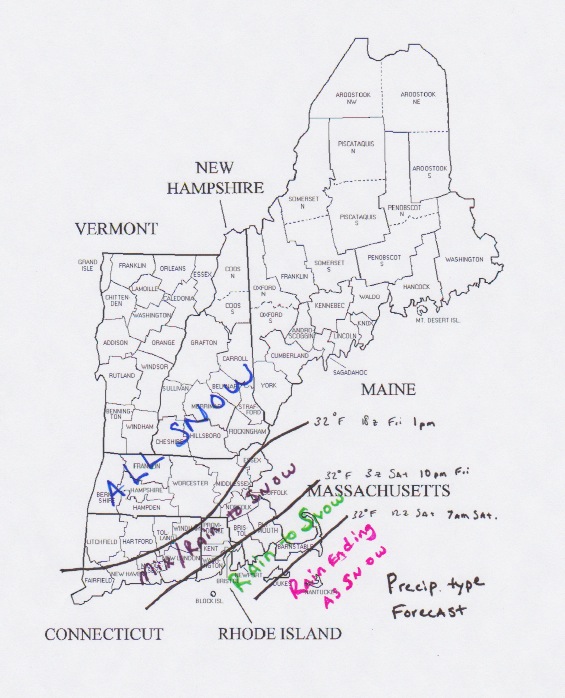
Next up we have to determine which locations will receive all snow, which locations could see rain to snow and which locations will see mostly rain. For this storm, it looks like everyone should see mostly snow. Places inside of the 128 belt might begin as a mix or rain Friday afternoon. But as precipitation rates increase and the storm strengthens, cold air should take over and everyone should go to snow. Except maybe the outer Cape.
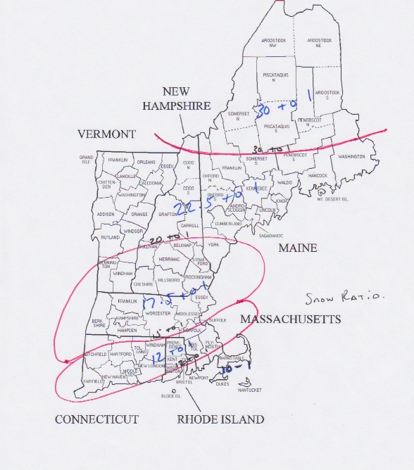
Ok so we have determined how much liquid we are going to get. We have figured out who gets snow/mix/rain. Now to determine how much snow actually falls. To do this we have to determine the snow ratio; that is how the amount of liquid relates to snow growth. This is determined by what the temperature is through the column of the atmosphere. This is very difficult to pin down and is often in correct. But I took a stab at it anyway. It is as follows.
We have total liquid. We have snow ratios. Now let’s calculate how much snow is going to fall. IMPORTANT: The following image is what I calculated, not what I am forecasting. That’s not to say that these numbers aren’t attainable. I am just having a hard time wrapping my head around them. And honestly I averaged out some areas meaning I should have put a plus sign in the 2 to 3 foot zone.
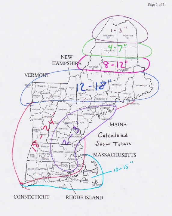
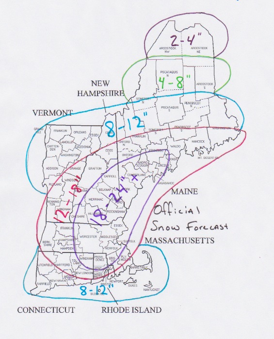
Normally the calculated snow totals are the numbers I run with. But this time I just can’t bring myself to do it because I can’t imagine a scenario where they come true. It is just too difficult to imagine. So I took a more rational approach and attempted to create a more realistic snow total map. Even though it is more realistic; it is still one that would go down in the record books.
There is one thing that I would change looking at my map now that I have uploaded it. I would add a plus sign to all zones, even the one that already has a plus sign.
For those of us who did not experience the Blizzard of ’78, this one has the chance to be the storm that we tell our kids and grandkids about. I honestly can’t remember a storm in my lifetime with the potential this one has. The evidence is overwhelming in favor of this storm, but I am still having a difficult time believing it.
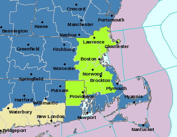
The National Weather Service at Taunton has issued a Blizzard Watch for most of the area. The areas in light green are under the Blizzard Watch. The dark blues are Winter Storm Watches. I fully expect the watch to be expanded to include the rest of the South Shore/Cape and possibly Worcester County. This means that conditions including winds greater than 35 mph, visibility less than .25 miles and obviously heavy snow are likely.
The time to make preparations is now. This storm is not only going to bring a lot of snow, but also the chance that it could knock out power to many. The combination of wind and snow can be a problem for trees and power lines. Stocking up on food and water is probably a good idea. I would recommend having all preparations accomplished by 1 pm on Friday.
Plow crews will likely having a very difficult time keeping up with this storm and the combination of snow and wind will create snow drifts in some locations that will be impossible to measure. This is a storm that has the potential to shut down the region for an extended period of time. PLEASE BE PREPARED.
I will have an update tomorrow afternoon. I am not expecting many changes in the guidance as it comes in leading up to the storm. I am confident in my forecast. I just worry that I might have underdone the snow totals.
Stay safe.
-Chris
