Remember in my last forecast when I issued a snow map for last weekend and I mentioned how I was lacking confidence? Well last weekend was a learning experience for myself. I learned that I should never issue a snow map that identifies deterministic snow totals when I do not have complete confidence in my forecast. That I should always air on the side of caution and remember that there is a reason for my lacking in confidence.
Last weekend was also an unfortunate in terms of timing. I issued my snow map late in the afternoon on Thursday. Up until that point there had been a rather good amount of agreement between the computer models in terms of the weekend snow forecast. But as I was creating my map, a few of the models came in with a scenario that did not agree with my forecast. Which led to me lacking confidence when I published the snow map. What was unfortunate was that Friday morning I went on a weekend trip to a location that did not have any wifi. Which is why I did not update everyone on the storm and why my final forecast prior to the event was so terrible.
But from every mistake something new is learned. And I have realized that every forecasting mistake I make is a blessing in disguise in that for some reason it becomes ingrained in my memory bank and I can draw on those mistakes to make a better forecast in the future.
Enough about last weekend though. How about this week ahead? Unfortunately it does not appear to be all that great. A storm system is going to track to our west and die. When it does a new system will form along the East Coast and track our direction. Right now it looks to be a mixed bag of precipitation. Possibly starting as snow, then transitioning to rain, while stopping at all other precipitation forms in between. Places could see freezing rain and sleet from this one. Truly a mixed bag of precipitation. Also, this storm system will run into an atmospheric wall so to speak and will be stuck over our heads for a few days. Giving New England the chance of a rain or snow shower from Wednesday through Saturday.
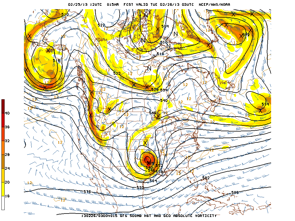
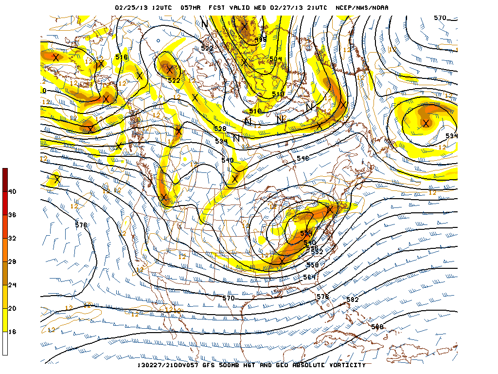
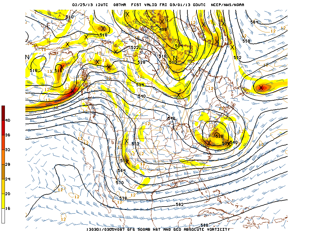
To give you a visual of what I am talking about I have selected the following three images. The images are from the GFS model and they are of 500 mb Heights & Vorticity. If you remember from some of our previous blogs that vorticity can be thought of as energy. It is the energy in the atmosphere that helps create upward vertical motion which is necessary for storm formation.
This first image is forecasted for tonight at 10 pm. The area of interest is the big ball of vorticity (shaded regions) in northwest Texas and southeast Oklahoma. Of importance is the closed height contours (black lines) surrounding the system. The system is no longer an open wave and is very near it’s peak intensity.
This forecasted image is for Wednesday afternoon at 4 pm. We can see that our storm system has really only drifted to the northeast to the Ohio River Valley. It is at this time that New England is in a favorable location for positive vorticity advection (upward motion) and we will most likely be getting rained on. Higher elevations could see snow.
This final image is forecasted for 10 pm Thursday night. Notice how the system is now centered over Southern New England. Also noticed how the shaded regions have decreased in intensity. Evidence that the system has slowly been dying. But also notice how that all of New England is surrounded by vorticity. This is why most of the forecast includes a chance of a snow or rain shower.
7 DAY FORECAST
Tuesday: Mostly cloudy with afternoon highs in the low 40s. North-northeast winds 5-10 mph.
Wednesday: Rain/snow moves in from southwest to northeast after midnight. This is a very tricky forecast. It will all depend on the northward push of warm air. If it gets far enough north, rain is likely. If it gets stopped and runs into a wall; then we could see all forms of precipitation from rain to snow to sleet to freezing rain. Highs around 40 with a north wind at 15-20 mph.
Thursday: Heaviest precipitation has moved away, but everyone still has a chance of a rain or snow shower. Highs in the mid 30s. Variable winds 10-15 mph.
Friday: Chance of a rain or snow shower in Eastern New England. Highs 35-40.
Saturday: Chance of a snow shower in the state of Maine. Partly to mostly cloudy elsewhere. Highs around 40.
Sunday: Weather continues to improve. Probably see the sun this day. Highs around 40.
Monday: Partly cloudy with highs around 35.
-Chris
So here is my very early, very crude and lacking a whole heck of a lot of confidence snow map.
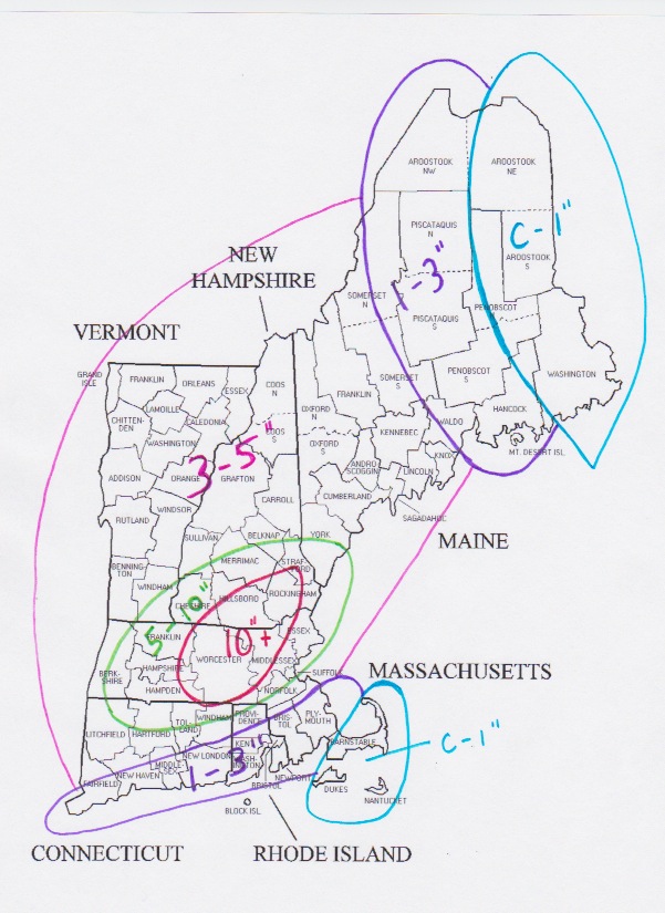
Our computer guidance models agree that there will be a storm this weekend. Impacting the region between the hours of 5 pm Saturday to 5 pm Sunday. Times are approximate.
What our computer models can not decide on is how the storm will play out. My above map is my educated guess at how the forecast will play out. BUT I would like to reserve the right to change the map drastically.
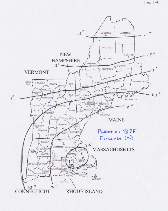
Although snow totals are low across Eastern and especially Southeastern New England, this is where I expect the most amount of water to fall. Only problem is that most of it will fall as either plain rain or sleet or a mix of snow & rain.
Hopefully by tomorrow morning this situation will be much more clear and I will be able to issue my snow map with more confidence.
-Chris
De ja vu anyone? For what will be the third weekend in a row, a significant coastal storm is progged to form off the East Coast of the United States. Here is what the last two looked like:
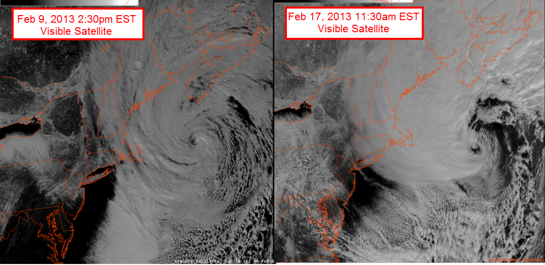
Whether or not this upcoming system ends up looking like these two is yet to be determined; but I will say this: this weekends storm has the potential to be a significant, if not major snow storm for Central & possibly Southern New England.
For a while now the pattern has supported the potential for a storm this coming weekend; but it wasn’t until last night’s run that they began to advertise a system with major impacts.
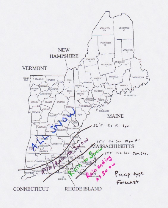
This morning’s runs have come in and they continue to show the idea of a big storm. One difference being that we will likely have to closely monitor a rain/snow line with this one; whereas the last two weekend storms were all snow.
Places that stay all snow however could be looking at 12″+ of heavy wet snow. Places that begin as rain could possibly see half an inch of rain; followed by 6″+ of snow.
As always, finer details such as specific amounts, rain/snow line location and other potential impacts are to be determined as we get closer to the event.
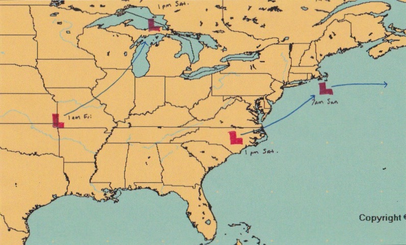
For a general overview of how this system will play out, see my handcrafted image below. The initial storm system will track from Oklahoma to the UP of Michigan where it will begin to die. While this is occurring, a new system will be forming near the Carolinas. This storm will then track northeast and pass very near to Nantucket.
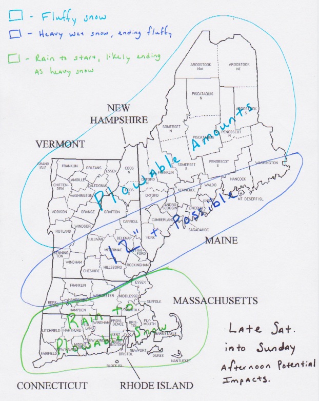
And as for a very early, very crude forecast for potential impacts here in New England; see map below.
Just wanted to give everyone a heads up that we look to make it 3 for 3 in the weekend snow storm department. And that this one also has the potential to significantly impact us.
-Chris
After last weekend’s Blizzard the last thing most New Englanders want is another big snow storm. Luckily this weekend’s storm looks to form just a little too far to the East. But Eastern portions of New England; especially Maine where Blizzard watches are up, looked to be clipped by this system.
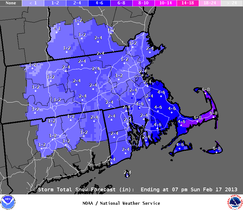
If you see snow flying this afternoon it should not be a surprise. We have a chance of light snow basically from now until tomorrow afternoon. Accumulations should be minimal at best. Tomorrow afternoon the big ocean system will make it’s closest pass to the region and could deliver a period of moderate snow. The further east one lives, the more potential snow they could see. For a perfect visual to this I have provided the National Weather Services snowfall forecast.
Not that extreme Southeastern Mass has a chance of around 4 inches of so and that Cape Cod could see 6″ or more.
After this snow on Sunday, we get a little bit of a break until Wednesday when a few snow showers appear possible. And as the pattern has shown, there is a chance of a weekend storm somewhere off the East Coast and this will have to be monitored going forward.
7 DAY FORECAST
Tonight: Light snow possible. Especially across far Eastern portions of New England. Overnight lows in the low 20s. Northwest winds 10-15 mph.
Sunday: Large Ocean storm passes us to the East. Should throw some moisture our direction. Accumulating snow likely across Eastern areas. Highs in the upper 20s. West-northwest winds 10-15 mph. Higher gusts likely on the Cape.
Monday: Partly cloudy with highs near 30. West wind 10-15 mph.
Tuesday: Partly cloudy with highs in the low 40s. Chance of a snow shower late afternoon. Southwest wind 5-10 mph.
Wednesday: Chance of light snow very early morning. Afternoon highs 35-40.
Thursday: Partly cloudy with afternoon highs 25-30.
Friday: Partly cloudy with afternoon highs in the low 30s.
-Chris
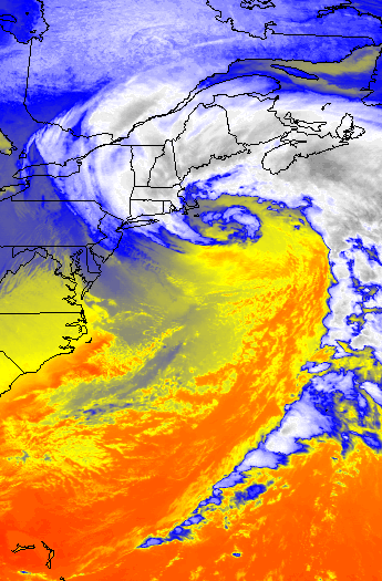
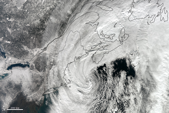
I just wanted to share a couple of my favorite images from the Blizzard of this past weekend. This storm is number 1 on my list for having the most impressive satellite images of any storm I have experienced to date.
Bringing a general 2 feet of snow to most; except central CT (where they got 3 feet), this one has gone down in the record books. The Blizzard of 2013 moved into the number 5 spot at Boston for most snow from a storm. While going down as number 1 at many locations such as Portland, ME and Hartford, CT.
But that storm is behind us now. On to the next one. Which will be here early Thursday morning. Luckily this one will not be big at all. In fact it will probably only affect those south of Boston. Places on the Cape could see a couple inches. While north of the canal might see a dusting to an inch.
After the next potential system is here for the weekend, but that is a big question mark right now!
7 DAY FORECAST
Tonight: Mostly clear with lows in the mid 20s. West wind around 10 mph.
Wednesday: Increasing afternoon clouds with highs in the low 40s. Light west winds 0-5 mph.
Thursday: Morning snow across extreme Southern New England. Only an inch or two really. Afternoon highs in the mid 40s. Light west winds 0-5 mph.
Friday: Partly cloudy with highs in the mid 40s.
Saturday: Chance snow shower. Otherwise mostly cloudy with highs in the low 40s.
Sunday: Looks like ocean storm should miss us to the south. Cold. Highs only in the mid 20s.
Monday: Partly cloudy with highs in the low 30s.
-Chris
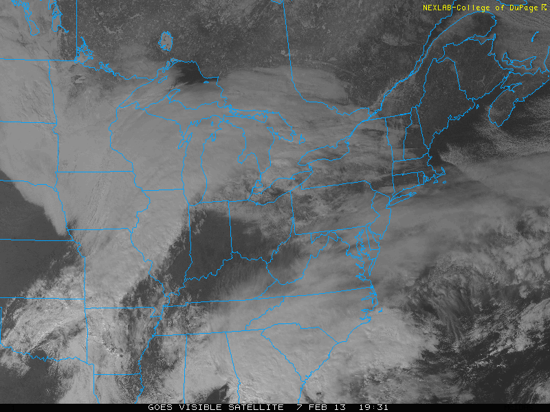
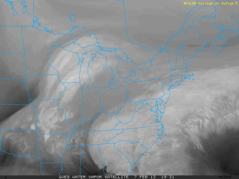
Another day has gone by and we are still on track to be impacted by a snowstorm the likes of which we have not seen in quite a while. The closer that we get to the storm the more and more the computer guidance is beginning to resemble the Blizzard of 1978. In fact from a meteorological stand point this storm could bring more snow and just as much wind as the 1978 edition brought.
Where do we stand right now? The following two images are visible and water vapor image stills of the Eastern U.S. Right now our storm is still in two pieces, but one can look at the image and just know that something big is about to occur.
What we have are two pieces of energy moving across the U.S. One piece is moving along the Polar Jet Stream and is located near eastern Iowa. The second piece is moving along the Subtropical Jet Stream and is just west of Atlanta.
It is these two pieces combining into one that will bring us our storm.
SYNOPTIC OVERVIEW:
Yesterday I outlined how the two pieces of energy were going to act and move across the country, but it can not hurt to do this again. Both pieces of energy are making a beeline for just off the New Jersey coast where they will come together and phase into one very intense storm.
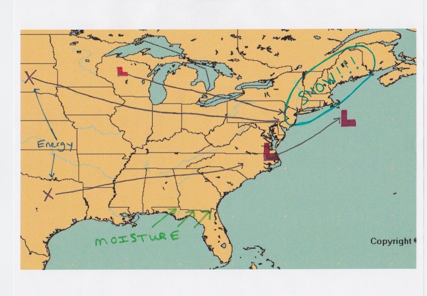
The image below is my attempt to illustrate how the two pieces of energy, marked by the X’s, will move and act over the next 3 days. Of importance to note is the loop that the storm performs just south of the Island of Nantucket.
When these two systems come together, they will spawn an intense storm. But this storm can only become so strong. When the system reaches it’s point of maximum intensity it undergoes what is known as occlusion. When this occurs the storm’s forward movement become almost non-existent. Giving way to the loop.
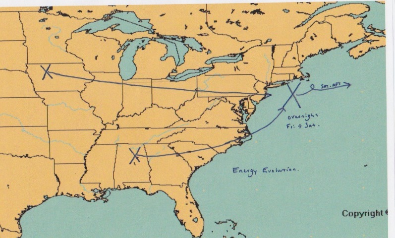
As for what I think the surface reflection is going to look like, that is as follows. Note the two storm systems combining into one off the Mid-Atlantic coast. Also note the loop that the storm performs south of Nantucket. As the upper level energy occludes, it will essentially reach out and grab the surface system. Slowing the low pressure’s movement and in fact possibly performing this loop.
This loop is important. The Blizzard of ’78 did this. This loop turns our storm from a 24 hour event into a 36 hour event. Just adding to the possible snow totals.
Also of importance is the area of High Pressure in southeastern Canada. This High is in a textbook location for getting our biggest snow storms. It does two things for us. It will slow the storm’s progress and it will supply the region with plenty of cold air. Put everything together and we have a lot of snow.
TIMELINE:
8 to 10 AM: Light snows overspread the region. Just enough to notice. Accumulations will be minimal.
1 to 3 PM: Snowfall increases in intensity. Snow accumulations are underway. A few inches are likely. I would advise that everyone be off the roads and home by 3 pm.
5 to 7 PM: Heavy snow moves in. Snowfall rates of 1 to 3 inches per hour. This is when we pick up our feet of snow. Accumulations will be measured in feet and not inches. The heaviest of the snow lasts from 7 pm until noon on Saturday (possibly a little longer)
Noon Saturday: Snow should begin to taper off. It might linger through the evening, but the major accumulations will be done by this time.
FORECAST:
So now that we have the synoptic overview and the timeline. Let’s complete the forecast. I will be honest, when I was making this forecast I was having trouble. Not because the forecast was that difficult, but because the forecast I was coming up with is almost impossible to believe. In fact, the forecast was fairly easy considering the amount of agreement in the guidance. It was the idea of forecasting snow totals of multiple feet that was the problem.
What I am trying to say is that it is not easy to put together a forecast for something that I have never seen before.
Yesterday we looked at the total amount of liquid precipitation I expected to fall from the sky. Well after another day of computer model runs I have recalculated that and it is as follows.
Now that we have the liquid forecast, we can turn this into a snowfall forecast. One that was giving me chills as I was making it because this type of snow map is one that I used to draw when I was a young child dreaming of the perfect snow storm.
As you can see I have almost all of New England receiving a foot or more of snow. Except for extreme northern Maine, this is going to be a significant to historic snow storm.
Please take this one seriously, I have not seen a storm with potential like this ………ever.
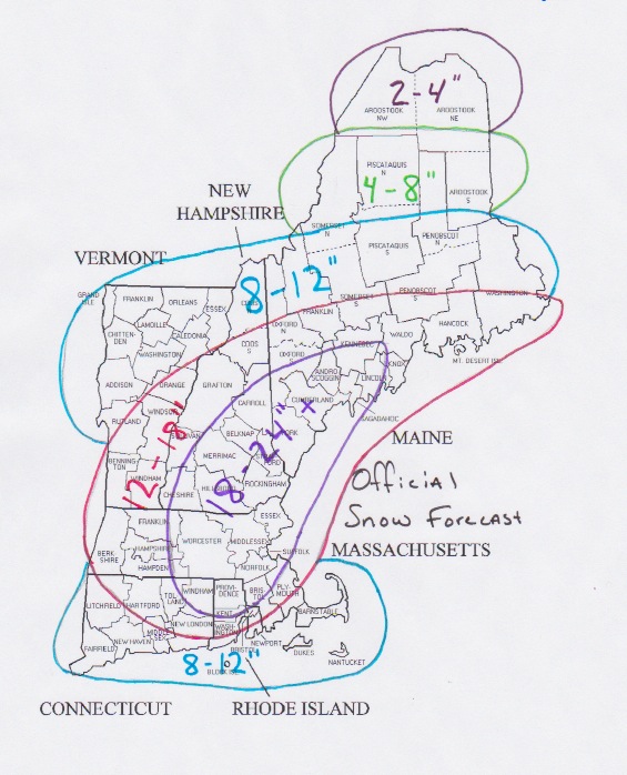
NATIONAL WEATHER SERVICE:
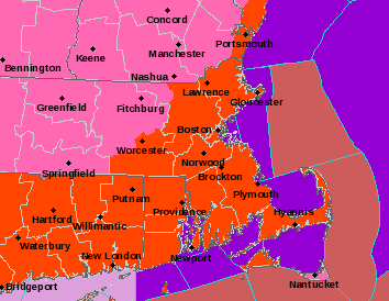
The following image is the from the NWS at Taunton. This is their warning map for our area. The bright orange colors are Blizzard Warnings. The pink area is Winter Storm Warnings. The green color that we can’t see is for a Coastal Flood Warning along all coastlines. The maroon color offshore is for a Hurricane Wind Warning. Or simply put, all of the strongest worded warnings that Taunton can use, they are.
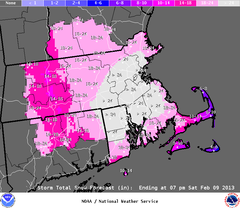
The following image is Taunton’s snowfall forecast. These are the guys that are getting paid for this so I figured I would show it to back up what I am saying.
OTHER IMPACTS……..like WIND:
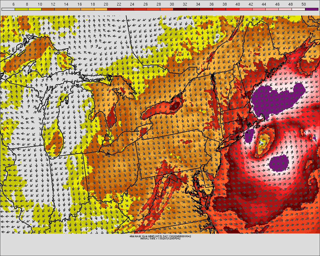
The winds generated from this system are going to be impressive. Sustained winds could be on the order of 30-40 mph. Gusts could be as high as 60 mph. Over the Cape and immediately coastline, hurricane force winds are possible. Meaning power outages are probable.
The following image is just one models depiction of what the winds could possibly look like. The whites and purples are pushing 60+ mph. The oranges and reds for everyone are 40+ mph. Blowing and drifting snow is a given. Blizzard conditions for all are likely.
THE OCEAN:
One of the impacts that not many people are touching on is the potential danger from waves and surge that our beaches are facing. In addition to possible wind damage, beaches and places near the water should worry about erosion from storm surge and massive waves. At it’s peak intensity, this system is going to mirror a hurricane. The combination of wind whipped waves and a storm surge on the order of 3 to 4 feet will take a toll on the beach and those near the beach. Places that tend to experience coastal flooding from our stronger storms should expect that to happen again. The time to prepare is now. Don’t wait until your first floor is under water to get out.
PREPARATIONS:
I know this is New England and I know that we are a hearty bunch, but this storm has the potential to be something that we haven’t seen since the Blizzard of 1978. And honestly from the meteorological perspective, if it happens as the computer guidance is showing it could be WORSE.
In terms of snow and wind this one could be as bad if not worse than the Blizzard of ’78, but in terms of societal impacts not so much. This time around we kind of know it is coming. That isn’t to say we need to take this lightly!!!
Everyone should be prepared for the worst of the possible outcomes. Yes this storm is going to drop a lot of snow, but it is also going to be very windy. The chance that many of us lose power does exist. And if that happens during the height of the storm then many of us can expect to be without power for a while. Which is why the time to take the necessary precautions is now!
Just a few thoughts on what everyone might want to do. Run to the grocery store. Stock up on: milk, bread, batteries, flashlights, food. Just a little tip, don’t worry about buying perishable goods. If the power goes out for a while, just open the door and stick it in the snow. Mother nature is giving you a natural freezer.
Other ideas that might come in handy. I would highly recommend that everyone start their snowblower now, before the snow starts to make sure that the machine is still working. Make sure it has gas and oil and anything else that it needs. I would also recommend putting it in a place that is pretty close to the door that you plan on walking through when you venture outside.
As for trying to get outside….I would bring a shovel inside the house. That way when 2 feet of snow fall and drifts of 4 feet or more bury your house in; you at least have some way of attacking the wall of snow.
I would advise everyone to fill up their vehicles with gas. In fact get some extra gas for the snowblower just in case. I would also advise every to have cash on them in case power goes out for a while.
This is going to be a good one. It can’t hurt to make all of the preparations just in case this comes in as bad as it looks like it might.
Enjoy this everyone. It isn’t everyday that we get something of this magnitude.
For a play by play of the storm(as long as I have power), follow me on twitter @Chrisrotary12.
-Chris
Yesterday I mentioned that some of our computer guidance models were advertising a significant coastal storm for our region on Friday. Well those computer models are still showing a storm and the ones that weren’t are now showing it as well.
In fact some of the output from the models has been down right scary and almost unbelievable. This morning the NAM put out almost 5 feet of snow for Southern New England. Now that is very unlikely, but cut those totals in half and we are still looking at 2 to 3 FEET of snow.
The model that has led the way with this system has been the European. It has shown a strong storm impacting us from as early as Sunday night I believe. It has been remarkably consistent this week and when considering it is statistically our most reliable model; it is hard to argue against. Seemingly all other guidance as moved into agreement with the European model; meaning that a significant storm is on it’s way.
In fact, if the computer models are correct in what they are currently thinking, this one has the potential to go down in the record books with such storms as the Blizzard of ’05, President’s Day 2003, the April Fools Day blizzard of 1997 and the Blizzard of ’78.
Even if the models are wrong in what they currently show, a significant storm is still incoming. Maybe we don’t reach as high as the storms mentioned above, but we are still looking at our first significant coastal storm since Halloween of 2011.
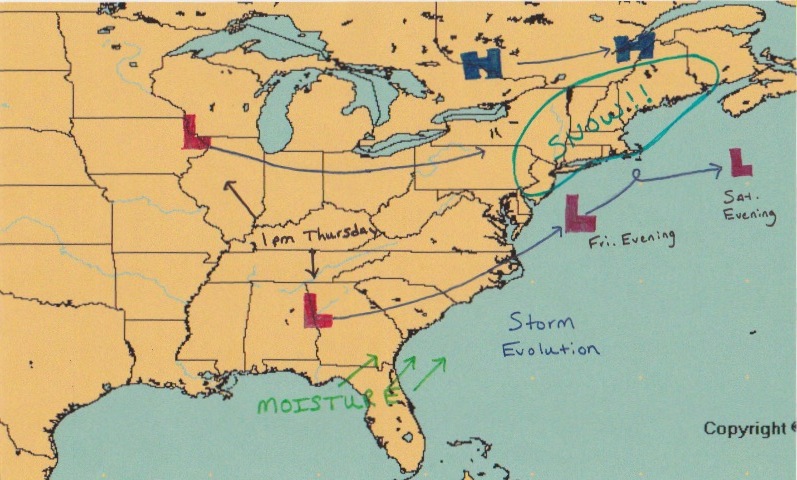
To show you what I have come up with I would like to walk you through how I make a forecast. First things first; one has to to understand the players involved and how these pieces will play out with time.
Below is my depiction of how this storm will play out. Two pieces of energy, marked by the X’s, are going to come together somewhere just south and east of the region. The X that is located over South Dakota is in charge of supplying the energy, while the X over Texas is in charge of supplying the moisture. And when these two come together (or phase) this will create a scenario that promotes rapid intensification of the surface cyclone off the Mid-Atlantic coastline. Or simply put, the storm is going to go boom.
As for a timeline on this system it is possible that light snows could begin as early as 8 am on Friday. Not much in the way in accumulations is expected at the beginning; but as the day progresses and we head towards the afternoon things should go downhill rather quick. It looks like the beginning of the heavy precipitation will be sometime between 3 and 5 pm. And from say 4 pm until sometime Saturday morning, possibly even until early afternoon we will be at the mercy of the storm. The storm slowly pulls away Saturday afternoon leaving a lot of snow in it’s wake.
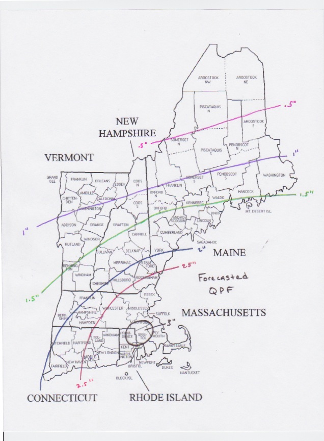
Now that we understand what is going to happen, it is time to tune some of the finer details. The first detail we need to figure out is how much liquid is going to fall from the sky. The numbers I have calculated below reflect my thoughts on how much liquid (not snow) we can expect. Contoured values are in inches. All of Southern New England receives 1.5″ of liquid with many locations receiving 2 inches or more.
Next up we have to determine which locations will receive all snow, which locations could see rain to snow and which locations will see mostly rain. For this storm, it looks like everyone should see mostly snow. Places inside of the 128 belt might begin as a mix or rain Friday afternoon. But as precipitation rates increase and the storm strengthens, cold air should take over and everyone should go to snow. Except maybe the outer Cape.
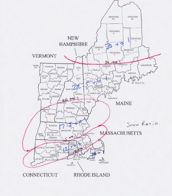
Ok so we have determined how much liquid we are going to get. We have figured out who gets snow/mix/rain. Now to determine how much snow actually falls. To do this we have to determine the snow ratio; that is how the amount of liquid relates to snow growth. This is determined by what the temperature is through the column of the atmosphere. This is very difficult to pin down and is often in correct. But I took a stab at it anyway. It is as follows.
We have total liquid. We have snow ratios. Now let’s calculate how much snow is going to fall. IMPORTANT: The following image is what I calculated, not what I am forecasting. That’s not to say that these numbers aren’t attainable. I am just having a hard time wrapping my head around them. And honestly I averaged out some areas meaning I should have put a plus sign in the 2 to 3 foot zone.
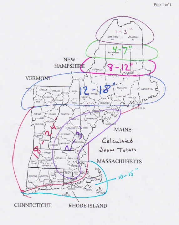
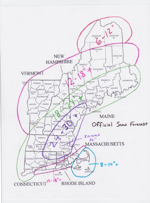
Normally the calculated snow totals are the numbers I run with. But this time I just can’t bring myself to do it because I can’t imagine a scenario where they come true. It is just too difficult to imagine. So I took a more rational approach and attempted to create a more realistic snow total map. Even though it is more realistic; it is still one that would go down in the record books.
There is one thing that I would change looking at my map now that I have uploaded it. I would add a plus sign to all zones, even the one that already has a plus sign.
For those of us who did not experience the Blizzard of ’78, this one has the chance to be the storm that we tell our kids and grandkids about. I honestly can’t remember a storm in my lifetime with the potential this one has. The evidence is overwhelming in favor of this storm, but I am still having a difficult time believing it.
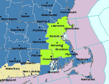
The National Weather Service at Taunton has issued a Blizzard Watch for most of the area. The areas in light green are under the Blizzard Watch. The dark blues are Winter Storm Watches. I fully expect the watch to be expanded to include the rest of the South Shore/Cape and possibly Worcester County. This means that conditions including winds greater than 35 mph, visibility less than .25 miles and obviously heavy snow are likely.
The time to make preparations is now. This storm is not only going to bring a lot of snow, but also the chance that it could knock out power to many. The combination of wind and snow can be a problem for trees and power lines. Stocking up on food and water is probably a good idea. I would recommend having all preparations accomplished by 1 pm on Friday.
Plow crews will likely having a very difficult time keeping up with this storm and the combination of snow and wind will create snow drifts in some locations that will be impossible to measure. This is a storm that has the potential to shut down the region for an extended period of time. PLEASE BE PREPARED.
I will have an update tomorrow afternoon. I am not expecting many changes in the guidance as it comes in leading up to the storm. I am confident in my forecast. I just worry that I might have underdone the snow totals.
Stay safe.
-Chris
So we meteorologists have been keeping this a secret for the last couple of days, but one of our computer models has been advertising a major snow storm for New England. The model that has been doing this is the European Model; which statistically speaking is our most accurate model. For the last couple of days, the Euro was all by itself in thinking a major storm was coming. But overnight the American model; the GFS, trended toward the European. And finally this morning came in with an almost exact match to the Euro.
So it time to show everyone what the Euro has been showing me. This morning’s run of the Euro is the most extreme run we have seen. So I will show you the important images that you need to see. Outlining what the worst (or best) possible outcome is.
Each image that follows will have the description of what it means above it.
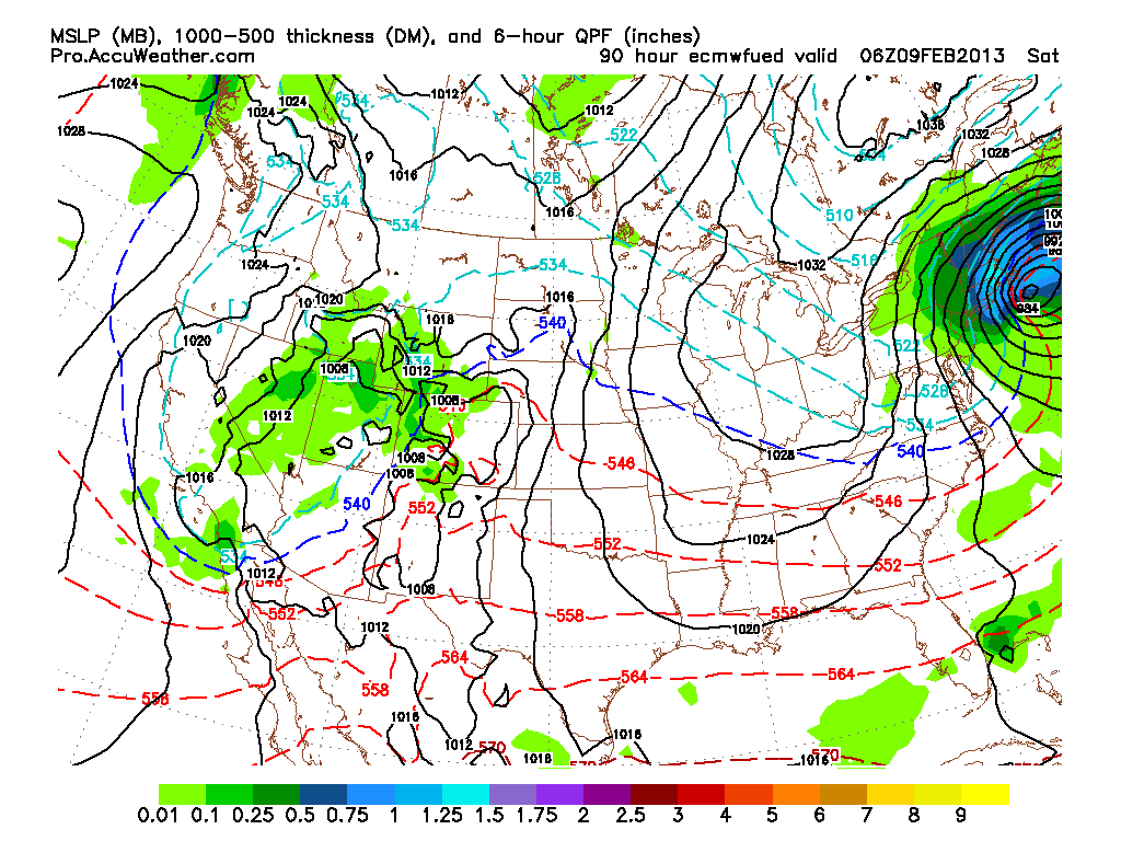
First image is the surface reflection of what our storm could look like at 1 pm on Friday. The green shading is potential precipitation in inches for the previous 6 hours. The dark blue shading is .5″. Or potentially 5 inches of snow in 6 hours.
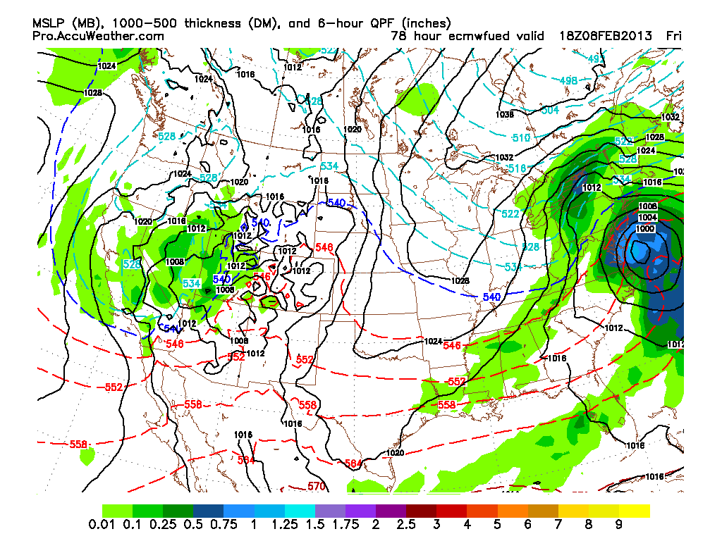
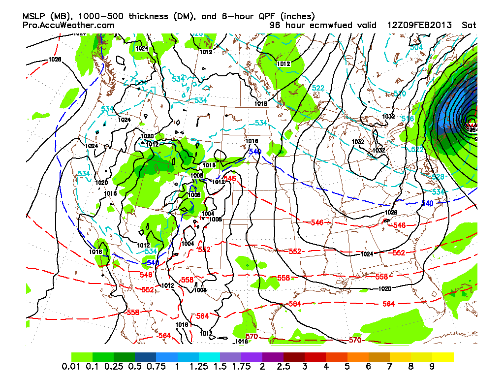
The next image is what our storm could look like at 7 pm Friday Evening.
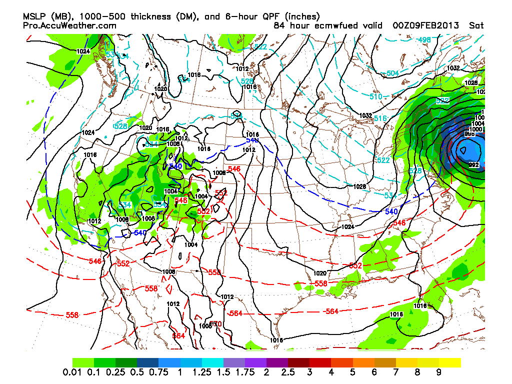
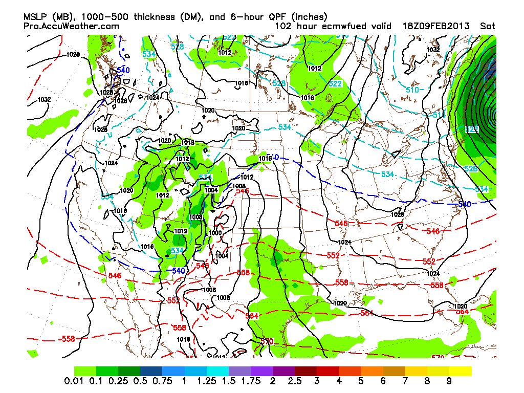
Our possible storm at 1 am Saturday morning. The light blue over eastern Mass is 1.25″ of precip or more in 6 hours…….12″+!!!!
Our storm at 7 am Saturday. Still going strong.
Storm at 1 pm Saturday. Finally moving away.
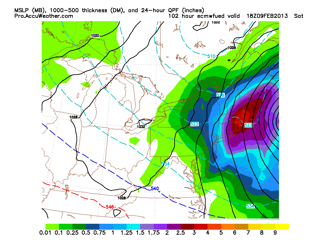
Total liquid that falls out of sky based on the European model. Majority of Eastern Mass sees over 3″ of liquid…….or possibly over 30″ of snow.
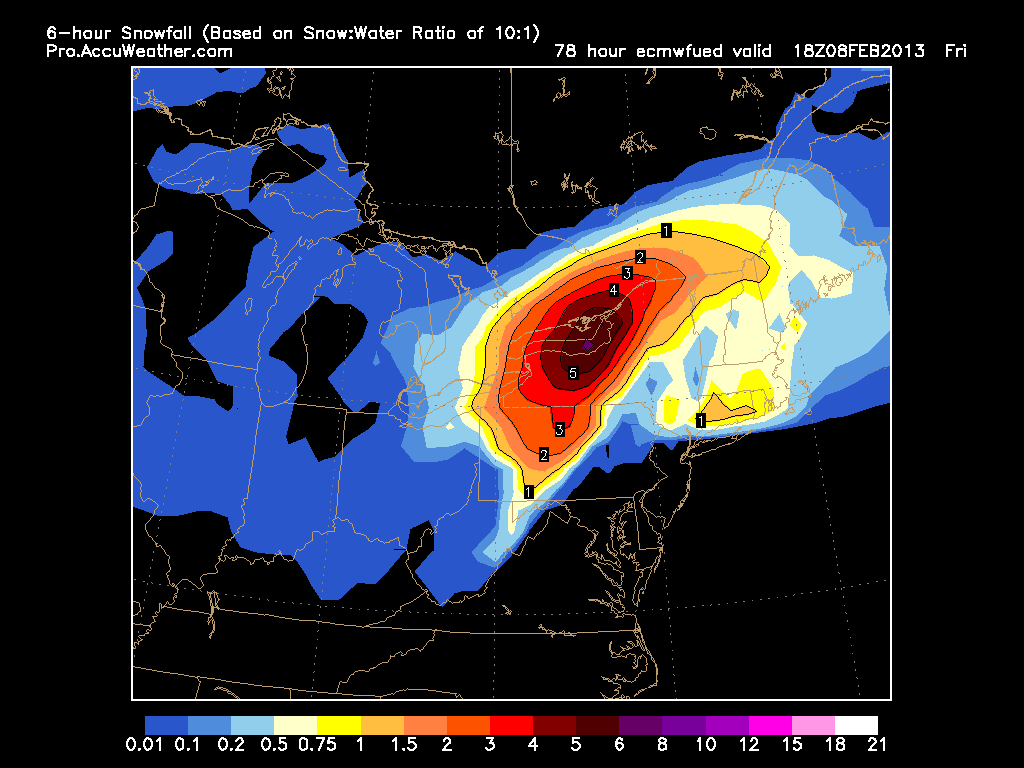
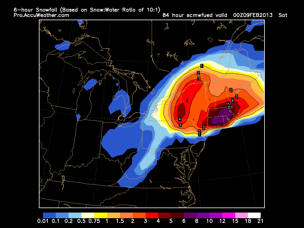
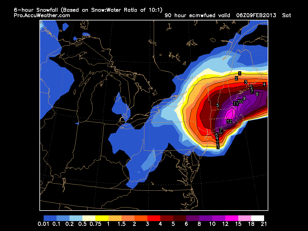
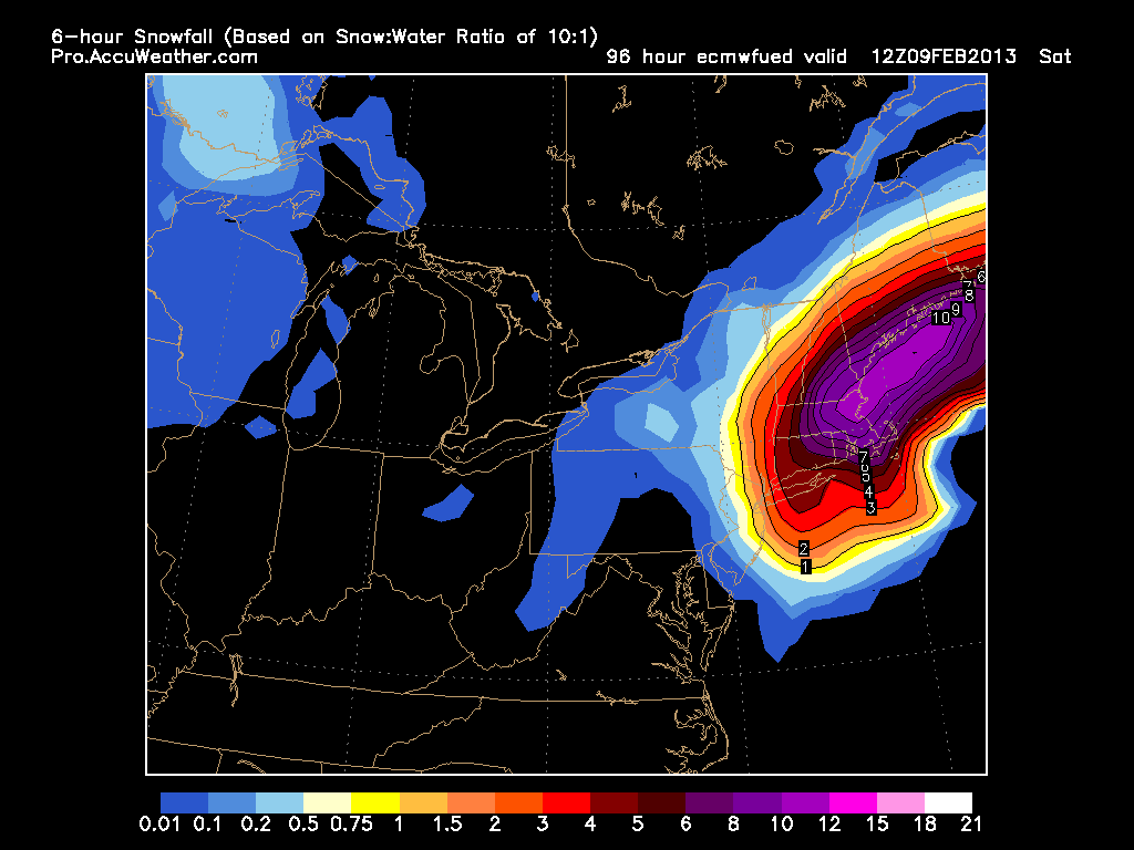
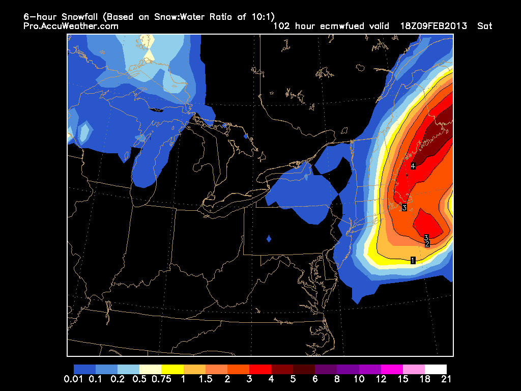
The next set of images is the amount of snow that falls in the previous 6 hours based on the model and a 10 to 1 ratio.
First image is from 1 pm Friday. Storm just moving in.
7 pm Friday night. Storm starting to crank. 1″ per hour snows.
1 am Saturday. Full on blizzard. 2″ per hour snows. Possibly over 12″ in 6 hours. Insane!
7 am Saturday. Storm still going. Beginning to pull away.
1 pm Saturday. Storm pulling away.
Finally the total amount of snow for entire storm. Based on 10 to 1 ratio. 24″+ for most with 30″+ for a good chunk. Would be one for the record books.
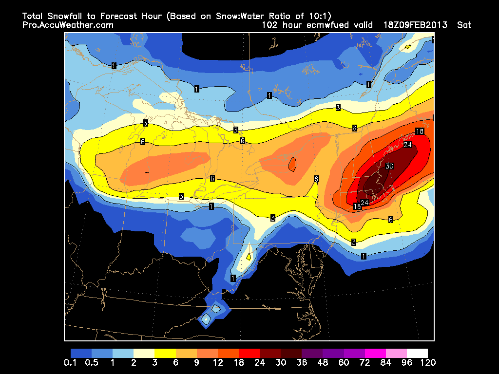
Reminder that this is most likely the most extreme scenario we could possibly see……..I think. We are still 3 days away so a lot will change, but I just wanted to show everyone what I have been seeing for the last two days.
Fitting that the anniversary of the Blizzard of ’78 is tomorrow. More to come tomorrow as things become more clear.
-Chris
This is getting out of hand isn’t it? Most locations have more snow than last year, but I bet most can not remember a single storm we have had. The best system we have had this year was on the 29th of December. It is now February! January was just terrible! Time to move on. Thunderstorm season in New England is coming up right?
After barely any snow in January, February looks to start the same. This upcoming week three storm systems are forecasted to form off the Eastern U.S. coast; but not a single one appears to be close enough to give New England any significant snowfall. But like always, things will continue to be monitored going forward. And I will update everyone as necessary.
The weather has been so boring, that I can barely bring myself to update this blog on a more frequent basis. Getting tired of rambling on about how progressive the flow is and how storm systems are passing us by. These storm systems that have been missing us have gone on to form some very strong and substantial Ocean storms for the North Atlantic. So it isn’t like the storms aren’t there; they are just missing us.
This week will be much of the same. Temperatures will be either side of 30 most days and storm systems on Sunday, Tuesday and next weekend look to miss us to the East.
Since we have so much time and nothing fun or interesting to forecast, I would love it if someone or everyone would leave a comment on something that they would like to learn about. Seems like it is time for me to start filling my education section of this blog. So hit me with anything and I will do my best to explain it in clear and understandable terms.
7 DAY FORECAST
Tonight: Partly cloudy skies with overnight lows in the teens. West winds 5-10 mph.
Saturday: Mostly cloudy with highs around 30. Southwest winds 10-15 mph.
Sunday: Chance of snow across Eastern regions. Mainly just flurries if anything. Outer Cape might pull off any inch or two. Highs in the low 30s. Northeast wind 5-10 mph.
Monday: Partly cloudy with highs 30-35. West winds 10-20 mph.
Tuesday: Day starts clear or partly cloudy. Clouds overspread the area throughout the day as storm passes to our southeast. Highs in the upper 20s.
Wednesday: Mostly cloudy with highs in the low 30s.
Thursday: Mostly clear with highs in the upper 30s to near 40.
Friday: Mostly cloudy with highs in the low 40s.
-Chris
