So we finally get some cold air in here, but we can’t buy a snowstorm. And one of the reasons for lack of storms is partially due to the cold air. Confusing right?
Weather systems (like our snowstorms) feed off of temperature gradients. The East Coast of the North American Continent is a perfect feeding ground for storms. With the continent being cold and the Atlantic Ocean being relatively warm; this creates a temperature gradient that fuels storms. But right now, we are too cold and the temperature gradient that a storm likes is too far to our south. In fact there have been a string of rather impressive systems exploding just to our east. Leaving us weather weenies watching with long faces as storms move away.
Enough with the misery that I am suffering through. Back to the weather forecasting bit. This weekend will feature lots of sunshine, but not a whole heck of warmth. Though it will likely feel warm considering the temperatures we just went through. Weekend highs will be in the 20s.
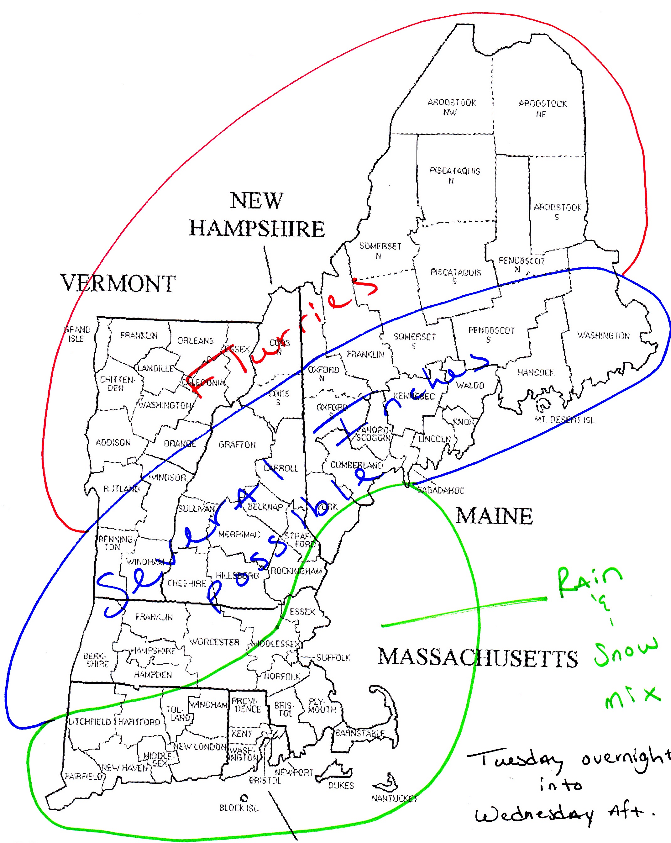
Heading into the beginning of the work week, temperatures will continue to moderate; rising steadily each day through Wednesday. Unfortunately, the beginning of the work week looks rather unsettled. Beginning with a bit of snow Monday night. Right now accumulations of around 3 inches look possible. Will adjust as necessary.
Overnight Tuesday in Northern New England should be a showery one and it even looks as if it will be rain showers for most. A storm system looks to track to our west, putting the region on the warm side of things. During the day Wednesday rain looks to over spread Southern New England; possibly heavy at times. The system should move out by morning on Thursday, where it could possibly end as a bit of light snow in spots.
7 DAY FORECAST
Today: Bright sunshine. Cold. Highs around 20. Blustery conditions at times. NW winds 15-20 mph.
Tonight: Clear and cold. Lows 5-10. WNW winds 5-10 mph.
Sunday: Mostly clear. Warmer. Highs 25-30. Winds NW 10-15.
Monday: Increasing clouds throughout the day. Snow moves in during the evening from west to east. Only light accumulations expected. Afternoon highs in the mid 30s.
Tuesday: Snow moves out just before the morning commute. Highs in the low 40s. Rain showers move in across Northern New England during the evening.
Wednesday: Showers continue in Northern New England. Steady rain moves into Southern New England and continues through the night. Afternoon highs 45-50.
Thursday: Increasing sunshine as storm moves away. Highs in the mid to upper 30s.
Friday: Outside chance of snow. Highs in the low 30s.
-Chris
Kind of chilly out right now huh? Arctic air from Canada has invaded our region, but luckily it will be on it’s way out. One more very cold night ahead before temperatures moderate a bit.
Tomorrow night we have a chance of some snow flurries. A system is diving down out of the Great Lakes and will dive south of the region where it will strengthen rapidly off the East Coast. Unfortunately for us, this storm will be too far to our South to give us any substantial snowfall. Most locations should expect light snow resulting in a coating to an inch at most. Extreme Southern regions like the Cape and Islands can expect an inch or two.
The system will be gone by Saturday morning meaning that the weekend should be fairly nice; except for the afternoon highs in the 20s part. Early next week will feature warmer temperature for most; Northern New England will still be frigid, but Southern New England will see temperatures return to near or slightly above average (around 40).
Near the end of the forecast period; Wednesday and Thursday appear to be unsettled as a system might track to our west and bring us some rainy weather. But as the front passes, the rain might possibly change over and end as some snow. But that is a long ways off and details are likely to change.
7 DAY FORECAST
Tonight: We are under a wind chill advisory! Which means it is COLD! Overnight lows 0-5. West wind 10-15 mph.
Friday: Partly cloudy. Highs around 20. Snow moves in overnight. Flurries for most. Possibly and inch further south. West wind 5-10 mph.
Saturday: Mostly clear. Highs in the low 20s. Northwest wind 10-15 mph.
Sunday: Clear. Highs in the upper 20s. Northwest wind 10-15 mph.
Monday: Increasing clouds. Highs 35-40. Precipitation moves in after dark, but moves out again before dawn.
Tuesday: Mostly cloudy. Highs in the low 40s.
Wednesday: Precipitation moves in during the early morning hours and lasts throughout the day. Precipitation looks to be rainy and scattered in nature. Highs 40-45.
Thursday: Chance of a shower. Highs around 40.
-Chris
Now that I am over the disaster that was the Patriots game yesterday I suppose I will dive into the topic of snow. It seems as if all of us can expect a little light snow early Tuesday morning and into the day Tuesday.
I would like to apologize for not having a groovy snowfall map, but I am working off a new laptop and snowfall maps will be back soon.
Generally I am expecting a light snowfall for most, but a small portion of the region could possibly see much more. What is known as a Norlun trough might possibly set up over a small portion of the region. (For more on what a Norlun trough is the following is from Matt Noyes: Norlun) If the trough does develop as it could, then this region will receive a higher total of snow than the average.
Right now my educated guess is that this region that might receive enhanced snow is extreme Southwestern Maine, Southern New Hampshire, and Northeastern Massachusetts and the outer Cape. This region could be looking at as much as 6″ or more of snow.
But for the rest of the region snow totals will decrease from East to West. With 2-4″ of snow likely between Boston and Worcester; and 1-2″ of snow from Worcester on west.
Good news about this snow is that it should be of the fluffy variety as temperatures will be plenty cold to support a fluffier type of snow. Which will be easier to brush away. But we will have to brush it away quickly as our next storm moves in sometime Friday evening. This storm is a question mark right now, but will have to be monitored. This one could possibly bring widespread warning criteria (6+”) to a large portion of the region.
7 DAY FORECAST
Today: Partly cloudy with highs in the upper 20s. West wind 5-10 mph.
Tonight: Clouds move in and light snow breaks out across the region. Generally around 3″ for most. Higher amounts in the locals mentioned above. Overnight lows in the upper teens. Variable winds 0-5 mph.
Tuesday: Early morning bursts of snow throughout the region coming to an end during the afternoon. Highest amounts along the coastline. Afternoon highs in the mid 20s. Westerly winds around 10 mph.
Wednesday: Partly cloudy skies with VERY cold temperatures. Highs in the teens.
Thursday: VERY cold again. Highs in the teens.
Friday: Mostly cloudy. Potential for another snow storm moving in during the afternoon and evening. This one has potential, but as always, everything is subject to change. Afternoon highs 15-20.
Saturday: Chance for morning snow. Highs around 20.
Sunday: Partly cloudy and cold. Highs in the low 20s.
-Chris
I will admit that I have been asleep at the wheel recently. But that is what happens when the weather is all in all pretty boring! The last 2+ weeks have brought nothing but mostly dry conditions and slightly above average temperatures.
These slightly above temperatures caused all of our snow to melt, which released a lot of moisture into the atmosphere. This moisture was trapped in the lower levels due to high pressure overhead. The combination of abundant moisture, high pressure and light winds is what led to the outbreak of fog across most of Southern New England.
Finally today the sun was able to break through and temperatures soared. This has been a possibility for the last few days, but we were never able to get the sun to make an appearance. Today it did and look what happened. Thankfully this is not going to last and winter will be returning soon.
Computer guidance has trended northward fairly significantly with a plume of moisture that is gathering across the Southeast today. Look for this batch of precipitation to arrive overnight Tuesday and Wednesday sometime after 1 am. It will stick with us through the Wednesday morning commute and depart sometime after lunch.
As it appears right now, it will begin as snow in most communities due to the timing of very early morning onset of snowfall. As the sun comes up I am expecting for a rain/snow line to push northward and advance as far as possibly the CT/MA border and stretch east through Eastern Mass.
All locations can expect a coating, but those places that stay all snow could see a few inches. I’m hesitant to go too high on snow amounts due to the uncertainty around this system. Remember this system has only been on the radar for what seems like a few hours. And there are questions to how far north the precipitation extends.
Will feel much more confident in amounts after this evenings guidance comes in. With likely a more detailed snow map coming tomorrow morning. Stayed tuned.
7 DAY FORECAST
Tonight: Partly cloudy skies with overnight lows in the lower 30s.
Tuesday: Mostly clear. Chance of a sprinkle along the South Coast. Highs in the low 40s.
Wednesday: Precipitation moves in sometime very early during the morning hours. Starts as snow in most locals. Several inches possibly where it stays all snow. Daytime highs 30-35.
Thursday: Mostly cloudy. Highs in the low 30s.
Friday: Partly cloudy and cold! Highs in the upper 20s.
Saturday: Partly cloudy with highs around 40.
Sunday: Mostly clear with highs around 40.
Monday: Partly cloudy with highs around 40.
-Chris
Well the boring, but cold week that we just endured went out with a couple flurries this morning. Just Enough to notice in the air. Sadly, this coming week will be more of the same; only a bit warmer.
Flow across the North American Continent is decidedly split at the moment with the Polar Jet Stream residing up in Canada and the Sub-Tropical Jet Stream staying well to our south. Which is why we have had such dry and boring weather around these parts.
This looks to continue through the first half of the week and it isn’t until possibly Friday that we may have a chance at something. But that in itself if going to be a big question mark because it is so far out in time and we will have to monitor the area of High Pressure we will be under to see just how stubburn of a feature it is going to be.
But looking past this 7 day forecast, things are slowly looking up in terms of winter returning to our region. As we head towards the second half of January things should become a little more active and we should begin to see our chances of snow on the rise.
As for now, look for the dry weather we have had to continue as temperatures begin to moderate slightly above normal. Don’t expect any high temperatures near 50 like some were advertising earlier, but temperatures in the upper 30s and low 40s are still above normal for this time of year.
7 DAY FORECAST
Sunday Night: Partly cloudy with lows in the mid to upper 20s. Chance of a flurry in Southern New England; snow shower or two up north. West wind at 5-10 mph.
Monday: Mostly clear with highs in the upper 30s; possibly touching 40. Variable winds 0-5 mph.
Tuesday: Mostly clear except for some high clouds. Highs around 40. Southwest wind 5-10 mph.
Wednesday: Partly cloudy with highs in the low to mid 40s. South wind 5-10 mph.
Thursday: Mostly clear with highs in the upper 30s to near 40.
Friday: Becoming mostly cloudy with a chance of rain. Does not look impressive right now. High pressure might be too stubburn. Highs in the upper 30s.
Saturday: Mostly cloudy with highs 40-45.
Sunday: Mostly cloudy with highs in the mid 40s.
-Chris
