After last night’s cold front pushed south of the region things have certainly changed a little bit. Today is going to be quite cold with highs that will struggle to reach 35. But that is not going to last.
Last night’s cold front did not go very far away. It is currently located just off the south coast in the vicinity of Long Island. Eventually this front is going to turn around and come north as a warm front after a piece of upper level energy goes by. When this happens we will be in for a warm up. Sunday through Tuesday could very well all feature highs in the mid 50s with Monday looking like the warmest day.
As for any precipitation during the forecast, there are no big synoptic storms for the next 7 days, but there are a couple of chances of showers. All in all not a bad forecast for the first week of December.
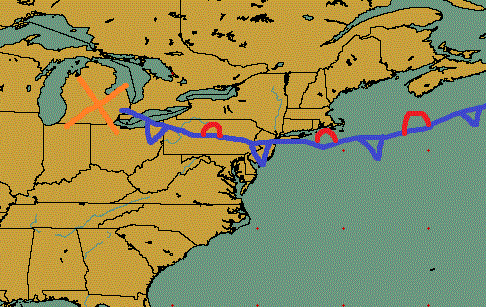
The image above is to give you an idea of what happening at the present time. Last night’s cold front dropped south of the region and has essentially come to a stop; which makes it a stationary front. The big orange X over Michigan represents a piece of upper level energy. This energy is going to travel along the frontal boundary and out to sea. It is the reason for increasing clouds this afternoon.
The next image below is to show why the beginning of next week is going to be rather warm. After the piece of energy exits stage right, a new storm system is going to push north through the Great Lakes. In doing so it is going to turn our old cold front into a warm front and push it back north of our region. Allowing for southerly flow to take over and allowing for warmer temperatures to move in. This is why Sunday through Tuesday could very well feature highs in the mid 50s.

7 Day Forecast
Today: Cold. Increasing clouds throughout the day. Highs only in the low to mid 30s. North wind 5-10 mph.
Tonight: Mostly cloudy and chilly. Overnight lows in the upper 20s. East-northeast wind 5-10 mph.
Saturday: Looking like an excellent day for Superbowl Saturday in Mass. Extremely isolated chance of a shower. More like an isolated chance of drizzle or flurries. Highs in the low to mid 40s. East-southeast wind 10-15 mph.
Sunday: Warm. Highs in the mid 50s. Chance of an overnight rain shower. South wind 10-15 mph.
Monday: Best day of forecast. “Hot”. Afternoon highs in the mid to upper 50s. Someone in western New England could squeeze out a 60 reading. Southwest wind 5-10 mph.
Tuesday: Last day for warmth. Better chance of finding a 60 reading in western New England than Monday. Highs in the mid to upper 50s away from the coast. Near 50 at coast. Increase in afternoon clouds likely.
Wednesday: Morning rain showers; possibly ending as afternoon/evening snow showers. Highs in the upper 50s.
Thursday: Partly cloudy. Highs 35-40.
-Chris
