After last night’s cold front pushed south of the region things have certainly changed a little bit. Today is going to be quite cold with highs that will struggle to reach 35. But that is not going to last.
Last night’s cold front did not go very far away. It is currently located just off the south coast in the vicinity of Long Island. Eventually this front is going to turn around and come north as a warm front after a piece of upper level energy goes by. When this happens we will be in for a warm up. Sunday through Tuesday could very well all feature highs in the mid 50s with Monday looking like the warmest day.
As for any precipitation during the forecast, there are no big synoptic storms for the next 7 days, but there are a couple of chances of showers. All in all not a bad forecast for the first week of December.
The image above is to give you an idea of what happening at the present time. Last night’s cold front dropped south of the region and has essentially come to a stop; which makes it a stationary front. The big orange X over Michigan represents a piece of upper level energy. This energy is going to travel along the frontal boundary and out to sea. It is the reason for increasing clouds this afternoon.
The next image below is to show why the beginning of next week is going to be rather warm. After the piece of energy exits stage right, a new storm system is going to push north through the Great Lakes. In doing so it is going to turn our old cold front into a warm front and push it back north of our region. Allowing for southerly flow to take over and allowing for warmer temperatures to move in. This is why Sunday through Tuesday could very well feature highs in the mid 50s.

7 Day Forecast
Today: Cold. Increasing clouds throughout the day. Highs only in the low to mid 30s. North wind 5-10 mph.
Tonight: Mostly cloudy and chilly. Overnight lows in the upper 20s. East-northeast wind 5-10 mph.
Saturday: Looking like an excellent day for Superbowl Saturday in Mass. Extremely isolated chance of a shower. More like an isolated chance of drizzle or flurries. Highs in the low to mid 40s. East-southeast wind 10-15 mph.
Sunday: Warm. Highs in the mid 50s. Chance of an overnight rain shower. South wind 10-15 mph.
Monday: Best day of forecast. “Hot”. Afternoon highs in the mid to upper 50s. Someone in western New England could squeeze out a 60 reading. Southwest wind 5-10 mph.
Tuesday: Last day for warmth. Better chance of finding a 60 reading in western New England than Monday. Highs in the mid to upper 50s away from the coast. Near 50 at coast. Increase in afternoon clouds likely.
Wednesday: Morning rain showers; possibly ending as afternoon/evening snow showers. Highs in the upper 50s.
Thursday: Partly cloudy. Highs 35-40.
-Chris
O.k. time for a little honesty. I have been delaying this blog for probably close to 3 days now. And the reason for the delay is simply that I had no clue what was going to happen with the potential storm for Tuesday. For what has seemed like the last 2 weeks we have been targeting the Tuesday/Wednesday time frame for a potential system to impact New England. And for the longest time it appeared that this system would pass to our northwest and bring us rain. Well just as I was ready to type this blog and forecast rain for Southern New England the computer guidance decided to completely change it’s mind and bring the system south of New England……giving us the chance at snow.
And for the last couple days now, the computer guidance has been flip flopping with either idea, but finally it appears that some form of a consensus is being found. It looks as if most of Southern New England has a chance at seeing some flakes fly Tuesday afternoon and evening; but with only places say…..south of the Mass Pike having a chance of accumulating snowfall.

Image above is a very crude description of what should happen. The orange X over the Dakota’s represents a piece of energy. This piece of energy is going to drop down through the Midwest where a low pressure center should begin to form near the Ohio River Valley. This low pressure should track to the east and out into the Atlantic; giving locations on the northern side a chance at some light snow. Places in the lighter blue have a chance at seeing flakes fly, while places in the darker blue have a chance at seeing accumulating snow. Of course with everything in the world of weather prediction there is the chance that this could change and it probably will.
But first, it’s going to be cold today, temperatures will struggle to reach 40 as we experience our coldest air mass of the season after yesterday’s cold front. Tonight will be clear and cold. As evidenced by the last few times we have had clear & dry nights, our temperatures will be allowed to fall fairly far. Lows around 20 would not be a surprise.
Another clear day on Monday before we deal with our small storm on Tuesday. Followed by a fairly cold air mass to end the work week. Then it isn’t until Saturday that we see our next chance of a storm.
Looking ahead into December, after a brief warm up during the first week it appears that the overall atmospheric pattern is going to be conducive for cold to drop down out of Canada and for potential storms to impact our region. It certainly looks as if the month of December is shaping up to be an interesting one; hopefully things can pan out and we can see some good snow storms.
7 Day Forecast
Today: Partly to mostly cloudy. Cold. Highs in the upper 30s to around 40.
Tonight: Clear and cold. Lows in the lower 20s.
Monday: Partly cloudy; with increasing clouds in the afternoon. Highs in the low to mid 40s.
Tuesday: Mostly cloudy and dry to start. Light snow and flurries over take the region during the afternoon and into the night. Mainly a south coast storm. Accumulations of only a couple of inches. Highs in the low 40s.
Wednesday: Storm exits to the east. Departing clouds. Highs in the low 40s.
Thursday: Partly cloudy. Cooler. Highs around 40.
Friday: Partly cloudy and cold. Highs only in the mid 30s.
Saturday: Isolated chance of a shower/snow shower as of right now. Highs again only in the mid 30s.
-Chris
Looking across our region today, clouds are moving in from the southeast. These clouds are associated with a developing area of low pressure off the Carolina coast. This storm is the one that I mentioned a while back that could be a nuissance for Thanksgiving. But thanks to a rather strong area of high pressure overhead, the storm will be kept to our south. The only thing that we will have to deal with is the clouds.
Sadly though, even as we get rid of the clouds from the offshore storm, more clouds will move in from the west and keep our skies mostly cloudy for Tuesday and Wednesday. Looking back to our west there is a weak surface feature that is causing nothing but a cover of clouds that stretch from Canada to Texas. This feature (and associated clouds) will be here for Tuesday and Wednesday.
As for what is going to happen with the storm that is forming off of the Carolina’s, it will stay away from our region. The area of high pressure we have been under will keep the storm to our south. Again the only effects we feel from the storm are clouds and a constant northeasterly fetch off the water. As our high pressure system pushes to the east, it will prevent the storm from moving out into the Atlantic, so it is possible that the storm will sit and spin somewhere between Bermuda and the East Coast for a couple days. But again, just clouds and a northeast wind direction. Eventually this northeast wind direction will effect our temperatures; keeping them a little bit cooler than they would be otherwise. Most likely for the day on Wednesday.
Thanksgiving Day will be great!!!! Will be a wonderful day to go catch a High School football game and then go home and enjoy some turkey. Skies will be partly cloudy and temperatures will be in the low 50s. Can’t get any better……..well it could snow right?
Black Friday looks even better than Thanksgiving Day Thursday. Highs around 55 with partly cloudy skies. Is this the last week of November?
This weekend though looks a little questionable. There will be a system moving in from the west. This will spark off some showers and snow showers for our region. The upper level energy with this system could be quite potent meaning that some of the snow showers could really be snow squalls. Time frame looks like it could be late Saturday afternoon through Sunday morning. Will have to watch this develop moving forward. I know I wouldn’t mind a good snow squall.
7 Day Forecast
Tonight: Mostly cloudy. Highs clouds from low pressure off the Carolina’s is invading our atmosphere. Cloud cover will prevent it from getting as cold as the last couple of nights have been. Overnight lows around 30. Northeast winds 0-5 mph.
Tuesday: Mostly cloudy. An extremely weak surface feature that is currently only producing clouds will move in from the west. Afternoon highs in the upper 40s to near 50. Northeast winds at 5-10 mph.
Wednesday: Mostly cloudy. Consistent northeast winds will hold our temperatures down. Highs in the upper 40s. Northeast winds 10-15 mph.
Thursday: Partly cloudy. Highs in the low 50s. North winds 10-15 mph.
Friday: Partly cloudy. Highs around 55.
Saturday: Becoming mostly cloudy. An upper level piece of energy and a cold front are moving through giving us a chance of a rain/snow shower or possible a snow squall. Temperatures reach into the low 50s before the cold front moves through.
Sunday: Isolated snow shower or squall. Much colder. Quite windy…..some gusts as high as 40 mph. Highs in the low 40s.
-Chris
Last post I talked about how the week of Thanksgiving was one that looked like a stormy one. I talked about how the atmospheric pattern was going to change from a tranquil one into one that could feature storms for us in New England. Well I was incorrect……..sorta.
I have found that the computer guidance we Meteorologists use has a tendency to correctly predict a change in the atmospheric pattern, but it does not correctly predict the time frame of that pattern change. I am finding that computer guidance tends to overdue this change and tends to want to perform this change in pattern before the atmosphere is ready for it to occur.
So what did I just say? I was incorrect in thinking that the week of Thanksgiving will be a stormy one. But I still believe that I was correct in predicting that a change in pattern is coming. It is only going to be delayed until after Thanksgiving, perhaps even into December. The European community runs a computer model that runs a forecast for a month. The latest run of this product is showing that weeks 3 and 4 of this forecast are going to be cold ones here in the Northeast as air from Canada is allowed to drop into our region.
Is this set in stone to happen? Of course not!! But it does coincide with the atmospheric pattern turning more favorable for storms here in New England. Which means that as we head into December, we could be looking at a cold and stormy pattern here in New England. Which could of course mean snow.
But enough about what could happen a couple weeks from now. What about this week? Well this week is going to be boring. High pressure is in control and will remain in control through the week. The storm that I talked about last time is still going to form, just a little bit too far out to sea for us to feel its effects.
7 Day Forecast
Today: Big area of High Pressure centered along the Canadian Border. Lots of sunshine. Highs in the upper 40s to near 50. North-northwest wind at 5-10 mph.
Tonight: High pressure still in control. Nice clear, cold night. Clear skies allow for temperatures to drop into the upper 20s. North wind 0-5 mph.
Sunday: High pressure slides just a bit to the east, but weather is still perfect. A few high clouds likely to move in during the afternoon. Highs around 45. Variable winds 0-5 mph.
Monday: The High Pressure begins to weaken, but weather is still great. Partly cloudy skies with highs near 50. Light winds 0-5 mph.
Tuesday: The High has weakened and slid to the northeast. An area of low pressure is developing off the East Coast, sending some clouds our way. But the storm will stay offshore. Highs in the low to mid 50s.
Wednesday: Mostly cloudy, but rain stays offshore. Low pressure slowly moves off to the northeast away from the coast. Highs in the low 50s.
Thursday: Another area of high pressure, this one centered over the Ohio River Valley does just enough to keep us dry. Afternoon highs 50-55.
Friday: Chance of an isolated shower as a cold front swings through the Great Lakes. Warmer with highs 55-60.
-Chris
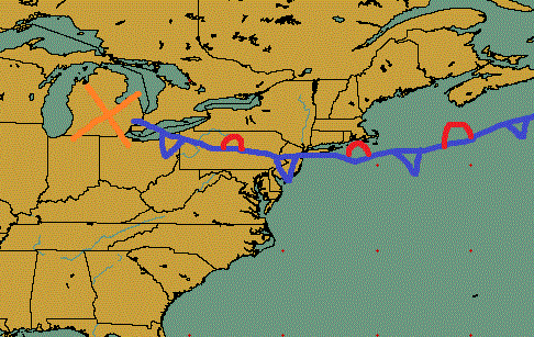
At the time of this post (evening on the 13th) a very strong cold front is traversing the region. This is the same cold front that brought record snows to Montana, severe storms to Minnesota and at times allowed it to be warmer in parts of Alaska than parts of Texas!! As this front continues to push offshore high pressure will assume command of our weather for the next few days. We all like images so I created one to illustrate what is currently occurring.

The cold front will continue it’s march off the East Coast this evening; taking with it all of the clouds and showers and making way for the general wind direction to turn to be out of the northwest. This will allow much cooler and drier air from Canada to enter the region. This cooler and drier air is symbolized by the very large area of high pressure centered around the Great Lakes.
This area of high pressure will be our weather for the next 5 days or so. We can expect lots of sunshine and more reasonable temperatures for the month of November.
7 Day Forecast
Tonight: Cold front pushes offshore. Skies clear and cooler temperatures move in. Winds shift to the northwest allowing Canadian air to move in. Overnight lows in the lower 30s.
Wednesday: Clear skies as high pressure is in total control. Highs slightly above 45.
Thursday: High pressure is still in control. Afternoon highs around 45.
Friday – Sunday: Partly cloudy skies with highs ranging from 45 to 50.
Monday: Chance of an isolated shower. Highs around 50.
Extended Forecast:
I teased it in the title of this post, but there appears to be stormy days on the horizon. The longer range computer models continue to advertise a system forming off of the East Coast sometime around mid-week for the week of Thanksgiving. A similar pattern to the one that allowed both Sandy and the nor’easter that followed appears to be making a return.
In the Meteorology community there are a number of devised products called teleconnections that have been created to help describe the large scale pattern in the atmosphere. These teleconnections and subsiquent large scale patterns tend to produce somewhat repeatable results and are helpful when it comes to forecasting. Here in New England, possibly the most important teleconnector for our weather pattern is called the North Atlantic Oscillation or simply, the NAO.
The NAO deals with the interaction of two large scale, semi-permanent features over the Northern Atlantic. These two features are the Icelandic low and the Azores High. The value of the NAO depends on the strength of these two features. If the two features are strong, then the NAO is said to be positive, but if they are weak, then it is said that the NAO is negative.
For a more detailed explanation of the NAO, go here.
The pattern that allowed Sandy and the nor’easter to impact us was one that featured a negative NAO value. It is this negative value of the NAO that promotes blocking in the atmosphere over the North Atlantic ocean. When this blocking pattern forms, storm systems are allowed to curl up the East Coast and impact New England.
Well looking ahead to the time frame of next week, it looks like a negative NAO is going to make a return.

The above image is the Ensemble forecast from the GFS forecasting model and it shows that all of the members dip below zero sometime around the 17th and stay negative through at least Thanksgiving. The GFS isn’t the only longer range model predicting the NAO value to become zero. The ECMWF is also forecasting for this value to become negative around the same time frame. Looking below at the column on the far right, we can see that the value of the NAO is very near zero by hour 162 (day 7) and is below zero by hour 192 (day 8). This negative value of the NAO combined with the continued advertisement of a storm system by the computer guidance give me the confidence that a storm system is going to form off the East Coast sometime next week. How close it comes to New England is the question to be answered at a later date.
 2012111312z ECMWF RUN NAO Values
 NAO value for forecast hour 000:  115.784065
 NAO value for forecast hour 024:  89.1970596
 NAO value for forecast hour 048:  134.995956
 NAO value for forecast hour 072:  140.430328
 NAO value for forecast hour 096:  164.703491
 NAO value for forecast hour 120:  146.786713
 NAO value for forecast hour 144:  69.299469
 NAO value for forecast hour 168:  0.320800781
 NAO value for forecast hour 192: -78.2510376
 NAO value for forecast hour 216: -100.020218
 NAO value for forecast hour 240: -108.136703
 NAO value for Day 1-5:  135.222717
 NAO value for Day 6-10: -43.3575363

-Chris
After the last two weeks brought a Hurricane and Nor’easter to New England, better days do lie ahead. The strong blocking pattern in the atmosphere that allowed for Hurricane Sandy and the nor’easter to impact New England has finally broken down allowing for a more typical pattern to take hold for the coming week.
Speaking of the nor’easter, many of us across the region saw our first snowfall of the season and in many places the storm overproduced in terms of the amount of snow that fell. For a great explanation for why many forecasts were incorrect, the image below is from the National Weather Service in Taunton.

The feature that the NWS highlights is the Coastal Front. It is a mesoscale feature that is found in a lot of our New England winter storms. Simply put it can be thought of as the all important rain/snow line. It is the battleground between cold air to the northwest and warm air to the southeast. To the northwest of this coastal front feature, the area of highest precipitation is often found. Which gives credence to the reasoning behind the area of 4-6″ of snow fell just to the northeast of the city of Providence.
This forecasting mistake is a perfect example for why I want to study the Coastal Front with my thesis research. I want to investigate the dynamics of this feature and try to devise a way to more accurately forecast it as a way to create more accurate snowfall total maps.
But for now this nor’easter and snowfall are behind us. Looking forward we have much warmer and more enjoyable weather for those who like “boring” weather.
As our last storm moves away from us our general wind direction will become more westerly and eventually southwesterly in nature. Allowing for warmer air to make its way into our region as we bask in the sunshine provided by a ridge of high pressure. Temperatures will reach there peak on Monday around 65 degrees. And even after a cold front moves through overnight Tuesday into Wednesday, temperatures won’t drop off too badly and will remain in the upper 40s to near 50.
7 Day Forecast
Friday Night: Mostly clear and cool. Great night for star gazing. Lows in the lower 30s.
Saturday: Increasing afternoon clouds with highs around 50.
Sunday: Yesterday’s increasing clouds bring the chance of showers or snow showers to Central and Northern NH & VT. Highs in the upper 50s.
Monday: Isolated clouds. Warm. Afternoon highs near 65. Couldn’t have asked for a better day to have off from school or work.
Tuesday: Chance of rain begins around dawn ahead of an approaching cold front. Daytime highs 50-55.
Wednesday: Rain exits before dawn as cold front passes through the region. Highs near 50.
Thursday: Partly cloudy. Highs 45-50.
Have a good weekend.
-Chris
Boy what looked like a pretty simple forecast has quickly turned into a fairly difficult one. The computer guidance over the last few runs has been trending towards the south and east with our storm. Meaning that there is a better chance that many of us start as snow before switching over to rain.
But the real trouble arises when we try to figure out who starts as snow and how long does it take for the snow to change to rain!!!
What do we know for sure?
Currently our storm is taking shape over the Carolina’s (see image below), moving to the ENE offshore. Offshore is where our storm will begin to intensify and it is here where it will phase with a piece of energy from the Polar Jet Stream (which is the dark shaded area over Missouri). This phasing of the jets will allow for a fairly strong storm to develop. (As a precaution, the National Weather Service at Tuanton has issued a High Wind Watch for all coastal communities along with Bristol and Plymouth Counties.)

We also know that this will be a particularly long duration event as precipitation looks to begin falling sometime after supper on Wednesday lasting through the day Thursday and wrapping up possibly overnight Thursday night.
But who will see some snow? Who will see all rain? Who could see a mixed bag of everything?
Right now I believe that everyone outside of 495 will START as snow, but with time the temperature will slowly rise and we will turn over to rain for most. Those who live in the higher elevations furthest away from the coast; western Worcester Hills and Berkshire could potentially stay all snow. Those who stay all snow could be looking at 2-3″ possibly. Those of us who start as snow can expect a coating at most.
One thing that we will have to watch for (and I believe this will happen) is that as we change from snow to rain there will be a time of freezing rain or sleet. Reason for this is that the mid-levels of the atmosphere are forecast to warm before the surface does. Let me explain: Precipitation high up in the clouds starts as snow crystals. As it falls it will remain as snow until the temperature rises above 32 F. When it does, the snow crystal will begin to melt becoming a water droplet, where it will usually reach the ground as rain. But there could be a time period where the ground is still below freezing, while the atmosphere is above freezing. When this occurs, the snow flake that has melted does not have enough time to turn back into snow. It either freezes enough to become sleet or it reaches the ground as a rain droplet and freezes on contact.
Again I expect there to be a small window where we will either see freezing rain or sleet, meaning that the roads and sidewalks could be a little slippery during this time frame. Hopefully, this window will not occur during the morning commute, but there is always the chance that it will.
We all love pictures right, so here is my crudely drawn map of what the precipitation forecast could look like.

It’s pretty simple actually. Places that stay all snow could get as much as 3 inches. Places that fall in the mix category should look to start as snow (a coating for the lower elevations, possibly an inch or two in the Worcester Hills) but transition from snow to sleet/freezing rain to all rain. And obviously those in the rain category will be all rain.
Again I would like to remind everyone that this will be a strong nor’easter and that winds at times could be quite strong. We are looking at sustained winds of 20-30 mph with gusts as high as 50 mph inland; 60 at the coast, so scattered power outages (especially near the coastline) are possible.
One final remark…….we can only hope that this is the pattern that carries us through the winter. (If you like snow)
-Chris
Now that Hurricane Sandy is behind us, it is time to look ahead. And it isn’t long until the next storm system is headed our way. The same pattern that allowed Sandy to make her way up the coast is still in place and this time it will spawn a nor’easter for the middle and second half of next week. As it stands right now this one looks like potentially more than our run of the mill nor’easter; this one could be quite strong. Reason being is that the two branches of the jet stream; the polar and subtropical branches, look to come together and phase off the East Coast. It is when this phasing occurs that we get our strongest nor’easters.
To illustrate what I mean by the two separate jet streams phasing together I have included the two following images. The first image is when the two jets are separate. I have marked the area of interest in the subtropical jet with a 1 and the area of interest in the polar jet as a 2. The second image is after the phasing process has occurred. There is no longer 2 separate jets, but 1 combined jet off the East Coast; meaning that there is one formidable storm there as well.


Right now it appears that rain could begin falling as early as supper time on Wednesday evening. This system is by no means going to be a quick mover. The blocking that caused Sandy make a quick left hook is still in place; meaning that the storms escape root to the northeast is going to be impeded. It looks like we may not be able to completely wash ourselves of this system until sometime Friday afternoon.
By Thursday morning, we will be completely engulfed by the effects of this nor’easter. The image below is for 7 am on Thursday from the ECMWF model.

The center of low pressure is located off the Jersey Coast (meaning more bad news for the already battered New Jersey beaches) and we here in southern New England will be dealing with a rather cold and windy rain. As the storm slowly moves to the northeast, it should be able to draw in some colder air from Canada and some of the higher terrains could see some snow out of this one. It doesn’t look like those of us below a few thousand feet will see any flakes, but if this changes I’ll keep you informed.
Another piece of this storm that isn’t what we want to hear is that the winds and wind gusts that are possible are quite strong. Right now it looks like winds could be as high as 25-30 mph, but with gusts as high as 60 mph possibly. Not what we want to hear after what we went through last week.
Below is my crudely drawn depiction of what I think is going to happen. The big L that I have drawn if for 7 am on Tuesday. The first long arrow up the coast is the storms track through 7 am Thursday. After that, the storm should slowly drift away from us, in a general east or northeast manner. Regions to the east of the green line are where places should expect some form of precipitation.

-Chris
