Even after the tropical downpours from what was left of Isaac left our region, we are still stuck with the tropical-like environment in its wake. You have probably noticed, but it is HUMID outside!! Temperatures are only running in the mid 70s, but the dew points are in the mid 60s as well. Making for a very humid environment. What we need to get rid of this air mass is a Cold Front; which is on the way for Saturday Night. But before we are able to experience the cool refreshing air that comes with a Cold Frontal passage, our temperatures and dew points are going to increase. Reason being is that the wind direction ahead of a Cold Front is from the south or southwest; which for us is generally a warm and humid wind direction. So for Friday and Saturday temperatures will be in the low 80s and dew points will be on the rise into the low 70s. Or simply put: HUMID!!! Finally after the front passes offshore early Sunday morning, our wind direction will switch around to out of the northwest and bring with it cooler and drier conditions.
As for how Saturday into Sunday is going to break down, it is as follows:
2 pm: The Cold Front should be located in Central NY State and heavy downpours and thunderstorms will have developed along it. Some storms could be strong. For our region; temperatures will be in the low 80s and dew points will be in the low 70s. This kind of air mass is a fairly unstable one. Which means that if any rogue storms fire ahead of the main line, then they could be quite strong as well.
8 pm: The Cold Front will be located around the MA/NY border and into Southern VT and through Northern NH. Showers and storms will continue to exist right along the front. Some may still be strong. As we lose solar insolation (sunlight), thunderstorm activity should begin to decrease in intensity, but not completely cease to exist. Places further east of the main line will still be fairly unstable, so again any pop up storms ahead of the main batch could be strong.
Overnight: Cold Front moves across New England. Bringing with it heavy rain and embedded thunder. 1-2″ of rain is possible; and as always, higher amounts can not be ruled out in isolated thunderstorms.
Sunday Morning: Cold Front pushes offshore and any left over rain moves away as well. All rain should be gone by noon or a little after. Giving way to a cooler more comfortable air mass; especially for Monday and Tuesday.
7 DAY FORECAST
Tonight: Chance of a shower and storm for Western and Northern New England as storms in New York State move east with time. Patches of fog should develop as we head towards morning. Overnight lows in the upper 60s.
Friday: Fog to start giving way to mostly cloudy conditions. Chance of a scattered shower for most of Southern New England; best chance lies back in Northern Connecticut and Western Mass. Daytime highs in the mid 80s.
Friday Night: Areas of fog develop again. Mostly cloudy skies. Lows in the upper 60s.
Saturday: Warm and HUMID. Morning fog burns off as we watch a Cold Front approach us from the west. Most of the day should be dry for us. Shower and thunderstorm activity should begin to increase around supper time. Rain and storms will last throughout the night. Highs in the low 80s.
Sunday: Morning showers and downpours come to an end as the Cold Front pushed off shore. Very comfortable air mass on the way behind the front. Highs around 75.
Monday: Beautiful. Fall like feel to the air. Highs around 70.
Tuesday: Repeat of Monday. Highs in the upper 60s to near 70.
Wednesday: Warmer. Highs in the mid 70s.
Thursday: Warmer still ahead of our next system. Highs in the upper 70s.
Tropics:
Orange: Amazingly this area of showers and thunderstorms that moved into the Gulf from the Southeastern States is a piece of energy from what was Hurricane Isaac. Given a 40% chance of development by the National Hurricane Center, this disturbance will receive a new name if it does in deed develop into a named system.
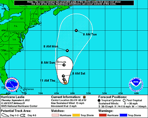
Formed from a wave that moved off the African Continent, Hurricane Leslie has been with us for some time now. Leslie is a large system that has been nearly stationary south of Bermuda for a few days. The steering currents around Leslie are very weak, therefore she has not moved much. Eventually though, she will be picked up and will begin to accelerate to the north; impacted the Island of Bermuda as a Hurricane. From there she will continue to accelerate north and will make a pass very close to Newfoundland Canada.
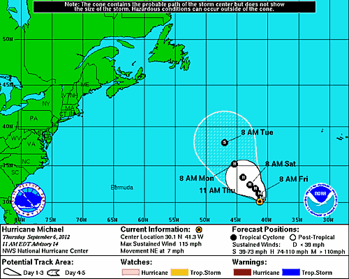
Michael is the first Hurricane of the 2012 season to be categorized as a major Hurricane with wind speeds of 115 mph; making him a Category 3 storm. Michael is very far away and is no threat to us and is no threat to any land for about the next week. But he is a good looking cyclone, so here is a satellite still of Michael. 
-Chris


