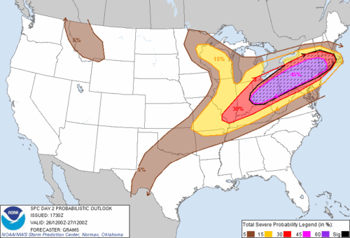
Well this is certainly something that we don’t see very often. The Storm Prediction Center (SPC) has put portions of Southern New England (SNE) under a “moderate” risk in their day 2 outlook. The first image shows the location that all of Southern New England is under a “Slight” risk, while western CT and SW MA are in the “moderate” threat region. The second image shows SPC’s Probabilistic forecast. All of SNE is being given a 15% chance of severe weather, but most of SNE is being given a 30% chance with some portions receiving a 45% chance. In addition, SPC has added the hatching in with the shading. What this means is that they are highlighting these areas for increased potential. So basically, all of SNE has an increased potential for severe weather tomorrow.
The following is taken directly from the SPC’s latest Day 2 outlook:
A RELATIVELY NARROW CORRIDOR OF ENHANCED TORNADO RISK SHOULD DEVELOP
ALONG THE WARM FRONTAL ZONE WHERE EFFECTIVE SRH AND STRONGEST
DEEP-LAYER SHEAR WILL BE MAXIMIZED. ALTHOUGH PINPOINTING THIS
CORRIDOR IS DIFFICULT GIVEN LIKELIHOOD OF PRECEDING OVERNIGHT
CONVECTION…IT APPEARS MOST PROBABLE FROM PARTS OF NY INTO SRN NEW
ENGLAND. SOME CONVECTION-ALLOWING GUIDANCE SUGGESTS THAT DISCRETE
CONVECTION MAY FORM WITHIN A PERSISTING WAA REGIME THU AFTERNOON.
What the above statement from SPC says in simple terms is this: Where ever the warm front ends up tomorrow, places with in the vacinity of the warm front will have the best chance at seeing a tornado occur. Tomorrows forecast basically all hinges on where the warm front locates itself. Forecasting this though is going to be very tricky. As it stands now, the front looks to progress to along the MA/CT border, BUT computer guidance has slowly been creeping north. If front made it to MA/NH border by 8 pm tomorrow, this would not be shocking to me. As for the dangers tomorrow, damaging hail, damaging winds, and possibly an isolated tornado. All of SNE should be on the lookout.
The image above is the same as the one I posted yesterday. This is the Significant Tornado Parameter from the SPC SREF valid for 8 pm tomorrow evening. Values greater than 1 indicate that there is an enhanced risk of a tornado. Here there are values over 2 for a lot of SNE. Yes, the values have risen, but they have also expanded northward. A trend that will have to be monitored heading into tomorrow morning.
When looking at tomorrow, there are a bunch of different parameters that one such as myself will look at. Those include: CAPE, CIN, SRH (storm relative helicity), Shear, 850 mb winds, LLJs (low level jets). You think of it, there is probably a parameter for it. Right now all of the parameters seem to be in place. A few may be slightly off timing wise, but they are sufficiently high enough (or low enough) for severe weather to occur. Right now, all we can do is basically sit back and wait to see if what the computer models are showing will happen.
At this instance, convection is going nuts in Michigan. This convection looks to continue to hold together through the night and make its way into SNE. If by 3 or 4 am some of us are awaken by the sound of rain or thunder, this would not be surprising. But I am expecting that we will feel the effects of a dying system. Once we rid ourselves of the Great Lakes leftovers, the sun should come out and set the stage for the afternoon show. Initially storms should start out isolated in nature, allowing for them to possibly take on supercell-like characteristics. Then as the day progresses, more and more storms will form eventually forming bowing segments with associated damaging winds. Basically…..tomorrow is going to be a long and eventful day. Stay alert.
First thing that we need to keep an eye on is cloud cover tomorrow morning. If we wake up and the sun is shining and warming up the low levels of the atmosphere, then game on.
I will be at my internship tomorrow at NECN with Matt Noyes, I will be doing my best to keep everyone updated via facebook or twitter. (@Chrisrotary12)
Too excited about tomorrow to possibly make a full 7 day forecast, but looking forward, there is a chance of thunderstorms again on Friday and Saturday. Nice weather for Sunday and Monday. Then possibly unsettled for Tuesday and Wednesday.
-Chris


