High temperatures today, Wednesday 2-23 will reach into the 60s across many locations ahead of a strong cold front.
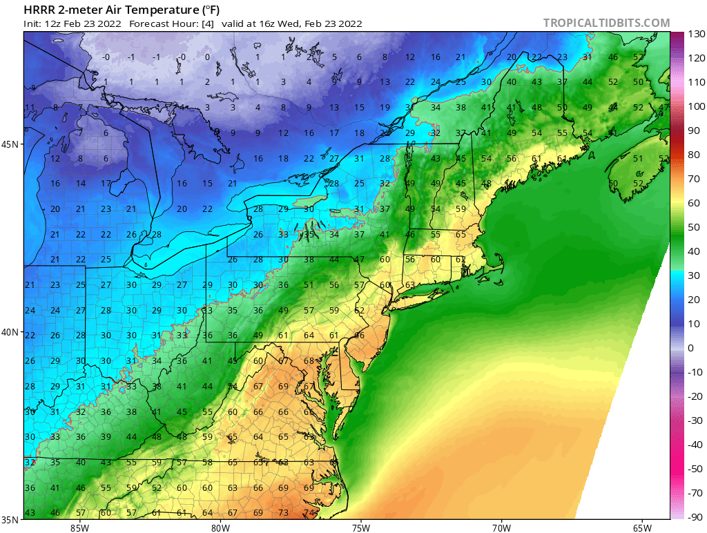
However watch what happens Wednesday evening and overnight into Thursday.

By Thursday morning we are right back below freezing setting the stage for our next storm system to approach from the southwest overnight Thursday into Friday.
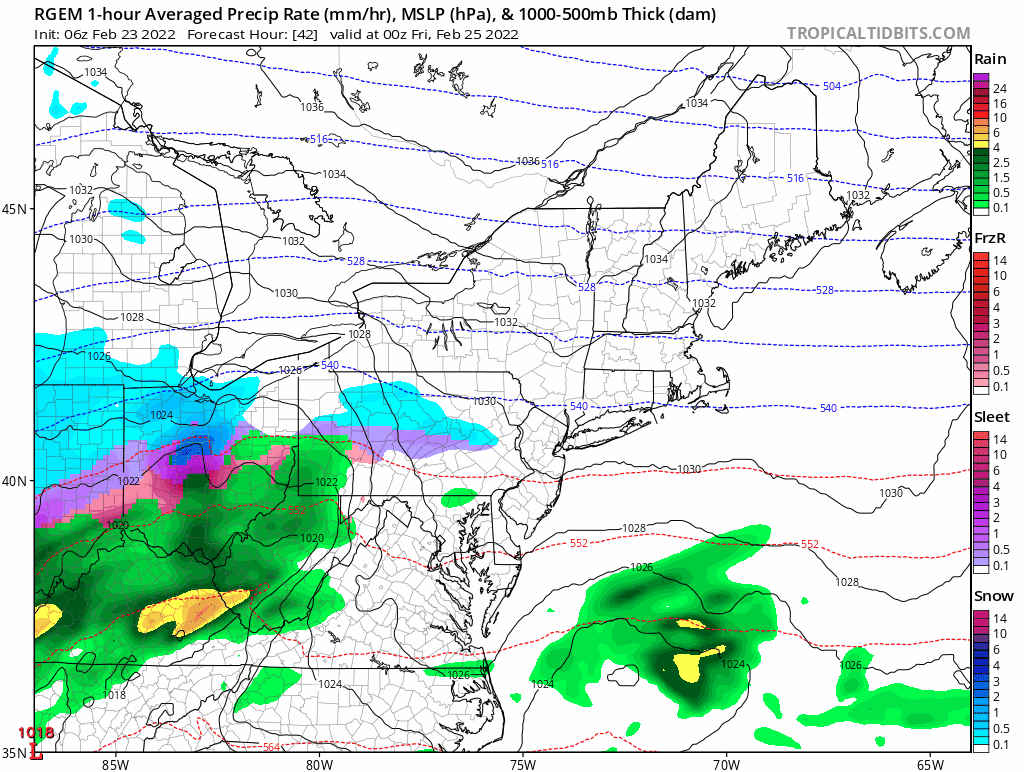
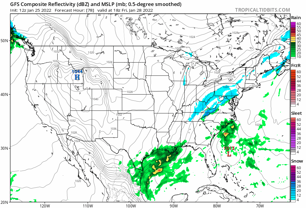
A low pressure system tracking through the Ohio River valley will lift a plume of moisture northward and overrun the region early Friday morning and throughout the day. Because of the cold temperatures in place following Wednesday nights cold front, all locations should start as snow.
Eventually, warmer air aloft will flip southern locations over to a mixed event or plain rain along the coast. Mixed precipitation in the form of sleet may make it as far north as the MA/NH & VT border for a time, but should collapse back south as the low pressure center passes south of the area.
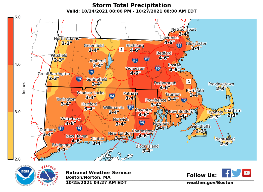
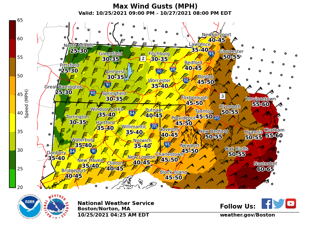
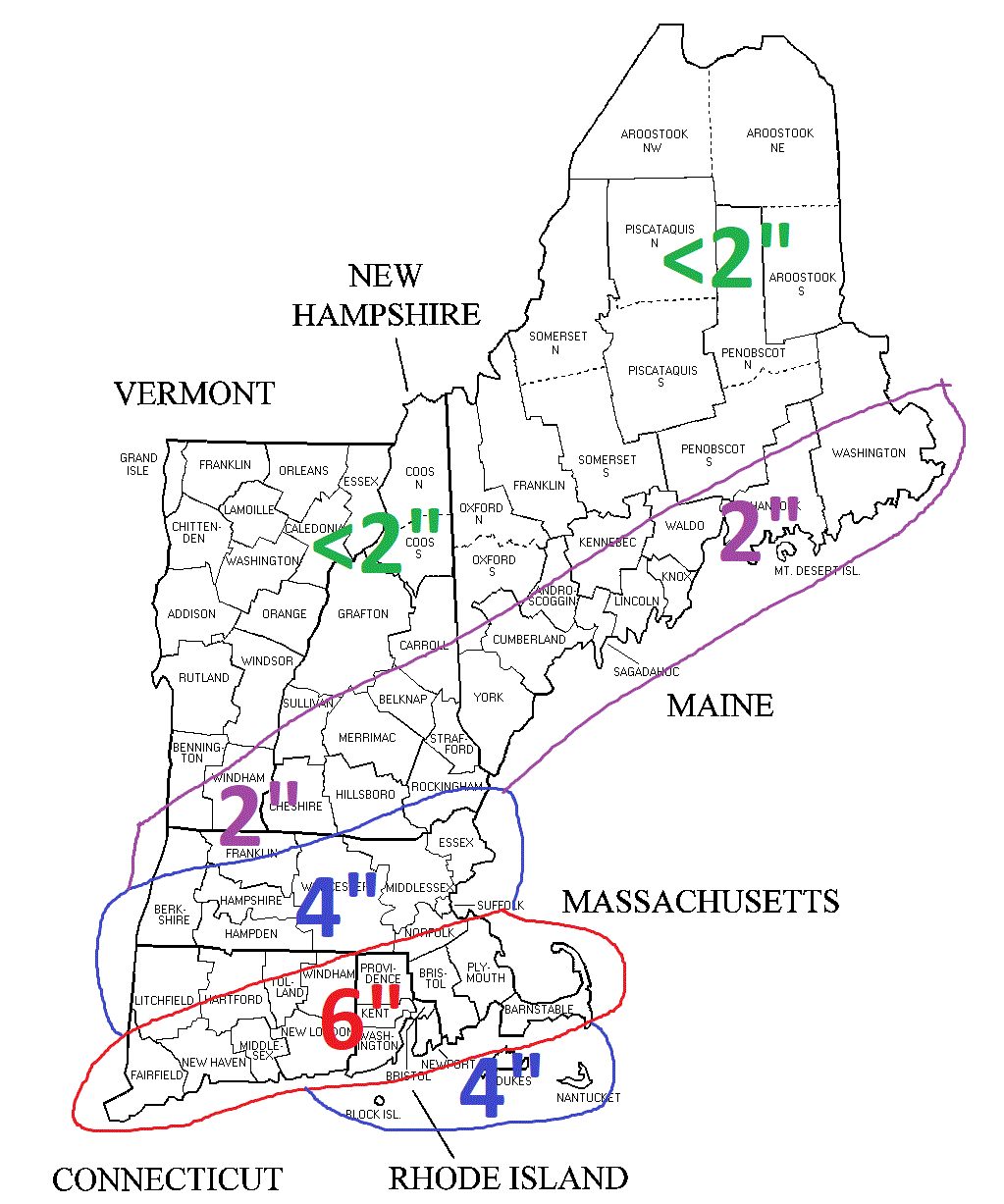
Precipitation is the only hazard with this event as winds and tides are not expected to be an issue. Sporadic power outages may be possible in those areas that receive greater than 6 inches of heavy wet snow.
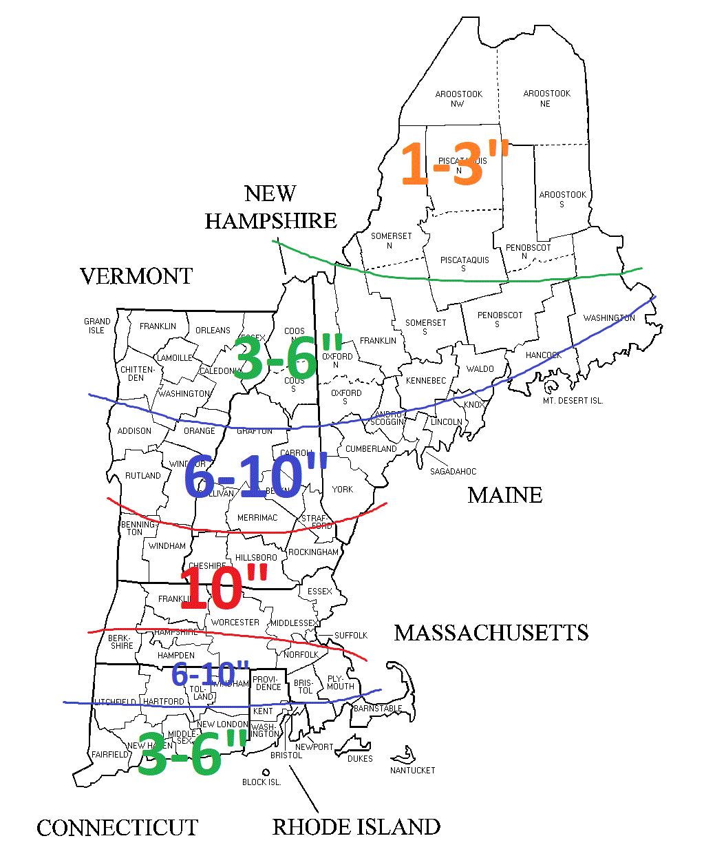
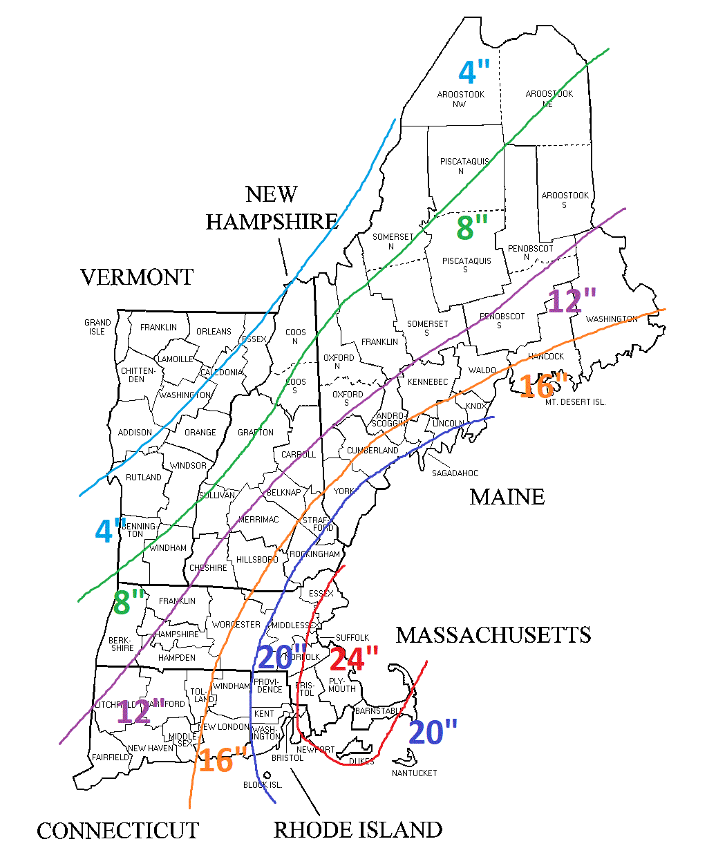
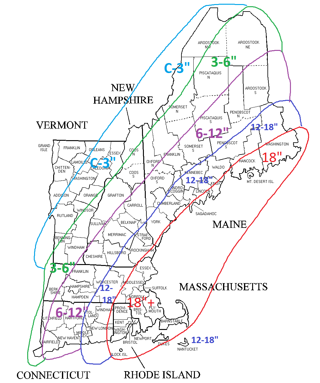
In summary, snow moves in before sunrise and is heaviest around the noon hour. Mixed precipitation moves northward during the day. Those locations that stay all snow could approach 10-12″ but a widespread 6-10″ is expected as shown below.
Snow Forecast
-Chris
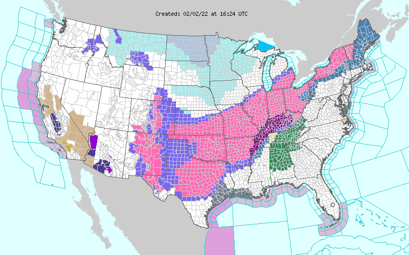
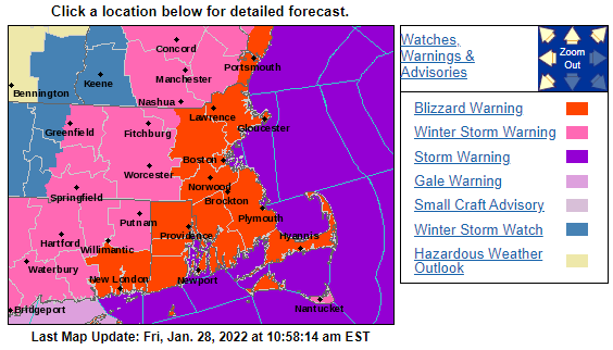
Shown above is the watches and warnings map from the National Weather Service. It is quite hard to miss the shadings of purple and pink from New Mexico to Maine. These shadings represent winter storm advisories (light purple), winter storm watches (blue), winter storm warnings (pink) and ice storm warnings (dark purple). Regardless, it’s obvious that some form of winter weather must be occurring from Roswell to Caribou.
In an attempt to demonstrate why such a wide expanse is being impacted by this event, please see the image above. First I’ll draw your attention to Minnesota, where a 1047 mb high pressure system is pushing southeast from Canada. Just off the image screen east-southeast of New England is another strong high pressure center.
Winds around high pressures flow clockwise. So if you can picture in your mind a clockwise rotating pinwheel for each high pressure…the blades of the pinwheel are bumping into each other right? And they are doing that generally between New Mexico and Maine.
Now the clockwise flow from the Atlantic high pressure system brings air/moisture from the Gulf of Mexico northward and then it starts bumping into the Minnesota high pressure. The air is being compressed along this line. So what happens when you compress a wet paper towel? The moisture is squeezed out.
But what does that mean for New England?
Thursday
Well depending on where you live it means its either going to rain or snow. General thinking is simple, rain for the southern half of Maine, New Hampshire, Vermont and the rest of SNE. Snow for the mountains.
Thursday Night
Overnight Friday a bit more cold air trickles into the region so we will see the rain snow slowly drop south. The transition is not expected to be a clean on from rain to snow. There will likely be a prolonged period of sleet or freezing rain in between.
Friday
The last slug of moisture moves through Friday. We’ll continue to watch the southward march of cold air and the rain/snow line. Right now it appears that most regions may end as snow. The further north one resides the better chance of accumulations. The mountains and northern New England look good for 6-12″. While here in Southern New England a few inches might do it.
It’s a very tricky forecast trying to predict the battle between cold and warm air. I’m inclined to think that cold air wins at the surface while warm air intrudes aloft. So a messy solution is in store. Either way, travel on Friday may be tricky; especially for those areas that flip over to a mix or snow.
-Chris
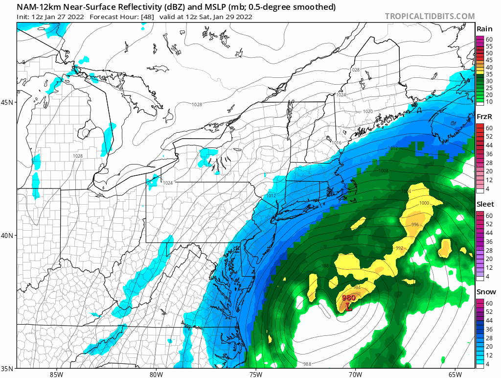
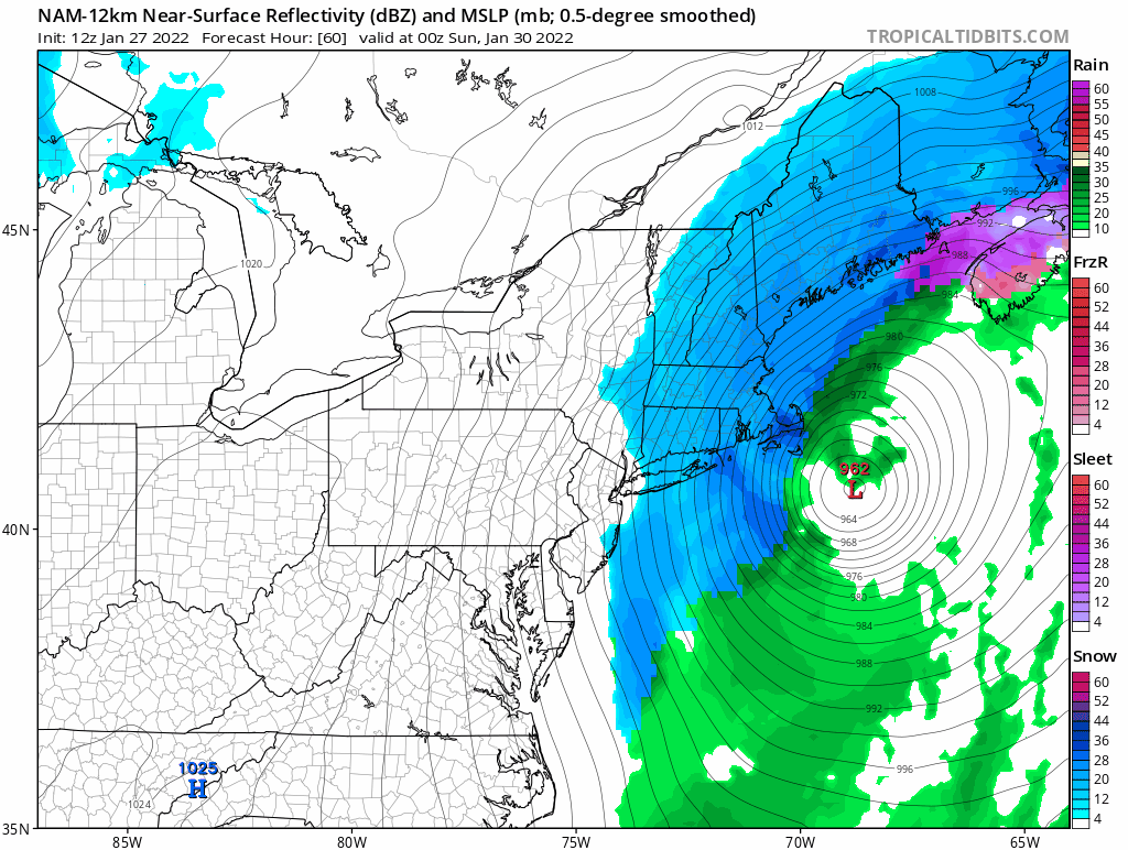
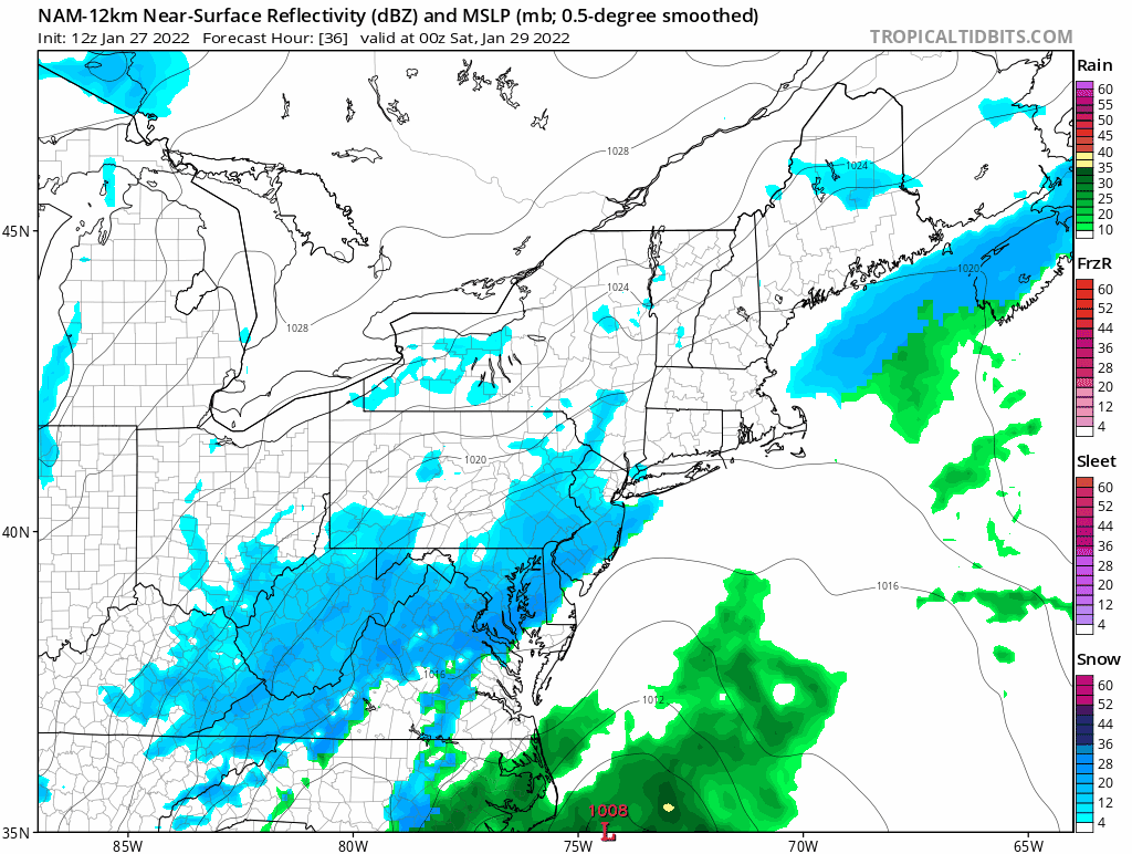
As highlighted a few days ago the forecast for Saturday has held and a strong nor’easter with blizzard conditions is on our doorstep.
Key points:
- Low pressure develops south of Charleston, South Carolina Friday afternoon and rapidly strengthens as it tracks northeast towards Nantucket. Yes; it is undergoing bombogenesis.
- Snow overspreads the region early Saturday morning from south to north. Flakes begin flying at approximately:
- 11p along the south coast.
- 1a along the Massachusetts turnpike.
- 4a along the MA/NH border.
- 7a south of Concord, NH and along the Maine coast.
- 10a the rest of New England.
- Snow will fall heavy during the day Saturday. Snowfall rates 1-2″ per hour are expected. Localized 3-4″ per rates are possible. Across eastern areas thundersnow is possible later in the day.
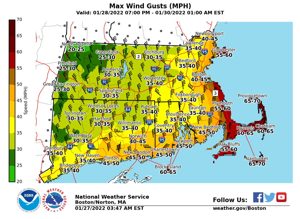
- Wind and coastal flooding issues will be a problem. If you live on the coast and you’ve flooded in the past, you will again during this one. Near hurricane force winds are possible on the Cape and islands. Inland; occasional gusts will be quite strong 30-50 mph.
- The storm winds down from southwest to northeast Saturday night.
- 7p southwest CT.
- 10p the Boston area.
- 4a along the Maine coast.
Storm Evolution
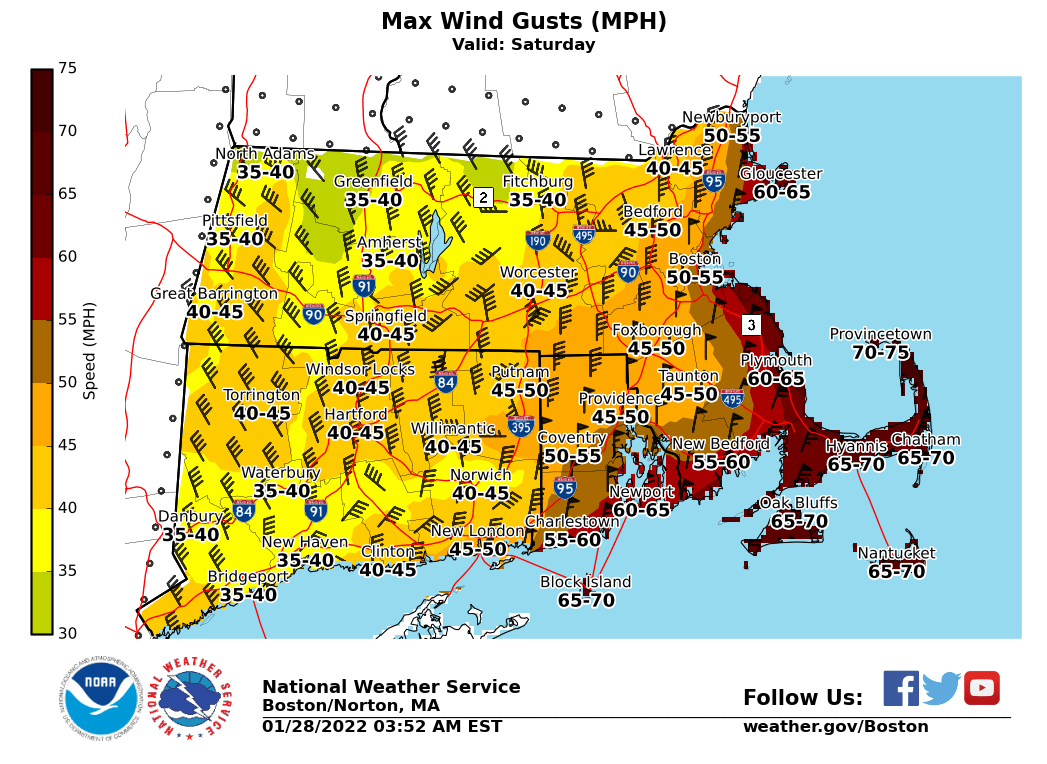
Wind Gusts
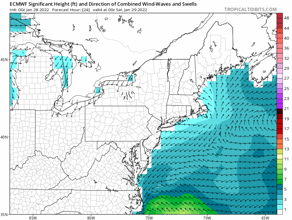
Coastal Issues
Below is a loop of project wave heights. Doesn’t take much interpretation to know that’s a lot of water and energy being pushed up against the coast.
Snowfall
-Chris
Was it cold enough for you this morning? Morning lows across the region were generally near 0 if not just below. Fortunately temperatures are on the rise today with a rather nice day in store tomorrow save for a few flurries or snow showers.
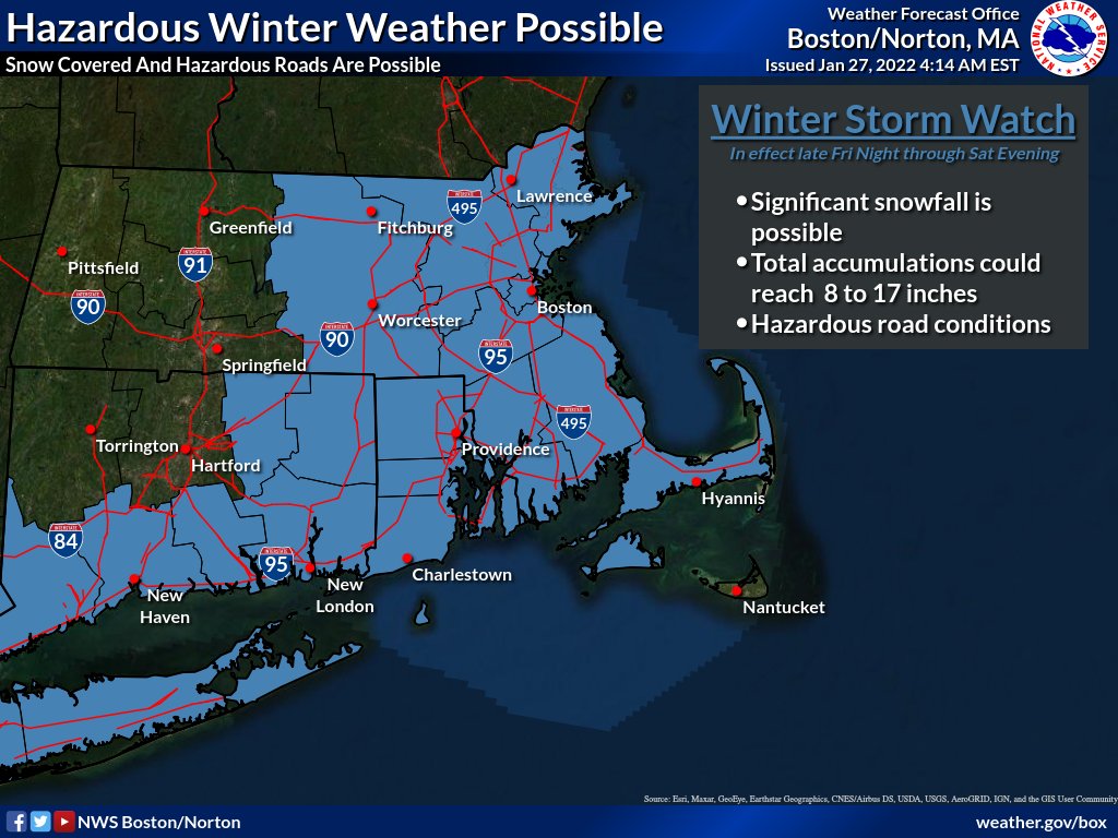
All attention is focused on the forecast for Saturday. As highlighted in my last post, confidence for a major snowstorm has only continued to increase, especially the further east one lives. Winter Storm watches have been issued by the National Weather Service.
Friday
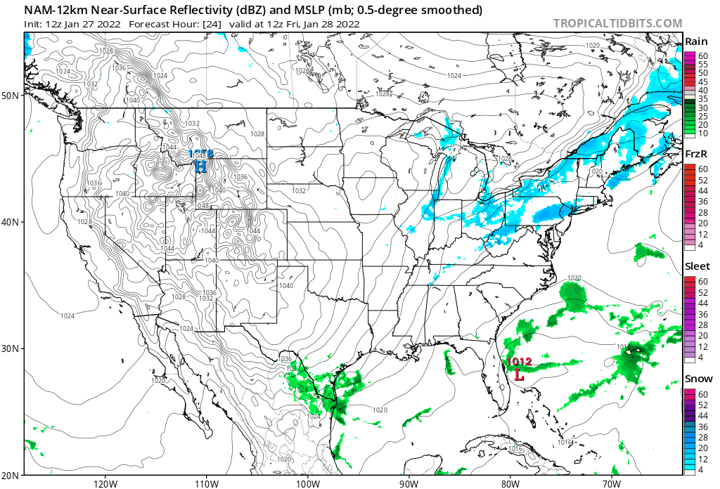
In response to an approaching upper level trough cyclogenesis will occur off the southeast coast. The storm center will be tugged north along the east coast while rapidly strengthening throughout the day and night.
You’ll notice that there are a few flurries and snow showers over the region during the day Friday. Little accumulation is expected as not much should reach the surface.
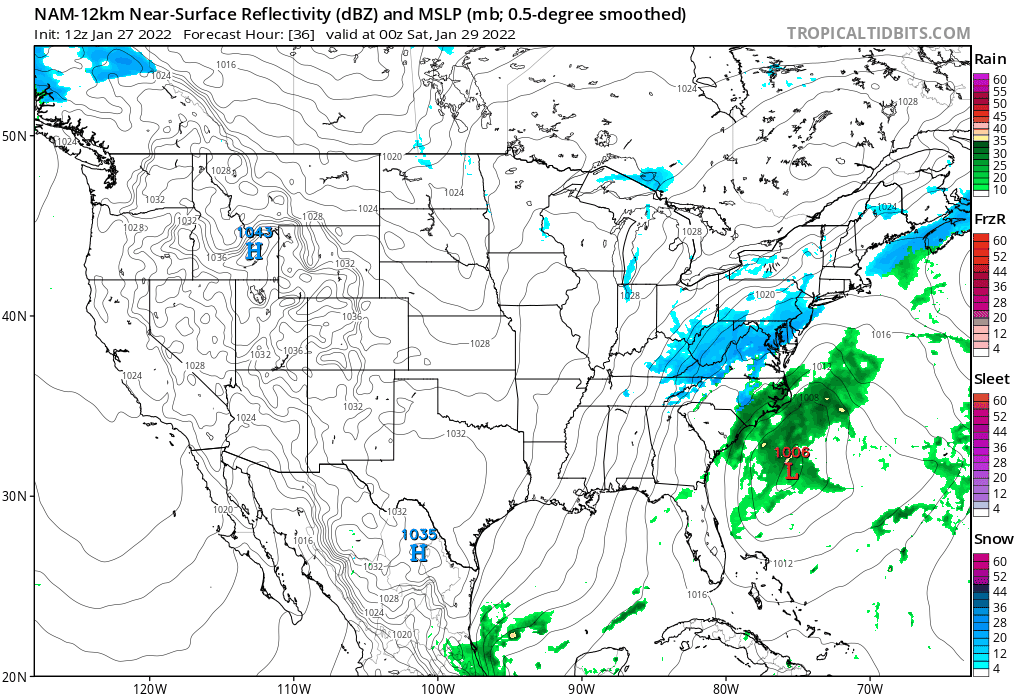
Friday Night
Friday night is when things really start to get going as the storm system rapidly intensifies and precipitation blossoms to the north and west of the center. Snow will increase in coverage from north to south and by morning, nearly everyone in southern New England should have snow outside their window.
Saturday
Zooming in to a more local view. As the storm system reaches its peak intensity southeast of Nantucket it will begin to slow down. I do not currently expect the storm to stall and loop south of the islands, but it will slowly exist northeast. It is during the day Saturday when the bulk of the snow will fall.
Saturday Night
Finally Saturday night as the storm drifts off to Nova Scotia snow will wind down from southwest to northeast. Leaving us all to dig out Sunday morning.
Total Storm Loop
Wind Gusts
Wind gusts from this system will be quite strong. Particularly the closer to the coast one lives. For areas inside and southeast of the 128 loop in eastern Massachusetts, it would not be surprising to see the National Weather Service issue Blizzard warnings. Regardless, blizzard-like conditions are expected at times.
Snowfall
Here is my current thinking for the storm. Felt these ranges are both bold and conservative. There are questions to how far northwest the heaviest precipitation expands. In the Boston area, the 18″ number may be low in a few spots. Someone insides of 495 down to the Cape will see 24″. Just not sure who.
-Chris
It only takes one right? Winter 2021-2022 has been relatively quiet across much of New England with most locations below normal on the year for snowfall. That may be about to change this weekend.
Many of the weather computer guidance models are indicating the potential for a rather significant storm system for the Friday night and Saturday period.
What do we know right now?
- A significant storm system will be somewhere off the east coast.
- Temperatures are sufficiently cold for snow (storm track dependent).
- The tide cycle is astronomically high.
The Set-up
Friday afternoon an area of low pressure will begin organizing off the southeast coastline.

From here the storm system will progress north-northeast up the coast.
As you can see from the model simulation above the storm system is currently forecasted to pass close enough to New England to overspread the region with snowfall. We are still ~4 days away from first snowflakes so the track is far from set in stone. So will hold off on snowfall amounts for now.
Key Takeaways
- A significant storm system is likely to form off the east coast Friday into Saturday.
- The airmass is sufficiently cold for snowfall depending on track. A closer track could introduce the idea of a mix or changeover to rain.
- In addition to snow, strong winds and coastal flooding are a concern due to both the strength of the storm itself and astronomically high tides.
- Specific details such as snow amounts and exact timing are to be refined in the coming days.
In summary, the potential is there for a storm system where one measures snowfall with a yard stick rather than a ruler. However, a lot can change over the next few days. Stay tuned.
-Chris
After an impressively warm first three weeks of October, Mother Nature has decided that it is time for fall. This past weekend featured cool, crisp air and primarily sunny blue skies. However, this work week is one of clouds and rain with cold damp temperatures.
October Temperature Departures
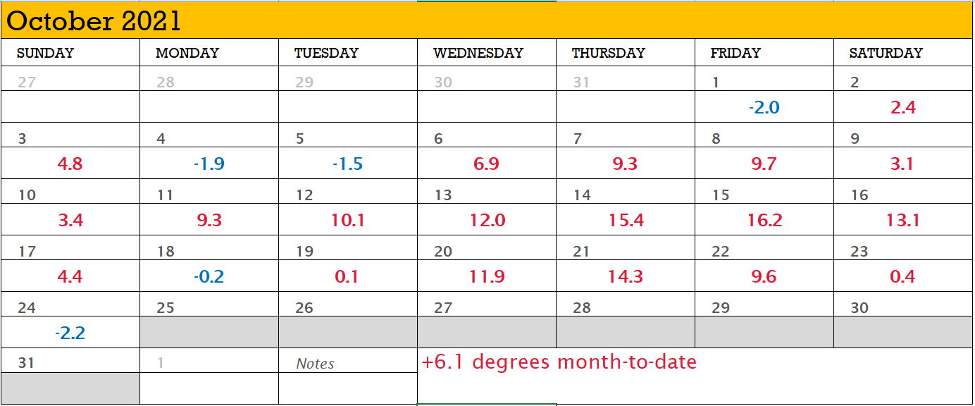
The weather station at Worcester, MA is running 6.1 degrees Fahrenheit above normal month-to-date with 19 of 24 days above normal! But that’s changing.
Nor’easter #1
The warmth that we’ve been experiencing has come to an end as the first nor’easter of the season is on our doorstep. Today’s cool and damp conditions will be followed by even more as a nor’easter moves in for Tuesday and Wednesday.
Above I’ve presented one computer guidance model’s interpretation of the storm systems progression over the next couple days. An area of low pressure will strengthen as it moves north along the east coast and will loop or stall briefly south of Long Island. The storm center itself will be quite strong with its atmospheric pressure bottoming out around 970 mb; potentially equivalent to a minimal hurricane in intensity.
With it, the storm will bring a prolonged period of rain and wind, coastal erosion and flooding, and cool-to-cold temperatures (relative to what we’ve experienced month-to-date).
Rainfall Potential
Storm total rainfall amounts on the order of 2-5″ are possible from the storm system. In terms of confidence in the forecasted amounts; greater confidence in the forecast the further south and east one resides. If you live further north and west, lower confidence in the amounts if the storm does not progress as far north as expected.
As a result of these forecast amounts, flood watches have been raised for the area.
Strong Winds
In response to the storms central pressure dropping into the low 970s, strong north and northeast winds will develop and overtake the region. Consistent with previous storms, the further one lives from the ocean, the lower the wind speeds and gusts will be. Those along the coast or inside of route 128 may experience winds greater than 50 mph. With trees primarily full of leaves and a soggy ground, power outages are possible. So best to be prepared.
Coastal Concerns
For those of you who live on the immediate coast and those flood prone areas (you know who you are), with a strong north, northeast fetch, coastal erosion and flooding concerns are moderate-to-high. Those areas that are prone to coastal flooding should expect issues.
Peek into the Future
The pattern across the eastern US is turning active. Tomorrow’s nor’easter appears to be the first in a series of storm systems to impact the east coast with additional storms possible both Halloween weekend and towards the end of next week.
-Chris

July 2021 is off to a historic start in terms of rainfall for the New England region. Most locations have exceeded their monthly averages in the first week.
The wet weather pattern only continues over the coming days with more rounds of thunderstorms on Thursday followed by Tropical Storm Elsa passing over the region Friday.
Elsa is currently traversing the Carolinas as it speeds up the I-95 corridor.

By this time tomorrow Elsa will be approaching the south coast of New England on its journey to Greenland. Expected to pass over the Providence to Boston corridor, Tropical Storm Warnings and Flash Flood Watches are up for the area.

By the time Elsa moves over the area on Friday the storm system will be racing north-northeast, so any tropical storm conditions will be limited to a small window during the day Friday.
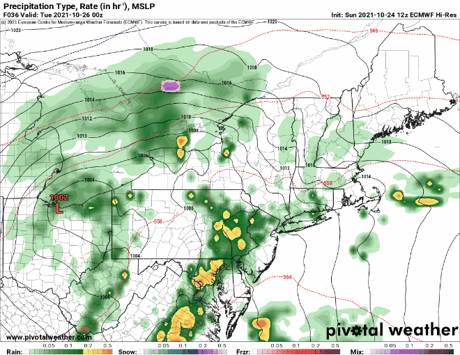
However, with the storm approaching from the south and an upper level trough to the west, periods of rain will likely overspread the region late Thursday evening and last throughout the day Friday.
Thursday PM into Friday AM

Friday Morning

Friday morning to early afternoon is basically a washout as the storm moves through the region. Potential rainfall totals of 2-4″ seem likely, especially northwest of the storm center.
While tropical storm force winds are possible anywhere near the storm system, the stronger wind gusts will be located east of the storm center and primarily confined to the Cape and coastal areas.
Those who live inside 495 and particularly I-95 should probably take time today to prepare for sporadic power outages.
Friday Afternoon

Friday afternoon Elsa exits passes again offshore and heads for downeast Maine. Perhaps in the storms wake a few scattered thunderstorms will pop later in the evening.
In summary, I’ll refer you back to the NWS Watches and Warnings image. If you live under the red shading, then 1-2″ of rain with the potential for power outages. If you live under the green shading, then 2-4″ of rain with the potential for flash flooding in low lying areas.
The weekend looks nice.
-Chris
The old saying is that the month of March comes in like a lion and goes out like a lamb. This year March was a lamb the entire month as most of southern New England received nearly zero snowfall. April has started out pretty slow as well. In fact, the region is currently experiencing moderate drought conditions.

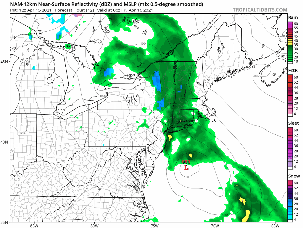
Fortunately a significant dent should be put into these drought conditions over the next 24-48 hours. A large upper level storm system drifting southeast over the Great Lakes region will pass over or south of New England tonight and tomorrow.

In response an area of low pressure is in the process of developing off the developing off the Maryland coast. This low pressure will drift northward and strengthen bringing periods of rain and snow to the region.
Thursday
Thursday morning is overcast and dry for most of the region; except for the Hudson River Valley.
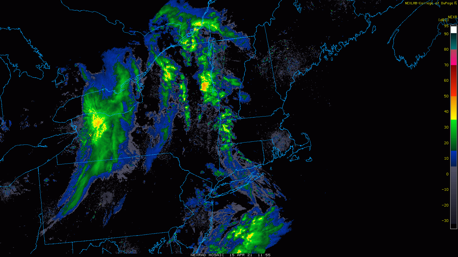
Throughout the morning and afternoon the radar will fill in across the region from west to east. By evening many areas are raining. It may take a bit longer across eastern Southern New England.
Thursday Overnight
During the overnight hours the storm system will continue its march towards Nantucket. Colder air, potentially supportive of snow, will wrap into the northern and western side of the system. By Friday AM, many of the elevated areas (Berkshires, Green Mountains, Monadnock Range, northern Worcester County) have likely flipped over to snow.
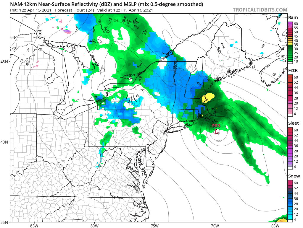
Friday
Friday is the wild card. How much cold air gets wrapped into the system? Does the lowest 3,000 feet of the atmospheric column cool enough to support snowfall? This is certainly a tricky situation.
Computer model guidance is trending towards yes. But it is April 15th, so caution needs to be exercised. Currently I expect most locations to at least have snow in the air at some point on Friday as the storm center reaches peak intensity near Nantucket. However, accumulations at elevations below 1,500 feet are likely to be minimal.
However, this is a very dynamic system and there are countless examples where a late fall or late spring storm system has brought snow to the region.
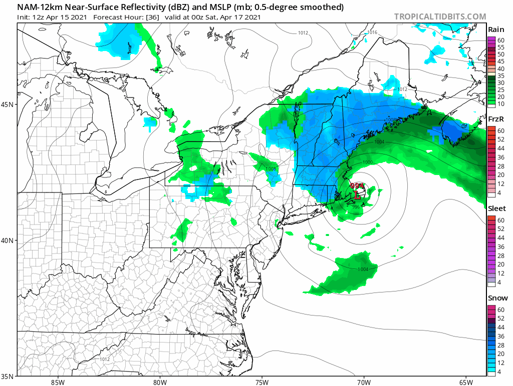
Friday Overnight
There is currently a bit of a traffic jam over the north Atlantic so this system will be slow to exit. Though the storm center will linger near southern New England overnight Friday, the bulk of precipitation will have fallen and the area will be left with off and on rain/snow showers through the night until the storm center finally drifts off to the east.
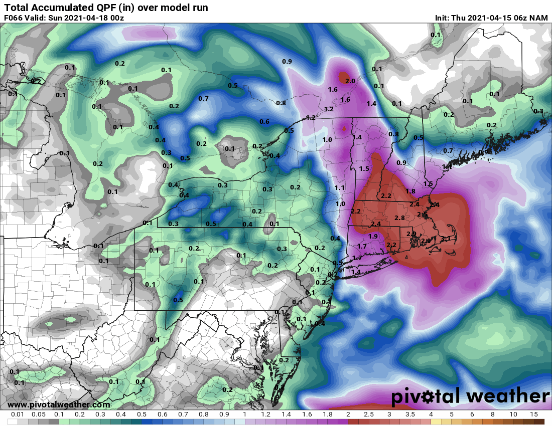
Total Precipitation
This storm system will not lack for precipitation and should but a major dent in the previously discussed drought. And inch of rain looks likely for most locations with some areas receiving > 2″.
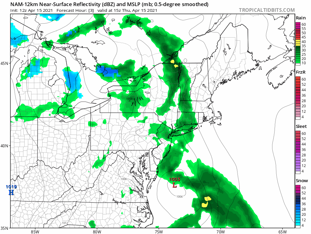
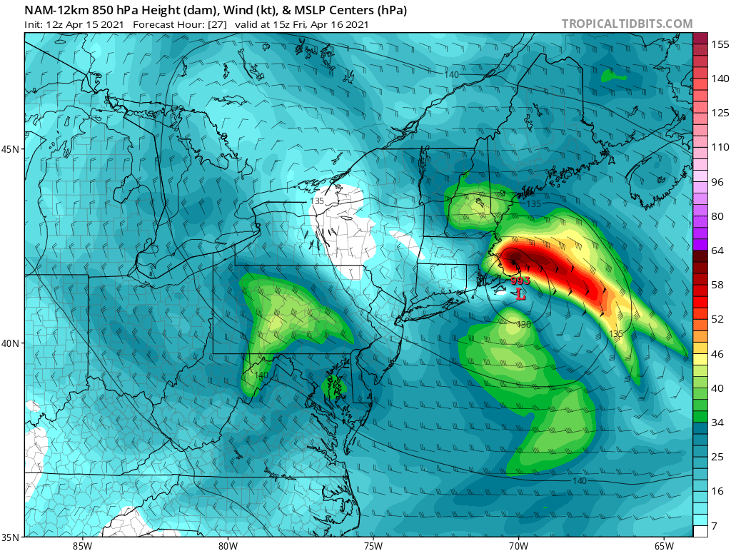
Part of what will aid the copious amounts of precipitation will be a strong low level jet pointing in off the ocean transporting moisture rich ocean air over the region. Shown below is a figure for Friday morning. Note the strong “jet” of air pointing directly at southern New England from the east.
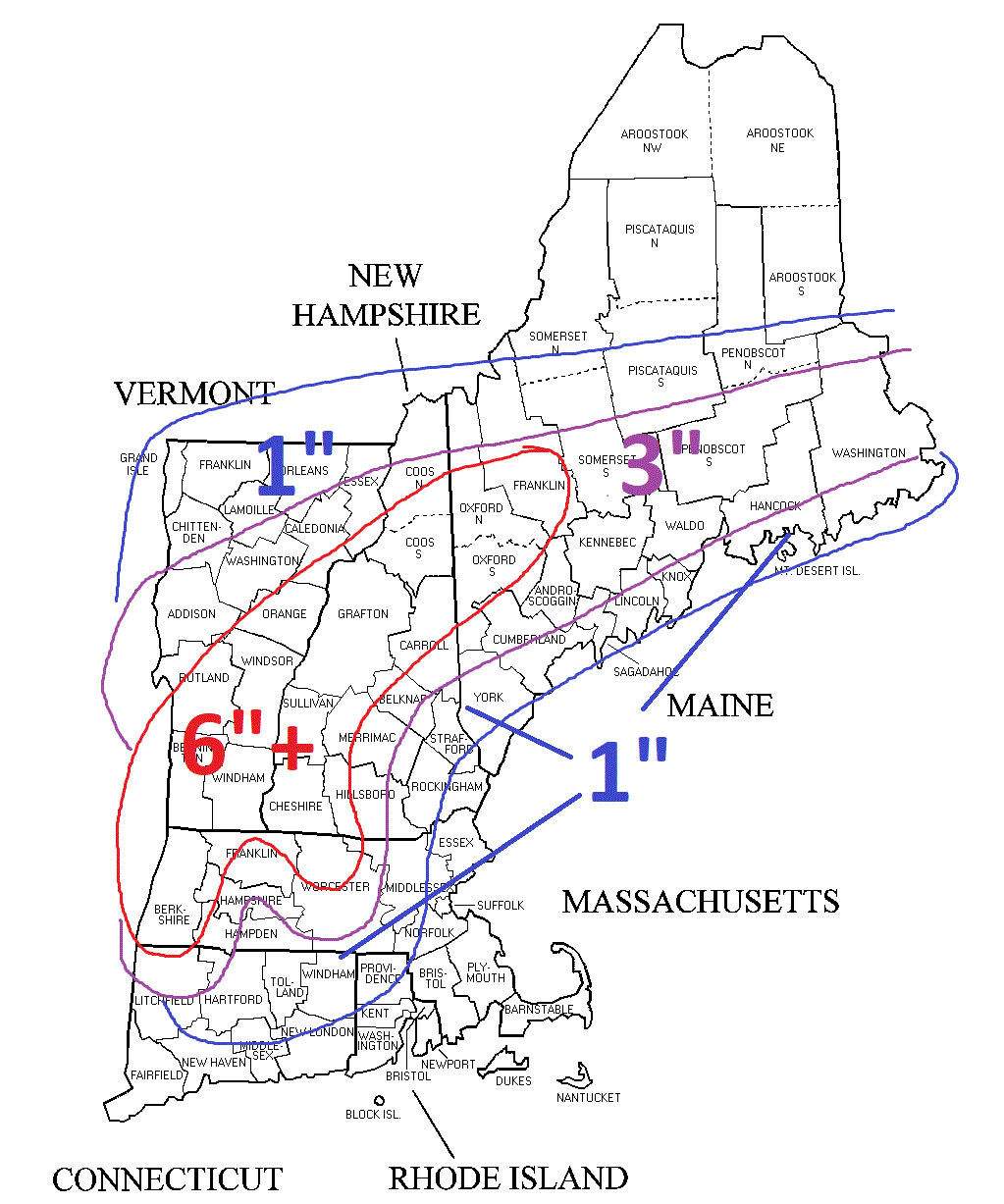
Snowfall
This is a tricky one and very likely will be elevation dependent which I tried to highlight with the below map.
-Chris
A weak storm system traversing the northern portion of the country will swing through New England tomorrow afternoon. A quick burst of snow and rain is expected. Locations north and west of 495 will likely start as snow. South and east of 495 is likely all rain.
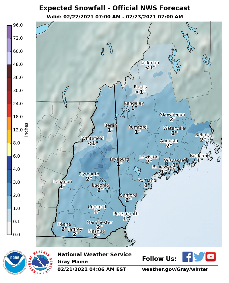
In general 1-2″ are expected in those locations where snow falls. Adding to the existing snow pack.
-Chris
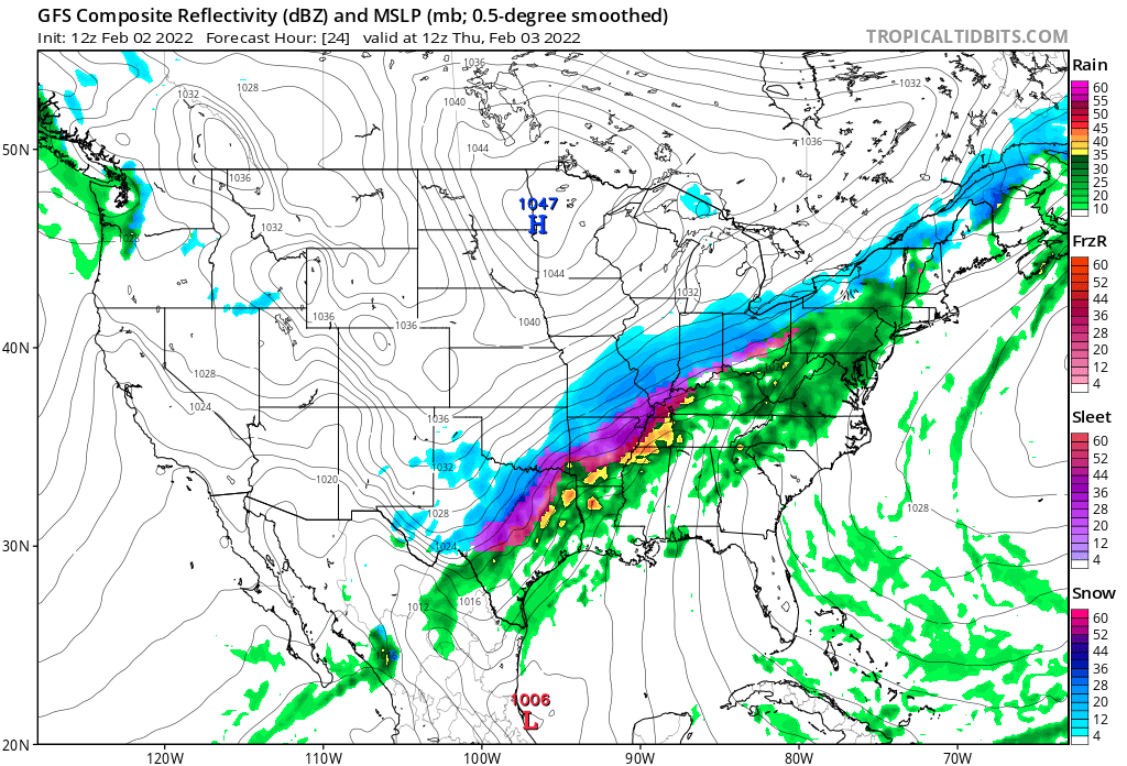
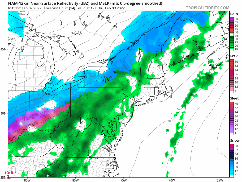
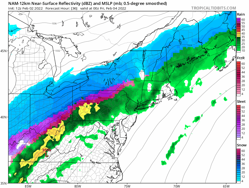
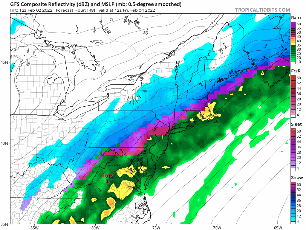
The active weather pattern continues here in New England as yet another storm system is marching northeastward from the Gulf Coast. Currently gathering Gulf moisture and bringing rain, snow and ice to Texas and Louisiana, a storm system will slowly traverse up the Appalachian Trail over the next couple days before eventually sliding south of New England.
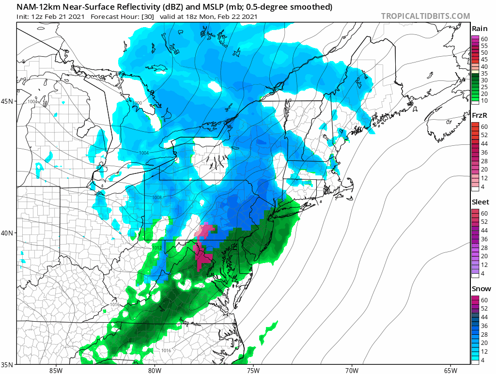
Thursday morning the storm system will be on approach from the southwest with snow overspreading the area from south to north throughout the day. With high pressure to the north, cold air will be locked in place and precipitation will fall as mainly snow.
The above loop is 30 hours long and many locations have snow flakes in the air for perhaps greater than 20 hours. However, the total amount of liquid that falls from the sky isn’t too significant with most locations between 0.25 – 0.75″ of liquid equivalent.
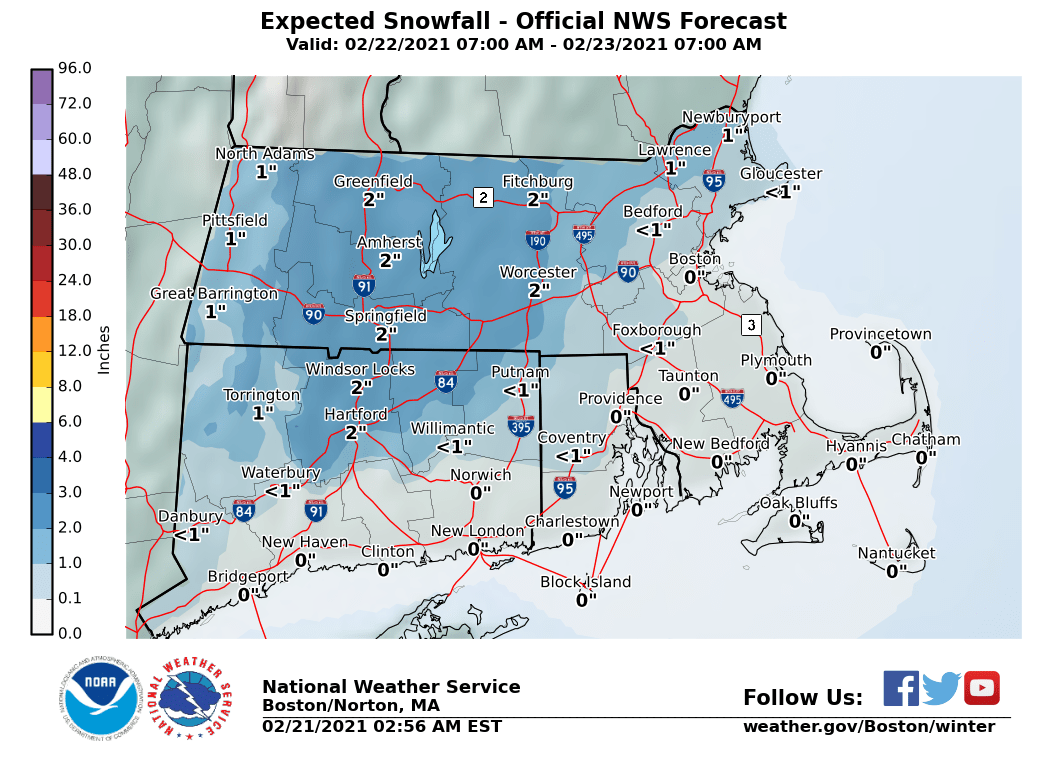
Using a rough 10:1 snow to liquid ratio gives a general 3-6″ snowfall for the area. With higher amounts to the south and lower amounts north. In general, this system as currently expected is more of a prolonged mood or snow globe snow event. Flakes may be in the air for a long time, but ultimately there isn’t much to shovel.
-Chris
